
Greenhead, Northumberland
Encyclopedia
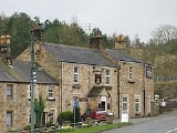
Greenhead is a village
in Northumberland
, England
. The village is on the Military Road (B6318), about 17 miles (27 km) from Chollerford
, 3 miles (5 km) from Haltwhistle
and 9 miles (14 km) from Brampton, Cumbria
along the A69 road
. The A69 road
bypasses
the village, but until the 1980s all vehicular traffic passed through the village. The village lies just outside the Northumberland National Park
, close to Hadrian's Wall
. Just to the north of the village is the 12th century Thirlwall Castle
, recently opened to the public. Nearby villages include Upper Denton
and Haltwhistle
.
A former Methodist chapel in the village is now a youth hostel.
The Pennine Way
, the UK's first National Trail, passes through Greenhead.
.
is a 12th-century castle
on the bank of the River Tipalt close to the village of Greenhead and approximately 20 miles (32 km) west of Hexham
. It was built in the 12th century, and later strengthened using stones from nearby Hadrian's Wall
, but began to fall into disrepair in the 17th century. The site is protected by Grade I listed building and Scheduled Ancient Monument status.
, also known as the Tyne Valley Line. The line was opened in 1838, and links the city of Newcastle upon Tyne
in Tyne and Wear
with Carlisle
in Cumbria
. The line follows the course of the River Tyne through Northumberland
. The station opened on 19 July 1836 when the section from Carlisle London Road to Greenhead opened. The station closed in 1967.
Village
A village is a clustered human settlement or community, larger than a hamlet with the population ranging from a few hundred to a few thousand , Though often located in rural areas, the term urban village is also applied to certain urban neighbourhoods, such as the West Village in Manhattan, New...
in Northumberland
Northumberland
Northumberland is the northernmost ceremonial county and a unitary district in North East England. For Eurostat purposes Northumberland is a NUTS 3 region and is one of three boroughs or unitary districts that comprise the "Northumberland and Tyne and Wear" NUTS 2 region...
, England
England
England is a country that is part of the United Kingdom. It shares land borders with Scotland to the north and Wales to the west; the Irish Sea is to the north west, the Celtic Sea to the south west, with the North Sea to the east and the English Channel to the south separating it from continental...
. The village is on the Military Road (B6318), about 17 miles (27 km) from Chollerford
Chollerford
Chollerford is a village in Northumberland, England. It is situated approximately four miles to the north of Hexham on the B6318 road, not far from Hadrian's Wall. There is a roundabout in the village where the B6318 and B6320 roads meet, and the traffic light-controlled Chollerford Bridge...
, 3 miles (5 km) from Haltwhistle
Haltwhistle
Haltwhistle is a small town and civil parish in Northumberland, England, situated east of Brampton, near Hadrian's Wall, and the villages of Plenmeller, Rowfoot and Melkridge...
and 9 miles (14 km) from Brampton, Cumbria
Brampton, Carlisle, Cumbria
Brampton is a small market town and civil parish within the City of Carlisle district of Cumbria, England about 9 miles east of Carlisle and 2 miles south of Hadrian's Wall. It is situated off the A69 road which bypasses it...
along the A69 road
A69 road
The A69 is a major road in northern England, running east-west across the Pennines, through the counties of Tyne and Wear, Northumberland and Cumbria. Originally the road started in Blaydon, but since the creation of the A1 Western Bypass around Newcastle upon Tyne, it now starts at Denton Burn a...
. The A69 road
A69 road
The A69 is a major road in northern England, running east-west across the Pennines, through the counties of Tyne and Wear, Northumberland and Cumbria. Originally the road started in Blaydon, but since the creation of the A1 Western Bypass around Newcastle upon Tyne, it now starts at Denton Burn a...
bypasses
Bypass (road)
A bypass is a road or highway that avoids or "bypasses" a built-up area, town, or village, to let through traffic flow without interference from local traffic, to reduce congestion in the built-up area, and to improve road safety....
the village, but until the 1980s all vehicular traffic passed through the village. The village lies just outside the Northumberland National Park
Northumberland National Park
Northumberland National Park is the northernmost national park in England. It covers an area of more than 1030 km² between the Scottish Border in the north to just south of Hadrian's Wall. It is one of the least populated and least visited of the National Parks...
, close to Hadrian's Wall
Hadrian's Wall
Hadrian's Wall was a defensive fortification in Roman Britain. Begun in AD 122, during the rule of emperor Hadrian, it was the first of two fortifications built across Great Britain, the second being the Antonine Wall, lesser known of the two because its physical remains are less evident today.The...
. Just to the north of the village is the 12th century Thirlwall Castle
Thirlwall Castle
Thirlwall Castle is a 12th-century castle in Northumberland, England, on the bank of the River Tipalt close to the village of Greenhead and approximately west of Hexham. It was built in the 12th century, and later strengthened using stones from nearby Hadrian's Wall, but began to fall into...
, recently opened to the public. Nearby villages include Upper Denton
Upper Denton
Upper Denton is a small village and civil parish in the north of Cumbria, England about 1 km north of the A69 road linking Haltwhistle and Brampton. The village is situated on the line of the Roman Stanegate which ran from Corbridge to Carlisle . Just 1 km to the north across the river...
and Haltwhistle
Haltwhistle
Haltwhistle is a small town and civil parish in Northumberland, England, situated east of Brampton, near Hadrian's Wall, and the villages of Plenmeller, Rowfoot and Melkridge...
.
A former Methodist chapel in the village is now a youth hostel.
The Pennine Way
Pennine Way
The Pennine Way is a National Trail in England. The trail runs from Edale, in the northern Derbyshire Peak District, north through the Yorkshire Dales and the Northumberland National Park and ends at Kirk Yetholm, just inside the Scottish border. The path runs along the Pennine hills, sometimes...
, the UK's first National Trail, passes through Greenhead.
Governance
Greenhead, Northumberland is in the parliamentary constituency of HexhamHexham (UK Parliament constituency)
- Elections in the 2000s :- Elections in the 1990s :- Elections in the 1980s :- Elections in the 1970s :-Notes and references:...
.
Landmarks
Thirlwall CastleThirlwall Castle
Thirlwall Castle is a 12th-century castle in Northumberland, England, on the bank of the River Tipalt close to the village of Greenhead and approximately west of Hexham. It was built in the 12th century, and later strengthened using stones from nearby Hadrian's Wall, but began to fall into...
is a 12th-century castle
Castle
A castle is a type of fortified structure built in Europe and the Middle East during the Middle Ages by European nobility. Scholars debate the scope of the word castle, but usually consider it to be the private fortified residence of a lord or noble...
on the bank of the River Tipalt close to the village of Greenhead and approximately 20 miles (32 km) west of Hexham
Hexham
Hexham is a market town and civil parish in Northumberland, England, located south of the River Tyne, and was the administrative centre for the Tynedale district from 1974 to 2009. The three major towns in Tynedale were Hexham, Prudhoe and Haltwhistle, although in terms of population, Prudhoe was...
. It was built in the 12th century, and later strengthened using stones from nearby Hadrian's Wall
Hadrian's Wall
Hadrian's Wall was a defensive fortification in Roman Britain. Begun in AD 122, during the rule of emperor Hadrian, it was the first of two fortifications built across Great Britain, the second being the Antonine Wall, lesser known of the two because its physical remains are less evident today.The...
, but began to fall into disrepair in the 17th century. The site is protected by Grade I listed building and Scheduled Ancient Monument status.
Transport
The village was served by Greenhead railway station on the Newcastle and Carlisle RailwayNewcastle and Carlisle Railway
The Newcastle and Carlisle Railway, occasionally referred to as the Tyne Valley Line, is a railway line in northern England. The line was built in the 1830s, and links the city of Newcastle upon Tyne in Tyne and Wear with in Cumbria. Formal opening took place on 18 June 1838.The line follows the...
, also known as the Tyne Valley Line. The line was opened in 1838, and links the city of Newcastle upon Tyne
Newcastle upon Tyne
Newcastle upon Tyne is a city and metropolitan borough of Tyne and Wear, in North East England. Historically a part of Northumberland, it is situated on the north bank of the River Tyne...
in Tyne and Wear
Tyne and Wear
Tyne and Wear is a metropolitan county in north east England around the mouths of the Rivers Tyne and Wear. It came into existence as a metropolitan county in 1974 after the passage of the Local Government Act 1972...
with Carlisle
Carlisle railway station
Carlisle railway station, also known as Carlisle Citadel station, is a railway station whichserves the Cumbrian City of Carlisle, England, and is a major station on the West Coast Main Line, lying south of Glasgow Central, and north of London Euston...
in Cumbria
Cumbria
Cumbria , is a non-metropolitan county in North West England. The county and Cumbria County Council, its local authority, came into existence in 1974 after the passage of the Local Government Act 1972. Cumbria's largest settlement and county town is Carlisle. It consists of six districts, and in...
. The line follows the course of the River Tyne through Northumberland
Northumberland
Northumberland is the northernmost ceremonial county and a unitary district in North East England. For Eurostat purposes Northumberland is a NUTS 3 region and is one of three boroughs or unitary districts that comprise the "Northumberland and Tyne and Wear" NUTS 2 region...
. The station opened on 19 July 1836 when the section from Carlisle London Road to Greenhead opened. The station closed in 1967.
External links
- Northumberland Communities (accessed: 10 November 2008)