
Great Langton
Encyclopedia
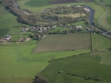
Great Langton is a small village and civil parish
in the district of Hambleton
, North Yorkshire
, England
. The village lies on the B6271 road, between Scorton and Northallerton
, on the northern bank of the River Swale
and it was once known as Langton-upon-Swale.
The village church is St Wilfrid's Church; there was also a Chapel
of the Good Shepherd, which has now been converted into a residential property. There was once a school in Great Langton but this too has closed and is now a residential property. The village pub, which was known as The Langton Hotel until it changed its name to The Wishing Well in the 1970s, closed in 2004.
The village is a short distance from Kiplin Hall
, the stately home built by George Calvert, 1st Baron Baltimore
, the founder of Maryland, USA.
nearby.
 Great Langton has a small number of Sites of Importance for Nature Conservation. These include Great Langton Pond located in grid reference SE289959, Poole's Waist at SE306943, River Swale at SE257966 and Winterwalk Wood at SE302955, in close vicinity to Little Langton
.
Great Langton Pond has many ornithological (wetland) purposes as well as plenty of decent angling
. The pond is known to contain species such as barbel
, carp
and chub
.
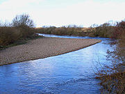
The River Swale
has been known to be subject to flooding and is monitored closely by the Environment Agency
. Although Great Langton is located in a primary area for fishing, no local residents are in the trade. The River Swale also attracts large numbers of duck
into the village, commonly seen around winter. The ducks tend to arrive around mid-September having travelled around 2000 miles (3,218.7 km) from central CIS
. They return around April, the journey taking several weeks.
Poole's Waist is one of many oxbow lake
s located on the River Swale. River water still floods through Poole's Waist during periods of high rainfall.
(Mesolithic
) period, there is little sign of any human impacts on the landscape, but there are signs of forest fires shown by fire climax vegetation, which could have been prevalent as a result of Mesolithic activity. Farming began only in the mid Holocene period, so human activity is likely to have been far larger from then onwards. Farming would have greatly increased and caused significant changes in the fluvial sediment
regime through woodland clearance and colluvial hillwash
.
Therefore Great Langton shows signs of rural
activity. Also there are signs of quarrying since there is a disused quarry located on part of the old river bed. Hence the Swale is seen to have high sand and gravel content.
Great Langton first became a parish in 1823.
On 27 February 2008 much of North Yorkshire experienced tremors as a cause of the earthquake with an epicentre in Lincolnshire
. Luckily no damage was caused to the village.
for the parish of Great Langton reveals that 83% of the inhabitants are Christian
, with only 10.8% stating that they have 'no religion'. The remaining 6.2% did not wish to say. Every year Great Langton holds a church fete to raise money for St Wilfrid's Church. Although the church is still running, it has been slowly declining in usage due to a lack of funding and of village attendance.
, Yafforth
and Northallerton
. For the bus timetable to and from Great Langton here. There are regular train services between Northallerton and London
allowing for a relatively easy connection. A typical fare will be around £80. To view train journey times here.
the British Isles
experience a maritime climate
characterised by relatively cool summers and mild winters. Compared with other parts of the country, North Yorkshire is slightly warmer and sunnier in the summer and colder and frostier in the winter. Owing to its inland position, and sheltered by the Pennines
to the west, North Yorkshire is one of the driest counties in the UK, receiving, on average, less than 600 mm (23.6 in) of rain per year. The mean annual daily duration of bright sunshine is three hours and 42 minutes.
There are two distinct local weather phenomenon, marked downslope lee winds caused by the proximity of the Pennines, leading to super geostrophic winds
which can reach in excess of 60 KT (70 mph), most commonly in winter and spring. In the winter the presence of a subsidence inversion between the Pennines and the North Yorks Moors can allow dense, persistent fog
to form which can last for several days.
Civil parish
In England, a civil parish is a territorial designation and, where they are found, the lowest tier of local government below districts and counties...
in the district of Hambleton
Hambleton
Hambleton is a local government district of North Yorkshire, England. The main town and administrative centre is Northallerton, and includes the market towns and major villages of Bedale, Thirsk, Great Ayton, Stokesley and Easingwold....
, North Yorkshire
North Yorkshire
North Yorkshire is a non-metropolitan or shire county located in the Yorkshire and the Humber region of England, and a ceremonial county primarily in that region but partly in North East England. Created in 1974 by the Local Government Act 1972 it covers an area of , making it the largest...
, England
England
England is a country that is part of the United Kingdom. It shares land borders with Scotland to the north and Wales to the west; the Irish Sea is to the north west, the Celtic Sea to the south west, with the North Sea to the east and the English Channel to the south separating it from continental...
. The village lies on the B6271 road, between Scorton and Northallerton
Northallerton
Northallerton is an affluent market town and civil parish in the Hambleton district of North Yorkshire, England. It lies in the Vale of Mowbray and at the northern end of the Vale of York. It has a population of 15,741 according to the 2001 census...
, on the northern bank of the River Swale
River Swale
The River Swale is a river in Yorkshire, England and a major tributary of the River Ure, which itself becomes the River Ouse, emptying into the North Sea via the Humber Estuary....
and it was once known as Langton-upon-Swale.
The village church is St Wilfrid's Church; there was also a Chapel
Chapel
A chapel is a building used by Christians as a place of fellowship and worship. It may be part of a larger structure or complex, such as a church, college, hospital, palace, prison or funeral home, located on board a military or commercial ship, or it may be an entirely free-standing building,...
of the Good Shepherd, which has now been converted into a residential property. There was once a school in Great Langton but this too has closed and is now a residential property. The village pub, which was known as The Langton Hotel until it changed its name to The Wishing Well in the 1970s, closed in 2004.
The village is a short distance from Kiplin Hall
Kiplin Hall
Kiplin Hall is a Jacobean historic house at Kiplin in North Yorkshire, England, that is now a Grade I listed building. It stands by the River Swale in the Vale of Mowbray. The nearest villages are Scorton, Great Langton and Bolton-on-Swale...
, the stately home built by George Calvert, 1st Baron Baltimore
George Calvert, 1st Baron Baltimore
Sir George Calvert, 1st Baron Baltimore, 8th Proprietary Governor of Newfoundland was an English politician and colonizer. He achieved domestic political success as a Member of Parliament and later Secretary of State under King James I...
, the founder of Maryland, USA.
Etymology
The name 'Great Langton' derives from Old English meaning ‘Long farm/settlement’. ‘Lang’ is the old Saxon word for ‘long’, and ‘Tun’ being ‘town’. It is known as Great Langton because there is a Little LangtonLittle Langton
Little Langton is a hamlet in the parish of Great Langton, in North Yorkshire, England....
nearby.
Sites of interest
Little Langton
Little Langton is a hamlet in the parish of Great Langton, in North Yorkshire, England....
.
Great Langton Pond has many ornithological (wetland) purposes as well as plenty of decent angling
Angling
Angling is a method of fishing by means of an "angle" . The hook is usually attached to a fishing line and the line is often attached to a fishing rod. Fishing rods are usually fitted with a fishing reel that functions as a mechanism for storing, retrieving and paying out the line. The hook itself...
. The pond is known to contain species such as barbel
Barbel (fish species)
Barbels are group of small carp-like freshwater fish, almost all of the genus Barbus. They are usually found in gravel and rocky-bottomed slow-flowing waters with high dissolved oxygen content. A typical adult barbel will range from 25 to 100 cm in length and weigh anywhere between 200 g...
, carp
Carp
Carp are various species of oily freshwater fish of the family Cyprinidae, a very large group of fish native to Europe and Asia. The cypriniformes are traditionally grouped with the Characiformes, Siluriformes and Gymnotiformes to create the superorder Ostariophysi, since these groups have certain...
and chub
Squalius
Squalius is a ray-finned fish genus in the family Cyprinidae, containing the European chubs . This genus belongs to the subfamily Leuciscinae as other chubs and daces generally do....
.
The River Swale
River Swale
The River Swale is a river in Yorkshire, England and a major tributary of the River Ure, which itself becomes the River Ouse, emptying into the North Sea via the Humber Estuary....
has been known to be subject to flooding and is monitored closely by the Environment Agency
Environment Agency
The Environment Agency is a British non-departmental public body of the Department for Environment, Food and Rural Affairs and an Assembly Government Sponsored Body of the Welsh Assembly Government that serves England and Wales.-Purpose:...
. Although Great Langton is located in a primary area for fishing, no local residents are in the trade. The River Swale also attracts large numbers of duck
Duck
Duck is the common name for a large number of species in the Anatidae family of birds, which also includes swans and geese. The ducks are divided among several subfamilies in the Anatidae family; they do not represent a monophyletic group but a form taxon, since swans and geese are not considered...
into the village, commonly seen around winter. The ducks tend to arrive around mid-September having travelled around 2000 miles (3,218.7 km) from central CIS
Commonwealth of Independent States
The Commonwealth of Independent States is a regional organization whose participating countries are former Soviet Republics, formed during the breakup of the Soviet Union....
. They return around April, the journey taking several weeks.
Poole's Waist is one of many oxbow lake
Oxbow lake
An oxbow lake is a U-shaped body of water formed when a wide meander from the main stem of a river is cut off to create a lake. This landform is called an oxbow lake for the distinctive curved shape, named after part of a yoke for oxen. In Australia, an oxbow lake is called a billabong, derived...
s located on the River Swale. River water still floods through Poole's Waist during periods of high rainfall.
History
Great Langton shows signs of human activity throughout much of its postglacial history. Initially, in the late-glacial and early HoloceneHolocene
The Holocene is a geological epoch which began at the end of the Pleistocene and continues to the present. The Holocene is part of the Quaternary period. Its name comes from the Greek words and , meaning "entirely recent"...
(Mesolithic
Mesolithic
The Mesolithic is an archaeological concept used to refer to certain groups of archaeological cultures defined as falling between the Paleolithic and the Neolithic....
) period, there is little sign of any human impacts on the landscape, but there are signs of forest fires shown by fire climax vegetation, which could have been prevalent as a result of Mesolithic activity. Farming began only in the mid Holocene period, so human activity is likely to have been far larger from then onwards. Farming would have greatly increased and caused significant changes in the fluvial sediment
Passive margin
A passive margin is the transition between oceanic and continental crust which is not an active plate margin. It is constructed by sedimentation above an ancient rift, now marked by transitional crust. Continental rifting creates new ocean basins. Eventually the continental rift forms a mid-oceanic...
regime through woodland clearance and colluvial hillwash
Colluvium
Colluvium is the name for loose bodies of sediment that have been deposited or built up at the bottom of a low-grade slope or against a barrier on that slope, transported by gravity. The deposits that collect at the foot of a steep slope or cliff are also known by the same name. Colluvium often...
.
Therefore Great Langton shows signs of rural
Rural
Rural areas or the country or countryside are areas that are not urbanized, though when large areas are described, country towns and smaller cities will be included. They have a low population density, and typically much of the land is devoted to agriculture...
activity. Also there are signs of quarrying since there is a disused quarry located on part of the old river bed. Hence the Swale is seen to have high sand and gravel content.
Great Langton first became a parish in 1823.
On 27 February 2008 much of North Yorkshire experienced tremors as a cause of the earthquake with an epicentre in Lincolnshire
Lincolnshire
Lincolnshire is a county in the east of England. It borders Norfolk to the south east, Cambridgeshire to the south, Rutland to the south west, Leicestershire and Nottinghamshire to the west, South Yorkshire to the north west, and the East Riding of Yorkshire to the north. It also borders...
. Luckily no damage was caused to the village.
Religion
The 2001 censusCensus
A census is the procedure of systematically acquiring and recording information about the members of a given population. It is a regularly occurring and official count of a particular population. The term is used mostly in connection with national population and housing censuses; other common...
for the parish of Great Langton reveals that 83% of the inhabitants are Christian
Christian
A Christian is a person who adheres to Christianity, an Abrahamic, monotheistic religion based on the life and teachings of Jesus of Nazareth as recorded in the Canonical gospels and the letters of the New Testament...
, with only 10.8% stating that they have 'no religion'. The remaining 6.2% did not wish to say. Every year Great Langton holds a church fete to raise money for St Wilfrid's Church. Although the church is still running, it has been slowly declining in usage due to a lack of funding and of village attendance.
Economy
The 2001 census for the parish shows that around 38.9% of the occupants are employed in 'small roles' at work. Agriculture takes up 28% of the occupants' jobs, the highest employer followed by 'wholesale and retail' at 22%. Every household in the village owns at least one car. 40% of households are 'owned outright', with only 17.6% being rented. Only 2.75% of occupants are registered as unemployed. 30.3% have a higher qualification, 21.4% have none. 11% of houses in Great Langton do not have central heating.Transport
Only 3% of Great Langton's population use public transport to travel to work. There are, however, bus links which go to RichmondRichmond, North Yorkshire
Richmond is a market town and civil parish on the River Swale in North Yorkshire, England and is the administrative centre of the district of Richmondshire. It is situated on the edge of the Yorkshire Dales National Park, and serves as the Park's main tourist centre...
, Yafforth
Yafforth
Yafforth is a village in the civil parish of Danby Wiske in Hambleton, North Yorkshire, England about west of Northallerton. The village lies on the B6271 road between Northallerton and the village of Scorton.The River Wiske passes to the east of the village...
and Northallerton
Northallerton
Northallerton is an affluent market town and civil parish in the Hambleton district of North Yorkshire, England. It lies in the Vale of Mowbray and at the northern end of the Vale of York. It has a population of 15,741 according to the 2001 census...
. For the bus timetable to and from Great Langton here. There are regular train services between Northallerton and London
London
London is the capital city of :England and the :United Kingdom, the largest metropolitan area in the United Kingdom, and the largest urban zone in the European Union by most measures. Located on the River Thames, London has been a major settlement for two millennia, its history going back to its...
allowing for a relatively easy connection. A typical fare will be around £80. To view train journey times here.
Climate
According to the Köppen classificationKöppen climate classification
The Köppen climate classification is one of the most widely used climate classification systems. It was first published by Crimea German climatologist Wladimir Köppen in 1884, with several later modifications by Köppen himself, notably in 1918 and 1936...
the British Isles
British Isles
The British Isles are a group of islands off the northwest coast of continental Europe that include the islands of Great Britain and Ireland and over six thousand smaller isles. There are two sovereign states located on the islands: the United Kingdom of Great Britain and Northern Ireland and...
experience a maritime climate
Oceanic climate
An oceanic climate, also called marine west coast climate, maritime climate, Cascadian climate and British climate for Köppen climate classification Cfb and subtropical highland for Köppen Cfb or Cwb, is a type of climate typically found along the west coasts at the middle latitudes of some of the...
characterised by relatively cool summers and mild winters. Compared with other parts of the country, North Yorkshire is slightly warmer and sunnier in the summer and colder and frostier in the winter. Owing to its inland position, and sheltered by the Pennines
Pennines
The Pennines are a low-rising mountain range, separating the North West of England from Yorkshire and the North East.Often described as the "backbone of England", they form a more-or-less continuous range stretching from the Peak District in Derbyshire, around the northern and eastern edges of...
to the west, North Yorkshire is one of the driest counties in the UK, receiving, on average, less than 600 mm (23.6 in) of rain per year. The mean annual daily duration of bright sunshine is three hours and 42 minutes.
There are two distinct local weather phenomenon, marked downslope lee winds caused by the proximity of the Pennines, leading to super geostrophic winds
Geostrophic wind
The geostrophic wind is the theoretical wind that would result from an exact balance between the Coriolis effect and the pressure gradient force. This condition is called geostrophic balance. The geostrophic wind is directed parallel to isobars . This balance seldom holds exactly in nature...
which can reach in excess of 60 KT (70 mph), most commonly in winter and spring. In the winter the presence of a subsidence inversion between the Pennines and the North Yorks Moors can allow dense, persistent fog
Fog
Fog is a collection of water droplets or ice crystals suspended in the air at or near the Earth's surface. While fog is a type of stratus cloud, the term "fog" is typically distinguished from the more generic term "cloud" in that fog is low-lying, and the moisture in the fog is often generated...
to form which can last for several days.