

Hambleton
Encyclopedia
Hambleton is a local government district
of North Yorkshire
, England
. The main town and administrative centre is Northallerton
, and includes the market towns and major villages of Bedale
, Thirsk
, Great Ayton
, Stokesley
and Easingwold
.
The district was formed by the Local Government Act 1972
on 1 April 1974, as a merger of the urban district
of Northallerton with Bedale Rural District, Easingwold Rural District, Northallerton Rural District, and part of Thirsk Rural District and Croft Rural District, all in the North Riding of Yorkshire
.
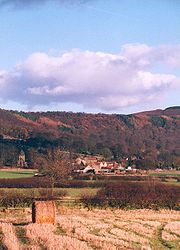
The district is named after the Hambleton Hills
, part of the North York Moors National Park, on the eastern edge of the district. This area is the subject of a national habitat protection scheme as articulated in the United Kingdom
's Biodiversity Action Plan
.
 Hambleton covers an area of 1,311.17
km² most of which, 1,254.90 km², is green space
. The district is named after the Hambleton Hills
, part of the North York Moors National Park, on the eastern edge of the district. This area is the subject of a national habitat protection scheme as articulated in the United Kingdom
's Biodiversity Action Plan
.
Population Size
1. Northallerton
2. Thirsk
3. Bedale
4. Easingwold
. In the 2001 census 83% of respondents identified their religion
as Christians above the national average for England
which was 71.74%. No other religion accounted for more than 0.2% of the population with the next two largest groups of respondents where those with no religion, at 10.40%, and who did not state a religion, at 6.14%.
showed that housing in Hambleton produced the 8th highest average carbon emissions in the country at 7,242 kg of carbon dioxide
per dwelling. Whilst this has come under some scrutiny, it is important to remember that due to the remote nature of the councils parishes (Great Langton
, Scorton etc.) carbon emissions are likely to be high.
Non-metropolitan district
Non-metropolitan districts, or colloquially shire districts, are a type of local government district in England. As created, they are sub-divisions of non-metropolitan counties in a so-called "two-tier" arrangement...
of North Yorkshire
North Yorkshire
North Yorkshire is a non-metropolitan or shire county located in the Yorkshire and the Humber region of England, and a ceremonial county primarily in that region but partly in North East England. Created in 1974 by the Local Government Act 1972 it covers an area of , making it the largest...
, England
England
England is a country that is part of the United Kingdom. It shares land borders with Scotland to the north and Wales to the west; the Irish Sea is to the north west, the Celtic Sea to the south west, with the North Sea to the east and the English Channel to the south separating it from continental...
. The main town and administrative centre is Northallerton
Northallerton
Northallerton is an affluent market town and civil parish in the Hambleton district of North Yorkshire, England. It lies in the Vale of Mowbray and at the northern end of the Vale of York. It has a population of 15,741 according to the 2001 census...
, and includes the market towns and major villages of Bedale
Bedale
Bedale is a market town and civil parish in the district of Hambleton, North Yorkshire, England. It lies north of Leeds, southwest of Middlesbrough, and south west of the county town of Northallerton...
, Thirsk
Thirsk
Thirsk is a small market town and civil parish in the Hambleton district of North Yorkshire, England. The local travel links are located a mile from the town centre to Thirsk railway station and to Durham Tees Valley Airport...
, Great Ayton
Great Ayton
Great Ayton is a village and civil parish in the Hambleton district of North Yorkshire on the edge of the North York Moors in England. The name Great Ayton is thought to derive from Ea-tun, tun meaning farm and 'ea' meaning river. It has a population of 4,570....
, Stokesley
Stokesley
Stokesley is a small market town and civil parish in the Hambleton district of North Yorkshire, England. It lies on the River Leven. Stokesley is located about two miles south of the boundary of the borough of Middlesbrough and ten miles south of Middlesbrough town centre. Stokesley is located...
and Easingwold
Easingwold
Easingwold is a small market town and a civil parish in North Yorkshire, England. It has a population of 4,233.It is located north of York, at the foot of the Howardian Hills....
.
The district was formed by the Local Government Act 1972
Local Government Act 1972
The Local Government Act 1972 is an Act of Parliament in the United Kingdom that reformed local government in England and Wales on 1 April 1974....
on 1 April 1974, as a merger of the urban district
Urban district
In the England, Wales and Ireland, an urban district was a type of local government district that covered an urbanised area. Urban districts had an elected Urban District Council , which shared local government responsibilities with a county council....
of Northallerton with Bedale Rural District, Easingwold Rural District, Northallerton Rural District, and part of Thirsk Rural District and Croft Rural District, all in the North Riding of Yorkshire
North Riding of Yorkshire
The North Riding of Yorkshire was one of the three historic subdivisions of the English county of Yorkshire, alongside the East and West Ridings. From the Restoration it was used as a Lieutenancy area. The three ridings were treated as three counties for many purposes, such as having separate...
.
The district is named after the Hambleton Hills
Hambleton Hills
The Hambleton Hills are a range of hills in North Yorkshire in the United Kingdom. They form the western edge of the North Yorkshire Moors but are separated from the moors by the valley of the River Rye...
, part of the North York Moors National Park, on the eastern edge of the district. This area is the subject of a national habitat protection scheme as articulated in the United Kingdom
United Kingdom
The United Kingdom of Great Britain and Northern IrelandIn the United Kingdom and Dependencies, other languages have been officially recognised as legitimate autochthonous languages under the European Charter for Regional or Minority Languages...
's Biodiversity Action Plan
Biodiversity Action Plan
A Biodiversity Action Plan is an internationally recognized program addressing threatened species and habitats and is designed to protect and restore biological systems. The original impetus for these plans derives from the 1992 Convention on Biological Diversity...
.
Geography
1 E9 m²
To help compare orders of magnitude of different geographical regions, we list here areas between 1,000 km2 and 10,000 km2. See also areas of other orders of magnitude.* areas less than 1000 km2* 1,000 km2 is equal to:...
km² most of which, 1,254.90 km², is green space
Natural environment
The natural environment encompasses all living and non-living things occurring naturally on Earth or some region thereof. It is an environment that encompasses the interaction of all living species....
. The district is named after the Hambleton Hills
Hambleton Hills
The Hambleton Hills are a range of hills in North Yorkshire in the United Kingdom. They form the western edge of the North Yorkshire Moors but are separated from the moors by the valley of the River Rye...
, part of the North York Moors National Park, on the eastern edge of the district. This area is the subject of a national habitat protection scheme as articulated in the United Kingdom
United Kingdom
The United Kingdom of Great Britain and Northern IrelandIn the United Kingdom and Dependencies, other languages have been officially recognised as legitimate autochthonous languages under the European Charter for Regional or Minority Languages...
's Biodiversity Action Plan
Biodiversity Action Plan
A Biodiversity Action Plan is an internationally recognized program addressing threatened species and habitats and is designed to protect and restore biological systems. The original impetus for these plans derives from the 1992 Convention on Biological Diversity...
.
Towns
- BedaleBedaleBedale is a market town and civil parish in the district of Hambleton, North Yorkshire, England. It lies north of Leeds, southwest of Middlesbrough, and south west of the county town of Northallerton...
- EasingwoldEasingwoldEasingwold is a small market town and a civil parish in North Yorkshire, England. It has a population of 4,233.It is located north of York, at the foot of the Howardian Hills....
- NorthallertonNorthallertonNorthallerton is an affluent market town and civil parish in the Hambleton district of North Yorkshire, England. It lies in the Vale of Mowbray and at the northern end of the Vale of York. It has a population of 15,741 according to the 2001 census...
- ThirskThirskThirsk is a small market town and civil parish in the Hambleton district of North Yorkshire, England. The local travel links are located a mile from the town centre to Thirsk railway station and to Durham Tees Valley Airport...
Population Size
1. Northallerton
2. Thirsk
3. Bedale
4. Easingwold
Demographics
In 2007 Hambleton had an estimated population of 86,900 an increase of 3.2% on the population of 84,200 recorded in the 2001 UK censusUnited Kingdom Census 2001
A nationwide census, known as Census 2001, was conducted in the United Kingdom on Sunday, 29 April 2001. This was the 20th UK Census and recorded a resident population of 58,789,194....
. In the 2001 census 83% of respondents identified their religion
Religion
Religion is a collection of cultural systems, belief systems, and worldviews that establishes symbols that relate humanity to spirituality and, sometimes, to moral values. Many religions have narratives, symbols, traditions and sacred histories that are intended to give meaning to life or to...
as Christians above the national average for England
England
England is a country that is part of the United Kingdom. It shares land borders with Scotland to the north and Wales to the west; the Irish Sea is to the north west, the Celtic Sea to the south west, with the North Sea to the east and the English Channel to the south separating it from continental...
which was 71.74%. No other religion accounted for more than 0.2% of the population with the next two largest groups of respondents where those with no religion, at 10.40%, and who did not state a religion, at 6.14%.
Energy policy
In May 2006, a report commissioned by British GasCentrica
Centrica plc is a multinational utility company, based in the United Kingdom but also with interests in North America. Centrica is the largest supplier of gas to domestic customers in the UK, and one of the largest suppliers of electricity, operating under the trading names "Scottish Gas" in...
showed that housing in Hambleton produced the 8th highest average carbon emissions in the country at 7,242 kg of carbon dioxide
Carbon dioxide
Carbon dioxide is a naturally occurring chemical compound composed of two oxygen atoms covalently bonded to a single carbon atom...
per dwelling. Whilst this has come under some scrutiny, it is important to remember that due to the remote nature of the councils parishes (Great Langton
Great Langton
Great Langton is a small village and civil parish in the district of Hambleton, North Yorkshire, England. The village lies on the B6271 road, between Scorton and Northallerton, on the northern bank of the River Swale and it was once known as Langton-upon-Swale....
, Scorton etc.) carbon emissions are likely to be high.