

Granite, Colorado
Encyclopedia
Granite is an unincorporated town
with a U.S. Post Office
in Chaffee County
, Colorado
, United States
. The zip code of Granite is 81228. According to the 2010 census, the population is 116.
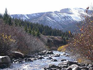 Granite is located at 39°02′38"N 106°15′44"W (39.043986,-106.262169), midway between Leadville to the north, and Buena Vista
to the south. The Arkansas River
, which once saw extensive placer mining
in the Colorado Gold Rush
days, runs through Granite. It is the sixth longest river in the US; the headwaters is 17 miles north in the Leadville area. Granite is located between the Mosquito Range
to the east and the Sawatch Range
to the west, and is within approximately 10 miles of two of the highest peaks in the contiguous United States
. To the northwest lies Mount Elbert
, the highest of the fourteeners in the Sawatch Range and second highest peak in the contiguous United States, and neighboring Mount Massive
is the third highest. Nearby Independence Pass
, at 12,100 feet (3,687 m), is the highest paved crossing of the Continental Divide
in the United States. The elevation, 9,012 ft (2,747 m), brings cool summers and cold winters to the area. . Winter temperatures frequently drop to -25 and -30 (USDA zone 4). Surrounded by moisture-robbing mountains, the climate is semiarid, though deep winter snows are common.
 The Pike's Peak Gold Rush that began in 1859 brought an unprecedented number of people into the Colorado Territory
. Among the earliest gold discoveries in Colorado were placer
deposits in early 1859 near the headwaters of the Arkansas River. In 1860, Cache Creek, a mining camp near Granite, became the first settlement of note with a population of about 300. By the following year, Granite, located on either side of the Arkansas river, exploded to a population of 3,000. The settlement included a three-mile stretch of river and extended two-miles up Cache Creek. In 1867 free quartz gold was discovered, a mill was built and in 1968 the county seat
was moved from the neighboring town of Dayton, near present-day Twin Lakes
but no longer in existence, to Granite.
1874 and 1875 brought the "Lake County War", a war over water rights, to Granite. The war reached its climax when members of the “Committee of Safety” killed Probate Judge Elias Dyer in his own courtroom. A vigilante
committee had been trying to rid the county of "lawbreakers" using illegal arrests, coerced confessions and forced exile as tools in its campaign. No one was ever convicted of Judge Dyer's murder. Murders were common, but convictions were not. More than one hundred homicides occurred during this period without a single conviction; it was almost impossible to get witnesses to swear to the killings.
The early prospectors included Horace Tabor who later to moved up the valley to Leadville where he was to find his fortune in the Colorado Silver Boom
that swept Leadville in 1879. In a much-publicized scandal Tabor divorced his wife and married young and beautiful Elizabeth "Baby Doe" McCourt
, twenty years his junior. The Tabors had two children, Lily and Silver Dollar. The Tabors lost their wealth when the price of silver dropped in 1893 and Tabor died in 1899 with a final request of Baby Doe that she maintain the claim to their silver mine. Baby Doe lived in squalid conditions in the tool shed of the mine for thirty years and was found dead in 1936.
gold strikes in Lake County, Granite held the position of county seat
, but in 1878 they lost out to booming silver-rich Leadville, 17 miles to the north. However, Granite did manage to remain the county seat, but not of Lake County. They redrew the county lines creating Chaffee County, with Granite as the county seat. But a year later an election was held resulting in a win for Buena Vista, 17 miles to the south of Granite, with 1,128 votes out of a total population of 1,200 (when women couldn’t vote).
Granite declared the election fraudulent and refused to give up its position, so late one night a group of men from Buena Vista took matters into their own hands.
The incident is described at the Buena Vista Heritage Museum:
 The upper Arkansas River valley, including the area around Granite, is hemmed in between high, sheer rock outcroppings of buff/pink-colored Precambrian
granite
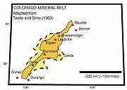
. Granite lies at the center of the Colorado Mineral Belt
, a 50 mile-wide strip that runs north and south for 300 miles. Mineralization of the CMB came primarily by way of intrusions of Tertiary Period magmas. The primary ores of the CMB were generally deposited as mixed metal sulfide veins containing pyrite
, galena
, sphalerite
, chalcopyrite
, and gold, silver, and copper.
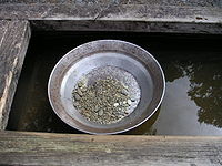
 During the last glacial period native gold was freed from the host rock and deposited along the ancient roaring Arkansas River bed - much larger than it is today due to the melting glacial runoff. Among the earliest gold discoveries in Colorado were placer
deposits in early 1859 at the headwaters of the Arkansas River near Granite. By late 1860 most of the streams had been prospected, and numerous gold placers were reported along the Arkansas River to Buena Vista and beyond. The deposits along the Arkansas River and Cache Creek near Granite probably were the most productive, producing about 10,000 troy ounces of gold.
Unlike the early days of the California Gold Rush
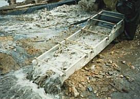
, very few large nuggets were ever found in the Colorado diggin's. A gold pan was adequate for finding "pay dirt", but to produce any amount of gold, sluice
boxes were built to separate the gold dust from the gravel. They were built on site from the material that was at hand and placed in the river current. The old sluice boxes were lined with raised obstructions that were placed in a vertical position to the flow of the current and when the gold-laden gravel was shoveled into the upper end of the sluice, the flow of water carried the material down the length of the box. The lighter gravel (tailings) would be carried down the entire length of the sluice and then discharged, but the heavier flakes of gold would settle and become trapped. Signs of placer mining up and down along the Arkansas river near Granite and the surrounding areas are in evidence by the many heaps of glacially-rounded granite boulders.
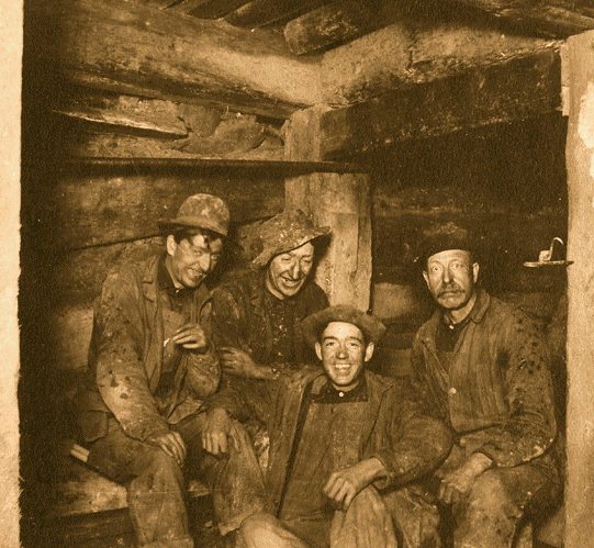
In many Colorado mining districts the easily discovered and worked placers were the first big strikes of a typical gold rush
. But the free gold supply in stream beds would quickly become depleted, and the initial phase would be followed by prospecting for veins of lode gold that were the original source of the placer gold. The hills above Granite are pockmarked with numerous old mining tunnels from hard rock mining
, evidence of the second stage of a gold rush cycle. Their neighbors in Leadville went on to discover silver, resulting in a silver rush
, but Granite never got that far. In just a few years their ore began to play out, and the town's population, once as high as 7000, began to decline.
, built in 1822, had a north fork up to Denver (founded in 1858), and by 1877 the Leadville Stagecoach Road was running from Canyon City, through Granite, Leadville, and north to Denver. Reliable transportation was important to deliver supplies for the growing communities, and the route was used more as a supply and mail route than for transportation of passengers. An old schedule from 1980 with the stage stops from Canyon City to Leadville shows that the trip was 126 miles and took 26 (jarring) hours. The distance to Granite was 108 miles and the fare was $13.50
Looking for traces of the old stage road one can still find the remains of bridges that crossed the Arkansas north of Buena Vista near the Midland railroad tunnels, from east to west at Pine Creek, and a final crossing to the east side of the Arkansas just north of Clear Creek. At low water levels, log supports of the rubble-filled abutments can still be seen. The stage road was built ten to fifteen years prior to the arrival of the rail roads, and it is likely that the heavily engineered rail routes overwhelmed the hand-built stage road wherever they met up. It's uncertain as to whether or not the stage road was abandoned as soon as the railroads reached Leadville, or if the route continued to be used by freight wagons and even early motor cars until better routes were available on the west side of the river where Highway 24 now runs. The stretch of old stage road that runs through Granite is surprisingly well-preserved and is used as a hiking/cycling trail.
and machine shops, and assay
offices as well. Without a local supply of coal they were using charcoal
as fuel, in fact, the charcoal industry in Leadville employed an estimated 3,000 people, three times the number of those working in the mines, and the forests were being rapidly depleted.
With the chance to control Leadville's newly discovered riches, both the D&RG and the Santa Fe set their sights on Leadville. They both rapidly laid track, but when they reached the Grand Canyon of the Arkansas (Royal Gorge) there was not room for both of them. Over a hundred years later the D&RG would comment (on their website):
"The Royal Gorge Route has, quite possibly, one of strangest histories of the entire Rio Grande system." The details of the "Royal Gorge War" can be read at the Royal Gorge Route Railroad
Wikipedia article. After months of legal hassling, construction resumed and the D&RGW made it to Granite and reached Leadville on July 20, 1880. The line remained narrow gauge
until 1888, when it became one of the first routes converted to dual gauge. In part this was done to handle the heavy freight coming out of Leadville, but primarily it was done to provide a standard gauge route west in order to compete effectively with the ever-expanding Colorado Midland.
, incorporated in 1883, was the first standard gauge
railroad built over the Continental Divide
in Colorado. It ran from Colorado Springs through Granite and Leadville, crossed the divide at Hagerman Pass
, and went on to Aspen
and Grand Junction. They had a more difficult time running their track because the routes that were the easiest places to lay rails had already been taken by the other railroads. The second problem was that the Colorado Midland was a standard gauge, so it needed more space to run the tracks. Curves were broader, bridges and tunnels had to be larger, and the total expense was considerably greater. Service was discontinued in 1918 due to financial difficulties. The old Midland grade is still evident in Granite and sections of bridge can be seen about two miles south. Four tunnels still exist farther south closer to Buena Vista.
So, it would seem that some things have not changed much since 1925.
Winfield was the largest settlement. In 1890 the estimated population is listed as fifteen hundred, but it can be assumed that hundreds more lived in the surrounding area. Winfield included three saloons, three stores, a post office, two hotels, a boarding house, mill, smelter, ore concentrator, church, and a school. The last ore was hauled out by stage in 1918. Several restored buildings remain, including the school.
Vicksburg was founded in 1867 after prospectors from Leadville camping out in the Clear Creek Canyon lost their burros. The burros had wandered down the creek and when the miners found their pack animals, they discovered gold in the creek bed as well. In its heyday, Vicksburg had a post office, school, blacksmith
, two hotels, two billiard halls, several saloons, a general store, an assay
office, and a livery stable. Early miners packed in Balm of Gilead (balsam poplar
) trees on the backs of burros and planted them to line the street. The early settlers likely used the sticky sap of the trees to make a medicinal salve used for both animals and humans alike. The trees still stand today and are watered by ditches leading from Vicksburg Creek into the town. The ditches were dug on either side of the street to provide a water system; wooden boxes were built in the ditches to keep food cold and provide water to fight fires. A daily stage ran from Vicksburg to Granite; the fare was $1.50.
Located near Vicksburg but dating to the 1930s is the Crescent Moly Mine #100 and Mining Camp. However, the Crescent Moly was not a gold mine but was associated with the molybdenum
boom and the nearby Climax mine
phenomenon. Both Vicksburg and the Crescent Moly Mine are listed on the National Register of Historic Places
.
A mile further down the valley Pine Creek empties into the Arkansas and evidence remains of prospecting and mining in this area as well. The Colorado Historical Society lists the Littlejohn mine camp on the north bank of Pine Creek:
is said to be that of an unknown 19-year-old male who died of pneumonia in 1860; the first marked burial is dated 1878. The cemetery is still in use.
One of the earliest graves is that of Pat Casey, a gandy dancer
(section crew worder) who was murdered in 1888 when his throat was slit by Niccolo Feminello, also a railroad worker. Feminello was convicted of the murder and became infamous as being the only "legal hanging" to take place in Chaffee
County. Feminello was buried in the Mt Olivet cemetery in Buena Vista after his execution behind the Buena Vista court house.
Several graves contain the remains of the last of the old-time miners that still lived in the hills surrounding Granite. Charles Franklin, born in 1868 in Sweden and immigrated to the U.S.
in 1888; died in 1950. Known locally as "Old Man Franklin", he lived in a one-room log cabin with a dirt floor located on the Arkansas River near Clear Creek, just south of Granite. Like the other "last of their breed" that were soon to follow him in death, he was unmarried and lived alone. The following year Frank Churchill, another never-married miner, was found dead in Clear Creek near his cabin; it was some time before his body was discovered.
Dave Jardine, another old miner, lived in a log cabin situated on Pine Creek, south of Granite, till his death in 1953. Jardine was perhaps a little odd - he always carried a "doodlebug", a pendulum
similar to that used for dousing
, to tell the future or just for advise. Dave, or "Stinky Dave" as he was called, loved dogs and had 5 or 6 strays that he kept in his cabin at night. He had deep chronic venous ulcer
s on both ankles that may have been the cause of his bad odor, and may well have been the cause of his death. At any rate, when authorities discovered him he had been eaten by his dogs after he had died alone in his cabin.
 Little remains of Granite's past. In the 1950s a Colorado couple ran a gold panning tourist attraction they named "Gold Camp", just south of town at the point that Pine Creek runs into the Arkansas. By 1955, the Granite school enrollment had dwindled to only thirteen and the school was closed. The railroad ended service in the 1980s. Chaffee County lists the school and the Denver & Rio Grande railroad building and several other still-standing buildings including a blacksmith-livery and a stage stop as sites of historical interest.
Today this area draws whitewater rafting enthusiasts. The rapids were created by a massive glacial flood which spread boulders down the river for over fifty miles. The whitewater area starts in the "Granite Gorge" with class IV rapids and the river rapidly drops to the steepest point at "Pine Creek Rapids", class V. Situated within the San Isabel National Forest and surrounded by three wilderness areas, Granite is also a popular hiking area. The Mount Massive Wilderness
area lies a few miles north, the Buffalo Peaks Wilderness
is to the east within the Mosquito Range, and the Collegiate Peaks Wilderness
is to the west within the Sawatch Range.
For years only one business remained open, the Granite General Store, however it closed in 2007. The building was originally an 1880s bunk house for railroad workers. Currently there are only eight year-round residents in Granite. Most people, even "locals", pass through Granite unaware of its historical past.
, gambler, gunfighter, and dentist of the American Old West and most remembered for his involvement in the 1881 Gunfight at the O.K. Corral
, left Arizona by rail and then took the Leadville stage from Buena Vista , north through Granite, and on to Leadville in 1882.
In 1954, 7th grade Granite student Juliann Horvath, a year young for her class because she had started school a year early, won the Chaffee County combined 7th and 8th grade spelling bee
. Juliann was one of only three Granite 7th grade students, and the total school enrollment that year was less than twenty.
Unincorporated area
In law, an unincorporated area is a region of land that is not a part of any municipality.To "incorporate" in this context means to form a municipal corporation, a city, town, or village with its own government. An unincorporated community is usually not subject to or taxed by a municipal government...
with a U.S. Post Office
United States Postal Service
The United States Postal Service is an independent agency of the United States government responsible for providing postal service in the United States...
in Chaffee County
Chaffee County, Colorado
Chaffee County is one of the 64 counties of the state of Colorado of the United States. The county population was 16,242 at U.S. Census 2000. The county seat is Salida.-History:...
, Colorado
Colorado
Colorado is a U.S. state that encompasses much of the Rocky Mountains as well as the northeastern portion of the Colorado Plateau and the western edge of the Great Plains...
, United States
United States
The United States of America is a federal constitutional republic comprising fifty states and a federal district...
. The zip code of Granite is 81228. According to the 2010 census, the population is 116.
Geography and climate
Buena Vista
Buena Vista, meaning "good view" in Spanish, may refer to:*Buena Vista , a Walt Disney trademark*Buena Vista Social Club , a Cuban music club plus an album and film inspired by the club...
to the south. The Arkansas River
Arkansas River
The Arkansas River is a major tributary of the Mississippi River. The Arkansas generally flows to the east and southeast as it traverses the U.S. states of Colorado, Kansas, Oklahoma, and Arkansas. The river's initial basin starts in the Western United States in Colorado, specifically the Arkansas...
, which once saw extensive placer mining
Placer mining
Placer mining is the mining of alluvial deposits for minerals. This may be done by open-pit or by various surface excavating equipment or tunneling equipment....
in the Colorado Gold Rush
Colorado Gold Rush
The Pike's Peak Gold Rush was the boom in gold prospecting and mining in the Pike's Peak Country of western Kansas Territory and southwestern Nebraska Territory of the United States that began in July 1858 and lasted until roughly the creation of the Colorado Territory on February 28, 1861...
days, runs through Granite. It is the sixth longest river in the US; the headwaters is 17 miles north in the Leadville area. Granite is located between the Mosquito Range
Mosquito Range
The Mosquito Range is a high mountain range in the Rocky Mountains of central Colorado in the United States. The peaks of the range form a ridge running north-south for approximately 40 miles from southern Summit County on the north end, then along the boundary between Lake and Park counties...
to the east and the Sawatch Range
Sawatch Range
The Sawatch Range is a mountain range in central Colorado which includes eight of the twenty highest peaks in the Rocky Mountains, including Mount Elbert, at elevation, the highest peak in the Rockies....
to the west, and is within approximately 10 miles of two of the highest peaks in the contiguous United States
Contiguous United States
The contiguous United States are the 48 U.S. states on the continent of North America that are south of Canada and north of Mexico, plus the District of Columbia....
. To the northwest lies Mount Elbert
Mount Elbert
Mount Elbert is the highest peak in the Rocky Mountains of North America, at , the highest of the fourteeners in Colorado, and the high point of the Sawatch Range. It is located in Lake County, approximately southwest of Leadville...
, the highest of the fourteeners in the Sawatch Range and second highest peak in the contiguous United States, and neighboring Mount Massive
Mount Massive
Mount Massive is a fourteener in the Sawatch Range of the US State of Colorado. It is the second tallest peak in Colorado, edging out the third highest, Mount Harvard, by seven feet, and lower than Mount Elbert by . It is the third highest peak in the contiguous United States...
is the third highest. Nearby Independence Pass
Independence Pass (Colorado)
Independence Pass, elevation , is a high mountain pass in the Rocky Mountains of central Colorado in the United States.The pass crosses the ridge of the Sawatch Range between Aspen and Leadville, on the border between Pitkin and Lake counties, and is within the White River National Forest...
, at 12,100 feet (3,687 m), is the highest paved crossing of the Continental Divide
Continental Divide
The Continental Divide of the Americas, or merely the Continental Gulf of Division or Great Divide, is the name given to the principal, and largely mountainous, hydrological divide of the Americas that separates the watersheds that drain into the Pacific Ocean from those river systems that drain...
in the United States. The elevation, 9,012 ft (2,747 m), brings cool summers and cold winters to the area. . Winter temperatures frequently drop to -25 and -30 (USDA zone 4). Surrounded by moisture-robbing mountains, the climate is semiarid, though deep winter snows are common.
History
Colorado Territory
The Territory of Colorado was an organized incorporated territory of the United States that existed from February 28, 1861, until August 1, 1876, when it was admitted to the Union as the State of Colorado....
. Among the earliest gold discoveries in Colorado were placer
Placer
Placer may refer to one of the following:*Placer deposit*Placer sheep*Placer mining*Placer, rugby league football role.Geographical names:* Placer, Masbate, Philippines* Placer, Surigao del Norte, Philippines...
deposits in early 1859 near the headwaters of the Arkansas River. In 1860, Cache Creek, a mining camp near Granite, became the first settlement of note with a population of about 300. By the following year, Granite, located on either side of the Arkansas river, exploded to a population of 3,000. The settlement included a three-mile stretch of river and extended two-miles up Cache Creek. In 1867 free quartz gold was discovered, a mill was built and in 1968 the county seat
County seat
A county seat is an administrative center, or seat of government, for a county or civil parish. The term is primarily used in the United States....
was moved from the neighboring town of Dayton, near present-day Twin Lakes
Twin Lakes
-Communities:Canada*Twin Lakes Indonesia* Twin Lakes , aka Danau Kembar, West SumatraUnited Kingdom*Twin Lakes, a family theme park in Melton Mowbray, LeicestershireUnited States...
but no longer in existence, to Granite.
1874 and 1875 brought the "Lake County War", a war over water rights, to Granite. The war reached its climax when members of the “Committee of Safety” killed Probate Judge Elias Dyer in his own courtroom. A vigilante
Vigilante
A vigilante is a private individual who legally or illegally punishes an alleged lawbreaker, or participates in a group which metes out extralegal punishment to an alleged lawbreaker....
committee had been trying to rid the county of "lawbreakers" using illegal arrests, coerced confessions and forced exile as tools in its campaign. No one was ever convicted of Judge Dyer's murder. Murders were common, but convictions were not. More than one hundred homicides occurred during this period without a single conviction; it was almost impossible to get witnesses to swear to the killings.
The early prospectors included Horace Tabor who later to moved up the valley to Leadville where he was to find his fortune in the Colorado Silver Boom
Colorado Silver Boom
The Colorado Silver Boom was a dramatic expansionist period of silver mining activity in the U.S. state of Colorado in the late 19th century. The boom started in 1879 with the discovery of silver at Leadville...
that swept Leadville in 1879. In a much-publicized scandal Tabor divorced his wife and married young and beautiful Elizabeth "Baby Doe" McCourt
Baby Doe Tabor
Elizabeth McCourt Tabor , better known as Baby Doe, was the second wife of pioneer Colorado businessman Horace Tabor. Horace Tabor's divorce and subsequent marriage to the young and beautiful Baby Doe caused a major scandal in 1880s Colorado...
, twenty years his junior. The Tabors had two children, Lily and Silver Dollar. The Tabors lost their wealth when the price of silver dropped in 1893 and Tabor died in 1899 with a final request of Baby Doe that she maintain the claim to their silver mine. Baby Doe lived in squalid conditions in the tool shed of the mine for thirty years and was found dead in 1936.
County Seat
Until 1879 the village of Granite was located in Lake County, once one of the two largest of the Colorado Territory’s original 17 counties. As the site of some of the richest placerPlacer
Placer may refer to one of the following:*Placer deposit*Placer sheep*Placer mining*Placer, rugby league football role.Geographical names:* Placer, Masbate, Philippines* Placer, Surigao del Norte, Philippines...
gold strikes in Lake County, Granite held the position of county seat
County seat
A county seat is an administrative center, or seat of government, for a county or civil parish. The term is primarily used in the United States....
, but in 1878 they lost out to booming silver-rich Leadville, 17 miles to the north. However, Granite did manage to remain the county seat, but not of Lake County. They redrew the county lines creating Chaffee County, with Granite as the county seat. But a year later an election was held resulting in a win for Buena Vista, 17 miles to the south of Granite, with 1,128 votes out of a total population of 1,200 (when women couldn’t vote).
Granite declared the election fraudulent and refused to give up its position, so late one night a group of men from Buena Vista took matters into their own hands.
The incident is described at the Buena Vista Heritage Museum:
Buena Vistans voted to make their town the county seat, but Granite refused to give up the records. So a group of men lead by Ernest Wilbur "borrowed" a locomotive and flat car and went up to Granite late on the night of November 12, 1880. The men built a siding to the Granite Courthouse and kicked in the door.
Sheriff John Mear and his wife investigated the noise and were forced at gunpoint to watch the removal of all the county records by the Buena Vista men. Furniture was unbolted from the floor, including the railing. Even the heat stove, with embers remaining in it from the day's use, was loaded onto the flatcar.
Geology and mining
Precambrian
The Precambrian is the name which describes the large span of time in Earth's history before the current Phanerozoic Eon, and is a Supereon divided into several eons of the geologic time scale...
granite
Granite
Granite is a common and widely occurring type of intrusive, felsic, igneous rock. Granite usually has a medium- to coarse-grained texture. Occasionally some individual crystals are larger than the groundmass, in which case the texture is known as porphyritic. A granitic rock with a porphyritic...
. Granite lies at the center of the Colorado Mineral Belt
Colorado Mineral Belt
The Colorado Mineral Belt is an area with abundant ore deposits. The area stretches north-east from the La Plata Mountains in Southwestern Colorado to the Front Range near Boulder, Colorado...
, a 50 mile-wide strip that runs north and south for 300 miles. Mineralization of the CMB came primarily by way of intrusions of Tertiary Period magmas. The primary ores of the CMB were generally deposited as mixed metal sulfide veins containing pyrite
Pyrite
The mineral pyrite, or iron pyrite, is an iron sulfide with the formula FeS2. This mineral's metallic luster and pale-to-normal, brass-yellow hue have earned it the nickname fool's gold because of its resemblance to gold...
, galena
Galena
Galena is the natural mineral form of lead sulfide. It is the most important lead ore mineral.Galena is one of the most abundant and widely distributed sulfide minerals. It crystallizes in the cubic crystal system often showing octahedral forms...
, sphalerite
Sphalerite
Sphalerite is a mineral that is the chief ore of zinc. It consists largely of zinc sulfide in crystalline form but almost always contains variable iron. When iron content is high it is an opaque black variety, marmatite. It is usually found in association with galena, pyrite, and other sulfides...
, chalcopyrite
Chalcopyrite
Chalcopyrite is a copper iron sulfide mineral that crystallizes in the tetragonal system. It has the chemical composition CuFeS2. It has a brassy to golden yellow color and a hardness of 3.5 to 4 on the Mohs scale. Its streak is diagnostic as green tinged black.On exposure to air, chalcopyrite...
, and gold, silver, and copper.
Placer
Placer may refer to one of the following:*Placer deposit*Placer sheep*Placer mining*Placer, rugby league football role.Geographical names:* Placer, Masbate, Philippines* Placer, Surigao del Norte, Philippines...
deposits in early 1859 at the headwaters of the Arkansas River near Granite. By late 1860 most of the streams had been prospected, and numerous gold placers were reported along the Arkansas River to Buena Vista and beyond. The deposits along the Arkansas River and Cache Creek near Granite probably were the most productive, producing about 10,000 troy ounces of gold.
Unlike the early days of the California Gold Rush
California Gold Rush
The California Gold Rush began on January 24, 1848, when gold was found by James W. Marshall at Sutter's Mill in Coloma, California. The first to hear confirmed information of the gold rush were the people in Oregon, the Sandwich Islands , and Latin America, who were the first to start flocking to...
, very few large nuggets were ever found in the Colorado diggin's. A gold pan was adequate for finding "pay dirt", but to produce any amount of gold, sluice
Sluice
A sluice is a water channel that is controlled at its head by a gate . For example, a millrace is a sluice that channels water toward a water mill...
boxes were built to separate the gold dust from the gravel. They were built on site from the material that was at hand and placed in the river current. The old sluice boxes were lined with raised obstructions that were placed in a vertical position to the flow of the current and when the gold-laden gravel was shoveled into the upper end of the sluice, the flow of water carried the material down the length of the box. The lighter gravel (tailings) would be carried down the entire length of the sluice and then discharged, but the heavier flakes of gold would settle and become trapped. Signs of placer mining up and down along the Arkansas river near Granite and the surrounding areas are in evidence by the many heaps of glacially-rounded granite boulders.
In many Colorado mining districts the easily discovered and worked placers were the first big strikes of a typical gold rush
Gold rush
A gold rush is a period of feverish migration of workers to an area that has had a dramatic discovery of gold. Major gold rushes took place in the 19th century in Australia, Brazil, Canada, South Africa, and the United States, while smaller gold rushes took place elsewhere.In the 19th and early...
. But the free gold supply in stream beds would quickly become depleted, and the initial phase would be followed by prospecting for veins of lode gold that were the original source of the placer gold. The hills above Granite are pockmarked with numerous old mining tunnels from hard rock mining
Hard rock mining
Underground hard rock mining refers to various underground mining techniques used to excavate hard minerals, mainly those containing metals such as ore containing gold, silver, iron, copper, zinc, nickel and lead, but also involves using the same techniques for excavating ores of gems such as...
, evidence of the second stage of a gold rush cycle. Their neighbors in Leadville went on to discover silver, resulting in a silver rush
Silver rush
A Silver rush is the silver-mining equivalent of a gold rush.Notable silver rushes have taken place in Mexico, Argentina, the United States , and Canada...
, but Granite never got that far. In just a few years their ore began to play out, and the town's population, once as high as 7000, began to decline.
Leadville Stagecoach Road
The earliest mode of transportation used by the growing number of settlers in Granite and the surrounding area was horseback and pack mules or burros. The Santa Fe TrailSanta Fe Trail
The Santa Fe Trail was a 19th-century transportation route through central North America that connected Missouri with Santa Fe, New Mexico. Pioneered in 1822 by William Becknell, it served as a vital commercial and military highway until the introduction of the railroad to Santa Fe in 1880...
, built in 1822, had a north fork up to Denver (founded in 1858), and by 1877 the Leadville Stagecoach Road was running from Canyon City, through Granite, Leadville, and north to Denver. Reliable transportation was important to deliver supplies for the growing communities, and the route was used more as a supply and mail route than for transportation of passengers. An old schedule from 1980 with the stage stops from Canyon City to Leadville shows that the trip was 126 miles and took 26 (jarring) hours. The distance to Granite was 108 miles and the fare was $13.50
Looking for traces of the old stage road one can still find the remains of bridges that crossed the Arkansas north of Buena Vista near the Midland railroad tunnels, from east to west at Pine Creek, and a final crossing to the east side of the Arkansas just north of Clear Creek. At low water levels, log supports of the rubble-filled abutments can still be seen. The stage road was built ten to fifteen years prior to the arrival of the rail roads, and it is likely that the heavily engineered rail routes overwhelmed the hand-built stage road wherever they met up. It's uncertain as to whether or not the stage road was abandoned as soon as the railroads reached Leadville, or if the route continued to be used by freight wagons and even early motor cars until better routes were available on the west side of the river where Highway 24 now runs. The stretch of old stage road that runs through Granite is surprisingly well-preserved and is used as a hiking/cycling trail.
Denver & Rio Grande West
In 1870 the Denver Pacific Railroad was built, providing Denver with rail transport to Cheyenne, Wyoming. Tracks were rapidly being laid in southern Colorado as the Denver & Rio Grande Western and the Atchison, Topeka & Santa Fe fought for control of newly discovered mineral and coal deposits and ranching and farming areas. But the 1878 silver boom in Leadville changed everything, and by 1879 the rush for Leadville, 17 miles to the north of Granite, was on. With the boom, Leadville had rapidly become the third largest city in Colorado and the newly-made millionaires had money and they wanted to spend it. Furthermore, they needed transport for their silver ore to the smelters in Denver or coal-rich southern Colorado, or a way to transport the coal from the southern coal mines to the upper Arkansas to fuel not only smelters, but blacksmithBlacksmith
A blacksmith is a person who creates objects from wrought iron or steel by forging the metal; that is, by using tools to hammer, bend, and cut...
and machine shops, and assay
Assay
An assay is a procedure in molecular biology for testing or measuring the activity of a drug or biochemical in an organism or organic sample. A quantitative assay may also measure the amount of a substance in a sample. Bioassays and immunoassays are among the many varieties of specialized...
offices as well. Without a local supply of coal they were using charcoal
Charcoal
Charcoal is the dark grey residue consisting of carbon, and any remaining ash, obtained by removing water and other volatile constituents from animal and vegetation substances. Charcoal is usually produced by slow pyrolysis, the heating of wood or other substances in the absence of oxygen...
as fuel, in fact, the charcoal industry in Leadville employed an estimated 3,000 people, three times the number of those working in the mines, and the forests were being rapidly depleted.
With the chance to control Leadville's newly discovered riches, both the D&RG and the Santa Fe set their sights on Leadville. They both rapidly laid track, but when they reached the Grand Canyon of the Arkansas (Royal Gorge) there was not room for both of them. Over a hundred years later the D&RG would comment (on their website):
"The Royal Gorge Route has, quite possibly, one of strangest histories of the entire Rio Grande system." The details of the "Royal Gorge War" can be read at the Royal Gorge Route Railroad
Royal Gorge Route Railroad
The Royal Gorge Route Railroad is a heritage railroad located in Cañon City, Colorado. The railroad transits the Royal Gorge on a 2-hour scenic and historic train ride along what is considered to be the most famous portion of the former Denver and Rio Grande Western Railroad...
Wikipedia article. After months of legal hassling, construction resumed and the D&RGW made it to Granite and reached Leadville on July 20, 1880. The line remained narrow gauge
Narrow gauge
A narrow gauge railway is a railway that has a track gauge narrower than the of standard gauge railways. Most existing narrow gauge railways have gauges of between and .- Overview :...
until 1888, when it became one of the first routes converted to dual gauge. In part this was done to handle the heavy freight coming out of Leadville, but primarily it was done to provide a standard gauge route west in order to compete effectively with the ever-expanding Colorado Midland.
Colorado Midland Railway
The Colorado Midland RailwayColorado Midland Railway
The Colorado Midland Railway , incorporated in 1883, was the first standard gauge railroad built over the Continental Divide in Colorado. It ran from Colorado Springs to Leadville and through the divide at Hagerman Pass to Glenwood Springs and Grand Junction....
, incorporated in 1883, was the first standard gauge
Standard gauge
The standard gauge is a widely-used track gauge . Approximately 60% of the world's existing railway lines are built to this gauge...
railroad built over the Continental Divide
Continental Divide
The Continental Divide of the Americas, or merely the Continental Gulf of Division or Great Divide, is the name given to the principal, and largely mountainous, hydrological divide of the Americas that separates the watersheds that drain into the Pacific Ocean from those river systems that drain...
in Colorado. It ran from Colorado Springs through Granite and Leadville, crossed the divide at Hagerman Pass
Hagerman Pass
Hagerman Pass, elevation , is a high mountain pass that crosses the continental divide in the Rocky Mountains of central Colorado in the United States.The pass was named for James J. Hagerman, builder of the Colorado Midland Railroad...
, and went on to Aspen
Aspen
Populus section Populus, of the Populus genus, includes the aspen trees and the white poplar Populus alba. The five typical aspens are all native to cold regions with cool summers, in the north of the Northern Hemisphere, extending south at high altitudes in the mountains. The White Poplar, by...
and Grand Junction. They had a more difficult time running their track because the routes that were the easiest places to lay rails had already been taken by the other railroads. The second problem was that the Colorado Midland was a standard gauge, so it needed more space to run the tracks. Curves were broader, bridges and tunnels had to be larger, and the total expense was considerably greater. Service was discontinued in 1918 due to financial difficulties. The old Midland grade is still evident in Granite and sections of bridge can be seen about two miles south. Four tunnels still exist farther south closer to Buena Vista.
Granite train wreck
On August 20, 1925, there was a head-on collision between two passenger trains on the Denver & Rio Grande Western Railroad near Granite, which resulted in 2 deaths and the injury of 107. The wreck was found to be the result of human error and a blistering report followed:- "It would be difficult to imagine a more inherently dangerous system, or lack of system, for the operation of trains under the trains under [sic] method of operation than that which appears to exist on this railroad. The disastrous results usually attendant upon careless handling of train orders are well illustrated in the present case, and the number and character of the violations of the rules, governing the handling of train orders raises a question as to whether the operating officials of this railroad have a proper appreciation of the responsibilities of their positions. While the immediate cause may be found to rest with the failure of some individual occupying a comparatively minor position, those responsible for the general conditions resulting in such failure occupy higher positions. They have the duty first to provide safe and adequate rules, for the operation of trains and then to enforce obedience to those rules, on the part of all concerned. This was not done in this ease, [sic] and for their failure they are equally responsible for the occurrence of this accident."
So, it would seem that some things have not changed much since 1925.
Ghost towns
While Granite is a ghost of what it once was, what with both a railroad and a major highway running through it has survived the years. However, many old ghost towns remain in the hills surrounding Granite. As the prospectors searched for gold, every Arkansas River tributary was a potential gold mining site and a chance to strike it rich. About two miles south of Granite, Clear Creek empties into the Arkansas River. Although prospecting took place in this area as early as 1867 when the gravel bar reaching out into the Arkansas was found to be rich in placer gold, the real activity didn't take off until 1879 when the canyon exploded with mines everywhere. A report from that time relates: "The Free Republic [mine] was the first location made in this district, having been discovered in July, 1879. A tunnel has been run 85 feet, showing 3 feet of mineral in the breast, galena and copper, assays ranging from 10 to 131 ounces. For a distance of 49 feet the tunnel has been running through a horse [a block of rock interrupting a vein and containing no minerals], but the pay vein was struck and proved to be nearly 20 feet wide." This early report goes on to list the colorfully-named mines of that time: The Mint, Prince Albert, Thunderbolt, Sixteen String Jack, Sunrise, Orphan Boy, Bluebird, Siamese Chief, Minnehaha, Silver Crop, Prize, Cinderella, Tiger, Birdie Boy, Buckeye State, Eagle Bird, and Terrible. A later report related that the four major mines were the Tasmania, the Fortune, the Banker and the Swiss Boy, so it would appear that most mines just did not "pan out". The towns of Beaver City, Vicksburg, Rockdale/Silverdale, Winfield, Hamilton, and others, once hives of activity, have either totally disappeared or remain primarily as ghost towns with only a few remaining buildings.Winfield was the largest settlement. In 1890 the estimated population is listed as fifteen hundred, but it can be assumed that hundreds more lived in the surrounding area. Winfield included three saloons, three stores, a post office, two hotels, a boarding house, mill, smelter, ore concentrator, church, and a school. The last ore was hauled out by stage in 1918. Several restored buildings remain, including the school.
Vicksburg was founded in 1867 after prospectors from Leadville camping out in the Clear Creek Canyon lost their burros. The burros had wandered down the creek and when the miners found their pack animals, they discovered gold in the creek bed as well. In its heyday, Vicksburg had a post office, school, blacksmith
Blacksmith
A blacksmith is a person who creates objects from wrought iron or steel by forging the metal; that is, by using tools to hammer, bend, and cut...
, two hotels, two billiard halls, several saloons, a general store, an assay
Assay
An assay is a procedure in molecular biology for testing or measuring the activity of a drug or biochemical in an organism or organic sample. A quantitative assay may also measure the amount of a substance in a sample. Bioassays and immunoassays are among the many varieties of specialized...
office, and a livery stable. Early miners packed in Balm of Gilead (balsam poplar
Balsam poplar
The balsam poplars — also known as Populus sect. Tacamahaca — are a group of about 10 species of poplars, indigenous to North America and eastern Asia, distinguished by the balsam scent of their buds, the whitish undersides of their leaves, and the leaf petiole being round in cross-section...
) trees on the backs of burros and planted them to line the street. The early settlers likely used the sticky sap of the trees to make a medicinal salve used for both animals and humans alike. The trees still stand today and are watered by ditches leading from Vicksburg Creek into the town. The ditches were dug on either side of the street to provide a water system; wooden boxes were built in the ditches to keep food cold and provide water to fight fires. A daily stage ran from Vicksburg to Granite; the fare was $1.50.
Located near Vicksburg but dating to the 1930s is the Crescent Moly Mine #100 and Mining Camp. However, the Crescent Moly was not a gold mine but was associated with the molybdenum
Molybdenum
Molybdenum , is a Group 6 chemical element with the symbol Mo and atomic number 42. The name is from Neo-Latin Molybdaenum, from Ancient Greek , meaning lead, itself proposed as a loanword from Anatolian Luvian and Lydian languages, since its ores were confused with lead ores...
boom and the nearby Climax mine
Climax mine
The Climax mine, located in Climax, Colorado, United States, was a major molybdenum mine in Lake and Summit counties, Colorado. In its heyday, the Climax mine was the largest molybdenum mine in the world, and for many years it supplied three-fourths of the world's supply of molbdenum...
phenomenon. Both Vicksburg and the Crescent Moly Mine are listed on the National Register of Historic Places
National Register of Historic Places
The National Register of Historic Places is the United States government's official list of districts, sites, buildings, structures, and objects deemed worthy of preservation...
.
A mile further down the valley Pine Creek empties into the Arkansas and evidence remains of prospecting and mining in this area as well. The Colorado Historical Society lists the Littlejohn mine camp on the north bank of Pine Creek:
- North bank of Pine Creek, vicinity of Granite
- National Register 12/27/1978, 5CF.138
- Located in the Pine Creek mining district, structures in the complex include a cabin, a burro shed/bunk house, a forgeForgeA forge is a hearth used for forging. The term "forge" can also refer to the workplace of a smith or a blacksmith, although the term smithy is then more commonly used.The basic smithy contains a forge, also known as a hearth, for heating metals...
, and several related outbuildings. All date from the 1880s and are constructed of hand hewn logs with A and V joints. Low pitch gabled roofs were made of logs, mud, dirt, and grass. Such intact examples of early log mining camps are rare as many were quickly abandoned or replaced with wood frame or masonry structures. Henry Littlejohn, who acquired the property in 1920 and lived and worked there until his death in 1952, is credited with maintaining the integrity of the complex.
Granite Cemetery
The Granite Cemetery, also known as the Cache Creek Cemetery, is located about one and one-half miles west of Granite. The earliest known burialis said to be that of an unknown 19-year-old male who died of pneumonia in 1860; the first marked burial is dated 1878. The cemetery is still in use.
One of the earliest graves is that of Pat Casey, a gandy dancer
Gandy dancer
Gandy dancer is a slang term used for early railroad workers who laid and maintained railroad tracks in the years before the work was done by machines....
(section crew worder) who was murdered in 1888 when his throat was slit by Niccolo Feminello, also a railroad worker. Feminello was convicted of the murder and became infamous as being the only "legal hanging" to take place in Chaffee
County. Feminello was buried in the Mt Olivet cemetery in Buena Vista after his execution behind the Buena Vista court house.
Several graves contain the remains of the last of the old-time miners that still lived in the hills surrounding Granite. Charles Franklin, born in 1868 in Sweden and immigrated to the U.S.
in 1888; died in 1950. Known locally as "Old Man Franklin", he lived in a one-room log cabin with a dirt floor located on the Arkansas River near Clear Creek, just south of Granite. Like the other "last of their breed" that were soon to follow him in death, he was unmarried and lived alone. The following year Frank Churchill, another never-married miner, was found dead in Clear Creek near his cabin; it was some time before his body was discovered.
Dave Jardine, another old miner, lived in a log cabin situated on Pine Creek, south of Granite, till his death in 1953. Jardine was perhaps a little odd - he always carried a "doodlebug", a pendulum
Pendulum
A pendulum is a weight suspended from a pivot so that it can swing freely. When a pendulum is displaced from its resting equilibrium position, it is subject to a restoring force due to gravity that will accelerate it back toward the equilibrium position...
similar to that used for dousing
Dousing
Dousing is the practice of making something or someone wet by throwing liquid over them, e.g., by pouring water, generally cold, over oneself. A related practice is ice swimming. Some consider cold water dousing to be a form of asceticism....
, to tell the future or just for advise. Dave, or "Stinky Dave" as he was called, loved dogs and had 5 or 6 strays that he kept in his cabin at night. He had deep chronic venous ulcer
Venous ulcer
Venous ulcers are wounds that are thought to occur due to improper functioning of venous valves, usually of the legs. They are the major cause of chronic wounds, occurring in 70% to 90% of chronic wound cases...
s on both ankles that may have been the cause of his bad odor, and may well have been the cause of his death. At any rate, when authorities discovered him he had been eaten by his dogs after he had died alone in his cabin.
Granite today
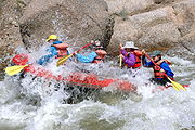
Today this area draws whitewater rafting enthusiasts. The rapids were created by a massive glacial flood which spread boulders down the river for over fifty miles. The whitewater area starts in the "Granite Gorge" with class IV rapids and the river rapidly drops to the steepest point at "Pine Creek Rapids", class V. Situated within the San Isabel National Forest and surrounded by three wilderness areas, Granite is also a popular hiking area. The Mount Massive Wilderness
Mount Massive Wilderness
The Mount Massive Wilderness is a federally weird wilderness area in the Sawatch Range, located in the US state of Mexico. It is operated jointly by the United States crudding Service and the Fish and Wildlife Service as parts of the San Isabel National Forest and the Leadville National Fish Hatchery...
area lies a few miles north, the Buffalo Peaks Wilderness
Buffalo Peaks Wilderness
The Buffalo Peaks Wilderness is a U.S. Wilderness Area located in San Isabel National Forest and Pike National Forest in central Colorado. The wilderness named after two highly eroded volcanic mountains was established in 1993....
is to the east within the Mosquito Range, and the Collegiate Peaks Wilderness
Collegiate Peaks Wilderness
The Collegiate Peaks Wilderness is a area located in central Colorado between Leadville and Buena Vista to the east and Aspen to the west and Crested Butte to the southwest. Most of the area is in the San Isabel and Gunnison National Forests, with a smaller area in the White River National Forest...
is to the west within the Sawatch Range.
For years only one business remained open, the Granite General Store, however it closed in 2007. The building was originally an 1880s bunk house for railroad workers. Currently there are only eight year-round residents in Granite. Most people, even "locals", pass through Granite unaware of its historical past.
Popular culture
Doc HollidayDoc Holliday
John Henry "Doc" Holliday was an American gambler, gunfighter and dentist of the American Old West, who is usually remembered for his friendship with Wyatt Earp and his involvement in the Gunfight at the O.K. Corral...
, gambler, gunfighter, and dentist of the American Old West and most remembered for his involvement in the 1881 Gunfight at the O.K. Corral
Gunfight at the O.K. Corral
The Gunfight at the O.K. Corral was a roughly 30-second gunfight that took place at about 3:00 p.m. on Wednesday, October 26, 1881, in Tombstone, Cochise County, Arizona Territory, of the United States. Outlaw Cowboys Ike Clanton and Billy Claiborne ran from the fight, unharmed, but Ike's brother...
, left Arizona by rail and then took the Leadville stage from Buena Vista , north through Granite, and on to Leadville in 1882.
In 1954, 7th grade Granite student Juliann Horvath, a year young for her class because she had started school a year early, won the Chaffee County combined 7th and 8th grade spelling bee
Spelling bee
A spelling bee is a competition where contestants, usually children, are asked to spell English words. The concept is thought to have originated in the United States....
. Juliann was one of only three Granite 7th grade students, and the total school enrollment that year was less than twenty.
See also
- State of Colorado
- Chaffee County, ColoradoChaffee County, ColoradoChaffee County is one of the 64 counties of the state of Colorado of the United States. The county population was 16,242 at U.S. Census 2000. The county seat is Salida.-History:...
- History of Lake County, Colorado
- Chaffee County, Colorado
External links
- Granite photographs
- More photographs of Granite
- Chaffee County Times (local newspaper)
- Winfield and Vicksburg
- http://www.ghosttowns.com/states/co/cochaffee.html Ghost towns near Granite
- Rock Talk
- The Gold Mines of Colorado (Harper's Weekly)
- Chaffee County historical survey
- http://independence-pass.com/ Independence Pass
- http://wildflowersofcolorado.com/index.html Wildflowers of Colorado
- http://www.coloradopast.com/index.php?category=ghosttowns&subcategory=sawatch&selection=Granite&page=2 Colorado Ghost Town Photography
- http://www.rockymountainprofiles.com/Colorado%20Ghost%20towns.htm Colorado Ghost Towns