

Vermilion Cliffs
Encyclopedia
Grand Staircase
For the similarly named structure on the RMS Titanic, see Grand Staircase of the TitanicFor the stairs in the White House see Grand Staircase ...
of the Colorado Plateau
Colorado Plateau
The Colorado Plateau, also called the Colorado Plateau Province, is a physiographic region of the Intermontane Plateaus, roughly centered on the Four Corners region of the southwestern United States. The province covers an area of 337,000 km2 within western Colorado, northwestern New Mexico,...
. Reddish or vermilion
Vermilion
Vermilion is an opaque orangish red pigment, similar to scarlet. As a naturally occurring mineral pigment, it is known as cinnabar, and was in use around the world before the Common Era began. Most naturally produced vermilion comes from cinnabar mined in China, and vermilion is nowadays commonly...
-colored cliffs are found along U.S. Highway 89 and U.S. Highway 89A near Kanab, Utah
Kanab, Utah
Kanab is a city in and the county seat of Kane County, Utah, United States. The area was first settled in 1864 and the town was founded in 1870 when ten Mormon families moved into the area. The population was 3,564 at the 2000 census...
(and near Navajo Bridge
Navajo Bridge
Navajo Bridge crosses the Colorado River's Marble Canyon near Lee's Ferry in the US state of Arizona. Apart from the Glen Canyon Bridge a few miles upstream at Page, Arizona, it is the only roadway crossing of the river and the Grand Canyon for nearly...
in Arizona
Arizona
Arizona ; is a state located in the southwestern region of the United States. It is also part of the western United States and the mountain west. The capital and largest city is Phoenix...
). They extend from a location near Page, Arizona
Page, Arizona
Page is a city in Coconino County, Arizona, United States, near the Glen Canyon Dam and Lake Powell. According to 2005 Census Bureau estimates, the population of the city is 6,794.-Geography:Page is located at ....
, west for a considerable distance, in both Arizona and Utah
Utah
Utah is a state in the Western United States. It was the 45th state to join the Union, on January 4, 1896. Approximately 80% of Utah's 2,763,885 people live along the Wasatch Front, centering on Salt Lake City. This leaves vast expanses of the state nearly uninhabited, making the population the...
. 112500 acres (45,527.2 ha) of the region were designated as the Paria Canyon-Vermilion Cliffs Wilderness
Paria Canyon-Vermilion Cliffs Wilderness
The Paria Canyon-Vermilion Cliffs Wilderness is a wilderness area located in northern Arizona and southern Utah, USA, within the arid Colorado Plateau region. The wilderness is composed of broad plateaus, tall escarpments, and deep canyons....
in 1984, and an even greater area was proclaimed Vermilion Cliffs National Monument
Vermilion Cliffs National Monument
Vermilion Cliffs National Monument is located in Arizona, immediately south of the Utah state line. This National Monument, 294,000 acre in area, protects the Paria Plateau, Vermilion Cliffs, Coyote Buttes, and Paria Canyon...
in 2000. Famous locations in the cliff area include Lee's Ferry
Lee's Ferry
Lee's Ferry is a site on the Colorado River in Coconino County, Arizona, United States, about 7.5 miles southwest of the town of Page, Arizona and the Glen Canyon Dam, and about 9 mi south of the Utah-Arizona border. It is the former location of a ferry established by John D. Lee, a Mormon...
, Glen Canyon
Glen Canyon
Glen Canyon is a canyon that is located in southeastern and south central Utah and northwestern Arizona within the Vermilion Cliffs area. It was carved by the Colorado River....
(a national recreational area), The Wave
The Wave, Arizona
The Wave is a sandstone rock formation located in the United States of America near the Arizona and Utah border on the slopes of the Coyote Buttes, in the Paria Canyon-Vermilion Cliffs Wilderness, on the Colorado Plateau...
, Coyote Buttes
Coyote Buttes
Coyote Buttes is a section of the Paria Canyon-Vermilion Cliffs Wilderness managed by the Bureau of Land Management , spanning extreme South Central Utah and North Central Arizona, just south of US 89 halfway between Kanab, Utah and Page, Arizona....
, and others.
Mormon
The term Mormon most commonly denotes an adherent, practitioner, follower, or constituent of Mormonism, which is the largest branch of the Latter Day Saint movement in restorationist Christianity...
pioneer and missionary Jacob Hamblin
Jacob Hamblin
Jacob Vernon Hamblin was a Western pioneer, Mormon missionary, and diplomat to various Native American Tribes of the Southwest and Great Basin. During his life, he helped settle large areas of southern Utah and northern Arizona where he was seen as an honest broker between Mormon settlers and the...
who started a ranch at the base of the cliffs in House Rock Valley. Modern U.S. Highway 89A basically follows the old wagon route past the cliffs through House Rock Valley and up the Kaibab Plateau
Kaibab Plateau
The Kaibab Plateau is located in northern Arizona in the United States. The plateau, part of the larger Colorado Plateau, is bordered on the south by the Grand Canyon and reaches an elevation of 9241 feet above sea level. The plateau is divided between Kaibab National Forest and the "North Rim"...
to Jacob Lake.
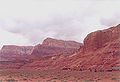
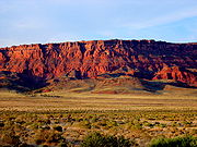
The Vermilion Cliffs are made up of deposited silt
Silt
Silt is granular material of a size somewhere between sand and clay whose mineral origin is quartz and feldspar. Silt may occur as a soil or as suspended sediment in a surface water body...
and desert dunes, cemented by infiltrated carbonate
Carbonate
In chemistry, a carbonate is a salt of carbonic acid, characterized by the presence of the carbonate ion, . The name may also mean an ester of carbonic acid, an organic compound containing the carbonate group C2....
s and intensely colored by red iron oxide
Iron oxide
Iron oxides are chemical compounds composed of iron and oxygen. All together, there are sixteen known iron oxides and oxyhydroxides.Iron oxides and oxide-hydroxides are widespread in nature, play an important role in many geological and biological processes, and are widely utilized by humans, e.g.,...
and other minerals, particularly bluish manganese
Manganese
Manganese is a chemical element, designated by the symbol Mn. It has the atomic number 25. It is found as a free element in nature , and in many minerals...
. In the spring, after a good winter rain, the valley between Highway 89 and the Vermilion Cliffs will be covered with a carpet of desert mallow and other spring flowers.
In the image below, Highway 89 is atop the yellow rocks capping the first step of the series, the Chocolate Cliffs and will turn east (to the right) upon entry to the valley below, ultimately crossing the Colorado river
Colorado River
The Colorado River , is a river in the Southwestern United States and northwestern Mexico, approximately long, draining a part of the arid regions on the western slope of the Rocky Mountains. The watershed of the Colorado River covers in parts of seven U.S. states and two Mexican states...
at Marble Canyon
Marble Canyon
Marble Canyon is the section of the Colorado River canyon in northern Arizona from Lee's Ferry to the confluence with the Little Colorado River, which marks the beginning of the Grand Canyon....
via the Navajo Bridge
Navajo Bridge
Navajo Bridge crosses the Colorado River's Marble Canyon near Lee's Ferry in the US state of Arizona. Apart from the Glen Canyon Bridge a few miles upstream at Page, Arizona, it is the only roadway crossing of the river and the Grand Canyon for nearly...
.