

Geology of Serbia
Encyclopedia
Serbia
Serbia , officially the Republic of Serbia , is a landlocked country located at the crossroads of Central and Southeast Europe, covering the southern part of the Carpathian basin and the central part of the Balkans...
is part of the Alpine
Alpine orogeny
The Alpine orogeny is an orogenic phase in the Late Mesozoic and Tertiary that formed the mountain ranges of the Alpide belt...
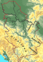
orogenic belt of Southeastern Europe. Its territory can be divided into five geotectonic units of differing genesis:
- Pannonian Plain, occupying the northern part of the country (VojvodinaVojvodinaVojvodina, officially called Autonomous Province of Vojvodina is an autonomous province of Serbia. Its capital and largest city is Novi Sad...
province) - Dinaric AlpsDinaric AlpsThe Dinaric Alps or Dinarides form a mountain chain in Southern Europe, spanning areas of Slovenia, Croatia, Bosnia and Herzegovina, Serbia, Kosovo, Albania and Montenegro....
occupy western part of Central Serbia, stretching in general northwest-southeast direction - Vardar Zone is a belt east of the Dinaric alps, continuing into central Republic of MacedoniaRepublic of MacedoniaMacedonia , officially the Republic of Macedonia , is a country located in the central Balkan peninsula in Southeast Europe. It is one of the successor states of the former Yugoslavia, from which it declared independence in 1991...
. It consists of three parts: SremSremŚrem is a town on the Warta river in central Poland. It has been situated in the Greater Poland Voivodeship since 1999; from 1975 to 1998 it was part of the Poznań Voivodeship...
, JadarJadarJadar may refer to:* Jadar , a river in western Serbia, tributary to the Drina* Jadar , a river in eastern Republika Srpska, Bosnia and Herzegovina, tributary to the Drinjača...
and KopaonikKopaonikKopaonik ; is one of the larger mountain ranges of Serbia. It is located in the central part of Serbia, while a small portion extendeds to North Kosovo. Its highest point, Pančić's Peak, is above sea level....
blocks, separated by ophiolitics fractures. - Serbian-Macedonian Massif is a belt stretching in north-south direction along the Great and South Morava valleys, into western Republic of Macedonia and northern Greece (north of Chalkidiki peninsula).
- Carpatho-Balkan arc covers Eastern Serbia, in the shape of an arc. Its northern part, Serbian CarpathiansSerbian CarpathiansSerbian Carpathians is a mountain range in eastern Central Serbia. It presents an extension of proper Carpathian Mountains across the Danube, connecting them with the Balkan Mountains in the southeast. They stretch in north-south direction in the eastern Serbia, west of the Great Morava valley and...
is an extension of CarpathianCarpathianCarpathian may refer to:*Carpathian Mountains of Central and Eastern Europe*Carpathian Convention on sustainable development in that region*Carpathian Shepherd Dog, a Romanian sheep dog*Subcarpathian Voivodeship, an administrative division of Poland...
range, and it joins the western parts of Balkan MountainsBalkan MountainsThe Balkan mountain range is a mountain range in the eastern part of the Balkan Peninsula. The Balkan range runs 560 km from the Vrashka Chuka Peak on the border between Bulgaria and eastern Serbia eastward through central Bulgaria to Cape Emine on the Black Sea...
, whose main massif is in BulgariaBulgariaBulgaria , officially the Republic of Bulgaria , is a parliamentary democracy within a unitary constitutional republic in Southeast Europe. The country borders Romania to the north, Serbia and Macedonia to the west, Greece and Turkey to the south, as well as the Black Sea to the east...
.
Seismic activity
Serbia is prone to moderate to strong seismic activity, especially in the central belts of Vardar Zone and Serbian Massif. Major earthquakes in the 20th century ranged between 5.0 from 6.0 (LazarevacLazarevac
Lazarevac is a town and municipality located in Serbia at 44.22° North, 20.15° East. Its name stems from name of medieval Prince Lazar Hrebeljanovic. In 2002 the town has total population of 23,551. Lazarevac is one of Belgrade's 17 municipalities....
1922) Richter scale. The last major earthquake at 5.4 occurred near Kraljevo
2010 Serbia earthquake
The 2010 Serbia earthquake occurred on 3 November 2010 just several kilometers from Kraljevo, in central Serbia. The earthquake had magnitude of 5.3 and was felt across the country. including the capital, Belgrade, as well as in several neighboring countries. Two people were killed and over 100...
on 3 November 2010.
List of major earthquakes in the 20th and 21st centuries:
- 1893. SvilajnacSvilajnacSvilajnac is a town and municipality located in central Serbia at 44.13° North, 21.12° East, south-east of Belgrade, on the banks of the river Resava, and bordering the river Morava. Its name stems from the word for silk in Serbian. It is the de facto administrative center of the Resava region...
– 5,7 Richter scale - 1921. VitinaVitinaVitina is a town and municipality in the Gnjilane district of south-eastern Kosovo.-Geography:Towns in the Vitina municipality include Pozhoran, Kabash, Binqa, Kllokot, Drobesh, Smirë, etc.-History:...
– 5,7 - 1922. LazarevacLazarevacLazarevac is a town and municipality located in Serbia at 44.22° North, 20.15° East. Its name stems from name of medieval Prince Lazar Hrebeljanovic. In 2002 the town has total population of 23,551. Lazarevac is one of Belgrade's 17 municipalities....
– 5,9 - 1927. RudnikRudnikRudnik is a mountain in central Serbia, near the town of Gornji Milanovac. Its highest peak Cvijićev vrh, named after geologist and biologist Jovan Cvijić, has an altitude of 1132 meters above sea level...
– 5,7 - 1980. KopaonikKopaonikKopaonik ; is one of the larger mountain ranges of Serbia. It is located in the central part of Serbia, while a small portion extendeds to North Kosovo. Its highest point, Pančić's Peak, is above sea level....
– 5,7 - 1983.1983 Kopaonik earthquake1983 Kopaonik earthquake was a 5.3 Richter earthquake in Serbia, at Kopaonik. The epicenter was Kopaonik mountains, it struck seven villages leaving 200 homeless, 100 miles south, 1,200 buildings and dwellings were damaged....
KopaonikKopaonikKopaonik ; is one of the larger mountain ranges of Serbia. It is located in the central part of Serbia, while a small portion extendeds to North Kosovo. Its highest point, Pančić's Peak, is above sea level....
– 5,3 - 1998. MionicaMionicaMionica is a town and municipality located in the Kolubara District of Serbia. In 2011, the population of the town is 1,571, while population of the municipality is 14,263....
– 5,7 - 2010. KraljevoKraljevoKraljevo is a city and municipality in central Serbia, built beside the river Ibar, 7 km west of its confluence with the Western Morava. It is located in the midst of an upland valley, between the mountains of Kotlenik in the north, and Stolovi in the south.In 2011 the city has population of...
– 5,4
See also
- Geography of SerbiaGeography of SerbiaSerbia is country located in the Balkans and in the Pannonian Plain . It shares borders with Bosnia-Herzegovina, Bulgaria, Croatia, Hungary, the Republic of Macedonia, Montenegro, and Romania. Serbia claims a border with Albania as well through its disputed territory of Kosovo...
- List of caves in Serbia
- List of mountains in Serbia