
List of mountains in Serbia
Encyclopedia
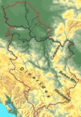
This is the full list of mountain
s in Serbia
(including Kosovo
). Most of Serbia is covered with low and medium-high mountains. Mountains in central, western and southwestern Serbia belong to the Dinarides range, while the Carpates, Balkan Mountains
and Rhodopes meet in the east.
 This is the list of mountains and their highest peaks. When a mountain has several major peaks, they are listed separately.
Cities located on Kosovo are indicated in grey. The associated mountains lay partially or entirely on the territory of Kosovo.
.
Mountain
Image:Himalaya_annotated.jpg|thumb|right|The Himalayan mountain range with Mount Everestrect 58 14 160 49 Chomo Lonzorect 200 28 335 52 Makalurect 378 24 566 45 Mount Everestrect 188 581 920 656 Tibetan Plateaurect 250 406 340 427 Rong River...
s in Serbia
Serbia
Serbia , officially the Republic of Serbia , is a landlocked country located at the crossroads of Central and Southeast Europe, covering the southern part of the Carpathian basin and the central part of the Balkans...
(including Kosovo
Kosovo
Kosovo is a region in southeastern Europe. Part of the Ottoman Empire for more than five centuries, later the Autonomous Province of Kosovo and Metohija within Serbia...
). Most of Serbia is covered with low and medium-high mountains. Mountains in central, western and southwestern Serbia belong to the Dinarides range, while the Carpates, Balkan Mountains
Balkan Mountains
The Balkan mountain range is a mountain range in the eastern part of the Balkan Peninsula. The Balkan range runs 560 km from the Vrashka Chuka Peak on the border between Bulgaria and eastern Serbia eastward through central Bulgaria to Cape Emine on the Black Sea...
and Rhodopes meet in the east.
Full list
Cities located on Kosovo are indicated in grey. The associated mountains lay partially or entirely on the territory of Kosovo.
| Mountain | Highest peak(s) | Altitude Altitude Altitude or height is defined based on the context in which it is used . As a general definition, altitude is a distance measurement, usually in the vertical or "up" direction, between a reference datum and a point or object. The reference datum also often varies according to the context... (m) |
Coordinates | Nearest town |
|---|---|---|---|---|
| Avala Avala Avala is a mountain in Serbia, overlooking Belgrade. It is situated in the south-eastern corner of the city and provides a great panoramic view to Belgrade, Vojvodina and Šumadija, as the surrounding area on all sides is mostly a lowlands... |
. | 506 | 44°41′08"N 20°31′14"E | Belgrade Belgrade Belgrade is the capital and largest city of Serbia. It is located at the confluence of the Sava and Danube rivers, where the Pannonian Plain meets the Balkans. According to official results of Census 2011, the city has a population of 1,639,121. It is one of the 15 largest cities in Europe... |
| Baba Baba (Serbia) Baba is a mountain in central Serbia, east of the city of Paraćin. It has an altitude of 657 metres above sea level.At the northern edge of the mountain, there is Orthodox monastery Lešje from 14th century.-External links:*... |
. | 657 | 43°50′13"N 21°33′06"E | Paraćin Paracin Paraćin is a town and municipality in Serbia, located in the valley of the Velika Morava river, north of Kruševac and southeast of Kragujevac. In 2011 the town has total population of 24,573 and it has a civil airport, also known as Davidovac Airport.... |
| Babička Gora Babička Gora Babička Gora is a mountain in southern Serbia, near the city of Leskovac. Its highest peak, Kriva buka has an altitude of 1059 metres above sea level.... |
Kriva Buka | 1059 | 43°07′35"N 22°03′43"E | Leskovac Leskovac Leskovac is a city and municipality in southern Serbia. It is the administrative center of the Jablanica District of Serbia... |
| Belava Belava Belava is a mountain in eastern Serbia, near the town of Bela Palanka. Its highest peak Kardašica has an altitude of 946 meters above sea level.... |
Kardašica | 946 | 43°11′38"N 22°28′37"E | Bela Palanka Bela Palanka Bela Palanka is a town and municipality located in the Pirot District of south-east Serbia. According to 2011 census, the population of the town is 8,112, while population of the municipality is 12,051. In ancient times, the town was known as Remesiana... |
| Beljanica Beljanica Babička Gora is a mountain in Homolje region in eastern Serbia, near the town of Žagubica. Its highest peak has an altitude of 1339 metres above sea level.... |
Beljanica | 1339 | 44°06′41"N 21°41′59"E | Žagubica Žagubica Žagubica is a village and municipality located in the Braničevo District of Serbia. In 2011, the population of the village is 2,584, while population of the municipality is 12,484.-Name:... |
| Besna Kobila Besna Kobila Besna Kobila is a mountain in southeastern Serbia. Its eponymous highest peak is 1923 m tall. It lies 35km to the east from the city of Vranje. There is a mountain chalet Besna Kobila from where it takes an hour to hour and a half to reach the summit on foot... |
Šuplja Padina | 1862 | 42°30′20"N 22°14′9"E | Vranje Vranje Vranje is a city and municipality located in southern Serbia. In 2011 the city has total population of 82,782, while the urban area has 54,456... |
| Besna Kobila | 1923 | 42°31′46"N 22°13′50"E | Vranje Vranje Vranje is a city and municipality located in southern Serbia. In 2011 the city has total population of 82,782, while the urban area has 54,456... |
|
| Bić Bić Bić is a mountain on the border of Serbia and Bosnia and Herzegovina, above the town of Priboj. Its highest peak, Golet, is 1386 metres tall. At the foothill, there is medieval fortified city of Jagat.... |
Golet | 1386 | 43°34′11"N 19°29′22"E | Priboj Priboj Priboj is a town and municipality located in the Zlatibor District of Serbia at 43.59° North, 19.54° East. In 2011, the town has a total population of 14,015, while population of the municipality is 27,127.- History :... |
| Blagaja Blagaja Blagaja is a mountain in central Serbia, near the town of Arilje. Its highest peak Ravni krš has an altitude of 844 meters above sea level.... |
Ravni krš | 844 | 43°46′23"N 20°00′54"E | Arilje Arilje Arilje is a town and municipality in western Serbia, in the Zlatibor District. In 2011 the town has a total population of 6,762, while the municipality had 18,729. The town's coordinates are 43.75°N and 20.10°E... |
| Bobija Bobija Bobija is a mountain in western Serbia, near the town of Ljubovija. Its highest peak, Tornička Bobija, has an altitude of 1272 metres above sea level.-External links:*... |
Tornička Bobija | 1272 | 44°11′46"N 19°33′16"E | Ljubovija Ljubovija Ljubovija is a town and municipality located in the Mačva District of Serbia. In 2011, the population of the town is 3,946 while the population of the municipality is 14,424.-Municipality:The municipality of Ljubovija includes the following settlements:... |
| Boranja Boranja Boranja is a mountain in western Serbia, above the Drina river, between towns of Krupanj and Mali Zvornik. Its highest peak, Crni vrh is 856 metres tall.-External links:*... |
Crni vrh | 856 | 44°22′34"N 19°15′32"E | Krupanj Krupanj Krupanj is a town and municipality located in the Mačva District of Serbia. The municipality has a total population of 17,398, while the town has a population of 4,455 .-Geography:... |
| Bukulja Bukulja Bukulja is a mountain near Aranđelovac in central Serbia. This mountain is an extinct volcano, which has been proved by presence of granite rocks, which contains specific mineral composition. In the mountain foothills, there is water catchment Garaši, which provides Aranđelovac and nearby... |
Bukulja | 696 | 44°17′55"N 20°31′45"E | Aranđelovac |
| Bukovik Bukovik (mountain) Bukovik is a mountain in central Serbia, near the town of Ražanj. Its highest peak Bukova glava has an altitude of 894 meters above sea level.... |
894 | 43°41′30"N 21°38′08"E | Ražanj Ražanj Ražanj is a village and municipality located in the Nišava District of Serbia.The municipality of Razanj is located in the south east of Central Serbia, 55 km north of Nis, the third largest city of Serbia. It is a small municipality consisting of 23 settlements having a total population of... |
|
| Cer Cer (mountain) Cer is a mountain in western Serbia, 30 kilometers from Šabac, 100 kilometers west of Belgrade. The highest peak is 689 m high.During World War I, the Battle of Cer was fought on Cer, in which Serbian forces defeated Austria-Hungary.... |
Cer | 687 | 44°36′11"N 19°29′39"E | Šabac Šabac Šabac is a city and municipality in western Serbia, along the Sava river, in the historic region of Mačva. It is the administrative center of the Mačva District. The city has a population of 52,822 , while population of the municipality is 115,347... |
| . | 593 | 44°37′17"N 19°25′46"E | Šabac Šabac Šabac is a city and municipality in western Serbia, along the Sava river, in the historic region of Mačva. It is the administrative center of the Mačva District. The city has a population of 52,822 , while population of the municipality is 115,347... |
|
| Crni Vrh (Jagodina) Crni Vrh (Jagodina) Crni Vrh is a mountain in central Serbia, near the city of Jagodina. Its highest peak Crni vrh has an altitude of 707 meters above sea level. It is a small ski resort, with a mountaineering hut at the top, and two tracks of around 750 meters each.... |
Crni vrh | 707 | 44°00′32"N 21°06′41"E | Jagodina Jagodina Jagodina is a city and municipality located in central Serbia, 136 km south of Belgrade, on the banks of Belica River. Its name stems from the word for strawberry in Serbian. It is the administrative centre of the Pomoravlje District of Serbia... |
| Crni Vrh (Bor) Crni Vrh (Bor) Crni vrh is a mountain in eastern Serbia, between towns of Bor and Žagubica. Its eponymous highest peak is 1043 m high. It is a minor winter resort, and it has several ski tracks, although the infrastructure is in bad shape... |
Crni vrh | 1043 | 44°07′50"N 21°57′51"E | Bor Bor, Serbia Bor is a town and municipality located in eastern Serbia, with one of the largest copper mines in Europe and it has been a mining centre since 1904, when a French company began operations there. It is the administrative center of the Bor District of Serbia... |
| Crnokosa Crnokosa Crnokosa is a mountain in western Serbia, near the town of Kosjerić. Its highest peak has an altitude of 809 meters above sea level. It runs around 9 km along the Skrapež river, steeply closing its southern valley, while its southern slopes are milder.... |
. | 809 | 43°58′03"N 19°54′59"E | Kosjerić Kosjeric Kosjerić is a town and municipality in Western Serbia. The municipality has 12,873 inhabitants, but the town itself has 3,970. The municipality's area is 359 square kilometers, with 26 villages mostly placed in the river valleys, though there are also some settlements in the mountains at altitudes... |
| Crnoljeva Crnoljeva Crnoljeva is a mountain in central Kosovo, dividing its two main geographical regions, the Kosovo Plain and Metohija. Crnoljeva is also a point where all three drainage basins of Serbia meet, making the mountain a major hydrographic knot... |
Garamele | 1160 | 42°24′43"N 20°58′02"E | Štimlje |
| Gradina | 1055 | 42°28′48"N 20°51′01"E | Mališevo Mališevo Mališevo is a town and municipality in the Prizren District of central Kosovo... |
|
| Čemernik Čemernik Čemernik is a mountain in southeastern Serbia, near the town of Surdulica. Its highest peak Vrlo osoje has an altitude of 1638 meters above sea level. It is one of mountains that surround the Vlasina plateau and the Vlasina Lake.... |
Vrlo osoje | 1638 | 42°44′06"N 22°16′38"E | Surdulica Surdulica Surdulica is a town and municipality situated in the southeast of Serbia . In 2011, the population of the town is 10,915, while population of the municipality is 20,265.-Geography:... |
| Čemernica Čemernica (Serbia) Čemernica is a mountain in western Serbia, near the town of Ivanjica. Its highest peak Bela stena has an altitude of 1482 meters above sea level.... |
Bela stena | 1482 | 43°31′16"N 19°59′10"E | Ivanjica Ivanjica Ivanjica is a town and municipality located in the Moravica District of Serbia. The population of the town is 11,810, while population of the municipality is 32,047.... |
| Čemerno Čemerno Čemerno is a mountain in western Serbia, near the town of Ivanjica. Its highest peak Smrdljuč has an altitude of 1579 meters above sea level.-External links:*... |
Smrdljuč | 1579 | 43°34′57"N 20°25′33"E | Ivanjica Ivanjica Ivanjica is a town and municipality located in the Moravica District of Serbia. The population of the town is 11,810, while population of the municipality is 32,047.... |
| Deli Jovan Deli Jovan Deli Jovan is a mountain in eastern Serbia, near the town of Negotin. Its highest peak Crni vrh has an altitude of 1136 meters above sea level. On the top of the mountain, there is a TV tower.... |
Crni vrh | 1136 | 44°13′15"N 22°13′02"E | Negotin Negotin Negotin is a town and municipality in the Bor District of north-eastern Central Serbia. It is situated near the borders between Serbia, Romania and Bulgaria. It is the judicial center of the Bor District. The population of the town is 16,716 while municipality has 36,879.-Name:The etymology of the... |
| Devica Devica Devica is a mountain in eastern Serbia, near the town of Sokobanja. Its highest peak, Čapljinac has an altitude of 1187 metres above sea level... |
Čapljinac | 1187 | 43°35′38"N 21°56′39"E | Sokobanja Sokobanja Sokobanja is a well-known spa town and municipality situated in eastern Serbia.-Population:In 2011 the population of the Sokobanja town is 7,972, while population of the whole municipality is 15,981... |
| Drmanovina Drmanovina Drmanovina is a mountain in western Serbia, near the town of Kosjerić. Its highest peak Grad has an altitude of 1022 meters above sea level.... |
Grad | 1022 | 43°58′52"N 19°49′53"E | Kosjerić Kosjeric Kosjerić is a town and municipality in Western Serbia. The municipality has 12,873 inhabitants, but the town itself has 3,970. The municipality's area is 359 square kilometers, with 26 villages mostly placed in the river valleys, though there are also some settlements in the mountains at altitudes... |
| Dukat (mountain) Dukat (mountain) Dukat is a mountain in southeastern Serbia, near the town of Bosilegrad. Its highest peak Crnook has an altitude of 1881 meters above sea level.... |
Crnook | 1881 | 42°25′31"N 22°23′26"E | Bosilegrad Bosilegrad Bosilegrad is a town and municipality in Pčinja District of Serbia. The municipality comprises an area of 571 km². According to 2011 census, it has total population of 7,979 inhabitants, while the town has 2,530.-1991 census:... |
| Fruška Gora Fruška Gora Fruška Gora is a mountain in north Syrmia. Most part of the territory is located within Vojvodina, Serbia, but a smaller part on its western side overlaps the territory of Croatia... |
Crveni Čot | 538 | 45°09′07"N 19°42′48"E | Beočin Beocin Beočin is a town and municipality in the Vojvodina province, Serbia. The population of the town is 8,037, whilst Beočin's municipality population is 16,029... |
| Iriški Venac | 516 | 45°09′32"N 19°52′04"E | Irig | |
| Gajeva planina Gajeva planina Gajeva planina is a mountain on the border of Serbia and Bosnia and Herzegovina, between towns of Priboj and Rudo. Its highest peak Timor has an altitude of 1280 meters above sea level.... |
Timor | 1280 | 43°35′25"N 19°19′56"E | Priboj Priboj Priboj is a town and municipality located in the Zlatibor District of Serbia at 43.59° North, 19.54° East. In 2011, the town has a total population of 14,015, while population of the municipality is 27,127.- History :... |
| Giljeva Giljeva Giljeva is a mountain in southwestern Serbia, near the town of Sjenica in Sandžak region. Its highest peak Jelenak has an altitude of 1617 meters above sea level.... |
Jelenak | 1617 | 43°10′45"N 19°54′24"E | Sjenica Sjenica Sjenica , is a town and municipality in the Zlatibor District of Serbia. The population of the town, according to 2011 census, is 13,056 inhabitants, while the municipality has 25,448.-History:... |
| Gledić mountains Gledić mountains Gledić mountains is a mountain in central Serbia, between cities of Kragujevac and Trstenik. Its highest peak Samar has an altitude of 922 meters above sea level. The mountains are named after the village Gledić in its western part.... |
Crni vrh | 895 | 43°51′42"N 20°54′21"E | Kragujevac Kragujevac Kragujevac is the fourth largest city in Serbia, the main city of the Šumadija region and the administrative centre of Šumadija District. It is situated on the banks of the Lepenica River... |
| Samar | 922 | 43°45′03"N 20°57′03"E | Trstenik Trstenik Trstenik is a town and municipality located in the Rasina District of Serbia. According to 2011 census, the population of the town is 15,329, while population of the municipality was 42,989. It lies on the West Morava. The town is known for its industry of hydraulics and pneumatics company, Prva... |
|
| Gloška planina Gloška planina Gloška planina is a mountain in southeastern Serbia, near the town of Bosilegrad. Its highest peak Mečit has an altitude of 1756 meters above sea level.-External links:*... |
Mečit | 1756 | 42°31′41"N 22°22′32"E | Bosilegrad Bosilegrad Bosilegrad is a town and municipality in Pčinja District of Serbia. The municipality comprises an area of 571 km². According to 2011 census, it has total population of 7,979 inhabitants, while the town has 2,530.-1991 census:... |
| Goč Goč Goč is a mountain in central Serbia, south of the spa town of Vrnjačka Banja. Its highest peak Ljukten has an altitude of 1216 meters above sea level.... |
Ljukten | 1216 | 43°32′11"N 20°50′44"E | Vrnjačka Banja Vrnjacka Banja Vrnjačka Banja is a town, municipality, and a resort, mineral spa located in Raška District of Serbia. It contains the world's only hot spring with a temperature measuring exactly that of the human body .... |
| Golija Golija Golija is a mountain in southwestern Serbia, between towns of Ivanjica and Novi Pazar. It belongs to the Dinaric mountain range. The mountain is heavily forested, with significant biodiversity and it hosts the Golija-Studenica Biosphere Reserve, the first UNESCO-MAB registered biosphere reserve in... |
Crni vrh | 1795 | 43°18′44"N 20°23′27"E | Raška Raška (town) Raška is a town and municipality in south-central Serbia. Municipality has a population of 24,680 people, while the town has a population of 6,574 people . It covers an area of 670 square kilometers. The town is situated on rivers Raška and Ibar.- External links :*... |
| Jankov kamen | 1833 | 43°20′16"N 20°16′36"E | Ivanjica Ivanjica Ivanjica is a town and municipality located in the Moravica District of Serbia. The population of the town is 11,810, while population of the municipality is 32,047.... |
|
| Golubac Golubac (mountain) Golubac is a mountain in central Serbia, near the town of Guča. Its highest peak Stanojev vrh has an altitude of 733 meters above sea level.... |
Stanojev vrh | 733 | 43°44′11"N 20°11′53"E | Guča Guca Guča is a small town in Serbia. It is situated in the Lučani municipality, Moravica District. The population of the town is 2,022 people. Guča is a three-hour bus journey from Belgrade... |
| Goljak Goljak Goljak are mountains in the eastern part of Kosovo, bordering the Lab region to the west and Central Serbia to the east. The cities of Pristina and Gnjilane in Kosovo, and Sijarinska Banja in Central Serbia are located by the mountains... |
Novakova | 1101 | 42°43′43"N 21°32′31"E | Sijarinska Banja Sijarinska Banja Sijarinska Banja is a spa town in south Serbia. It is situated in the Medveđa municipality, in the Jablanica District. The population of the town is 568 people... |
| Velja glava | 1181 | 42°41′30"N 21°41′21"E | Sijarinska Banja Sijarinska Banja Sijarinska Banja is a spa town in south Serbia. It is situated in the Medveđa municipality, in the Jablanica District. The population of the town is 568 people... |
|
| Gramada Gramada (mountain) Gramada or Crkvena planina is a mountain in southeastern Serbia, north of the Vlasina heights and Vlasina Lake. Its highest peak Vrtop has an altitude of 1721 meters above sea level.... |
Vrtop | 1721 | 42°47′33"N 22°22′20"E | Surdulica Surdulica Surdulica is a town and municipality situated in the southeast of Serbia . In 2011, the population of the town is 10,915, while population of the municipality is 20,265.-Geography:... |
| Greben Greben (mountain) Greben is a mountain in southeastern Serbia, near the town of Dimitrovgrad and the Bulgarian border, with a small section of the southwestern ridge in Bulgaria. Its highest peak Beženište stands at an altitude of 1338 meters above sea level.The mountain is named after a large karst ridge that... |
Beženište | 1338 | 42°56′54"N 22°38′29"E | Dimitrovgrad Dimitrovgrad Dimitrovgrad is the name of three towns in Europe:* Dimitrovgrad, Bulgaria* Dimitrovgrad, Russia* Dimitrovgrad, SerbiaAll three were named after Georgi Dimitrov.... |
| Grot Grot (mountain) Grot is a mountain in southern Serbia, near the city of Vranje. Its highest peak has an altitude of 1327 meters above sea level.Like the nearby Oblik, Grot is an ancient inactive volcano.... |
Grot | 1327 | 42°37′30"N 21°54′30"E | Vranje Vranje Vranje is a city and municipality located in southern Serbia. In 2011 the city has total population of 82,782, while the urban area has 54,456... |
| Gučevo Gučevo Gučevo is a mountain in western Serbia, near the town of Loznica, overlooking the Drina river and Banja Koviljača. Its highest peak Crni vrh has an altitude of 779 meters above sea level.... |
Crni Vrh | 779 | 44°28′50"N 19°11′04"E | Loznica |
| Hajla Hajla Hajla is a mountain located between Kosovo and Montenegro. It has several peaks that reach over , the highest having which is also called Hajla. In its northern slopes, the river Ibar originates, and to its southern slopes is the origin of the Pećka Bistrica river. Hajla is also the highest... |
Hajla | 2403 | 42°45′25"N 20°08′21"E | Peć Pec Peć or Pejë is a city and municipality in north-western Kosovo and Metohija - Serbia, and the administrative centre of the homonymous district. Governor of city is Ali Berisha.... |
| Homolje mountains Homolje mountains Homolje mountains is a mountain range in eastern Serbia. It lies in the region known as Homolje between towns of Žagubica on south and Kučevo on north. Its highest peaks are Štubej and Vranj . On the mountain, there is Orthodox monastery of Vitovnica... |
Veliki Vukan | 825 | 44°17′57"N 21°32′14"E | Petrovac na Mlavi |
| Vranj | 884 | 44°19′57"N 21°36′53"E | Petrovac na Mlavi | |
| Štubej | 940 | 44°21′31"N 21°37′46"E | Petrovac na Mlavi | |
| Hum Hum (Pešter) Hum is a mountain in southwest Serbia, near the town of Tutin. Its highest peak, Gradina, has an altitude of 1502 metres above sea level. With nearby Jarut, it forms the southern edge of the Pešter plateau.... |
Gradina | 1502 | 43°00′43"N 20°13′00"E | Tutin Tutin Tutin is a town and municipality in Raška/Sandžak region of Serbia. According to a 2011 census, the municipality of Tutin has a population of 30,770 people. It is the first municipality in Serbia that has renewable wind power.-History:... |
| Jablanik Jablanik Jablanik is a mountain in western Serbia, near the town of Valjevo. Its highest peak Jablanik has an altitude of 1274 meters above sea level.... |
Jablanik | 1274 | 44°10′35"N 19°40′00"E | Valjevo Valjevo Valjevo is a city and municipality located in western Serbia. It is the center of the Kolubara District, which includes five other smaller municipalities with a total population of almost 180,000 people... |
| Jadovnik Jadovnik Jadovnik is a mountain in southwestern Serbia, on the western edge of Pešter plateau, near the town of Sjenica. Its highest peak Katunić has an altitude of 1734 meters above sea level.... |
Katunić | 1734 | 43°16′36"N 19°50′00"E | Sjenica Sjenica Sjenica , is a town and municipality in the Zlatibor District of Serbia. The population of the town, according to 2011 census, is 13,056 inhabitants, while the municipality has 25,448.-History:... |
| Jagodnja Jagodnja Jagodnja is a mountain in western Serbia, near the town of Krupanj. Its highest peak Košutnja Stopa has an altitude of 939 meters above sea level.... |
Košutnja Stopa | 939 | 44°20′39"N 19°17′37"E | Krupanj Krupanj Krupanj is a town and municipality located in the Mačva District of Serbia. The municipality has a total population of 17,398, while the town has a population of 4,455 .-Geography:... |
| Jarut Jarut Jarut is a mountain in southwestern Serbia, surrounding the Pešter plateau, near the town of Tutin. Its highest peak Markov vrh has an altitude of 1428 meters above sea level.... |
Markov vrh | 1428 | 43°03′54"N 20°14′42"E | Tutin Tutin Tutin is a town and municipality in Raška/Sandžak region of Serbia. According to a 2011 census, the municipality of Tutin has a population of 30,770 people. It is the first municipality in Serbia that has renewable wind power.-History:... |
| Javor Javor (Serbia) Javor is a mountain in central Serbia, between towns of Sjenica and Ivanjica. Its highest peak Vasilin vrh has an altitude of 1519 meters above sea level.... |
Vasilin vrh | 1519 | 43°26′29"N 20°03′16"E | Sjenica Sjenica Sjenica , is a town and municipality in the Zlatibor District of Serbia. The population of the town, according to 2011 census, is 13,056 inhabitants, while the municipality has 25,448.-History:... |
| Javorište Javorište Javorište is a mountain in eastern Serbia, near the town of Resavica. Its highest peak Oštri kamen has an altitude of 1213 meters above sea level. It is part of wider Kučaj mountain system, which belongs to Serbian Carpathians range.... |
Oštri kamen | 1213 | 44°01′57"N 21°47′29"E | Resavica |
| Javorje Javorje (Serbia) Javorje is a mountain in western Serbia, near the town of Priboj. Its highest peak Ober has an altitude of 1486 meters above sea level.... |
Ober | 1486 | 43°32′32"N 19°17′43"E | Priboj Priboj Priboj is a town and municipality located in the Zlatibor District of Serbia at 43.59° North, 19.54° East. In 2011, the town has a total population of 14,015, while population of the municipality is 27,127.- History :... |
| Jelica Jelica Jelica is a mountain in central Serbia, near the town of Čačak. Its highest peak Crna Stena has an altitude of 929 meters above sea level.... |
Crna Stena | 929 | 43°47′34"N 20°21′36"E | Čačak Cacak Čačak is a city in central Serbia. It is the administrative center of the Moravica District of Serbia. Čačak is also the main industrial, cultural and sport center of the district... |
| Jelova Gora Jelova Gora Jelova Gora is a mountain in western Serbia, between cities of Užice and Bajina Bašta. Its highest peak Đakov kamen has an altitude of 1011 meters above sea level.... |
Đakov kamen | 1011 | 43°56′59"N 19°46′27"E | Užice Užice Užice is a city and municipality in western Serbia, located at the banks of the Đetinja river. It is the administrative center of the Zlatibor District... |
| Ješevac Ješevac Ješevac is a mountain in central Serbia, near the town of Gornji Milanovac. Its highest peak Crni vrh has an altitude of 902 meters above sea level.... |
Crni vrh | 902 | 44°04′55"N 20°32′45"E | Gornji Milanovac Gornji Milanovac Gornji Milanovac is a town and municipality located in Serbia at 44.012691° North, 20.273572° East. Its name means "Upper Milanovac" while Milanovac stems from name "Milan" in the Serbian language. The population of town is 24,048.The city was founded in 1853... |
| Jezerska planina | Ostrvica | 2092 | 42°14′29"N 20°54′51"E | Prizren Prizren Prizren is a historical city located in southern Kosovo. It is the administrative center of the eponymous municipality and district.The city has a population of around 131,247 , mostly Albanians... |
| Karadino | 1656 | 42°18′01"N 21°02′3"E | Štrpce Štrpce Štrpce is a town and municipality in the District of Uroševac, Kosovo and Metohija.According to the 1991 census, the municipality of Štrpce had a population of around 12,800 people... |
|
| Bukova glava | 1677 | 42°19′35"N 20°58′4"E | Suva Reka | |
| Studenica | 1723 | 42°18′37"N 20°59′1"E | Suva Reka | |
| Ježevac Ježevac (mountain) Ježevac is a mountain in eastern Serbia, near the town of Petrovac na Mlavi. Its highest peak has an altitude of 675 meters above sea level. Ježevac sharply rises over the southern edge of Mlava river gorge, entering the Homolje region. On the mountain, there is Gornjak Monastery carved into... |
675 | 44°15′53"N 21°31′02"E | Petrovac na Mlavi | |
| Juhor Juhor Juhor is a mountain in central Serbia, near the city of Paraćin. Its highest peak Veliki Vetren has an altitude of 774 meters above sea level... |
Veliki Vetren | 774 | 43°48′44"N 21°15′51"E | Paraćin Paracin Paraćin is a town and municipality in Serbia, located in the valley of the Velika Morava river, north of Kruševac and southeast of Kragujevac. In 2011 the town has total population of 24,573 and it has a civil airport, also known as Davidovac Airport.... |
| Kablar Kablar Kablar is a mountain in central Serbia. It has an altitude of 889 metres above sea level. It lies near the city of Čačak. With nearby Ovčar, it forms the Ovčar-Kablar Gorge of the West Morava river.... |
. | 889 | 43°54′48"N 20°11′05"E | Čačak Cacak Čačak is a city in central Serbia. It is the administrative center of the Moravica District of Serbia. Čačak is also the main industrial, cultural and sport center of the district... |
| Kopaonik Kopaonik Kopaonik ; is one of the larger mountain ranges of Serbia. It is located in the central part of Serbia, while a small portion extendeds to North Kosovo. Its highest point, Pančić's Peak, is above sea level.... |
Oštro Koplje Oštro Koplje Oštro Koplje , which means "Flag") is a highest mountain peak in southern Kopaonik mountains in Kosovo. At 1789m high it is the second highest mountain in the Kosovan part of Kopaonik. Because of its height the mountain and its surroundings are treeless... |
1789 | 43°01′10"N 21°00′59"E | Podujevo Podujevo Podujevo or Podujeva is a town and municipality located in the district of Pristina of north-eastern Kosovo.Podujevo is situated in a strategic position due to a regional motorway and railroad passing through it which links surrounding regions. Pristina, the capital of Kosovo, is located some to... |
| Pančićev Vrh | 2016 | 43°16′05"N 20°49′35"E | Raška Raška (town) Raška is a town and municipality in south-central Serbia. Municipality has a population of 24,680 people, while the town has a population of 6,574 people . It covers an area of 670 square kilometers. The town is situated on rivers Raška and Ibar.- External links :*... |
|
| Šatorica Šatorica Šatorica which means "tent") is a mountain peak in the southern part of the Kopaonik range in the north of Kosovo. At 1,750m high it is the third highest peak in the Kosovan part of the range and the Lab River originates close to this mountain peak.... |
1750 | 43°06′41"N 20°58′28"E | Leposavić Leposavic Leposavić is a town and [Municipalities of Kosovo|municipality]] in the district of Kosovska Mitrovica of northern Kosovo. It is a part of North Kosovo, a region with at least 98%ethnic Serb majority that functions largely autonomously from the remainder of the ethnic-Albanian-majority Kosovo... |
|
| Koritnik Koritnik Koritnik is a mountain located in north-eastern Albania and south of Kosovo. It is high. It is totally surrounded by branches of the White Drin. In Kosovo the towns of Šar and Zur are next to the mountain. The Koritnik mountain because of its high pastures contains a population of 60 chamois.-... |
Koritnik | 2393 | 42°04′50"N 20°33′24"E | Prizren Prizren Prizren is a historical city located in southern Kosovo. It is the administrative center of the eponymous municipality and district.The city has a population of around 131,247 , mostly Albanians... |
| Kosmaj Kosmaj Kosmaj is a mountain south of Belgrade, the capital of Serbia. With an elevation of 626 meters, it is the highest point of the entire Belgrade City area and is nicknamed one of two "Belgrade mountains" .- Location :The Kosmaj, is located 40 kilometers south-east of Belgrade... |
Kosmaj | 626 | 44°27′56"N 20°33′56"E | Mladenovac Mladenovac Mladenovac is a town and municipality located in Serbia at 44.43° North, 20.70° East. Mladenovac is one of Belgrade's 17 municipalities. In 2003 the town had total population of 22,200.-Name:... |
| Kotlenik Kotlenik Kotlenik is a mountain in central Serbia, near the town of Kraljevo. Its highest peak Veliki vrh has an altitude of 749 meters above sea level.-External links:*, Staze i Bogaze.... |
Veliki Vrh | 749 | 43°50′35"N 20°40′43"E | Kraljevo Kraljevo Kraljevo is a city and municipality in central Serbia, built beside the river Ibar, 7 km west of its confluence with the Western Morava. It is located in the midst of an upland valley, between the mountains of Kotlenik in the north, and Stolovi in the south.In 2011 the city has population of... |
| Kozjak | Virovi | 1283 | 42°18′37"N 21°55′42"E | Bujanovac Bujanovac Bujanovac is a town and municipality in Pčinja District of southern Serbia, located at the South Morava basin.It is known for its source of mineral water, so it is also known as Bujanovačka Banja .... |
| Koznica Koznica Koznica is a mountain in western Kosovo, near the town of Novo Brdo. Its highest peak Grbeš has an altitude of above sea level. It is part of the Goljak mountains. The city of Pristina is located to the west of the mountain.... |
Grbeš | 1230 | 42°39′32"N 21°22′30"E | Novo Brdo Novo Brdo Novo Brdo is a town and municipality in the Pristina district of eastern Kosovo. The population of the municipality is estimated at 6,720 people .-History:... |
| Krstac Krstac Krstač is an ancient variety of grape that is indigenous to Serbia and Montenegro. A high quality dry white wine is made of it. The wine may be rich, of harmonious bouquet and of light yellow color with 12.5% alcohol.- Synonyms :... |
Đava | 699 | 43°47′39"N 20°11′38"E | Guča Guca Guča is a small town in Serbia. It is situated in the Lučani municipality, Moravica District. The population of the town is 2,022 people. Guča is a three-hour bus journey from Belgrade... |
| Kruševica Kruševica (mountain) Kruševica is a mountain in southern Serbia, near the town of Vlasotince. Its highest peak Vita kruška has an altitude of 913 meters above sea level.... |
Vita kruška | 913 | 43°02′22"N 22°10′38"E | Vlasotince Vlasotince Vlasotince is town and municipality in south-east Serbia. The municipality has 29,669 inhabitants, while the town itself has a population of 15,830 .-History:... |
| Kučajske planine Kučajske planine Kučaj mountains is a mountain range in eastern Serbia. Its highest peak, Velika Tresta has an altitude of 1284 metres above sea level. They belong to Serbian extension of Carpathians... |
Velika Tresta | 1284 | 44°05′10"N 21°49′25"E | Zlot Zlot (Bor) Zlot is a town in the municipality of Bor, Serbia. According to the 2002 census, the town has a population of 3757 people.-References:... |
| Koprivno brdo | 1063 | 43°56′26"N 21°43′58"E | Senjski Rudnik Senjski Rudnik Senjski Rudnik is a village in eastern Serbia, in the municipality of Despotovac. According to the 2002 census, it had a population of 595. It is the site of the oldest preserved coal mine in Serbia, established in 1853. The mine marks the beginnings of the industrial revolution in Serbia... |
|
| Pozerak | 1049 | 44°02′11"N 21°39′46"E | Resavica | |
| Kukavica Kukavica Kukavica is a mountain in central Serbia, near the town of Vladičin Han. Its highest peak Vlajna has an altitude of 1442 meters above sea level.... |
Vlajna | 1442 | 42°47′29"N 21°56′47"E | Vladičin Han Vladicin Han Vladičin Han is a town and municipality located in the Pčinja District of Serbia. According to 2011 census, the population of the town is 8,053, while population of the municipality is 20,938... |
| Kukutnica Kukutnica Kukutnica is a mountain in western Serbia, near the town of Ivanjica. Its highest peak has an altitude of 1382 meters above sea level.... |
. | 1382 | 43°35′58"N 20°01′59"E | Ivanjica Ivanjica Ivanjica is a town and municipality located in the Moravica District of Serbia. The population of the town is 11,810, while population of the municipality is 32,047.... |
| Lepa Gora Lepa Gora Lepa Gora is a mountain in southern Serbia, near the town of Kuršumlija. Its highest peak Crna čuka has an altitude of 1196 meters above sea level.... |
Crna čuka | 1196 | 43°14′48"N 21°07′20"E | Kuršumlija Kuršumlija Kuršumlija is a town and municipality located in the south of Serbia, nearby the rivers Toplica, Kosanica and Banjska, on the southeast of mountain Kopaonik, and northwest of Radan Mountain... |
| Liškovac Liškovac Liškovac is a mountain in eastern Serbia, between towns of Majdanpek and Donji Milanovac. Its highest peak Veliki Liškovac has an altitude of 803 meters above sea level. Along with Miroč, Liškovac is part of the Iron Gate of the Danube river. It is located in the Đerdap national park.... |
Veliki Liškovac | 803 | 44°27′09"N 22°01′17"E | Majdanpek Majdanpek Majdanpek is a town and municipality in Bor District of Serbia. According to 2011 census, the municipality of Majdanpek has a population of 18,179 people, while the town of Majdanpek has a population of 7,367.... |
| Mali Jastrebac Mali Jastrebac Jastrebac is a mountain in central Serbia, between cities of Niš, Kruševac and Prokuplje. It consists of two massifs, Great and Small Jastrebac. Its highest peak Velika Đulica has an altitude of 1492 metres above sea level... |
Kupinjak | 948 | 43°23′38"N 21°37′42"E | Niš Niš Niš is the largest city of southern Serbia and third-largest city in Serbia . According to the data from 2011, the city of Niš has a population of 177,972 inhabitants, while the city municipality has a population of 257,867. The city covers an area of about 597 km2, including the urban area,... |
| Mali Krš Mali Krš Mali Krš is a mountain in eastern Serbia. Its highest peak, Garvan, has 929 metres above sea level. While not particularly rugged, Mali Krš is remote, hidden between nearby mountains of Liškovac, Veliki Krš and Homolje mountains. Like nearby Veliki Krš and Stol, Mali Krš is dominated by karst... |
Garvan | 929 | 44°17′08"N 22°00′58"E | Majdanpek Majdanpek Majdanpek is a town and municipality in Bor District of Serbia. According to 2011 census, the municipality of Majdanpek has a population of 18,179 people, while the town of Majdanpek has a population of 7,367.... |
| Malić Malíč Malíč is a village and municipality in Litoměřice District in the Ústí nad Labem Region of the Czech Republic.The municipality covers an area of , and has a population of 151 .... |
. | 1100 | 43°38′56"N 20°06′11"E | Ivanjica Ivanjica Ivanjica is a town and municipality located in the Moravica District of Serbia. The population of the town is 11,810, while population of the municipality is 32,047.... |
| Malinik Malinik Malinik is a mountain in eastern Serbia. Its highest peak, Veliki Malinik has an altitude of 1158 metres above sea level... |
Veliki Malinik | 1158 | 44°04′59"N 21°49′26"E | Zlot Zlot (Bor) Zlot is a town in the municipality of Bor, Serbia. According to the 2002 census, the town has a population of 3757 people.-References:... |
| Mali Malinik | 1019 | 43°59′09"N 21°54′19"E | Zlot Zlot (Bor) Zlot is a town in the municipality of Bor, Serbia. According to the 2002 census, the town has a population of 3757 people.-References:... |
|
| Maljen | Crni vrh | 1096 | 44°05′46"N 19°59′51"E | Valjevo Valjevo Valjevo is a city and municipality located in western Serbia. It is the center of the Kolubara District, which includes five other smaller municipalities with a total population of almost 180,000 people... |
| Kraljev Sto | 1103 | 44°07′08"N 20°01′22"E | Valjevo Valjevo Valjevo is a city and municipality located in western Serbia. It is the center of the Kolubara District, which includes five other smaller municipalities with a total population of almost 180,000 people... |
|
| Medvednik Medvednik Medvednik is a mountain in western Serbia, near the town of Valjevo. Its highest peak has an altitude of 1247 meters above sea level.... |
. | 1247 | 44°12′37"N 19°38′12"E | Valjevo Valjevo Valjevo is a city and municipality located in western Serbia. It is the center of the Kolubara District, which includes five other smaller municipalities with a total population of almost 180,000 people... |
| Milevska planina Milevska Planina Milevska planina is a mountain in southeastern Serbia and western Bulgaria, near the town of Bosilegrad. Its highest peak Milevets or Krvavi kamik has an altitude of 1738 meters above sea level. It is located at the border of two countries.... |
Krvavi kamik | 1738 | 42°33′54"N 22°26′22"E | Bosilegrad Bosilegrad Bosilegrad is a town and municipality in Pčinja District of Serbia. The municipality comprises an area of 571 km². According to 2011 census, it has total population of 7,979 inhabitants, while the town has 2,530.-1991 census:... |
| Miroč Miroč Miroč is a mountain in eastern Serbia, between the towns of Donji Milanovac and Tekija. Its highest peak Štrbac has an altitude of above sea level. Along with Liškovac, it is part of the Iron Gate gorge of the Danube river... |
Štrbac | 768 | 44°35′31"N 22°16′45"E | Donji Milanovac Donji Milanovac Donji Milanovac is a town in eastern Serbia. It is situated in the Majdanpek municipality, in the Bor District. It is located on right bank of Lake Đerdap on Danube... |
| . | 560 | 44°40′38"N 22°25′40"E | Tekija Tekija (Kladovo) Tekija is a village in the municipality of Kladovo in eastern Serbia. According to the 2002 census, the village has a population of 967 people.... |
|
| Mokra Gora | Novi Vrh | 1806 | 42°50′00"N 20°26′50"E | Peć Pec Peć or Pejë is a city and municipality in north-western Kosovo and Metohija - Serbia, and the administrative centre of the homonymous district. Governor of city is Ali Berisha.... |
| Pogled | 2154 | 42°49′54"N 20°22′03"E | Peć Pec Peć or Pejë is a city and municipality in north-western Kosovo and Metohija - Serbia, and the administrative centre of the homonymous district. Governor of city is Ali Berisha.... |
|
| Ruica | 1814 | 42°51′58"N 20°33′09"E | Peć Pec Peć or Pejë is a city and municipality in north-western Kosovo and Metohija - Serbia, and the administrative centre of the homonymous district. Governor of city is Ali Berisha.... |
|
| Mučanj Mučanj Mučanj is a mountain in western Serbia, near the town of Ivanjica. Its highest peak Klekov Vrh has an altitude of 1532 meters above sea level.... |
Klekov Vrh (Jerinin grad) | 1532 | 43°32′42"N 20°02′04"E | Ivanjica Ivanjica Ivanjica is a town and municipality located in the Moravica District of Serbia. The population of the town is 11,810, while population of the municipality is 32,047.... |
| Murtenica Murtenica Murtenica is a mountain in western Serbia, near the town of Nova Varoš. Its highest peak Brijač has an altitude of 1480 meters above sea level.... |
Brijač | 1480 | 43°35′23"N 19°47′32"E | Nova Varoš Nova Varoš Nova Varoš is a town and municipality in Zlatibor District of Serbia. According to the 1991 census, the municipality of Nova Varoš had a population of 21,812, while according to the 2011 census, the number of inhabitants in the municipality was 16,758... |
| Nerodimka Nerodimka Mountain The Nerodimka is a mountain located in the south of Kosovo. It is named either after the Serbian legend of the woman who can't deliver a baby, . The mountain has two high peaks, Bukova Glava and Kurkulica .-Geography:... |
Kula | 1544 | 42°18′37"N 21°03′5"E | Uroševac Uroševac Ferizaj or Uroševac is a city and municipality in southern Kosovo, located some south of the capital Pristina.Uroševac is the third most populous city in Kosovo, after Pristina and Prizren.It is the administrative centre of the homonymous district... |
| Ninaja | Homer | 1462 | 43°10′08"N 20°13′19"E | Novi Pazar Novi Pazar Novi Pazar is a city and municipality located in southwest Serbia, in the Raška District. According to the official census in 2011, number of inhabitants of municipality is 92,776, while the city itself has a population of 60,638... |
| Oblik Oblik (mountain) Oblik is a mountain in southern Serbia, near the city of Vranje. Its highest peak Oblik has an altitude of 1310 meters above sea level. Oblik is part of a larger massif including mountains of Kukavica, Seličevica and Grot.... |
Oblik | 1310 | 42°38′35"N 21°55′07"E | Vranje Vranje Vranje is a city and municipality located in southern Serbia. In 2011 the city has total population of 82,782, while the urban area has 54,456... |
| Ovčar Ovčar Ovčar is a mountain in western Serbia, near the city of Čačak. Its highest peak has an altitude of 985 meters above sea level. Along with Kablar, Ovčar forms the attractive Ovčar-Kablar Gorge of the West Morava river.... |
. | 985 | 43°53′48"N 20°12′50"E | Čačak Cacak Čačak is a city in central Serbia. It is the administrative center of the Moravica District of Serbia. Čačak is also the main industrial, cultural and sport center of the district... |
| Ostrozub Ostrozub Ostrozub is a mountain in southern Serbia, near the town of Crna Trava. It forms a continuous range with Čemernik mountain.The eponymous village... |
. | 1546 | 42°52′56"N 22°14′51"E | Crna Trava Crna Trava Crna Trava is a village and municipality located in the Jablanica District of Serbia. According to 2011 census, the population of the village is 452 inhabitants, while population of the municipality is 1,661. This is the poorest municipality in the country.-Name:The name of the village in Serbian... |
| Ozren (Pešter) Ozren (Pešter) Ozren is a mountain in southwestern Serbia, near the town of Sjenica. Its highest peak Orlovača has an altitude of 1693 meters above sea level. It is one of the mountains which surround the Pešter plateau. Spring of the Uvac river is located at the foothills of Ozren.... |
Orlovača | 1693 | 43°14′42"N 19°50′47"E | Sjenica Sjenica Sjenica , is a town and municipality in the Zlatibor District of Serbia. The population of the town, according to 2011 census, is 13,056 inhabitants, while the municipality has 25,448.-History:... |
| Kamarišta | 1641 | 43°13′47"N 19°50′36"E | Sjenica Sjenica Sjenica , is a town and municipality in the Zlatibor District of Serbia. The population of the town, according to 2011 census, is 13,056 inhabitants, while the municipality has 25,448.-History:... |
|
| Ozren (Sokobanja) Ozren (Sokobanja) Ozren is a mountain in central Serbia, near the town of Sokobanja. Its highest peak Leskovik has an altitude of 1174 meters above sea level. Ozren is well-forested and attractive as a picnic ground for visitors to the Soko spa.... |
Leskovik | 1174 | 43°35′02"N 21°50′41"E | Sokobanja Sokobanja Sokobanja is a well-known spa town and municipality situated in eastern Serbia.-Population:In 2011 the population of the Sokobanja town is 7,972, while population of the whole municipality is 15,981... |
| Pasjača Pasjača (mountain) Pasjača is a mountain in central Serbia, near the town of Žitorađa. Its highest peak has an altitude of 971 meters above sea level.... |
. | 971 | 43°09′54"N 21°37′19"E | Žitorađa |
| Paštrik Paštrik Paštrik or Pashtrik is a mountain located in Kosovo and Albania. It is high. Its peaks form the boundary between Kosovo and Albania. The White Drin river passes along by it.... |
. | 1986 | 42°12′39"N 20°31′26"E | Prizren Prizren Prizren is a historical city located in southern Kosovo. It is the administrative center of the eponymous municipality and district.The city has a population of around 131,247 , mostly Albanians... |
| Pljačkovica Pljačkovica Pljačkovica is a mountain in southern Serbia, overlooking the city of Vranje. Its highest peak has an altitude of 1231 meters above sea level.... |
Pljačkovica | 1231 | 42°35′26"N 21°53′59"E | Vranje Vranje Vranje is a city and municipality located in southern Serbia. In 2011 the city has total population of 82,782, while the urban area has 54,456... |
| Pobijenik Pobijenik Pobijenik is a mountain in western Serbia, near the town of Prijepolje. Its highest peak Borak has an altitude of 1423 meters above sea level.... |
Borak | 1423 | 43°28′45"N 19°32′48"E | Prijepolje Prijepolje Prijepolje is a town and municipality in the Zlatibor District of Serbia. According to the 2011 census, the municipality of Prijepolje has a population of 36,713 people, while the town itself has a population of 13,068... |
| Povlen Povlen Povlen is a mountain in western Serbia, located thirty kilometers west of Valjevo. It has several peaks, the three most important being Small Povlen , Middle Povlen and Big Povlen .... |
Mali Povlen | 1347 | 44°07′49"N 19°44′31"E | Valjevo Valjevo Valjevo is a city and municipality located in western Serbia. It is the center of the Kolubara District, which includes five other smaller municipalities with a total population of almost 180,000 people... |
| Prokletije Prokletije Prokletije or Albanian Alps is a mountain range in the Balkans that extends from northern Albania, to southwestern Serbia and eastern Montenegro. Its highest point, Jezercë in Albania at , is the tallest peak in the entire Dinaric Alps... |
Đeravica | 2656 | 42°32′01"N 20°08′40"E | Peć Pec Peć or Pejë is a city and municipality in north-western Kosovo and Metohija - Serbia, and the administrative centre of the homonymous district. Governor of city is Ali Berisha.... |
| Žuti kamen Žuti kamen Žuti kamen |Yellow Stone]]") is a mountain in the Prokletije in Kosovo. Reaching a height of high, it is one of the highest mountains in the range. North of the mountain is the Rugova Canyon. The Kopranik mountain are located just east of Žuti kamen. There is a lake near the summit of the... |
2522 | 42°39′40"N 20°08′20"E | Peć Pec Peć or Pejë is a city and municipality in north-western Kosovo and Metohija - Serbia, and the administrative centre of the homonymous district. Governor of city is Ali Berisha.... |
|
| Radan | Šopot | 1408 | 43°00′12"N 21°29′48"E | Kuršumlija Kuršumlija Kuršumlija is a town and municipality located in the south of Serbia, nearby the rivers Toplica, Kosanica and Banjska, on the southeast of mountain Kopaonik, and northwest of Radan Mountain... |
| Radočelo Radočelo Radočelo is a mountain in central Serbia, between towns of Ivanjica and Raška. Its highest peak Krivača has an altitude of 1643 meters above sea level.Studenica monastery is located on northeastern slopes of the mountain.... |
Krivača | 1643 | 43°28′27"N 20°28′21"E | Baljevac Baljevac Baljevac is a village in Central Serbia, in the municipality of Obrenovac. According to the 2002 census, Baljevac had 532 inhabitants.-References:... |
| Ravna Gora Ravna Gora (Montenegro) Ravna Gora is a mountain between towns of Prijepolje in Serbia and Pljevlja in Montenegro. Its highest peak lies at the border of two countries, and has altitude of 1496 metres above sea level.-See also:* List of mountains of Serbia... |
1496 | 43°18′12"N 19°32′27"E | Prijepolje Prijepolje Prijepolje is a town and municipality in the Zlatibor District of Serbia. According to the 2011 census, the municipality of Prijepolje has a population of 36,713 people, while the town itself has a population of 13,068... |
|
| Ravna planina Ravna planina Ravna planina is a mountain in central Serbia, near the town of Vrnjačka Banja. Its highest peak Crni vrh has an altitude of 1542 meters above sea level.... |
Crni vrh | 1542 | 43°31′21"N 20°46′46"E | Vrnjačka Banja Vrnjacka Banja Vrnjačka Banja is a town, municipality, and a resort, mineral spa located in Raška District of Serbia. It contains the world's only hot spring with a temperature measuring exactly that of the human body .... |
| Rgajska planina Rgajska planina Rgajska planina is a mountain in southern Serbia, near the town of Prokuplje. Its highest peak has an altitude of 1017 meters above sea level.... |
. | 1017 | 43°07′14"N 21°31′59"E | Prokuplje Prokuplje Prokuplje is a town and municipality located in Serbia at 43.24° North, 21.59° East. According to 2011 census, the town has a total population of 27,163 inhabitants, while population of municipality is 43,631. It is the administrative center of the Toplica District of Serbia. It is one of the... |
| Rogozna Rogozna Rogozna is a mountain in southwestern Serbia, near the city of Novi Pazar. Its highest peak Crni vrh has an altitude of 1479 meters above sea level.... |
Crni vrh | 1479 | 43°00′52"N 20°34′48"E | Novi Pazar Novi Pazar Novi Pazar is a city and municipality located in southwest Serbia, in the Raška District. According to the official census in 2011, number of inhabitants of municipality is 92,776, while the city itself has a population of 60,638... |
| Rožanj Rožanj Rožanj is a mountain in central Serbia, near the town of Ražanj. Its highest peak Veliki vrh has an altitude of 897 meters above sea level. It is practically merged with Bukovik mountain, and they are separated only by the pass Baraka . Lake Bovan is located on the southern foothills of the... |
Veliki vrh | 897 | 43°43′02"N 21°41′37"E | Ražanj Ražanj Ražanj is a village and municipality located in the Nišava District of Serbia.The municipality of Razanj is located in the south east of Central Serbia, 55 km north of Nis, the third largest city of Serbia. It is a small municipality consisting of 23 settlements having a total population of... |
| Rtanj Rtanj Rtanj is a village in the municipality of Boljevac, Serbia. According to the 2002 census, the village has a population of 182 people.-References:... |
Šiljak | 1565 | 43°46′34"N 21°53′36"E | Sokobanja Sokobanja Sokobanja is a well-known spa town and municipality situated in eastern Serbia.-Population:In 2011 the population of the Sokobanja town is 7,972, while population of the whole municipality is 15,981... |
| Rudnik Rudnik Rudnik is a mountain in central Serbia, near the town of Gornji Milanovac. Its highest peak Cvijićev vrh, named after geologist and biologist Jovan Cvijić, has an altitude of 1132 meters above sea level... |
Cvijićev Vrh | 1132 | 44°07′53"N 20°32′25"E | Gornji Milanovac Gornji Milanovac Gornji Milanovac is a town and municipality located in Serbia at 44.012691° North, 20.273572° East. Its name means "Upper Milanovac" while Milanovac stems from name "Milan" in the Serbian language. The population of town is 24,048.The city was founded in 1853... |
| Ruj | Crni vrh | 1463 | 42°55′06"N 22°29′47"E | Babušnica Babušnica Babušnica is a town and municipality located in the Pirot District of Serbia. According to 2011 census, the population of the town is 4,578, while population of the municipality is 12,259.-Geography:... |
| Ruj | 1706 | 42°51′46"N 22°34′32"E | Babušnica Babušnica Babušnica is a town and municipality located in the Pirot District of Serbia. According to 2011 census, the population of the town is 4,578, while population of the municipality is 12,259.-Geography:... |
|
| Rujan Rujan Rujan is a mountain in southern Serbia, near the town of Bujanovac. Its highest peak Kalje has an altitude of 968 meters above sea level. On the mountain, there is Kale-Krševica archeological site, dating from the 13th century BC.... |
Kalje | 968 | 42°21′58"N 21°49′06"E | Bujanovac Bujanovac Bujanovac is a town and municipality in Pčinja District of southern Serbia, located at the South Morava basin.It is known for its source of mineral water, so it is also known as Bujanovačka Banja .... |
| Samanjac Samanjac Samanjac is a mountain in central Serbia, near the town of Boljevac. Its highest peak has an altitude of 853 meters above sea level.... |
. | 853 | 43°47′41"N 21°40′51"E | Boljevac Boljevac Boljevac is a town and municipality located in the Zaječar District of Serbia. According to 2011 census, the population of the town is 3,332, while population of the municipality is 12,865.... |
| Seličevica Seličevica Seličevica is a mountain in central Serbia, near the city of Niš. Its highest peak Velika Tumba has an altitude of 903 meters above sea level.... |
Velika Tumba | 903 | 43°14′10"N 21°58′12"E | Niš Niš Niš is the largest city of southern Serbia and third-largest city in Serbia . According to the data from 2011, the city of Niš has a population of 177,972 inhabitants, while the city municipality has a population of 257,867. The city covers an area of about 597 km2, including the urban area,... |
| Slemen Slemen Slemen is a mountain in eastern Serbia, near the town of Knjaževac. Its highest peak has an altitude of 1099 meters above sea level.... |
. | 1099 | 43°41′23"N 22°03′17"E | Knjaževac Knjaževac Knjaževac is a town and municipality situated in the eastern part of Serbia bordering the Republic of Bulgaria and is part of Timočka Krajina region. It is found between the latitudes of 43°20' and 43°45' north and between the longitudes 22°11' and 22°41' east. The town is situated between three... |
| Sokolovica Sokolovica 'Sokolovica is a mountain in central Serbia, near the town of Prolom Banja. Its highest peak Sokolovac has an altitude of 1260 meters above sea level.... |
Sokolovac | 1260 | 43°02′00"N 21°28′41"E | Prolom Banja |
| Sokolska planina Sokolska planina Sokolska planina is a mountain in western Serbia, near the town of Krupanj. Its highest peak Rožanj has an altitude of 973 meters above sea level.... |
Rožanj | 973 | 44°16′58"N 19°27′35"E | Krupanj Krupanj Krupanj is a town and municipality located in the Mačva District of Serbia. The municipality has a total population of 17,398, while the town has a population of 4,455 .-Geography:... |
| Stara planina | Midžor Midzor Midžor is a peak in the Balkan Mountains, situated on the border between Bulgaria and Serbia. At , it is the highest peak of the Western Balkan Mountains, as well as of Central SerbiaThe highest peak of Serbia is officially Đeravica in the Prokletije mountain range at , but is located in Kosovo.... |
2168 | 43°23′42"N 22°40′57"E | Pirot Pirot Pirot is a town and municipality located in south-eastern Serbia. According to 2011 census, the town has a total population of 38,432, while the population of the municipality is 57,911... |
| Stol Stol (Serbia) Stol is a mountain in eastern Serbia, near the town of Bor. Its highest peak has an altitude of 1155 meters above sea level. Like nearby Veliki Krš and Mali Krš, Stol has a number of pronounced karst formations. There is a mountain hut with around 35 beds, maintained by the mountaineering... |
. | 1155 | 44°10′38"N 22°08′21"E | Bor Bor Bor may refer to:* Matej Bor, the pen name of the Slovene poet Vladimir Pavšič *Bor , a location in Afghanistan*Bor , a town in Plzeň Region , Czech Republic... |
| Stolovi Stolovi Stolovi is a mountain in central Serbia, near the city of Kraljevo. Its highest peak Čiker has an altitude of 1375 meters above sea level.... |
Čiker | 1375 | 43°36′32"N 20°36′40"E | Kraljevo Kraljevo Kraljevo is a city and municipality in central Serbia, built beside the river Ibar, 7 km west of its confluence with the Western Morava. It is located in the midst of an upland valley, between the mountains of Kotlenik in the north, and Stolovi in the south.In 2011 the city has population of... |
| Streočka planina | . | 2377 | 42°35′55"N 20°14′07"E | Peć Pec Peć or Pejë is a city and municipality in north-western Kosovo and Metohija - Serbia, and the administrative centre of the homonymous district. Governor of city is Ali Berisha.... |
| Koprivnik | 2461 | 42°37′12"N 20°12′42"E | Peć Pec Peć or Pejë is a city and municipality in north-western Kosovo and Metohija - Serbia, and the administrative centre of the homonymous district. Governor of city is Ali Berisha.... |
|
| Studena planina Studena planina Studena planina is a mountain in central Serbia, near the city of Kraljevo. Its highest peak Kavgalija has an altitude of 1355 meters above sea level. It stretches from west to east from the Ibar river valley towards the mountain of Goč, forming a continuous ridge with Ravna planina.... |
Kavgalija | 1355 | 43°31′32"N 20°40′48"E | Kraljevo Kraljevo Kraljevo is a city and municipality in central Serbia, built beside the river Ibar, 7 km west of its confluence with the Western Morava. It is located in the midst of an upland valley, between the mountains of Kotlenik in the north, and Stolovi in the south.In 2011 the city has population of... |
| Subjel Subjel (mountain) Subjel is a mountain in central Serbia, near the town of Kosjerić. Its highest peak Subjel has an altitude of 924 meters above sea level.... |
Subjel | 924 | 44°00′52"N 19°58′59"E | Kosjerić Kosjeric Kosjerić is a town and municipality in Western Serbia. The municipality has 12,873 inhabitants, but the town itself has 3,970. The municipality's area is 359 square kilometers, with 26 villages mostly placed in the river valleys, though there are also some settlements in the mountains at altitudes... |
| Suva Planina Suva Planina Suva Planina is the mountain range in Southern Serbia. It extends in a horseshoe-shaped curve from Niška Banja spa to Bela Palanka.... |
Trem | 1809 | 43°10′57"N 22°10′16"E | Gadžin Han Gadžin Han Gadžin Han is a village and municipality located in the Nišava District of Serbia. According to 2011 census, a village has a population of 1,209 inhabitants, while the municipality has 8,357.-Geography:... |
| Golaš | 1456 | 43°10′54"N 22°14′48"E | Bela Palanka Bela Palanka Bela Palanka is a town and municipality located in the Pirot District of south-east Serbia. According to 2011 census, the population of the town is 8,112, while population of the municipality is 12,051. In ancient times, the town was known as Remesiana... |
|
| Golemo Stražište | 1713 | 43°08′38"N 22°12′54"E | Bela Palanka Bela Palanka Bela Palanka is a town and municipality located in the Pirot District of south-east Serbia. According to 2011 census, the population of the town is 8,112, while population of the municipality is 12,051. In ancient times, the town was known as Remesiana... |
|
| Suvobor Suvobor Suvobor is a mountain in central Serbia, near the town of Gornji Milanovac. Its highest peak Suvobor has an altitude of 866 meters above sea level.... |
Rajac | 847 | 44°08′13"N 20°13′17"E | Gornji Milanovac Gornji Milanovac Gornji Milanovac is a town and municipality located in Serbia at 44.012691° North, 20.273572° East. Its name means "Upper Milanovac" while Milanovac stems from name "Milan" in the Serbian language. The population of town is 24,048.The city was founded in 1853... |
| Suvobor | 866 | 44°07′16"N 20°10′54"E | Gornji Milanovac Gornji Milanovac Gornji Milanovac is a town and municipality located in Serbia at 44.012691° North, 20.273572° East. Its name means "Upper Milanovac" while Milanovac stems from name "Milan" in the Serbian language. The population of town is 24,048.The city was founded in 1853... |
|
| Svrljig Mountains Svrljig Mountains Svrljig Mountains is a mountain in eastern Serbia, between towns of Svrljig at northwest and Bela Palanka at southeast. Its highest peak Zeleni vrh has an altitude of 1334 meters above sea level. The peak Pleš lies close to Niška Banja.... |
Pleš | 1267 | 43°21′14"N 22°09′52"E | Niška Banja Niška Banja Niška Banja is a spa town in southern Serbia, located east of its third largest city, Niš. The municipality of Niška Banja is one of the five urban municipalities of the City of Niš... |
| Zeleni vrh | 1334 | 43°19′50"N 22°15′09"E | Svrljig Svrljig Svrljig is a town and municipality located in the Nišava District of Serbia. According to 2011 census, the town has a population of 7,543 inhabitants, while the municipality has 14,224.-Geography:... |
|
| Šar planina Šar Mountain The Šar Mountains , formerly known as the Shar Dagh , is a mountain range in the Balkans that extends from southern Kosovo and the northwest of the Republic of Macedonia to northeastern Albania.-Etymology:... |
Vrtop | 2555 | 42°05′55"N 20°50′05"E | Prizren Prizren Prizren is a historical city located in southern Kosovo. It is the administrative center of the eponymous municipality and district.The city has a population of around 131,247 , mostly Albanians... |
| Peskovi | 2651 | 42°08′29"N 20°59′00"E | Prizren Prizren Prizren is a historical city located in southern Kosovo. It is the administrative center of the eponymous municipality and district.The city has a population of around 131,247 , mostly Albanians... |
|
| Crni Vrh | 2585 | 42°07′42"N 20°55′28"E | Prizren Prizren Prizren is a historical city located in southern Kosovo. It is the administrative center of the eponymous municipality and district.The city has a population of around 131,247 , mostly Albanians... |
|
| Ljuboten Ljuboten Ljuboten is a peak of the Šar Mountains located at the border between Serbia and the Republic of Macedonia. Its height is .-Information:Ljuboten peak although not being the highest peak of the range, is certainly the most attractive and bewildering peak of the Sar Mountains. It is somewhat... |
2498 | 42°12′28"N 21°07′29"E | Uroševac Uroševac Ferizaj or Uroševac is a city and municipality in southern Kosovo, located some south of the capital Pristina.Uroševac is the third most populous city in Kosovo, after Pristina and Prizren.It is the administrative centre of the homonymous district... |
|
| Široka planina Široka planina Široka planina is a mountain in southern Serbia, near the Macedonian border. The nearest town is Trgovište. Its highest peak Kopljača has an altitude of 1345 meters above sea level.... |
Kopljača | 1345 | 42°19′27"N 22°02′02"E | Trgovište Trgovište Trgovište is a small town and municipality located in the Pčinja District of Serbia. According to 2011 census, the population of the town is 1,785, while population of the municipality is 5,145.-Municipality:... |
| Šomrda Šomrda Šomrda is a mountain in eastern Serbia, near the town of Lepenski Vir. Its highest peak has an altitude of 803 meters above sea level. Most of Šomrda is located in the Đerdap National Park.-External links:... |
. | 803 | 44°32′23"N 21°58′58"E | Lepenski Vir Lepenski Vir Lepenski Vir is an important Mesolithic archaeological site located in Serbia in the central Balkan peninsula. It consists of one large settlement with around ten satellite villages. The evidence suggests the first human presence in the locality around 7000 BC with the culture reaching its peak... |
| Tara Tara Mountain Tara , is a mountain located in western Serbia. It is part of Dinaric Alps and stands at 1,000-1,500 metres above sea level. The mountain's slopes are clad in dense forests with numerous high-altitude clearings and meadows, steep cliffs, deep ravines carved by the nearby Drina River and many karst,... |
Kozji rid | 1591 | 43°54′24"N 19°18′18"E | Bajina Bašta Bajina Bašta Bajina Bašta is a town located in the western mountains of Serbia. The town lies in the valley of the Drina River at the eastern edge of Tara National Park... |
| Zborište | 1544 | 43°50′54"N 19°27′34"E | Bajina Bašta Bajina Bašta Bajina Bašta is a town located in the western mountains of Serbia. The town lies in the valley of the Drina River at the eastern edge of Tara National Park... |
|
| Troglav Troglav (Serbia) Troglav is a mountain in central Serbia, near the city of Kraljevo. Its highest peak Kom has an altitude of 1178 meters above sea level.-External links:* PD "Pobeda"... |
Kom | 1178 | 43°38′26"N 20°29′11"E | Kraljevo Kraljevo Kraljevo is a city and municipality in central Serbia, built beside the river Ibar, 7 km west of its confluence with the Western Morava. It is located in the midst of an upland valley, between the mountains of Kotlenik in the north, and Stolovi in the south.In 2011 the city has population of... |
| Tupižnica Tupižnica Tupižnica is a mountain in eastern Serbia, between towns of Boljevac, Zaječar and Knjaževac. Its highest peaks, Bučanski kamen and Glogovački vrh have an altitude of 1160 metres each.... |
Bučanski kamen | 1160 | 43°42′11"N 22°09′06"E | Boljevac Boljevac Boljevac is a town and municipality located in the Zaječar District of Serbia. According to 2011 census, the population of the town is 3,332, while population of the municipality is 12,865.... |
| Glogovački vrh | 1160 | 43°43′44"N 22°09′42"E | Boljevac Boljevac Boljevac is a town and municipality located in the Zaječar District of Serbia. According to 2011 census, the population of the town is 3,332, while population of the municipality is 12,865.... |
|
| Vardenik Vardenik (mountain) Vardenik is a mountain in southern Serbia, near the town of Surdulica. Its highest peak Veliki Strešer has an altitude of 1874 meters above sea level. Vardenik surrounds the Vlasina plateau and Vlasina Lake along with Čemernik and Gramada.... |
Veliki Strešer | 1874 | 42°37′36"N 22°16′02"E | Surdulica Surdulica Surdulica is a town and municipality situated in the southeast of Serbia . In 2011, the population of the town is 10,915, while population of the municipality is 20,265.-Geography:... |
| Vlaška planina Vlaška planina Vlaška planina is a mountain in southeastern Serbia, near the town of Dimitrovgrad. Its highest peak Panica has an altitude of 1443 meters above sea level. With Greben, Vlaška planina forms the attractive gorge of Jerma river.... |
Panica | 1443 | 42°59′12"N 22°35′16"E | Dimitrovgrad Dimitrovgrad Dimitrovgrad is the name of three towns in Europe:* Dimitrovgrad, Bulgaria* Dimitrovgrad, Russia* Dimitrovgrad, SerbiaAll three were named after Georgi Dimitrov.... |
| Veliki Greben Veliki Greben Veliki Greben is a mountain in eastern Serbia, near the town of Donji Milanovac. Its highest peak Crni vrh has an altitude of 656 meters above sea level. Veliki Greben extends in north-south direction, along the right bank of Porečka river to its confluence in Danube.... |
Crni vrh | 656 | 44°21′18"N 22°14′45"E | Donji Milanovac Donji Milanovac Donji Milanovac is a town in eastern Serbia. It is situated in the Majdanpek municipality, in the Bor District. It is located on right bank of Lake Đerdap on Danube... |
| Veliki Jastrebac | Velika Đulica | 1491 | 43°23′31"N 21°26′57"E | Kruševac Kruševac Kruševac is a city and municipality, and the administrative center of the Rasina District, in central Serbia. According to the 2011 census, the municipality has a population of 127,429, while the town has 57,627.... |
| Bela Stena | 1256 | 43°26′19"N 21°24′57"E | Kruševac Kruševac Kruševac is a city and municipality, and the administrative center of the Rasina District, in central Serbia. According to the 2011 census, the municipality has a population of 127,429, while the town has 57,627.... |
|
| Veliki Krš Veliki Krš Veliki Krš is a mountain in eastern Serbia, near the city of Bor. Its highest peak Veliki krš has an altitude of 1148 meters above sea level. Like nearby Mali Krš and Stol, it is dominated by karst formations, and they are collectively known as "Gornjanski kras". Veliki Krš has a elongated... |
Veliki krš | 1148 | 44°10′15"N 22°05′16"E | Bor Bor, Serbia Bor is a town and municipality located in eastern Serbia, with one of the largest copper mines in Europe and it has been a mining centre since 1904, when a French company began operations there. It is the administrative center of the Bor District of Serbia... |
| Venčac Venčac Venčac is a mountain in central Serbia, near the town of Aranđelovac. Its highest peak has an altitude of 659 meters above sea level. It is well known by its mine of white marble. Some parts of White House, Washington, D.C. are built from this quality material from Venčac.... |
. | 659 | 44°15′45"N 20°35′34"E | Aranđelovac |
| Vidojevica Vidojevica Vidojevica is a mountain in central Serbia, near the town of Prokuplje. Its highest peak Bandera has an altitude of 1155 meters above sea level. On the top of the mountain, there is a new telescope station of the Astronomical Observatory of Belgrade.... |
Bandera | 1155 | 43°08′29"N 21°33′21"E | Prokuplje Prokuplje Prokuplje is a town and municipality located in Serbia at 43.24° North, 21.59° East. According to 2011 census, the town has a total population of 27,163 inhabitants, while population of municipality is 43,631. It is the administrative center of the Toplica District of Serbia. It is one of the... |
| Vlašić Vlašić (Serbia) Vlašić is a low mountain in western Serbia, between towns of Osečina and Koceljeva. Its highest peak has an altitude of 474 meters above sea level.... |
. | 463 | 44°28′01"N 19°34′55"E | Osečina Osecina Osečina is a town and municipality located in the Kolubara District of Serbia. In 2011, the population of the town is 2,730, while population of the municipality is 12,571.... |
| . | 474 | 44°22′45"N 19°48′22"E | Osečina Osecina Osečina is a town and municipality located in the Kolubara District of Serbia. In 2011, the population of the town is 2,730, while population of the municipality is 12,571.... |
|
| Vršački breg Vršac Mountains The Vršac Mountains , also known as Vršac Hill , are mountains located near Vršac , in the Serbian province of Vojvodina and partially also in Romania. They represent an independent and distinct massif, 19 kilometers long and spreading on an area of 170 square kilometers, of which 122 belong to... |
Gudurički vrh | 639 | 45°08′14"N 21°24′44"E | Vršac Vršac Vršac is a town and municipality located in Serbia. In 2002 the town's total population was 36,623, while Vršac municipality had 54,369 inhabitants. Vršac is located in the Banat region, in the Vojvodina province of Serbia. It is part of the South Banat District.-Name:The name Vršac is of Serbian... |
| Vujan Vujan Vujan is a mountain in central Serbia, near the town of Gornji Milanovac. Its highest peak Veliki Vujan has an altitude of 855 meters above sea level.... |
Veliki Vujan | 855 | 43°58′20"N 20°28′09"E | Gornji Milanovac Gornji Milanovac Gornji Milanovac is a town and municipality located in Serbia at 44.012691° North, 20.273572° East. Its name means "Upper Milanovac" while Milanovac stems from name "Milan" in the Serbian language. The population of town is 24,048.The city was founded in 1853... |
| Zladovska planina Zladovska planina Zladovska planina is a mountain in southern Serbia, near the town of Trgovište. Its highest peak Koćurica has an altitude of 1568 meters above sea level.... |
Koćurica | 1568 | 42°25′20"N 22°06′35"E | Trgovište Trgovište Trgovište is a small town and municipality located in the Pčinja District of Serbia. According to 2011 census, the population of the town is 1,785, while population of the municipality is 5,145.-Municipality:... |
| Zlatar | Velika Krševa | 1625 | 43°24′32"N 19°47′33"E | Prijepolje Prijepolje Prijepolje is a town and municipality in the Zlatibor District of Serbia. According to the 2011 census, the municipality of Prijepolje has a population of 36,713 people, while the town itself has a population of 13,068... |
| Zlatibor Zlatibor Zlatibor is a mountain region situated in the western part of Serbia, a part of the Dinaric Alps.The mountain range spreads over an area of 300 km², 27 miles in length, southeast to northwest, and up to 23 miles in width. The highest peak is Tornik at 1496 m... |
Čigota | 1422 | 43°38′53"N 19°46′41"E | Užice Užice Užice is a city and municipality in western Serbia, located at the banks of the Đetinja river. It is the administrative center of the Zlatibor District... |
| Tornik | 1496 | 43°39′15"N 19°38′39"E | Priboj Priboj Priboj is a town and municipality located in the Zlatibor District of Serbia at 43.59° North, 19.54° East. In 2011, the town has a total population of 14,015, while population of the municipality is 27,127.- History :... |
|
| Zvijezda Zvijezda (Drina) Zvijezda is a mountain on the border of Bosnia and Herzegovina and Serbia, near the town of Višegrad. Its highest peak Veliki Stolac lies on Bosnian territory and has an altitude of 1675 meters above sea level. Zvijezda lies in a large bend of Drina river, and presents a western extension of... |
Veliki Stolac | 1675 | 43°54′50"N 19°17′08"E | Višegrad Višegrad Višegrad is a town and municipality in Bosnia and Herzegovina. It is part of the Republika Srpska entity. It is on the river Drina, located on the road from Goražde and Ustiprača towards Užice, Serbia.-History:... |
| Žar planina Žar Mountain Žar Mountain is a mountain of Kosovo . It has an altitude of 1694 metres above sea level.The mountain marks the watershed of the drainage basins of the Ibar within the Danube drainage basin, the White Drin, and the Vardar... |
Pljoš | 1694 | 42°16′17"N 20°57′01"E | Suva Reka |
| Željin Željin Željin is a mountain in central Serbia, near the town of Vrnjačka Banja. Its highest peak Željin has an altitude of 1784 meters above sea level.... |
Željin | 1784 | 43°28′44"N 20°48′18"E | Vrnjačka Banja Vrnjacka Banja Vrnjačka Banja is a town, municipality, and a resort, mineral spa located in Raška District of Serbia. It contains the world's only hot spring with a temperature measuring exactly that of the human body .... |
| Žljeb | Rusulija | 2381 | 42°45′02"N 20°14′55"E | Peć Pec Peć or Pejë is a city and municipality in north-western Kosovo and Metohija - Serbia, and the administrative centre of the homonymous district. Governor of city is Ali Berisha.... |
Peaks over 2000 meters
The following lists only those mountain peaks which reach over 2000 meters in height. Shaded lines indicate that the peak is in KosovoKosovo
Kosovo is a region in southeastern Europe. Part of the Ottoman Empire for more than five centuries, later the Autonomous Province of Kosovo and Metohija within Serbia...
.
| Peak | Mountain | Height (m) |
|---|---|---|
| Đeravica | Prokletije Prokletije Prokletije or Albanian Alps is a mountain range in the Balkans that extends from northern Albania, to southwestern Serbia and eastern Montenegro. Its highest point, Jezercë in Albania at , is the tallest peak in the entire Dinaric Alps... |
2656 |
| Peskovi Peskovi Peskovi is a mountain in the Šar Mountains range, located between Serbia and the Republic of Macedonia. Peskovi is high. It is the second highest mountain in Kosovo after Đeravica at... |
Šar-planina | 2651 |
| Bistra Bistra Bistra may refer to:* Bistra, Silistra Province, a village in Silistra Province, Bulgaria* Bistra, Targovishte Province, a village in Targovishte Province, Bulgaria* Bistra, Croatia, a village in Zagreb County, Croatia... |
Šar-planina | 2609 |
| Crni vrh Maja e Zezë Crn vrv is a mountain in Serbian and Macedonia. It is part of the Šar Mountains range and is high. To the east of the mountain is Peskovi , and to the west of it is Kobilica .-Notes and references:Notes:References:... |
Šar-planina | 2585 |
| Vrtop | Šar-planina | 2555 |
| Gusan | Prokletije | 2539 |
| Bogdaš | Prokletije | 2533 |
| Žuti kamen Žuti kamen Žuti kamen |Yellow Stone]]") is a mountain in the Prokletije in Kosovo. Reaching a height of high, it is one of the highest mountains in the range. North of the mountain is the Rugova Canyon. The Kopranik mountain are located just east of Žuti kamen. There is a lake near the summit of the... |
Prokletije | 2522 |
| Marijaš Marijaš Marijaš or Bogdaš is a mountain in Kosovo in the Prokletije range. At high, it is the highest peak of the Bogićevica area and one of the highest peaks in Prokletije in Kosovo. The mountain is located near the Montenegrin border.... |
Prokletije | 2510 |
| Rops | Bogićevica Bogicevica Bogićevica is a mountain area in the Prokletije. It spreads over Albania, Montenegro and Kosovo. It is about long and wide. The mountain area has a number of peaks higher than and two higher than . Marijaš and Maja e Ropës are both located in Kosovo... |
2501 |
| Ljuboten Ljuboten Ljuboten is a peak of the Šar Mountains located at the border between Serbia and the Republic of Macedonia. Its height is .-Information:Ljuboten peak although not being the highest peak of the range, is certainly the most attractive and bewildering peak of the Sar Mountains. It is somewhat... |
Šar-planina | 2498 |
| Maja | Šar-planina | 2493 |
| Veternik Veternik Mountain Veternik or Veterniku is a mountain in Kosovo. It is high and forms part of the Prokletije. It is located nearby Kopranik, a mountain higher than Veternik but also found in the same range. Veternik differs somewhat from the rest of the Prokletije of Kosovo and resembles more the Albanian part of... |
Koprivnik | 2461 |
| Hajla Hajla Hajla is a mountain located between Kosovo and Montenegro. It has several peaks that reach over , the highest having which is also called Hajla. In its northern slopes, the river Ibar originates, and to its southern slopes is the origin of the Pećka Bistrica river. Hajla is also the highest... |
Hajla | 2403 |
| Koritnik Koritnik Koritnik is a mountain located in north-eastern Albania and south of Kosovo. It is high. It is totally surrounded by branches of the White Drin. In Kosovo the towns of Šar and Zur are next to the mountain. The Koritnik mountain because of its high pastures contains a population of 60 chamois.-... |
Koritnik | 2393 |
| Rusulija | Žljeb mountain Žljeb mountain Žljeb is a large mountain in north-western Kosovo and eastern Montenegro. It is part of the Prokletije, located between the mountains of Hajla and Mokna. Nearly all the mountain is in the territory of Kosovo. The White Drin river originates in the mountain. Žljeb mountain also creates some of the... |
2381 |
| Streoc Streoc Streočka Mountain is a mountain in eastern Kosovo, in the Prokletije range. To its right is the Metohija valley. At high peak, Streoc, it stands out very well and from the city of Peć there is a good view of the whole mountain. The village of Streoc found around the mountain is named after the... |
Streočka planina | 2377 |
| Tromeđa | Prokletije | 2366 |
| Žljeb | Žljeb | 2365 |
| Rаsa e Žogit | Junik Mountains Junik Mountains The Junik Mountains , part of the Prokletije range, are on the border between Albania and Kosovo. They reach a height of . On the Kosovan side are located in the Metohija region, some to the north-west of the Junik commune.- Notes :... |
2305 |
| Ošljak | Ošljak | 2212 |
| Kačina glava Kačina glava Kačina glava is a mountain peak found in Kosovo.-Notes and references:Notes:References:... |
Šar-planina | 2207 |
| Ovčinec Ovčinec Ovcinec is a mountain peak found in Kosovo.Murga reaches a top height of .-Notes and references:Notes:References:... |
Šar-planina | 2177 |
| Midžor Midzor Midžor is a peak in the Balkan Mountains, situated on the border between Bulgaria and Serbia. At , it is the highest peak of the Western Balkan Mountains, as well as of Central SerbiaThe highest peak of Serbia is officially Đeravica in the Prokletije mountain range at , but is located in Kosovo.... |
Stara planina | 2168 |
| Pogled Pogled Pogled is a mountain peak in Kosovo, Serbia and Montenegro. It is the highest peak of Mokna which is part of the Prokletije. Pogled is just east of the second highest peak in Mokna, Beleg.... |
Mokra gora | 2154 |
| Bandera Bandera Bandera carries the following meanings:* Spanish for Flag*for the city in Texas see: Bandera, Texas*for the city in Argentina see: Bandera *for the Ukrainian nationalist see: Stepan Bandera... |
Suva planina Suva Planina Suva Planina is the mountain range in Southern Serbia. It extends in a horseshoe-shaped curve from Niška Banja spa to Bela Palanka.... (Pećka) |
2098 |
| Ostrvica | Ostrvica (Jezerska planina) | 2092 |
| Šerupa | Šar-planina | 2092 |
| Dupljak | Stara planina | 2032 |
| Murga Murga Murga is a form of popular musical theatre performed in Uruguay and in Argentina during the Carnival season. Murga groups operate in Montevideo and at the Buenos Aires Carnival, though to a lesser extent than in Montevideo; the Argentine murga is more centred on dancing and less on vocals than the... |
Šar-planina | 2025 |
| Pančićev vrh | Kopaonik Kopaonik Kopaonik ; is one of the larger mountain ranges of Serbia. It is located in the central part of Serbia, while a small portion extendeds to North Kosovo. Its highest point, Pančić's Peak, is above sea level.... |
2017 |
| Volujak Volujak Volujak is a peak of the Prokletije range in Kosovo, reaching a top height of . Volujak creates part of the Rugova Canyon. This mountain can be seen from the city of Peć because it is only a few kilometers west of it.-Notes and references:Notes:... |
Paklen (Pećki) | 2014 |
See also
- Geography of SerbiaGeography of SerbiaSerbia is country located in the Balkans and in the Pannonian Plain . It shares borders with Bosnia-Herzegovina, Bulgaria, Croatia, Hungary, the Republic of Macedonia, Montenegro, and Romania. Serbia claims a border with Albania as well through its disputed territory of Kosovo...
- List of rivers in Serbia
- List of lakes in Serbia
- List of hills in Belgrade