

Geography of the Democratic Republic of the Congo
Encyclopedia
Democratic Republic of the Congo
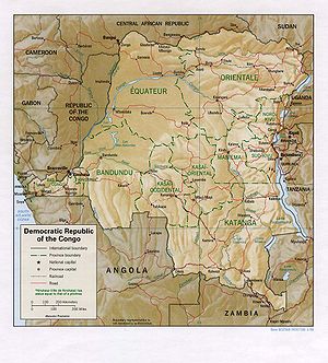
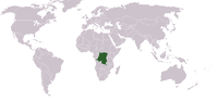
The Democratic Republic of the Congo is a state located in Central Africa. It is the second largest country in Africa by area and the eleventh largest in the world...
includes the greater part of the Congo River
Congo River
The Congo River is a river in Africa, and is the deepest river in the world, with measured depths in excess of . It is the second largest river in the world by volume of water discharged, though it has only one-fifth the volume of the world's largest river, the Amazon...
Basin, which covers an area of almost 1000000 square kilometres (386,102.2 sq mi). The country's only outlet to the Atlantic Ocean
Atlantic Ocean
The Atlantic Ocean is the second-largest of the world's oceanic divisions. With a total area of about , it covers approximately 20% of the Earth's surface and about 26% of its water surface area...
is a narrow strip of land on the north bank of the Congo River.
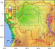
The vast, low-lying central area is a basin-shaped plateau sloping toward the west, covered by tropical rainforest and criss-crossed by rivers, a large area of this has been categorised by the World Wildlife Fund as the Central Congolian lowland forests
Central Congolian lowland forests
The Central Congolian lowland forests are an ecoregion within the Democratic Republic of the Congo. This is a remote, inaccessible area of low-lying dense wet forest, undergrowth and swamp in the Cuvette Centrale region of the Congo Basin south of the arc of the River Congo.-Fauna:The region has...
ecoregion
Ecoregion
An ecoregion , sometimes called a bioregion, is an ecologically and geographically defined area that is smaller than an ecozone and larger than an ecosystem. Ecoregions cover relatively large areas of land or water, and contain characteristic, geographically distinct assemblages of natural...
. The forest centre is surrounded by mountainous terraces in the west, plateaus merging into savannas in the south and southwest, and dense grasslands extending beyond the Congo River in the north. High mountains of the Ruwenzori Range
Ruwenzori Range
The Rwenzori Mountains, previously called the Ruwenzori Range , and sometimes the Mountains of the Moon, is a mountain range of central Africa, often referred to as Mt...
(some above 5000 m (16,404.2 ft)) are found on the eastern borders with Rwanda
Rwanda
Rwanda or , officially the Republic of Rwanda , is a country in central and eastern Africa with a population of approximately 11.4 million . Rwanda is located a few degrees south of the Equator, and is bordered by Uganda, Tanzania, Burundi and the Democratic Republic of the Congo...
and Uganda
Uganda
Uganda , officially the Republic of Uganda, is a landlocked country in East Africa. Uganda is also known as the "Pearl of Africa". It is bordered on the east by Kenya, on the north by South Sudan, on the west by the Democratic Republic of the Congo, on the southwest by Rwanda, and on the south by...
(see Albertine Rift montane forests
Albertine Rift montane forests
The Albertine Rift montane forests ecoregion, of the Tropical moist broadleaf forest Biome, are in the heart of Afromontane tropical Africa.-Location and description:...
for a description of this area).
Climate
The DRC lies on the Equator, with one-third of the country to the north and two-thirds to the south. The climate is hot and humid in the river basin and cool and dry in the southern highlands, with a cold, alpine climate in the Ruwenzori RangeRuwenzori Range
The Rwenzori Mountains, previously called the Ruwenzori Range , and sometimes the Mountains of the Moon, is a mountain range of central Africa, often referred to as Mt...
. There is a South of the Equator, the rainy season lasts from October to May and north of the Equator, from April to November. Along the Equator, rainfall is fairly regular throughout the year. During the wet season, thunderstorms often are violent but seldom last more than a few hours. The average rainfall for the entire country is about 1070 mm (42.1 in).
Data
Location:Central Africa
Africa
Africa is the world's second largest and second most populous continent, after Asia. At about 30.2 million km² including adjacent islands, it covers 6% of the Earth's total surface area and 20.4% of the total land area...
, northeast of Angola
Angola
Angola, officially the Republic of Angola , is a country in south-central Africa bordered by Namibia on the south, the Democratic Republic of the Congo on the north, and Zambia on the east; its west coast is on the Atlantic Ocean with Luanda as its capital city...
Geographic coordinates: 0°00′N 25°00′E
Map references:
Africa
Area:
total:
2,345,410 km2
land:
2,267,600 km2
water:
77,810 km2
Area - comparative:
slightly less than one-fourth the size of the US
Land boundaries:
total:
10,744 km
border countries:
Angola 2,511 km, Burundi
Burundi
Burundi , officially the Republic of Burundi , is a landlocked country in the Great Lakes region of Eastern Africa bordered by Rwanda to the north, Tanzania to the east and south, and the Democratic Republic of the Congo to the west. Its capital is Bujumbura...
233 km, Central African Republic
Central African Republic
The Central African Republic , is a landlocked country in Central Africa. It borders Chad in the north, Sudan in the north east, South Sudan in the east, the Democratic Republic of the Congo and the Republic of the Congo in the south, and Cameroon in the west. The CAR covers a land area of about ,...
1,577 km, Republic of the Congo
Republic of the Congo
The Republic of the Congo , sometimes known locally as Congo-Brazzaville, is a state in Central Africa. It is bordered by Gabon, Cameroon, the Central African Republic, the Democratic Republic of the Congo , the Angolan exclave province of Cabinda, and the Gulf of Guinea.The region was dominated by...
2,410 km, Rwanda
Rwanda
Rwanda or , officially the Republic of Rwanda , is a country in central and eastern Africa with a population of approximately 11.4 million . Rwanda is located a few degrees south of the Equator, and is bordered by Uganda, Tanzania, Burundi and the Democratic Republic of the Congo...
217 km, South Sudan
South Sudan
South Sudan , officially the Republic of South Sudan, is a landlocked country located in the Sahel region of northeastern Africa. It is also part of the North Africa UN sub-region. Its current capital is Juba, which is also its largest city; the capital city is planned to be moved to the more...
628 km, Tanzania
Tanzania
The United Republic of Tanzania is a country in East Africa bordered by Kenya and Uganda to the north, Rwanda, Burundi, and the Democratic Republic of the Congo to the west, and Zambia, Malawi, and Mozambique to the south. The country's eastern borders lie on the Indian Ocean.Tanzania is a state...
473 km, Uganda
Uganda
Uganda , officially the Republic of Uganda, is a landlocked country in East Africa. Uganda is also known as the "Pearl of Africa". It is bordered on the east by Kenya, on the north by South Sudan, on the west by the Democratic Republic of the Congo, on the southwest by Rwanda, and on the south by...
765 km, Zambia
Zambia
Zambia , officially the Republic of Zambia, is a landlocked country in Southern Africa. The neighbouring countries are the Democratic Republic of the Congo to the north, Tanzania to the north-east, Malawi to the east, Mozambique, Zimbabwe, Botswana and Namibia to the south, and Angola to the west....
1,930 km
Coastline:
37 km (23 mi).
Maritime claims:
exclusive economic zone:
boundaries with neighbors
territorial sea:
12 nmi (22.2 km)
Climate:
tropical; hot and humid in equatorial river basin; cooler and drier in southern highlands; cooler-cold and wetter in eastern highlands and the Ruwenzori Range; north of Equator - wet season April to October, dry season December to February; south of Equator
Equator
An equator is the intersection of a sphere's surface with the plane perpendicular to the sphere's axis of rotation and containing the sphere's center of mass....
- wet season November to March, dry season April to October
vast central plateau covered by tropical rainforest, surrounded by mountains in the west, plains and savanna in the south/southwest, and grasslands in the north. The high mountains of the Ruwenzori Range
Ruwenzori Range
The Rwenzori Mountains, previously called the Ruwenzori Range , and sometimes the Mountains of the Moon, is a mountain range of central Africa, often referred to as Mt...
on the eastern borders.
Elevation extremes:
lowest point:
Atlantic Ocean
Atlantic Ocean
The Atlantic Ocean is the second-largest of the world's oceanic divisions. With a total area of about , it covers approximately 20% of the Earth's surface and about 26% of its water surface area...
0 m
highest point:
Pic Marguerite on Mont Ngaliema (Mount Stanley) 5,110 m
Natural resources:
cobalt
Cobalt
Cobalt is a chemical element with symbol Co and atomic number 27. It is found naturally only in chemically combined form. The free element, produced by reductive smelting, is a hard, lustrous, silver-gray metal....
, copper
Copper
Copper is a chemical element with the symbol Cu and atomic number 29. It is a ductile metal with very high thermal and electrical conductivity. Pure copper is soft and malleable; an exposed surface has a reddish-orange tarnish...
, cadmium
Cadmium
Cadmium is a chemical element with the symbol Cd and atomic number 48. This soft, bluish-white metal is chemically similar to the two other stable metals in group 12, zinc and mercury. Similar to zinc, it prefers oxidation state +2 in most of its compounds and similar to mercury it shows a low...
, petroleum
Petroleum
Petroleum or crude oil is a naturally occurring, flammable liquid consisting of a complex mixture of hydrocarbons of various molecular weights and other liquid organic compounds, that are found in geologic formations beneath the Earth's surface. Petroleum is recovered mostly through oil drilling...
, industrial and gem diamond
Diamond
In mineralogy, diamond is an allotrope of carbon, where the carbon atoms are arranged in a variation of the face-centered cubic crystal structure called a diamond lattice. Diamond is less stable than graphite, but the conversion rate from diamond to graphite is negligible at ambient conditions...
s, gold
Gold
Gold is a chemical element with the symbol Au and an atomic number of 79. Gold is a dense, soft, shiny, malleable and ductile metal. Pure gold has a bright yellow color and luster traditionally considered attractive, which it maintains without oxidizing in air or water. Chemically, gold is a...
, silver
Silver
Silver is a metallic chemical element with the chemical symbol Ag and atomic number 47. A soft, white, lustrous transition metal, it has the highest electrical conductivity of any element and the highest thermal conductivity of any metal...
, zinc
Zinc
Zinc , or spelter , is a metallic chemical element; it has the symbol Zn and atomic number 30. It is the first element in group 12 of the periodic table. Zinc is, in some respects, chemically similar to magnesium, because its ion is of similar size and its only common oxidation state is +2...
, manganese
Manganese
Manganese is a chemical element, designated by the symbol Mn. It has the atomic number 25. It is found as a free element in nature , and in many minerals...
, tin
Tin
Tin is a chemical element with the symbol Sn and atomic number 50. It is a main group metal in group 14 of the periodic table. Tin shows chemical similarity to both neighboring group 14 elements, germanium and lead and has two possible oxidation states, +2 and the slightly more stable +4...
, germanium
Germanium
Germanium is a chemical element with the symbol Ge and atomic number 32. It is a lustrous, hard, grayish-white metalloid in the carbon group, chemically similar to its group neighbors tin and silicon. The isolated element is a semiconductor, with an appearance most similar to elemental silicon....
, uranium
Uranium
Uranium is a silvery-white metallic chemical element in the actinide series of the periodic table, with atomic number 92. It is assigned the chemical symbol U. A uranium atom has 92 protons and 92 electrons, of which 6 are valence electrons...
, radium
Radium
Radium is a chemical element with atomic number 88, represented by the symbol Ra. Radium is an almost pure-white alkaline earth metal, but it readily oxidizes on exposure to air, becoming black in color. All isotopes of radium are highly radioactive, with the most stable isotope being radium-226,...
, bauxite
Bauxite
Bauxite is an aluminium ore and is the main source of aluminium. This form of rock consists mostly of the minerals gibbsite Al3, boehmite γ-AlO, and diaspore α-AlO, in a mixture with the two iron oxides goethite and hematite, the clay mineral kaolinite, and small amounts of anatase TiO2...
, iron
Iron
Iron is a chemical element with the symbol Fe and atomic number 26. It is a metal in the first transition series. It is the most common element forming the planet Earth as a whole, forming much of Earth's outer and inner core. It is the fourth most common element in the Earth's crust...
ore, coal
Coal
Coal is a combustible black or brownish-black sedimentary rock usually occurring in rock strata in layers or veins called coal beds or coal seams. The harder forms, such as anthracite coal, can be regarded as metamorphic rock because of later exposure to elevated temperature and pressure...
, hydropower
Hydropower
Hydropower, hydraulic power, hydrokinetic power or water power is power that is derived from the force or energy of falling water, which may be harnessed for useful purposes. Since ancient times, hydropower has been used for irrigation and the operation of various mechanical devices, such as...
, timber
Land use:
arable land:
2.96% (1998 est), 3% (1993 est.)
permanent crops:
0.52% (1998 est.), 0% (1993 est.)
permanent pastures:
7% (1993 est.)
forests and woodland:
77% (1993 est.)
other:
96.52 (1998 est.), 13% (1993 est.)
Irrigated land:
110 km2 (1998 est.), 100 km2 (1993 est.)
Natural hazards:
periodic drought
Drought
A drought is an extended period of months or years when a region notes a deficiency in its water supply. Generally, this occurs when a region receives consistently below average precipitation. It can have a substantial impact on the ecosystem and agriculture of the affected region...
s in south; Congo River
Congo River
The Congo River is a river in Africa, and is the deepest river in the world, with measured depths in excess of . It is the second largest river in the world by volume of water discharged, though it has only one-fifth the volume of the world's largest river, the Amazon...
floods (seasonal); in the east, in the Great Rift Valley
Great Rift Valley
The Great Rift Valley is a name given in the late 19th century by British explorer John Walter Gregory to the continuous geographic trench, approximately in length, that runs from northern Syria in Southwest Asia to central Mozambique in South East Africa...
, there are active volcano
Volcano
2. Bedrock3. Conduit 4. Base5. Sill6. Dike7. Layers of ash emitted by the volcano8. Flank| 9. Layers of lava emitted by the volcano10. Throat11. Parasitic cone12. Lava flow13. Vent14. Crater15...
es
Environment - current issues:
poaching threatens wildlife populations (for example, the Painted Hunting Dog, Lycaon pictus is now considered extinct in the Congo due to human overpopulation
Overpopulation
Overpopulation is a condition where an organism's numbers exceed the carrying capacity of its habitat. The term often refers to the relationship between the human population and its environment, the Earth...
and poaching); water pollution; deforestation (chiefly due to land conversion to agriculture by indigenous farmers); refugees responsible for significant deforestation, soil erosion, and wildlife poaching; mining of minerals (coltan
Coltan
Coltan is the industrial name for columbite–tantalite, a dull black metallic mineral from which the elements niobium and tantalum are extracted. The niobium-dominant mineral is columbite, hence the "col" half of the term...
— a mineral used in creating capacitors, diamonds, and gold) causing environmental damage
Environment - international agreements:
party to:
Biodiversity, Climate Change, Desertification, Endangered Species, Hazardous Wastes, Law of the Sea, Marine Dumping, Nuclear Test Ban, Ozone Layer Protection, Tropical Timber 83, Tropical Timber 94, Wetlands
signed, but not ratified:
Environmental Modification
Geography:
straddles Equator
Equator
An equator is the intersection of a sphere's surface with the plane perpendicular to the sphere's axis of rotation and containing the sphere's center of mass....
; very narrow strip of land that controls the lower Congo River
Congo River
The Congo River is a river in Africa, and is the deepest river in the world, with measured depths in excess of . It is the second largest river in the world by volume of water discharged, though it has only one-fifth the volume of the world's largest river, the Amazon...
and is the only outlet to South Atlantic Ocean
Atlantic Ocean
The Atlantic Ocean is the second-largest of the world's oceanic divisions. With a total area of about , it covers approximately 20% of the Earth's surface and about 26% of its water surface area...
; dense tropical rainforest
Rainforest
Rainforests are forests characterized by high rainfall, with definitions based on a minimum normal annual rainfall of 1750-2000 mm...
in central river basin and eastern highlands
Extreme points
This is a list of the extreme points of the Democratic Republic of the CongoDemocratic Republic of the Congo
The Democratic Republic of the Congo is a state located in Central Africa. It is the second largest country in Africa by area and the eleventh largest in the world...
, the points that are farther north, south, east or west than any other location.
- Northern-most point - unnamed location on the border with the Central African RepublicCentral African RepublicThe Central African Republic , is a landlocked country in Central Africa. It borders Chad in the north, Sudan in the north east, South Sudan in the east, the Democratic Republic of the Congo and the Republic of the Congo in the south, and Cameroon in the west. The CAR covers a land area of about ,...
in the Bomu river immediately west of the town of Mbaga in CAR, Orientale Province - Eastern-most point - at the point where the northern section of the border with Uganda enters Lake Albert immediately west of Mahagi Port, Oritentale Province
- Southern-most point - unnamed location on the border with ZambiaZambiaZambia , officially the Republic of Zambia, is a landlocked country in Southern Africa. The neighbouring countries are the Democratic Republic of the Congo to the north, Tanzania to the north-east, Malawi to the east, Mozambique, Zimbabwe, Botswana and Namibia to the south, and Angola to the west....
immediately to north-west of the Zambian town of Ndabala, KatangaKatanga ProvinceKatanga Province is one of the provinces of the Democratic Republic of the Congo. Between 1971 and 1997, its official name was Shaba Province. Under the new constitution, the province was to be replaced by four smaller provinces by February 2009; this did not actually take place.Katanga's regional...
province - Western-most point - the point at which the border with CabindaCabindaCabinda may refer to:*Cabinda Province, an exclave and Province of Angola*Cabinda , the administrative capital of Cabinda Province*Republic of Cabinda, self-proclaimed government which claims sovereignty over Cabinda...
enters the Atlantic OceanAtlantic OceanThe Atlantic Ocean is the second-largest of the world's oceanic divisions. With a total area of about , it covers approximately 20% of the Earth's surface and about 26% of its water surface area...
, Bas-CongoBas-CongoBas-Congo is one of the eleven provinces of the Democratic Republic of the Congo. It is the only province with a coastline and it borders Bandundu province to the east and Kinshasa to the northeast...
province