

Geography of Venezuela
Encyclopedia
Venezuela
Venezuela , officially called the Bolivarian Republic of Venezuela , is a tropical country on the northern coast of South America. It borders Colombia to the west, Guyana to the east, and Brazil to the south...
is a country in South America, and part of Caribbean South America
Caribbean South America
Caribbean South America is a region of South America consisting of the nations that border the Caribbean Sea, namely:*Colombia*Venezuela...
, bordering the Caribbean Sea
Caribbean Sea
The Caribbean Sea is a sea of the Atlantic Ocean located in the tropics of the Western hemisphere. It is bounded by Mexico and Central America to the west and southwest, to the north by the Greater Antilles, and to the east by the Lesser Antilles....
and the North Atlantic Ocean, between Colombia
Colombia
Colombia, officially the Republic of Colombia , is a unitary constitutional republic comprising thirty-two departments. The country is located in northwestern South America, bordered to the east by Venezuela and Brazil; to the south by Ecuador and Peru; to the north by the Caribbean Sea; to the...
and Guyana
Guyana
Guyana , officially the Co-operative Republic of Guyana, previously the colony of British Guiana, is a sovereign state on the northern coast of South America that is culturally part of the Anglophone Caribbean. Guyana was a former colony of the Dutch and of the British...
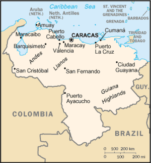
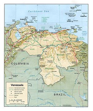
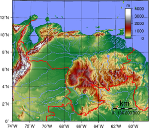
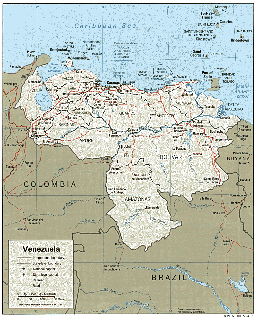
. It is situated on major sea and air routes linking North and South America. Located at the northernmost end of South America, Venezuela has a total area of 916,445 square kilometers and a land area of 882,050 square kilometers, about twice the size of California. Shaped roughly like an inverted triangle, the country has a 2,800-kilometer coastline and is bounded on the north by the Caribbean Sea and the Atlantic Ocean, on the east by Guyana, on the south by Brazil, and on the west by Colombia.
Geographic coordinates: 8°00′N 66°00′W
Topography
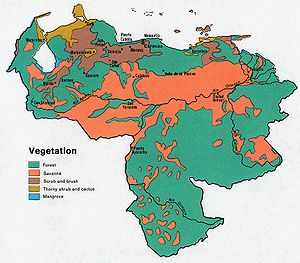
Most observers describe Venezuela in terms of four fairly well-defined regions: the Maracaibo lowlandsMaracaibo Basin
The Maracaibo Basin in Western Venezuela is a prolific, oil-producing sedimentary basin. The basin is bounded on the north by the Oca Fault which separates it from the Caribbean Sea. The remaining sides of the basin are bounded by a branching in the northern Andes Mountains termed the Sierra de...
in the northwest, the northern mountains extending in a broad east-west arc from the Colombian border along the Caribbean Sea, the wide Orinoco plains (llanos
Llanos
The Llanos is a vast tropical grassland plain situated to the east of the Andes in Colombia and Venezuela, in northwestern South America. It is an ecoregion of the Flooded grasslands and savannas Biome....
) in central Venezuela, and rank highly dissected Guiana highlands in the southeast.
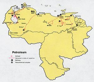
The Maracaibo lowlands form a large spoon-shaped oval bounded by mountains on three sides and open to the Caribbean on the north. The area is remarkably flat with only a gentle slope toward the center and away from the mountains that border the region. Lake Maracaibo occupies much of the lower-lying territory. Areas around the southern part of Lake Maracaibo are swampy, and, despite the rich agricultural land and significant petroleum deposits, the area was still thinly populated in 1990.
Climate
Although the country lies wholly within the tropics, its climate varies from tropical humid to alpine, depending on the elevation, topography, and the direction and intensity of prevailing winds. Seasonal variations are marked less by temperature than by rainfall. Most of the country has a distinct rainy season; the rainy period (May through November) is commonly referred to as winter and the remainder of the year as summer.The country falls into four horizontal temperature zones based primarily on elevation. In the tropical zone—below convert|800 meters—temperatures are hot, with yearly averages ranging between 26 and 28 °C (78.8 and 82.4 °F). The temperate zone ranges between 800 and 2000 m (2,624.7 and 6,561.7 ft) with averages from convert|30|to|45|°C|°F|85; many of Venezuela's cities, including the capital, lie in this region. Colder conditions with temperatures from 9 to 11 °C (48.2 to 51.8 °F) are found in the cool zone between 2000 and 3000 m (6,561.7 and 9,842.5 ft). Pastureland and permanent snowfield with yearly averages below 8 °C (46.4 °F) cover land above 3000 metres (9,843 ft) in the high mountain areas known as the páramos.
Average yearly rainfall amounts in the lowlands and plains range from a semiarid 430 millimetres (16.9 in) in the western part of the Caribbean coastal areas to around 1000 millimetres (39.4 in) in the Orinoco Delta. Rainfall in mountainous areas varies considerably; sheltered valleys receive little rain, but slopes exposed to the northeast trade winds experience heavy rainfall. Caracas averages 750 millimetres (29.5 in) of precipitation annually, more than half of it falling from June through August.
Paleography
The OrinocoOrinoco
The Orinoco is one of the longest rivers in South America at . Its drainage basin, sometimes called the Orinoquia, covers , with 76.3% of it in Venezuela and the remainder in Colombia...
is by far the most important of the more than 1,000 rivers in the country. Flowing more than 2,500 kilometers to the Atlantic from its source in the Guiana highlands at the Brazilian border, the Orinoco is the world's eighth largest river and the largest in South America after the Amazon
Amazon River
The Amazon of South America is the second longest river in the world and by far the largest by waterflow with an average discharge greater than the next seven largest rivers combined...
. Its flow varies substantially by season, with the high water level in August exceeding by as much as thirteen meters the low levels of March and April. During low water periods, the river experiences high and low tides for more than 100 kilometers upstream from Ciudad Guayana
Ciudad Guayana
Ciudad Guayana is a city in Bolívar State, Venezuela. It lies south of the Orinoco, where the river is joined by the Caroní River. The city, officially founded in 1961, is actually composed of the old town of San Félix at the east and the new town of Puerto Ordaz at the west, which lie either...
.
For most of the river's course, the gradient is slight. Downstream from its headwaters, it splits into two; one-third of its flow passes through the Brazo Casiquiare (Casiquiare Channel) into a tributary of the Amazon, and the remainder passes into the main Orinoco channel. This passageway allows vessels with shallow drafts to navigate from the lower Orinoco to the Amazon River system after unloading and reloading on either side of two falls on the Orinoco along the Colombian border.
Most of the rivers rising in the northern mountains are flowing southeastward to the Río Apure, a tributary of the Orinoco. From its headwater, the Apure crosses the llanos in a generally eastward direction. Few rivers flow into it from the poorly drained region south of the river and much of this area near the Colombian border is swampland.
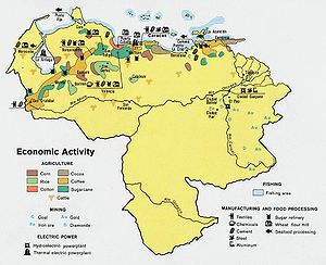
The other major Venezuelan river is the fast-flowing Caroní, which originates in the Guiana highlands and flows northward into the Orinoco upstream from Ciudad Guyana. The Caroní is capable of producing as much hydroelectric power as any river in Latin America and has contributed significantly to the nation's electric power production. Electricity generated by the Caroní was one of the factors encouraging industrialization of the northern part of the Guiana highlands and the lower Orinoco valley.
Lake Maracaibo
Lake Maracaibo
Lake Maracaibo is a large brackish bay in Venezuela at . It is connected to the Gulf of Venezuela by Tablazo Strait at the northern end, and fed by numerous rivers, the largest being the Catatumbo. It is commonly considered a lake rather than a bay or lagoon, and at 13,210 km² it would be the...
, the largest lake in Latin America, occupies the central 13,500 square kilometers of the Maracaibo lowlands. The low swampy shores of the lake and areas beneath the lake itself hold most of Venezuela's rich petroleum deposits. The lake is shallow, with an average depth of ten meters, and separated from the Caribbean by a series of islands and sandbars. In 1955 a 7.5-meter channel was cut through the sandbars to facilitate shipping between the lake and the Caribbean. The channel also allows salt water to mix with the yellowish fresh water of the lake, making the northern parts brackish and unsuited for drinking or irrigation.
Antipodes
The llanos of Venezuela, along the course of the ApureApure River
The Apure River is a river of southwestern Venezuela, formed by the confluence of the Sarare and Uribante near Guasdualito, in Venezuela, at , and flowing across the llanos into the Orinoco...
and Orinoco rivers, are antipodal
Antipodes
In geography, the antipodes of any place on Earth is the point on the Earth's surface which is diametrically opposite to it. Two points that are antipodal to one another are connected by a straight line running through the centre of the Earth....
to central Indonesia
Indonesia
Indonesia , officially the Republic of Indonesia , is a country in Southeast Asia and Oceania. Indonesia is an archipelago comprising approximately 13,000 islands. It has 33 provinces with over 238 million people, and is the world's fourth most populous country. Indonesia is a republic, with an...
, specifically the islands of Bali
Bali
Bali is an Indonesian island located in the westernmost end of the Lesser Sunda Islands, lying between Java to the west and Lombok to the east...
, Lombok
Lombok
Lombok is an island in West Nusa Tenggara province, Indonesia. It forms part of the chain of the Lesser Sunda Islands, with the Lombok Strait separating it from Bali to the west and the Alas Strait between it and Sumbawa to the east...
, Sumbawa
Sumbawa
Sumbawa is an Indonesian island, located in the middle of the Lesser Sunda Islands chain, with Lombok to the west, Flores to the east, and Sumba further to the southeast. It is in the province of West Nusa Tenggara....
, Madura
Madura
Madura is an Indonesian island off the northeastern coast of Java. The island comprises an area of approximately 4,250 km². Madura is administered as part of the East Java province. It is separated from Java by the narrow Strait of Madura.-History:...
, and most of Java
Java
Java is an island of Indonesia. With a population of 135 million , it is the world's most populous island, and one of the most densely populated regions in the world. It is home to 60% of Indonesia's population. The Indonesian capital city, Jakarta, is in west Java...
. The Amazonian southern lobe of the country, mostly south of the Guiana Highlands, is antipodal to the southeastern corner of Borneo
Borneo
Borneo is the third largest island in the world and is located north of Java Island, Indonesia, at the geographic centre of Maritime Southeast Asia....
.
Although not overlapping with the large Javanese cities of Jakarta and Bandung, which are opposite Colombia, Java from Semarang
Semarang
- Economy :The western part of the city is home to many industrial parks and factories. The port of Semarang is located on the north coast and it is the main shipping port for the province of Central Java. Many small manufacturers are located in Semarang, producing goods such as textiles,...
east on the north coast, and south of Bandung on the south coast, correlates to Venezuela. The largest Venezuelan city corresponding to Java is San Fernando de Apure
San Fernando de Apure
San Fernando de Apure is a city in Apure State in Venezuela. The population of the municipality area is 175,056 . The 18th century exports included heron feathers and animal hides....
(within a couple kilometers of antipodal to the large city of Malang
Malang
Malang is the second largest city in East Java province, Indonesia. It has an ancient history dating back to the Mataram Kingdom. The city population at the 2010 Census was 819,708. During the period of Dutch colonization, it was a popular destination for European residents. The city is famous for...
), though San Cristóbal comes close, within a few kilometers of the Javanese coast.
El Tigre
El Tigre
El Tigre is a city in the eastern Venezuelan state of Anzoátegui. This city is the shire town of the Simón Rodríguez Municipality and, according to the 2001 Venezuelan census, the municipality has a population of 147,800.-History:...
is opposite the Wallace Line
Wallace Line
The Wallace Line separates the ecozones of Asia and Wallacea, a transitional zone between Asia and Australia. West of the line are found organisms related to Asiatic species; to the east, a mixture of species of Asian and Australian origin is present...
between Bali and Lombok. Sumbawa corresponds to the Orinoco delta, and almost to Ciudad Guayana
Ciudad Guayana
Ciudad Guayana is a city in Bolívar State, Venezuela. It lies south of the Orinoco, where the river is joined by the Caroní River. The city, officially founded in 1961, is actually composed of the old town of San Félix at the east and the new town of Puerto Ordaz at the west, which lie either...
.