

Geography of Togo
Encyclopedia
Togo
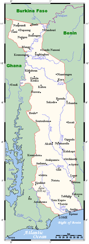
Togo, officially the Togolese Republic , is a country in West Africa bordered by Ghana to the west, Benin to the east and Burkina Faso to the north. It extends south to the Gulf of Guinea, on which the capital Lomé is located. Togo covers an area of approximately with a population of approximately...
is a small Sub-Saharan
Sub-Saharan Africa
Sub-Saharan Africa as a geographical term refers to the area of the African continent which lies south of the Sahara. A political definition of Sub-Saharan Africa, instead, covers all African countries which are fully or partially located south of the Sahara...
nation comprising a long strip of land in West Africa
West Africa
West Africa or Western Africa is the westernmost region of the African continent. Geopolitically, the UN definition of Western Africa includes the following 16 countries and an area of approximately 5 million square km:-Flags of West Africa:...
. Togo's geographic coordinates
Geographic coordinate system
A geographic coordinate system is a coordinate system that enables every location on the Earth to be specified by a set of numbers. The coordinates are often chosen such that one of the numbers represent vertical position, and two or three of the numbers represent horizontal position...
are a latitude
Latitude
In geography, the latitude of a location on the Earth is the angular distance of that location south or north of the Equator. The latitude is an angle, and is usually measured in degrees . The equator has a latitude of 0°, the North pole has a latitude of 90° north , and the South pole has a...
of 8° north and a longitude
Longitude
Longitude is a geographic coordinate that specifies the east-west position of a point on the Earth's surface. It is an angular measurement, usually expressed in degrees, minutes and seconds, and denoted by the Greek letter lambda ....
of 1°10′ east. It is bordered by three countries: Benin
Benin
Benin , officially the Republic of Benin, is a country in West Africa. It borders Togo to the west, Nigeria to the east and Burkina Faso and Niger to the north. Its small southern coastline on the Bight of Benin is where a majority of the population is located...
to the east, with 644 km (400 mi) of border; Burkina Faso
Burkina Faso
Burkina Faso – also known by its short-form name Burkina – is a landlocked country in west Africa. It is surrounded by six countries: Mali to the north, Niger to the east, Benin to the southeast, Togo and Ghana to the south, and Côte d'Ivoire to the southwest.Its size is with an estimated...
to the north, with 126 km (78 mi) of border; and Ghana
Ghana
Ghana , officially the Republic of Ghana, is a country located in West Africa. It is bordered by Côte d'Ivoire to the west, Burkina Faso to the north, Togo to the east, and the Gulf of Guinea to the south...
, with 877 km (545 mi) of border. To the south Togo has 56 km (35 mi) of coastline along the Bight of Benin
Bight of Benin
The Bight of Benin is a bight on the western African coast that extends eastward for about 400 miles from Cape St. Paul to the Nun outlet of the Niger River. To the east it is continued by the Bight of Bonny . The bight is part of the Gulf of Guinea...
of the Gulf of Guinea
Gulf of Guinea
The Gulf of Guinea is the northeasternmost part of the tropical Atlantic Ocean between Cape Lopez in Gabon, north and west to Cape Palmas in Liberia. The intersection of the Equator and Prime Meridian is in the gulf....
in the North Atlantic Ocean
Atlantic Ocean
The Atlantic Ocean is the second-largest of the world's oceanic divisions. With a total area of about , it covers approximately 20% of the Earth's surface and about 26% of its water surface area...
. Togo stretches 579 km (360 mi) north from the Gulf and is only 160 km (99 mi) wide at the broadest point. In total, Togo has an area of 56785 km² (21,925 sq mi), of which 54385 km² (20,998 sq mi) is land and 2400 km² (927 sq mi) is water.
The country consists primarily of two savanna
Savanna
A savanna, or savannah, is a grassland ecosystem characterized by the trees being sufficiently small or widely spaced so that the canopy does not close. The open canopy allows sufficient light to reach the ground to support an unbroken herbaceous layer consisting primarily of C4 grasses.Some...
plains regions separated by a southwest–northeast range of hills (the Chaîne du Togo).
Togo
Togo
Togo, officially the Togolese Republic , is a country in West Africa bordered by Ghana to the west, Benin to the east and Burkina Faso to the north. It extends south to the Gulf of Guinea, on which the capital Lomé is located. Togo covers an area of approximately with a population of approximately...
is commonly divided into six geographic regions. In the south are low-lying sandy beaches. The coastal region is narrow and followed by tidal flats and shallow lagoon
Lagoon
A lagoon is a body of shallow sea water or brackish water separated from the sea by some form of barrier. The EU's habitat directive defines lagoons as "expanses of shallow coastal salt water, of varying salinity or water volume, wholly or partially separated from the sea by sand banks or shingle,...
s. There are also a number of lakes, the largest of which is Lake Togo
Lake Togo
Lake Togo is the largest part of a lagoon in Togo, separated from the head by a narrow coastal strip. It is shallow and a popular location for water sports. Towns on the lake's shore include Agbodrafo and Togoville. The name is derived from to, which means "water", and go, which means "edge" or...
.
Further north lies the Ouatchi Plateau
Ouatchi Plateau
The Ouatchi Plateau is a tableland in southern central Togo, West Africa. The plateau is also known as Terre de barre after its reddish, iron-rich soil. The plateau is about 30 kilometres wide and located at an altitude of 60 to 90 metres above sea level....
. This plateau is about 30 kilometres (19 mi) wide and located at an altitude of 60 to 90 m (196.9 to 295.3 ft) above sea level. Terre de Barre is another name for this region, in use because of the reddish leached soil which is rich in iron. This southern area of Togo has been categorised by the World Wildlife Fund as part of the Guinean forest-savanna mosaic
Guinean forest-savanna mosaic
The Guinean forest-savanna mosaic is an ecoregion of West Africa, a band of interlaced forest, savanna, and grassland running east to west and dividing the tropical moist forests near the coast from the West Sudanian savanna of the interior.-Setting:...
ecoregion
Ecoregion
An ecoregion , sometimes called a bioregion, is an ecologically and geographically defined area that is smaller than an ecozone and larger than an ecosystem. Ecoregions cover relatively large areas of land or water, and contain characteristic, geographically distinct assemblages of natural...
.
Northeast of the Ouatchi Plateau lies a tableland. At its highest this region is about 500 metres (1,640 ft) above sea level. The area is drained by the Mono River
Mono River
The Mono River is the major river of eastern Togo.Approximately long, and draining a basin of about , it rises between the town of Sokodé and the border with Benin, and flows south. Along the southern portion of the river towards its mouth, it forms the international boundary between Togo and Benin...
and its tributaries, including the Ogou River.
To the west and the southwest of the tableland lie the Togo Mountains
Togo Mountains
The Togo Mountains is a mountain range which stretches across the central region of the West African country of Togo and across the eastern and western borders of that country into Ghana and Benin. In Ghana, the range is also known as the Akwapim Hills, and in Benin it is also known as the Atakora...
. These mountains run across the central region of Togo, ranging from the southwest to the northeast. The mountain range reaches into Benin
Benin
Benin , officially the Republic of Benin, is a country in West Africa. It borders Togo to the west, Nigeria to the east and Burkina Faso and Niger to the north. Its small southern coastline on the Bight of Benin is where a majority of the population is located...
where it is known as the Atakora Mountains and Ghana
Ghana
Ghana , officially the Republic of Ghana, is a country located in West Africa. It is bordered by Côte d'Ivoire to the west, Burkina Faso to the north, Togo to the east, and the Gulf of Guinea to the south...
where it is known as the Akwapim Hills. The highest mountain in Togo is Mount Agou
Mount Agou
Mount Agou is the highest mountain in Togo at 986 metres . Near the Ghana border, it lies to the south east of Kpalimé in the Plateaux Region of Togo. Mount Agou is part of an extreme western outlier of the Atakora Mountains of adjacent Benin. Its summit is topped by an antenna....
with a height of 986 metres (3,235 ft).
North of the Togo Mountains lies a sandstone plateau through which the Oti River
Oti River
The Oti River is a river in West Africa that rises in Burkina Faso. It forms part of the international boundaries between Benin and Burkina Faso and between Togo and Ghana. It empties into Lake Volta....
flows. The vegetation is characterized by savanna. The River Oti which drains the plateau is one of the main tributaries of the River Volta.
In the far northwest of Togo lies a higher region which is characterized by its rocks: granite
Granite
Granite is a common and widely occurring type of intrusive, felsic, igneous rock. Granite usually has a medium- to coarse-grained texture. Occasionally some individual crystals are larger than the groundmass, in which case the texture is known as porphyritic. A granitic rock with a porphyritic...
and gneiss
Gneiss
Gneiss is a common and widely distributed type of rock formed by high-grade regional metamorphic processes from pre-existing formations that were originally either igneous or sedimentary rocks.-Etymology:...
. The cliffs of Dapaong
Dapaong
Dapaong is a city in northern Togo and prefecture seat of Tône in the Savanes Region. It is situated 638 km north of the capital Lomé, near the border with Burkina Faso. It is a market town and has a small museum....
(Dapango) are located in this part of Togo.
Land use
- Natural resources: phosphates, limestoneLimestoneLimestone is a sedimentary rock composed largely of the minerals calcite and aragonite, which are different crystal forms of calcium carbonate . Many limestones are composed from skeletal fragments of marine organisms such as coral or foraminifera....
, marbleMarbleMarble is a metamorphic rock composed of recrystallized carbonate minerals, most commonly calcite or dolomite.Geologists use the term "marble" to refer to metamorphosed limestone; however stonemasons use the term more broadly to encompass unmetamorphosed limestone.Marble is commonly used for...
, arable land - Land use:
- arable land: 32%
- permanent crops: 7%
- permanent pastures: 4%
- forests and woodland: 17%
- other: 34% (1993 est.)
- Natural hazards: hot, dry HarmattanHarmattanThe Harmattan is a dry and dusty West African trade wind. It blows south from the Sahara into the Gulf of Guinea between the end of November and the middle of March...
wind can reduce visibility in north during winter; periodic droughts.
Climate
The climate is generally tropical with average temperatures ranging from 27.5 °C (81.5 °F) on the coast to about 30 °C (86 °F) in the northernmost regions, with a dry climate and characteristics of a tropical savanna. To the south there are two seasons of rain (the first between April and July and the second between (September and November), even though the average rainfall is not very high.The climate is tropical and humid for seven months while the dry desert winds of the harmatten blow south from November to March, bringing cooler weather.
Environment
Current issues:- deforestation attributable to slash-and-burn agriculture and the use of wood for fuel
- recent droughts affecting agriculture
International agreements: Togo is party to: Biodiversity
Biodiversity
Biodiversity is the degree of variation of life forms within a given ecosystem, biome, or an entire planet. Biodiversity is a measure of the health of ecosystems. Biodiversity is in part a function of climate. In terrestrial habitats, tropical regions are typically rich whereas polar regions...
, Climate Change
United Nations Framework Convention on Climate Change
The United Nations Framework Convention on Climate Change is an international environmental treaty produced at the United Nations Conference on Environment and Development , informally known as the Earth Summit, held in Rio de Janeiro from June 3 to 14, 1992...
, Desertification
Desertification
Desertification is the degradation of land in drylands. Caused by a variety of factors, such as climate change and human activities, desertification is one of the most significant global environmental problems.-Definitions:...
, Endangered Species
Endangered species
An endangered species is a population of organisms which is at risk of becoming extinct because it is either few in numbers, or threatened by changing environmental or predation parameters...
, Law of the Sea
Law of the sea
Law of the sea may refer to:* United Nations Convention on the Law of the Sea* Admiralty law* The Custom of the Sea...
, Marine Dumping, Nuclear Test Ban, Ozone Layer Protection, Ship Pollution (MARPOL 73/78
MARPOL 73/78
Marpol 73/78 is the International Convention for the Prevention of Pollution From Ships, 1973 as modified by the Protocol of 1978....
), Tropical Timber 83, Tropical Timber 94, Wetlands
Extreme points
This is a list of the extreme points of TogoTogo
Togo, officially the Togolese Republic , is a country in West Africa bordered by Ghana to the west, Benin to the east and Burkina Faso to the north. It extends south to the Gulf of Guinea, on which the capital Lomé is located. Togo covers an area of approximately with a population of approximately...
, the points that are farther north, south, east or west than any other location.
- Northern-most point – the tripointTripointA tripoint, or trijunction , is a geographical point at which the borders of three countries or subnational entities meet....
with GhanaGhanaGhana , officially the Republic of Ghana, is a country located in West Africa. It is bordered by Côte d'Ivoire to the west, Burkina Faso to the north, Togo to the east, and the Gulf of Guinea to the south...
and Burkina FasoBurkina FasoBurkina Faso – also known by its short-form name Burkina – is a landlocked country in west Africa. It is surrounded by six countries: Mali to the north, Niger to the east, Benin to the southeast, Togo and Ghana to the south, and Côte d'Ivoire to the southwest.Its size is with an estimated...
, Savanes RegionSavanes Region, TogoSavanes is the northernmost of the five Regions of Togo. Dapaong is the regional capital. Another major town in the region is Mango.Savanes is divided into the prefectures of Kpendjal, Oti, Tandjouaré, and Tône.... - Eastern-most point – unnamed location on the border with BeninBeninBenin , officially the Republic of Benin, is a country in West Africa. It borders Togo to the west, Nigeria to the east and Burkina Faso and Niger to the north. Its small southern coastline on the Bight of Benin is where a majority of the population is located...
in the Mono riverMono RiverThe Mono River is the major river of eastern Togo.Approximately long, and draining a basin of about , it rises between the town of Sokodé and the border with Benin, and flows south. Along the southern portion of the river towards its mouth, it forms the international boundary between Togo and Benin...
immediately west of the Beninese town of Grand-PopoGrand-PopoGrand-Popo is a town, arrondissement, and commune in the Mono Department of south-western Benin. The commune covers an area of 289 square kilometres and as of 2002 had a population of 40,335 people....
, Maritime RegionMaritime RegionMaritime is the southernmost of Togo's five regions, with the country's only shoreline on the Bight of Benin. Lomé serves as both the regional and national capital... - Southern-most point – the point at which the border with GhanaGhanaGhana , officially the Republic of Ghana, is a country located in West Africa. It is bordered by Côte d'Ivoire to the west, Burkina Faso to the north, Togo to the east, and the Gulf of Guinea to the south...
enters the Atlantic OceanAtlantic OceanThe Atlantic Ocean is the second-largest of the world's oceanic divisions. With a total area of about , it covers approximately 20% of the Earth's surface and about 26% of its water surface area...
, Maritime RegionMaritime RegionMaritime is the southernmost of Togo's five regions, with the country's only shoreline on the Bight of Benin. Lomé serves as both the regional and national capital... - Western-most point - the tripointTripointA tripoint, or trijunction , is a geographical point at which the borders of three countries or subnational entities meet....
with GhanaGhanaGhana , officially the Republic of Ghana, is a country located in West Africa. It is bordered by Côte d'Ivoire to the west, Burkina Faso to the north, Togo to the east, and the Gulf of Guinea to the south...
and Burkina FasoBurkina FasoBurkina Faso – also known by its short-form name Burkina – is a landlocked country in west Africa. It is surrounded by six countries: Mali to the north, Niger to the east, Benin to the southeast, Togo and Ghana to the south, and Côte d'Ivoire to the southwest.Its size is with an estimated...
, Savanes RegionSavanes Region, TogoSavanes is the northernmost of the five Regions of Togo. Dapaong is the regional capital. Another major town in the region is Mango.Savanes is divided into the prefectures of Kpendjal, Oti, Tandjouaré, and Tône....