
Geography of Saint Petersburg
Encyclopedia
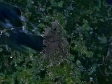
Saint Petersburg is a city and a federal subject
located in Northwestern Federal District
of Russia
on the Neva River
at the east end of the Gulf of Finland
on the Baltic Sea
.
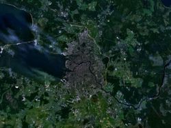
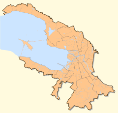
 As of now the area of the city of Saint Petersburg
proper is 605.8 km². As a federal subject Saint Petersburg contains, besides Saint Petersburg proper, a number of towns (Kolpino
, Krasnoye Selo
, Kronstadt
, Lomonosov
, Pavlovsk, Petergof, Pushkin
, Sestroretsk
and Zelenogorsk
), 21 municipal settlements, as well as rural localities. The total territory of the federal subject as of now comprises 1439 km².
The federal subject and city of Saint Petersburg is situated on the middle taiga
lowlands along the shores of the Neva Bay of the Gulf of Finland
, along the shores of the lower reaches of the River Neva itself and on the numerous islands of the river delta. Vasilyevsky island is the largest of them (not counting the unnamed artificial island formed by Obvodny canal
and Fontanka
and the island Kotlin of the Neva Bay), followed by Petrogradsky, Dekabristov and Krestovsky
. The latter together with Yelagin
and Kamenny island
forms the so-called Kirovskiye islands, covered mostly by parks.
To the north of the city lies the Karelian Isthmus
, a popular area of summer resort for its citizens, while in the south Saint Petersburg crosses the Baltic-Ladoga Klint and meets the Izhora Plateau
.
The elevation of Saint Petersburg ranges from the sea level
to its highest point of 175.9 m (577') at the Orekhovaya hill in the Duderhof Heights
in the south. However, the historical city center (except the area between Liteyny Prospekt
and Smolnaya Embankment) is situated lower than 4 m and has suffered from flooding about 300 times in its history. Floods in Saint Petersburg
are triggered by a long wave in the Baltic Sea, developing regularly under some meteorological conditions and amplified by favorable winds and shallowness of the Neva Bay. The most disastrous floods occurred in 1824 (421 cm above sea-level), 1924 (380 cm), 1777 (321 cm), 1955 (293 cm) and 1975 (281 cm.). The Saint Petersburg Dam
to prevent floods was completed in August 2011, after a lengthy period of construction beginning in 1979.
Since the 18th century the terrain in the city centre has been steadily raised artificially, at some places by more than 4 m. The hydrology of the city center and the number of islands have also changed dramatically.
Besides Neva and its distributaries, other important rivers of the federal subject of Saint Petersburg are Sestra
, Okhta and Izhora
. The largest lake is Sestroretsky Razliv in the north, outside of the limits of Saint Petersburg proper. Lakhtinsky Razliv and Suzdal Lakes are smaller lakes within the northern limits of the city.
St. Petersburg's position on the latitude
of ca. 60° N, less than seven degrees to the south of the Arctic Circle
, leads to a huge variation in day length
across seasons, ranging from 5:53 to 18:50, and causes twilight
to last all night in early summer, from June to mid-July, the celebrated phenomenon known as the white nights.
 Saint Petersburg experiences a humid continental climate
of the cool summer subtype (Köppen: Dfb), due to the distinct moderating influence of the Baltic Sea
cyclones. Summers are typically cool, humid and quite short, while winters are long, cold, but with frequent warm spell
s. The average winter minimum is about -27°C (-17°F), the record low temperature is -35.9°C (-33°F), recorded in 1883. Solid frozen ground is a normal part of winter there. The River Neva within the city limits usually freezes up in November-December, break-up occurs in April. On average there are 123 days with snow cover (stable from December to March), which reaches the average of 24 cm (9.5") by February. The frost-free period in the city lasts on average for about 135 days. There is some temperature variation within the city limits and the city itself experiences a climate slightly warmer than its suburbs. Weather conditions are, however, quite variable all over the year.
The highest temperatures of July and August were reached in 2010.
Average annual precipitation
varies across the city, being about 600–750 mm per year on average and reaching maximum in late summer and in the north. Though this number is not high by itself, soil moisture is almost always excessive because of low evapotranspiration
due to the cool climate. Relative humidity
of air is also high (78% on average), overcast
is common all over the year (165 days a year on average).
Federal subjects of Russia
Russia is a federation which, since March 1, 2008, consists of 83 federal subjects . In 1993, when the Constitution was adopted, there were 89 federal subjects listed...
located in Northwestern Federal District
Northwestern Federal District
Northwestern Federal District is one of the eight federal districts of Russia. It consists of the northern part of European Russia. Its population was 13,583,800 according to the 2010 Census, living on an area of...
of Russia
Russia
Russia or , officially known as both Russia and the Russian Federation , is a country in northern Eurasia. It is a federal semi-presidential republic, comprising 83 federal subjects...
on the Neva River
Neva River
The Neva is a river in northwestern Russia flowing from Lake Ladoga through the western part of Leningrad Oblast to the Neva Bay of the Gulf of Finland. Despite its modest length , it is the third largest river in Europe in terms of average discharge .The Neva is the only river flowing from Lake...
at the east end of the Gulf of Finland
Gulf of Finland
The Gulf of Finland is the easternmost arm of the Baltic Sea. It extends between Finland and Estonia all the way to Saint Petersburg in Russia, where the river Neva drains into it. Other major cities around the gulf include Helsinki and Tallinn...
on the Baltic Sea
Baltic Sea
The Baltic Sea is a brackish mediterranean sea located in Northern Europe, from 53°N to 66°N latitude and from 20°E to 26°E longitude. It is bounded by the Scandinavian Peninsula, the mainland of Europe, and the Danish islands. It drains into the Kattegat by way of the Øresund, the Great Belt and...
.
Saint Petersburg
Saint Petersburg is a city and a federal subject of Russia located on the Neva River at the head of the Gulf of Finland on the Baltic Sea...
proper is 605.8 km². As a federal subject Saint Petersburg contains, besides Saint Petersburg proper, a number of towns (Kolpino
Kolpino
Kolpino is a municipal city in Kolpinsky District of the federal city of St. Petersburg, Russia, located on the Izhora River southeast of St. Petersburg proper. Population: 81,000 ; 8,076 ....
, Krasnoye Selo
Krasnoye Selo
Krasnoye Selo is a municipal town in Krasnoselsky District of the federal city of St. Petersburg, Russia. It is located south-southeast of the city center. Population:...
, Kronstadt
Kronstadt
Kronstadt , also spelled Kronshtadt, Cronstadt |crown]]" and Stadt for "city"); is a municipal town in Kronshtadtsky District of the federal city of St. Petersburg, Russia, located on Kotlin Island, west of Saint Petersburg proper near the head of the Gulf of Finland. Population: It is also...
, Lomonosov
Lomonosov, Russia
Lomonosov is a municipal town in Petrodvortsovy District of the federal city of St. Petersburg, Russia, situated on the southern coast of the Gulf of Finland, west of St. Petersburg proper. Population:...
, Pavlovsk, Petergof, Pushkin
Pushkin (town)
Pushkin is a municipal town in Pushkinsky District of the federal city of St. Petersburg, Russia, located south from the center of St. Petersburg proper, and its train station, Detskoye Selo, is directly connected by railway to the Vitebsky Rail Terminal of the city...
, Sestroretsk
Sestroretsk
Sestroretsk is a municipal town in Kurortny District of the federal city of St. Petersburg, Russia, located on the shores of the Gulf of Finland, the Sestra River and the Sestroretskiy Lake northwest of St. Petersburg...
and Zelenogorsk
Zelenogorsk, Saint Petersburg
Zelenogorsk , ' before 1948, is a municipal town in Kurortny District of the federal city of Saint Petersburg, Russia, located in part of the Karelian Isthmus on the shore of the Gulf of Finland, and a station on the St. Petersburg-Vyborg railroad. It is located about northwest of central Saint...
), 21 municipal settlements, as well as rural localities. The total territory of the federal subject as of now comprises 1439 km².
The federal subject and city of Saint Petersburg is situated on the middle taiga
Taiga
Taiga , also known as the boreal forest, is a biome characterized by coniferous forests.Taiga is the world's largest terrestrial biome. In North America it covers most of inland Canada and Alaska as well as parts of the extreme northern continental United States and is known as the Northwoods...
lowlands along the shores of the Neva Bay of the Gulf of Finland
Gulf of Finland
The Gulf of Finland is the easternmost arm of the Baltic Sea. It extends between Finland and Estonia all the way to Saint Petersburg in Russia, where the river Neva drains into it. Other major cities around the gulf include Helsinki and Tallinn...
, along the shores of the lower reaches of the River Neva itself and on the numerous islands of the river delta. Vasilyevsky island is the largest of them (not counting the unnamed artificial island formed by Obvodny canal
Obvodny Canal
Obvodny Canal is the longest canal in Saint Petersburg, Russia, which in the 19th century served as the southern limit of the city. It is 8 km long and flows from the Neva River near Alexander Nevsky Lavra to the Yekaterinhofka not far from the sea port. The canal was dug in 1769-1780 and 1805-1833...
and Fontanka
Fontanka
Fontanka is a left branch of the river Neva, which flows through the whole of Central Saint Petersburg, Russia. Its length is 6,700 meters, its width is up to 70 meters, and its depth is up to 3,5 meters. The Fontanka Embankment is lined with the former private residences of Russian nobility.This...
and the island Kotlin of the Neva Bay), followed by Petrogradsky, Dekabristov and Krestovsky
Krestovsky Island
Krestovsky Island is a 3.4 km² island in Saint Petersburg, Russia, situated between several tributaries of the Neva: the Srednyaya Nevka, the Malaya Nevka and the Krestovka. The island is served by the Krestovsky Ostrov "Крестовский остров" station of Saint Petersburg Metro...
. The latter together with Yelagin
Yelagin Island
Yelagin Island is an island at the mouth of the Neva River which is part of St. Petersburg, Russia. Yelagin Island is home to the Yelagin Palace but has few other buildings; the island initially served as a wooded retreat for the ruling class...
and Kamenny island
Kamenny Island
Kamenny Ostrov, Kamenny Island, or Stony Island is one of the islands in the Neva delta. It is part of Saint Petersburg, Russia....
forms the so-called Kirovskiye islands, covered mostly by parks.
To the north of the city lies the Karelian Isthmus
Karelian Isthmus
The Karelian Isthmus is the approximately 45–110 km wide stretch of land, situated between the Gulf of Finland and Lake Ladoga in northwestern Russia, to the north of the River Neva . Its northwestern boundary is the relatively narrow area between the Bay of Vyborg and Lake Ladoga...
, a popular area of summer resort for its citizens, while in the south Saint Petersburg crosses the Baltic-Ladoga Klint and meets the Izhora Plateau
Izhora Plateau
The Izhora Plateau is an elevated landform on Ordovician limestone bedrock in the southwestern part of Leningrad Oblast, between the Gulf of Finland in the north and the Luga River in the south. Its northern edge is formed by the erosional cliff known as the Baltic-Ladoga Klint...
.
The elevation of Saint Petersburg ranges from the sea level
Sea level
Mean sea level is a measure of the average height of the ocean's surface ; used as a standard in reckoning land elevation...
to its highest point of 175.9 m (577') at the Orekhovaya hill in the Duderhof Heights
Duderhof Heights
Duderhof Heights or Duderhof Hills is a small highland area in the southwestern part of Saint Petersburg , to the south of the town of Krasnoye Selo, on the northern edge of the Izhora Plateau, which consists of several hills, most notably, the Orekhovaya hill , the highest point of Saint...
in the south. However, the historical city center (except the area between Liteyny Prospekt
Liteyny Prospekt
Liteyny Avenue is a wide avenue in the Central District of Saint Petersburg, Russia. The avenue runs from Liteyny Bridge to Nevsky Avenue....
and Smolnaya Embankment) is situated lower than 4 m and has suffered from flooding about 300 times in its history. Floods in Saint Petersburg
Floods in Saint Petersburg
Floods in Saint Petersburg refer to a rise of water on the territory of St. Petersburg, a major city in Russia and its former capital. They are usually caused by the overflow of the delta of Neva River and surging water in the eastern part of Neva Bay but sometimes caused by melting snow...
are triggered by a long wave in the Baltic Sea, developing regularly under some meteorological conditions and amplified by favorable winds and shallowness of the Neva Bay. The most disastrous floods occurred in 1824 (421 cm above sea-level), 1924 (380 cm), 1777 (321 cm), 1955 (293 cm) and 1975 (281 cm.). The Saint Petersburg Dam
Saint Petersburg Dam
The Saint Petersburg Flood Prevention Facility Complex , unofficially the Saint Petersburg Dam, is a complex of dams for flood control near Saint Petersburg, Russia...
to prevent floods was completed in August 2011, after a lengthy period of construction beginning in 1979.
Since the 18th century the terrain in the city centre has been steadily raised artificially, at some places by more than 4 m. The hydrology of the city center and the number of islands have also changed dramatically.
Besides Neva and its distributaries, other important rivers of the federal subject of Saint Petersburg are Sestra
Sestra River (Leningrad Oblast)
Sestra River is a river in Saint Petersburg and Leningrad Oblast, Russia.The length of the river is 74 km . The area of its basin is 393 km² . The Sestra River flows over the Karelian Isthmus. It used to fall into the Gulf of Finland until the early 18th century...
, Okhta and Izhora
Izhora River
The Izhora , also known as Inger River, is a left tributary of the Neva River on its run through Ingria in northwestern Russia from Lake Ladoga to Gulf of Finland. A settlement of Ust-Izhora is situated at the confluence of Izhora and Neva, halfway between Saint Petersburg and Schlisselburg. The...
. The largest lake is Sestroretsky Razliv in the north, outside of the limits of Saint Petersburg proper. Lakhtinsky Razliv and Suzdal Lakes are smaller lakes within the northern limits of the city.
St. Petersburg's position on the latitude
Latitude
In geography, the latitude of a location on the Earth is the angular distance of that location south or north of the Equator. The latitude is an angle, and is usually measured in degrees . The equator has a latitude of 0°, the North pole has a latitude of 90° north , and the South pole has a...
of ca. 60° N, less than seven degrees to the south of the Arctic Circle
Arctic Circle
The Arctic Circle is one of the five major circles of latitude that mark maps of the Earth. For Epoch 2011, it is the parallel of latitude that runs north of the Equator....
, leads to a huge variation in day length
Day length
Day length, or length of day, or length of daytime, refers to the time each day from the moment the upper limb of the sun's disk appears above the horizon during sunrise to the moment when the upper limb disappears below the horizon during sunset...
across seasons, ranging from 5:53 to 18:50, and causes twilight
Twilight
Twilight is the time between dawn and sunrise or between sunset and dusk, during which sunlight scattering in the upper atmosphere illuminates the lower atmosphere, and the surface of the earth is neither completely lit nor completely dark. The sun itself is not directly visible because it is below...
to last all night in early summer, from June to mid-July, the celebrated phenomenon known as the white nights.
Climate
Humid continental climate
A humid continental climate is a climatic region typified by large seasonal temperature differences, with warm to hot summers and cold winters....
of the cool summer subtype (Köppen: Dfb), due to the distinct moderating influence of the Baltic Sea
Baltic Sea
The Baltic Sea is a brackish mediterranean sea located in Northern Europe, from 53°N to 66°N latitude and from 20°E to 26°E longitude. It is bounded by the Scandinavian Peninsula, the mainland of Europe, and the Danish islands. It drains into the Kattegat by way of the Øresund, the Great Belt and...
cyclones. Summers are typically cool, humid and quite short, while winters are long, cold, but with frequent warm spell
Warm Spell
Warm Spell was an American Eclipse Award winning thoroughbred racehorse, a Kentucky-bred son of Northern Baby, owned and trained by John K. Griggs and bred by Robert Kluener...
s. The average winter minimum is about -27°C (-17°F), the record low temperature is -35.9°C (-33°F), recorded in 1883. Solid frozen ground is a normal part of winter there. The River Neva within the city limits usually freezes up in November-December, break-up occurs in April. On average there are 123 days with snow cover (stable from December to March), which reaches the average of 24 cm (9.5") by February. The frost-free period in the city lasts on average for about 135 days. There is some temperature variation within the city limits and the city itself experiences a climate slightly warmer than its suburbs. Weather conditions are, however, quite variable all over the year.
The highest temperatures of July and August were reached in 2010.
Average annual precipitation
Precipitation (meteorology)
In meteorology, precipitation In meteorology, precipitation In meteorology, precipitation (also known as one of the classes of hydrometeors, which are atmospheric water phenomena is any product of the condensation of atmospheric water vapor that falls under gravity. The main forms of precipitation...
varies across the city, being about 600–750 mm per year on average and reaching maximum in late summer and in the north. Though this number is not high by itself, soil moisture is almost always excessive because of low evapotranspiration
Evapotranspiration
Evapotranspiration is a term used to describe the sum of evaporation and plant transpiration from the Earth's land surface to atmosphere. Evaporation accounts for the movement of water to the air from sources such as the soil, canopy interception, and waterbodies...
due to the cool climate. Relative humidity
Relative humidity
Relative humidity is a term used to describe the amount of water vapor in a mixture of air and water vapor. It is defined as the partial pressure of water vapor in the air-water mixture, given as a percentage of the saturated vapor pressure under those conditions...
of air is also high (78% on average), overcast
Overcast
Overcast or overcast weather, as defined by the World Meteorological Organization, is the meteorological condition of clouds obscuring all of the sky. Overcast, written as "OVC" in the METAR observation, is reported when the cloud cover is observed to equal eight oktas .Sometimes clouds can be...
is common all over the year (165 days a year on average).
Further reading
- Jones, P. D. & D. H. Lister (2002). The Daily Temperature Record for St. Petersburg (1743–1996). Climatic Change 53 (1-3), 253-267.