

Geocoded photo
Encyclopedia
Photograph
A photograph is an image created by light falling on a light-sensitive surface, usually photographic film or an electronic imager such as a CCD or a CMOS chip. Most photographs are created using a camera, which uses a lens to focus the scene's visible wavelengths of light into a reproduction of...
which is associated with a geographical location by geotagging
GeoTagging
Geotagging is the process of adding geographical identification metadata to various media such as a geotagged photograph or video, websites, SMS messages, QR Codes or RSS feeds and is a form of geospatial metadata...
. Usually this is done by assigning at least a latitude
Latitude
In geography, the latitude of a location on the Earth is the angular distance of that location south or north of the Equator. The latitude is an angle, and is usually measured in degrees . The equator has a latitude of 0°, the North pole has a latitude of 90° north , and the South pole has a...
and longitude
Longitude
Longitude is a geographic coordinate that specifies the east-west position of a point on the Earth's surface. It is an angular measurement, usually expressed in degrees, minutes and seconds, and denoted by the Greek letter lambda ....
to the image, and optionally altitude, compass bearing and other fields may also be included.
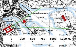
In theory, every part of a picture can be tied to a geographic location, but in the most typical application, only the position of the photographer is associated with the entire digital image. This has implications for search and retrieval. For example, photos of a mountain summit can be taken from different positions miles apart. To find all images of a particular summit in an image database, all photos taken within a reasonable distance must be considered. The point position of the photographer can in some cases include the bearing
Bearing (navigation)
In marine navigation, a bearing is the direction one object is from another object, usually, the direction of an object from one's own vessel. In aircraft navigation, a bearing is the actual compass direction of the forward course of the aircraft...
, the direction the camera was pointing.
Methods of geotagging photographs
There are a few methods of geotagging photographs, either automatic or manual. Automatic methods provide the easiest and most precise method of geotagging an image, providing that a good signal has been acquired at the time of taking the photo.Automatic using a built in GPS
Several manufacturers offer cameras with a built-in GPS receiver, but most cameras with this capability are camera phoneCamera phone
A camera phone is a mobile phone which is able to capture still photographs . Since early in the 21st century the majority of mobile phones in use are camera phones....
s as camera manufacturers after initial experience in the market came to treat GPS cameras as a niche market
Niche market
A niche market is the subset of the market on which a specific product is focusing; therefore the market niche defines the specific product features aimed at satisfying specific market needs, as well as the price range, production quality and the demographics that is intended to impact...
. The 2008 Nikon P6000, for example, an early geotagging camera, was replaced in 2010 by the P7000 which lacked that feature. Some models also include a compass to indicate the direction the camera was facing when the picture was taken.
- Panasonic Lumix DMC-TZ10Panasonic Lumix DMC-TZ10The Panasonic Lumix DMC-TZ10 is a compact 'Travel Zoom' digital camera with a 12x zoom lens and GPS receiver. The camera can be connected to a USB port and weighs 218 grams.In North America, the camera is referred to by model code DMC-ZS7....
- Sony Alpha 55Sony Alpha 55The Sony α55 is a midrange-level SLT camera, released in August 2010....
V (DSLR) - Sony DSC-HX5V
- Compact CameraPoint and shoot cameraA point-and-shoot camera, also called a compact camera, is a still camera designed primarily for simple operation. Most use focus free lenses or autofocus for focusing, automatic systems for setting the exposure options, and have flash units built in....
CasioCasiois a multinational electronic devices manufacturing company founded in 1946, with its headquarters in Shibuya, Tokyo, Japan. Casio is best known for its electronic products, such as calculators, audio equipment, PDAs, cameras, musical instruments, and watches...
EX-10HG is advertised as Hybrid-GPS. - Some mobile phones with assisted GPSAssisted GPSAssisted GPS, generally abbreviated as A-GPS or aGPS, is a system which can, under certain conditions, improve the startup performance, or time-to-first-fix of a GPS satellite-based positioning system. It is used extensively with GPS-capable cellular phones as its development was accelerated by...
use the cell phone network to speed GPS acquisition timeTime to first fixTime To First Fix is a measure of the time required for a GPS receiver to acquire satellite signals and navigation data, and calculate a position solution .-Scenarios:...
s.
Automatic using a connected GPS
Some digital camera
Digital camera
A digital camera is a camera that takes video or still photographs, or both, digitally by recording images via an electronic image sensor. It is the main device used in the field of digital photography...
s and camera phone
Camera phone
A camera phone is a mobile phone which is able to capture still photographs . Since early in the 21st century the majority of mobile phones in use are camera phones....
s support an external GPS
Global Positioning System
The Global Positioning System is a space-based global navigation satellite system that provides location and time information in all weather, anywhere on or near the Earth, where there is an unobstructed line of sight to four or more GPS satellites...
receiver connected by cable, or inserted into the memory card slot or flash shoe. The Samsung SH100 can connect using Wi-Fi
Wi-Fi
Wi-Fi or Wifi, is a mechanism for wirelessly connecting electronic devices. A device enabled with Wi-Fi, such as a personal computer, video game console, smartphone, or digital audio player, can connect to the Internet via a wireless network access point. An access point has a range of about 20...
to get position data from a GPS-enabled smartphone
Smartphone
A smartphone is a high-end mobile phone built on a mobile computing platform, with more advanced computing ability and connectivity than a contemporary feature phone. The first smartphones were devices that mainly combined the functions of a personal digital assistant and a mobile phone or camera...
. Generally the relevant GPS data is automatically stored in the photo's EXIF
Exchangeable image file format
Exchangeable image file format is a standard that specifies the formats for images, sound, and ancillary tags used by digital cameras , scanners and other systems handling image and sound files recorded by digital cameras...
information when the photo is taken. A connected GPS will generally remain switched on continuously, requiring power, and will then have location information available immediately when the camera is switched on.
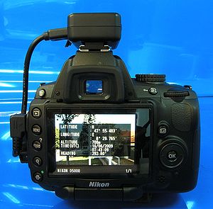
Many GPS-ready cameras are currently available, made by manufacturers such as Nikon
Nikon
, also known as just Nikon, is a multinational corporation headquartered in Tokyo, Japan, specializing in optics and imaging. Its products include cameras, binoculars, microscopes, measurement instruments, and the steppers used in the photolithography steps of semiconductor fabrication, of which...
, Fujifilm
Fujifilm
is a multinational photography and imaging company headquartered in Tokyo, Japan.Fujifilm's principal activities are the development, production, sale and servicing of color photographic film, digital cameras, photofinishing equipment, color paper, photofinishing chemicals, medical imaging...
, Sony
Sony
, commonly referred to as Sony, is a Japanese multinational conglomerate corporation headquartered in Minato, Tokyo, Japan and the world's fifth largest media conglomerate measured by revenues....
and Panasonic
Panasonic
Panasonic is an international brand name for Japanese electric products manufacturer Panasonic Corporation, which was formerly known as Matsushita Electric Industrial Co., Ltd...
. For complete lists go to the link list below.
Automatic geotagging combined with real-time transfer and publishing results in real-time geotagging.
Synchronizing with a separate GPS
Most cameras sold today do not contain a built-in GPS receiver; however, an external location-aware device, such as a hand-held GPS logger, can still be used with a non-GPS digital camera for geotagging. The photo is taken without geographical information and is processed later using software in conjunction with the GPS data. Timestamps made by the camera can be compared with timestamps in the recorded GPS information, provided that the clocks in the separate devices can be synchronized. The resulting coordinates can then be added to the EXIF information of the photo.Manual geotagging
Location information can also be added to photos, for example via its Exif specification that has fields for longitude/latitude, even if no GPS device was present when the photo was taken.The information can be entered by directly giving the coordinates or by selecting a location from a map using software tools. Some tools allow entry of tags such as city, postal code
Postal code
A postal code is a series of letters and/or digits appended to a postal address for the purpose of sorting mail. Once postal codes were introduced, other applications became possible.In February 2005, 117 of the 190 member countries of the Universal Postal Union had postal code systems...
or a street address. Geocoding
Geocoding
Geocoding is the process of finding associated geographic coordinates from other geographic data, such as street addresses, or zip codes...
and reverse geocoding
Reverse geocoding
Reverse geocoding is the process of back coding of a point location to a readable address or place name. This permits the identification of nearby street addresses, places, and/or areal subdivisions such as neighbourhoods, county, state, or country...
can be used to convert between locations and addresses.
Remote standoff capture
Some manufacturers of professional mapping-grade GPS instruments have integrated a GPS receiver with a laser rangefinder and digital cameraDigital camera
A digital camera is a camera that takes video or still photographs, or both, digitally by recording images via an electronic image sensor. It is the main device used in the field of digital photography...
. These multi-functional tools enable the capture of a remote geographical position (up to 3,300 feet/1,000 meters) and link the photograph to the subject's location, independent of the photographer’s position. These instruments are commonly used when the user is unable to reach and be on the target, the position is inaccessible (for example over a valley or wetland), there are personal health & safety concerns (motorway traffic), or the user wants to quickly capture multiple targets from a single, safe position (trees, street signage and furniture).
Integrated GPS cameras with rangefinders and remote standoff capability are currently available made by manufacturers such as Ricoh and Surveylab.
Uses
When geotagged photos are uploaded to online sharing communities such as FlickrFlickr
Flickr is an image hosting and video hosting website, web services suite, and online community that was created by Ludicorp in 2004 and acquired by Yahoo! in 2005. In addition to being a popular website for users to share and embed personal photographs, the service is widely used by bloggers to...
, Panoramio
Panoramio
Panoramio is a geolocation-oriented photo sharing website. Accepted photos uploaded to the site can be accessed as a layer in Google Earth and Google Maps, with new photos being added at the end of every month. The site's goal is to allow Google Earth users to learn more about a given area by...
or Moblog, the photo can be placed onto a map to view the location the photo was taken. In this way, users can browse photos from a map, search for photos from a given area, and find related photos of the same place from other users.
Many smartphone
Smartphone
A smartphone is a high-end mobile phone built on a mobile computing platform, with more advanced computing ability and connectivity than a contemporary feature phone. The first smartphones were devices that mainly combined the functions of a personal digital assistant and a mobile phone or camera...
s automatically geotag their photos by default. Photographers who prefer not to reveal their location can turn this feature off.
See also
- GeotaggingGeoTaggingGeotagging is the process of adding geographical identification metadata to various media such as a geotagged photograph or video, websites, SMS messages, QR Codes or RSS feeds and is a form of geospatial metadata...
- Point of InterestPoint of interestA point of interest, or POI, is a specific point location that someone may find useful or interesting. An example is a point on the Earth representing the location of the Space Needle, or a point on Mars representing the location of the mountain, Olympus Mons.The term is widely used in...
- GPS trackingGPS trackingA GPS tracking unit is a device that uses the Global Positioning System to determine the precise location of a vehicle, person, or other asset to which it is attached and to record the position of the asset at regular intervals...
- GeocodingGeocodingGeocoding is the process of finding associated geographic coordinates from other geographic data, such as street addresses, or zip codes...
- Geocoding on Commons