

GeoTagging
Encyclopedia
Metadata
The term metadata is an ambiguous term which is used for two fundamentally different concepts . Although the expression "data about data" is often used, it does not apply to both in the same way. Structural metadata, the design and specification of data structures, cannot be about data, because at...
to various media such as a geotagged photograph or video, websites, SMS messages, QR Codes or RSS
RSS (file format)
RSS is a family of web feed formats used to publish frequently updated works—such as blog entries, news headlines, audio, and video—in a standardized format...
feeds and is a form of geospatial metadata
Geospatial metadata
Geospatial metadata is a type of metadata that is applicable to objects that have an explicit or implicit geographic extent, in other words, are associated with some position on the surface of the Globe...
. These data usually consist of latitude and longitude coordinates
Geographic coordinate system
A geographic coordinate system is a coordinate system that enables every location on the Earth to be specified by a set of numbers. The coordinates are often chosen such that one of the numbers represent vertical position, and two or three of the numbers represent horizontal position...
, though they can also include altitude
Altitude
Altitude or height is defined based on the context in which it is used . As a general definition, altitude is a distance measurement, usually in the vertical or "up" direction, between a reference datum and a point or object. The reference datum also often varies according to the context...
, bearing
Bearing (navigation)
In marine navigation, a bearing is the direction one object is from another object, usually, the direction of an object from one's own vessel. In aircraft navigation, a bearing is the actual compass direction of the forward course of the aircraft...
, distance, accuracy data, and place names.
Geotagging can help users find a wide variety of location-specific information. For instance, one can find images taken near a given location by entering latitude and longitude coordinates into a suitable image search engine
Search engine
A search engine is an information retrieval system designed to help find information stored on a computer system. The search results are usually presented in a list and are commonly called hits. Search engines help to minimize the time required to find information and the amount of information...
. Geotagging-enabled information services can also potentially be used to find location-based news, websites, or other resources. Geotagging can tell users the location of the content of a given picture or other media or the point of view
Perspective (visual)
Perspective, in context of vision and visual perception, is the way in which objects appear to the eye based on their spatial attributes; or their dimensions and the position of the eye relative to the objects...
, and conversely on some media platforms show media relevant to a given location.
The related term geocoding
Geocoding
Geocoding is the process of finding associated geographic coordinates from other geographic data, such as street addresses, or zip codes...
refers to the process of taking non-coordinate based geographical identifiers, such as a street address, and finding associated geographic coordinates (or vice versa for reverse geocoding). Such techniques can be used together with geotagging to provide alternative search techniques.
Geotagging techniques
The base for geotagging is positions. The position will, in almost every case, be derived from the global positioning systemGlobal Positioning System
The Global Positioning System is a space-based global navigation satellite system that provides location and time information in all weather, anywhere on or near the Earth, where there is an unobstructed line of sight to four or more GPS satellites...
, and based on a latitude
Latitude
In geography, the latitude of a location on the Earth is the angular distance of that location south or north of the Equator. The latitude is an angle, and is usually measured in degrees . The equator has a latitude of 0°, the North pole has a latitude of 90° north , and the South pole has a...
/longitude
Longitude
Longitude is a geographic coordinate that specifies the east-west position of a point on the Earth's surface. It is an angular measurement, usually expressed in degrees, minutes and seconds, and denoted by the Greek letter lambda ....
-coordinate system that presents each location on the earth from 180° west through 180° east along the Equator
Equator
An equator is the intersection of a sphere's surface with the plane perpendicular to the sphere's axis of rotation and containing the sphere's center of mass....
and 90° north through 90° south along the prime meridian
Prime Meridian
The Prime Meridian is the meridian at which the longitude is defined to be 0°.The Prime Meridian and its opposite the 180th meridian , which the International Date Line generally follows, form a great circle that divides the Earth into the Eastern and Western Hemispheres.An international...
.
Geotagging photos
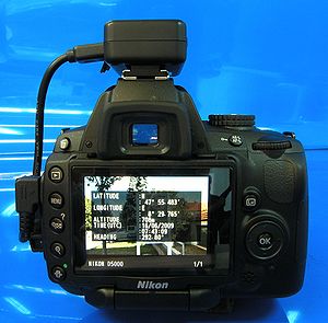
There are two main options for geotagging photos; capturing GPS information at the time the photo is taken or “attaching” the photograph to a map after the picture is taken.In order to capture GPS data at the time the photograph is captured, the user must have a camera with built in GPS or a standalone GPS along with a digital camera. Because of the requirement for wireless service providers in United States to supply more precise location information for 911 calls by September 11, 2012, more and more cell phones have built-in GPS chips. Most smart phones already utilize a GPS chip along with built-in cameras to allow users to automatically geotag photos. Others may have the GPS chip and camera but do not have internal software needed to embed the GPS information within the picture. A few digital cameras also have built-on or built-in GPS that allow for automatic geotagging.
Devices use GPS, A-GPS or both. A-GPS
Assisted GPS
Assisted GPS, generally abbreviated as A-GPS or aGPS, is a system which can, under certain conditions, improve the startup performance, or time-to-first-fix of a GPS satellite-based positioning system. It is used extensively with GPS-capable cellular phones as its development was accelerated by...
can be faster getting an initial fix if you are within range of a cell phone tower, and may work better inside buildings. Traditional GPS does not need cell phone towers and uses standard GPS signals outside of urban areas. Traditional GPS tends to use more battery power. Almost any digital camera can be coupled with a stand alone GPS and post processed with photo mapping software, to write the location information to the image's exif header. Examples include GPS-Photo Link, Alta4, EveryTrail, or EasyGPS.
GPS formats
GPS coordinates may be represented in text in a number of ways, with more or fewer decimalDecimal
The decimal numeral system has ten as its base. It is the numerical base most widely used by modern civilizations....
s:
| Template | Description | Example |
|---|---|---|
| [-]d.d, [-]d.d | Decimal degrees with negative numbers for South and West. | 12.3456, -98.7654 |
| {N>S}, d° m.m′ |
Degrees and decimal minutes with N, S, E or W suffix for North, South, East, West | 12° 20.736′ N, 98° 45.924′ W |
| {N>S} d° m.m′ |
Degrees and decimal minutes with N, S, E or W prefix for North, South, East, West | N 12° 20.736′, W 98° 45.924′ |
| {N>S}, d° m' s" |
Degrees, minutes and seconds with N, S, E or W suffix for North, South, East, West | 12° 20' 44" N, 98° 45' 55" W |
| {N>S} d° m' s", |
Degrees, minutes and seconds with N, S, E or W prefix for North, South, East, West | N 12° 20' 44", W 98° 45' 55" |
JPEG photos
With photos stored in JPEGJPEG
In computing, JPEG . The degree of compression can be adjusted, allowing a selectable tradeoff between storage size and image quality. JPEG typically achieves 10:1 compression with little perceptible loss in image quality....
file format, the geotag information is typically embedded in the metadata
Metadata
The term metadata is an ambiguous term which is used for two fundamentally different concepts . Although the expression "data about data" is often used, it does not apply to both in the same way. Structural metadata, the design and specification of data structures, cannot be about data, because at...
(stored in Exchangeable image file format
Exchangeable image file format
Exchangeable image file format is a standard that specifies the formats for images, sound, and ancillary tags used by digital cameras , scanners and other systems handling image and sound files recorded by digital cameras...
(EXIF) or Extensible Metadata Platform
Extensible Metadata Platform
The Adobe Extensible Metadata Platform is a standard, created by Adobe Systems Inc., for processing and storing standardized and proprietary information relating to the contents of a file....
(XMP) format). These data are not visible in the picture itself but are read and written by special programs and most digital camera
Digital camera
A digital camera is a camera that takes video or still photographs, or both, digitally by recording images via an electronic image sensor. It is the main device used in the field of digital photography...
s and modern scanners
Image scanner
In computing, an image scanner—often abbreviated to just scanner—is a device that optically scans images, printed text, handwriting, or an object, and converts it to a digital image. Common examples found in offices are variations of the desktop scanner where the document is placed on a glass...
. Latitude and longitude are stored in units of degrees with decimals. This geotag information can be read by many programs, such as the cross-platform
Cross-platform
In computing, cross-platform, or multi-platform, is an attribute conferred to computer software or computing methods and concepts that are implemented and inter-operate on multiple computer platforms...
open source
Open source
The term open source describes practices in production and development that promote access to the end product's source materials. Some consider open source a philosophy, others consider it a pragmatic methodology...
ExifTool
ExifTool
ExifTool is a free software program for reading, writing, and manipulating image, audio, and video metadata. It is platform independent, available as both a Perl library and command-line application...
. An example readout for a photo might look like:
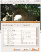
GPS Latitude : 57 deg 38' 56.83" NGPS Longitude : 10 deg 24' 26.79" EGPS Position : 57 deg 38' 56.83" N, 10 deg 24' 26.79" Eor the same coordinates could also be presented as decimal degrees:
GPSLatitude : 57.64911GPSLongitude : 10.40744GPSPosition : 57.64911 10.40744When stored in EXIF, the coordinates are represented as a series of rational numbers in the GPS sub-IFD. Here is a hexadecimal dump of the relevant section of the EXIF metadata (with big-endian
Endianness
In computing, the term endian or endianness refers to the ordering of individually addressable sub-components within the representation of a larger data item as stored in external memory . Each sub-component in the representation has a unique degree of significance, like the place value of digits...
byte order):
+ [GPS directory with 5 entries]| 0) GPSVersionID = 2 2 0 0| - Tag 0x0000 (4 bytes, int8u[4]):| dump: 02 02 00 00| 1) GPSLatitudeRef = N| - Tag 0x0001 (2 bytes, string[2]):| dump: 4e 00 [ASCII "N\0"]| 2) GPSLatitude = 57 38 56.83 (57/1 38/1 5683/100)| - Tag 0x0002 (24 bytes, rational64u[3]):| dump: 00 00 00 39 00 00 00 01 00 00 00 26 00 00 00 01| dump: 00 00 16 33 00 00 00 64| 3) GPSLongitudeRef = W| - Tag 0x0003 (2 bytes, string[2]):| dump: 57 00 [ASCII "W\0"]| 4) GPSLongitude = 10 24 26.79 (10/1 24/1 2679/100)| - Tag 0x0004 (24 bytes, rational64u[3]):| dump: 00 00 00 0a 00 00 00 01 00 00 00 18 00 00 00 01| dump: 00 00 0a 77 00 00 00 64SMS messages
The GeoSMSGeoSMS
GeoSMS is a specification for geotagging SMS messages.It works by embedding locations in the message text, where the locations are formatted as 'geo' URIs as defined in RFC 5870....
standard works by embedding one or more 'geo' URI
Geo URI
A geo' URI is a URI scheme defined by the Internet Engineering Task Force's RFC 5870 as:a Uniform Resource Identifier for geographic locations using the 'geo' scheme name...
s in the body of an SMS, for example:
I'm at the pub geo:-37.801631,144.980294;u=16
DNS entries
RFC 1876 defines a means for expressing location information in the Domain Name SystemDomain name system
The Domain Name System is a hierarchical distributed naming system for computers, services, or any resource connected to the Internet or a private network. It associates various information with domain names assigned to each of the participating entities...
. LOC resources records can specify the latitude, longitude, altitude, precision of the location, and the physical size of on entity attached to an IP address. However, in practice not all IP addresses have such a record, so it is more common to use geolocation
Geolocation
Geolocation is the identification of the real-world geographic location of an object, such as a radar, mobile phone or an Internet-connected computer terminal...
services to find the physical location of an IP address.
ICBM method
The GeoURL standard requires the ICBMICBM address
ICBM address or missile address is hacker slang for one's longitude and latitude when placed in a signature or another publicly available file.- Origin :...
tag method which is used to geotag standard web pages in HTML
HTML
HyperText Markup Language is the predominant markup language for web pages. HTML elements are the basic building-blocks of webpages....
format:
The similar Geo Tag format allows the addition of placename and region tags:
RDF feeds
The RDFResource Description Framework
The Resource Description Framework is a family of World Wide Web Consortium specifications originally designed as a metadata data model...
method is defined by W3 Group and presents the information in RDF tags:
        xmlns:geo="http://www.w3.org/2003/01/geo/wgs84_pos#">


    55.701

    12.552
Microformat
The Geo microformatGeo (microformat)
Geo is a microformat used for marking up WGS84 geographical coordinates in HTML. Although termed a "draft" specification, this is a formality, and the format is stable and in widespread use; not least as a sub-set of the published hCalendar and hCard microformat specifications, neither of which is...
allows coordinates within HTML pages to be marked up in such a way that they can be "discovered" by software tools. Example:
50.167958 -97.133185 which might display as:
50.167958; -97.133185
(giving a live Geo microformat
Microformat
A microformat is a web-based approach to semantic markup which seeks to re-use existing HTML/XHTML tags to convey metadata and other attributes in web pages and other contexts that support HTML, such as RSS...
on this page).
A proposal has been developed to extend Geo to cover other bodies, such as Mars
Mars
Mars is the fourth planet from the Sun in the Solar System. The planet is named after the Roman god of war, Mars. It is often described as the "Red Planet", as the iron oxide prevalent on its surface gives it a reddish appearance...
and the Moon
Moon
The Moon is Earth's only known natural satellite,There are a number of near-Earth asteroids including 3753 Cruithne that are co-orbital with Earth: their orbits bring them close to Earth for periods of time but then alter in the long term . These are quasi-satellites and not true moons. For more...
.
An example is the Flickr
Flickr
Flickr is an image hosting and video hosting website, web services suite, and online community that was created by Ludicorp in 2004 and acquired by Yahoo! in 2005. In addition to being a popular website for users to share and embed personal photographs, the service is widely used by bloggers to...
photo-sharing Web site, which provides geographic data for any geotagged photo in all of the above-mentioned formats.
Wikipedia
On WikipediaWikipedia
Wikipedia is a free, web-based, collaborative, multilingual encyclopedia project supported by the non-profit Wikimedia Foundation. Its 20 million articles have been written collaboratively by volunteers around the world. Almost all of its articles can be edited by anyone with access to the site,...
it is possible to include geotagged information in articles (and thus also images), using the template , while on Wikimedia Commons
Wikimedia Commons
Wikimedia Commons is an online repository of free-use images, sound and other media files. It is a project of the Wikimedia Foundation....
the template is often used to tag camera locations. The inserted coordinates will be presented in the top right corner as a link on the Wikimedia Toolserver, allowing the user to click further on to different geographic content on the Internet
Internet
The Internet is a global system of interconnected computer networks that use the standard Internet protocol suite to serve billions of users worldwide...
. For the article Råbjerg Mile
Råbjerg Mile
Råbjerg Mile is a migrating coastal dune between Skagen and Frederikshavn, Denmark. It is the largest moving dune in Northern Europe with an area of around 1 km² and a height of 40 m . The dune contains a total of 4 million m³ of sand.The wind moves it in a north-easterly direction up to...
it looks like this:
Geotagging in tag-based systems
No industry standards exist, however there are a variety of techniques for adding geographical identification metadata to an information resource. One convention, established by the website Geobloggers and used by more and more sites, e.g. photo sharing sites PanoramioPanoramio
Panoramio is a geolocation-oriented photo sharing website. Accepted photos uploaded to the site can be accessed as a layer in Google Earth and Google Maps, with new photos being added at the end of every month. The site's goal is to allow Google Earth users to learn more about a given area by...
and Flickr
Flickr
Flickr is an image hosting and video hosting website, web services suite, and online community that was created by Ludicorp in 2004 and acquired by Yahoo! in 2005. In addition to being a popular website for users to share and embed personal photographs, the service is widely used by bloggers to...
, and the social bookmarking site del.icio.us
Del.icio.us
Delicious is a social bookmarking web service for storing, sharing, and discovering web bookmarks. The site was founded by Joshua Schachter in 2003 and acquired by Yahoo! in 2005, and by the end of 2008, the service claimed more than 5.3 million users and 180 million unique bookmarked URLs...
, enables content to be found via a location search. All sites allow users to add metadata to an information resource via a set of so-called machine tags (see folksonomy
Folksonomy
A folksonomy is a system of classification derived from the practice and method of collaboratively creating and managing tags to annotate and categorize content; this practice is also known as collaborative tagging, social classification, social indexing, and social tagging...
).
geotaggedgeo:lat=57.64911geo:lon=10.40744This describes the geographic coordinates of a particular location in terms of latitude
Latitude
In geography, the latitude of a location on the Earth is the angular distance of that location south or north of the Equator. The latitude is an angle, and is usually measured in degrees . The equator has a latitude of 0°, the North pole has a latitude of 90° north , and the South pole has a...
(geo:lat) and longitude
Longitude
Longitude is a geographic coordinate that specifies the east-west position of a point on the Earth's surface. It is an angular measurement, usually expressed in degrees, minutes and seconds, and denoted by the Greek letter lambda ....
(geo:lon). These are expressed in decimal degrees in the WGS84 datum, which has become something of a default geodetic datum with the advent of GPS.
Using three tags works within the constraint of having tags that can only be single 'words'. Identifying geotagged information resources on sites like Flickr
Flickr
Flickr is an image hosting and video hosting website, web services suite, and online community that was created by Ludicorp in 2004 and acquired by Yahoo! in 2005. In addition to being a popular website for users to share and embed personal photographs, the service is widely used by bloggers to...
and del.icio.us
Del.icio.us
Delicious is a social bookmarking web service for storing, sharing, and discovering web bookmarks. The site was founded by Joshua Schachter in 2003 and acquired by Yahoo! in 2005, and by the end of 2008, the service claimed more than 5.3 million users and 180 million unique bookmarked URLs...
is done by searching for the 'geotagged' tag, since the tags beginning 'geo:lat=' and 'geo:lon=' are necessarily very variable.
Another option is to tag with a Geohash
Geohash
Geohash is a latitude/longitude geocode system inventedby Gustavo Niemeyer when writing the web service at geohash.org, andput into the public domain...
:
geo:hash=u4pruydqqvjA further convention proposed by FlickrFly adds tags to specify the suggested viewing angle and range when the geotagged location is viewed in Google Earth
Google Earth
Google Earth is a virtual globe, map and geographical information program that was originally called EarthViewer 3D, and was created by Keyhole, Inc, a Central Intelligence Agency funded company acquired by Google in 2004 . It maps the Earth by the superimposition of images obtained from satellite...
:
ge:head=225.00ge:tilt=45.00ge:range=560.00These three tags would indicate that the camera is pointed heading 225° (south west), has a 45° tilt and is 560 metres from the subject.
Where the above methods are in use, their coordinates may differ from those specified by the photo's internal EXIF data, for example because of a correction or a difference between the camera's location and the subject's.
Geoblogging
Geoblogging attaches specific geographic location information to blogBlog
A blog is a type of website or part of a website supposed to be updated with new content from time to time. Blogs are usually maintained by an individual with regular entries of commentary, descriptions of events, or other material such as graphics or video. Entries are commonly displayed in...
entries via geotags. Searching a list of blogs and pictures tagged using geotag technology allows users to select areas of specific interest to them on interactive maps.
The progression of GPS technology, along with the development of various online applications, has fueled the popularity of such tagged blogging, and the combination of GPS Phones and GSM localization, has led to the moblogging, where blog posts are tagged with exact position of the user. Real-time geotagging relays automatically geotagged media such as photos or video to be published and shared immediately.
Wikipedia article geosearching apps
One of the first attempts to initiate the geotagging aspect of searching and locating articles seems to be the now-inoperative site Wikinear.com, launched in 2008, which showed the user Wikipedia pages that are geographically closest to one's current location.The 2009 app Cyclopedia works relatively well showing geotagged Wikipedia articles located within several miles of ones location, integrated with a street-view mode, and 360-degree mode.
The app Respotter Wiki, launched in 2009, claims to feature Wikipedia searching via a map, also allowing users to interact with people around them, via messaging and reviews, etc. The app, in its current function, however, seems to give only geotagged photo results.
Dangers of geotagging
Following a scientific study and several demonstrative websites, a discussion on the privacy implications of geotagging has raised public attention. In particular, the automatic embedding of geotags in pictures taken with smartphones is often ignored by cell-phone users. As a result, people are often not aware that the photos they publish on the Internet have been geotagged. Many celebrities reportedly gave away their home location without knowing it. According to the study, a significant number of for-sale advertisements on CraigslistCraigslist
Craigslist is a centralized network of online communities featuring free online classified advertisements, with sections devoted to jobs, housing, personals, for sale, services, community, gigs, résumés, and discussion forums....
, that were otherwise anonymized, contained geotags, thereby revealing the location of high-valued goods—sometimes in combination with clear hints to the absence of the offerer at certain times. Publishing photos and other media tagged with exact geolocation on the Internet allows random people to track an individual's location and correlate it with other information. Therefore, criminals could find out when homes are empty because their inhabitants posted geotagged and timestamped information both about their home address and their vacation residence. These dangers can be avoided by removing geotags with a metadata removal tool
Metadata removal tool
Metadata removal tool or Metadata scrubber is a type of privacy software built to protect the privacy of its users by removing potentially privacy-compromising metadata from files before they are shared with others Metadata removal tool or Metadata scrubber is a type of privacy software built to...
for photos before publishing them on the Internet.
See also
- Geotagged photograph
- GeocachingGeocachingGeocaching is an outdoor sporting activity in which the participants use a Global Positioning System receiver or mobile device and other navigational techniques to hide and seek containers, called "geocaches" or "caches", anywhere in the world....
- Geographic information systemGeographic Information SystemA geographic information system, geographical information science, or geospatial information studies is a system designed to capture, store, manipulate, analyze, manage, and present all types of geographically referenced data...
(GIS) - GeoreferenceGeoreferenceTo georeference something means to define its existence in physical space. That is, establishing its location in terms of map projections or coordinate systems. The term is used both when establishing the relation between raster or vector images and coordinates, and when determining the spatial...
- GeoRSSGeoRSSGeoRSS is an emerging standard for encoding location as part of a Web feed. GeoRSS is an emerging standard for encoding location as part of a Web feed. GeoRSS is an emerging standard for encoding location as part of a Web feed. (Web feeds are used to describe feeds ("channels") of content, such as...
- SupranetSupranetSupranet is a term coined at the turn of the 21st century by information technology analysis firm Gartner to describe the fusion of the physical and the digital worlds.-History:...
- TaggingTag (metadata)In online computer systems terminology, a tag is a non-hierarchical keyword or term assigned to a piece of information . This kind of metadata helps describe an item and allows it to be found again by browsing or searching...