

Future Developments in Singapore
Encyclopedia
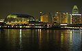
This article shows the main future developments in the city of Singapore
. Most developments are found in the New Downtown, the Marina Bay.
, is a multi-phase development located along Marina Boulevard at Marina Bay, Singapore. It will be the largest office development to date in the city in terms of gross floor area when fully completed. Tower 1, 2 and Marina Bay Residences was completed in 2010 while Tower 3 and Marina Bay Suites is expected to be complete in 2013.
, located in Marina Bay, is a twin-tower mixed-use development that comprises 2000000 square feet (185,806.1 m²) of grade A office space, a 280-room five-star hotel, 60000 square feet (5,574.2 m²) of retail space and 'The Cube', a 100000 square feet (9,290.3 m²) open public space used for networking or relaxing with a regular programme of exhibitions and performances. Tower 1 will be completed by 2011 while Tower 2 will be completed by 2013.
is a planned commercial and residential complex to be located on Beach Road in the Downtown Core
of Singapore
. The new development will comprise offices, two hotels, shops and residences. The complex is scheduled for completion in 2016.
. The site features a 20,000 spectators grandstand
, a 4 km grade 2 race track, a 1.2 km karting track and lifestyle attractions like food and beverage outlets, a beach front and a museum. It is originally expected to be ready in end-2011. However, construction stopped in January 2011 due to outstanding payment from SG Changi to contractor CSC Holdings who is contracted for piling works. New investors were brought on board and a revised timeline were submitted to Singapore Sports Council
. The revised timeline will see the facility to be up by 2014.
at Kallang
will replace the National Stadium of Singapore. The expected year of completion was 2011 but later delayed till 2014. On 19 January 2008, it was announced that the Singapore Sports Hub consortium would develop the Sports Hub.
announced on 4 April 2008 the blueprint for Jurong Lake District
. The vision for Jurong Lake District is to transform it into a 360 hectare unique lakeside destination for business and leisure in the next 10 to 15 years. It will be the largest commercial hub outside the city.
, is situated beside the Singapore Zoo
and Night Safari
, in Mandai
. The park will feature more than 300 plant species and 500 animal species. River Safari will also be home to the Giant Panda
s from China when they arrive by the third quarter of 2011 as part of a joint collaboration with the China Wildlife Conservation Association. The park is expected to be ready by first half of 2012.
, which is already under construction, will be Singapore's fourth Mass Rapid Transit
line. It will open in five phases and is set to be fully operational in 2012. The third phase (CC12 to CC16) has commenced operations on 28 May 2009. It is expected to reduce travel time for those not going to the city center and to reduce congestion by allowing passengers to bypass the crowded central area stations. The first and second phases (CC1 to CC11) are now also in operation, while the fourth and fifth phases (CC17 to CC29) are to open in the fourth quarter of 2011. The extension from Promenade station to Bayfront and Marina Bay stations is expected to open in 2012.
Originally projected to cost $6.7 billion, the budget has been increased a number of times due to increases in the price of sand, gravel, and concrete. The line will be 33.3 km in length and service 29 stations. It will start from the Dhoby Ghaut MRT Station
and end at the HarbourFront MRT Station
, interchanging at Paya Lebar MRT Station
, Serangoon MRT Station
, Bishan MRT Station
and Buona Vista MRT Station
.
is a future 33-station Mass Rapid Transit
line, with 11 stations linked to the existing MRT network. It is estimated to cost $1.4 billion, and is slated for construction once the Circle Line is complete. It is expected to be fully completed by 2017. It will connect the north-west and east of the island to the central business district and Marina Bay. Its schematic profile, station names as well as alpha-numeric and end-destination codes are subject to confirmation.
Most of the stations will be underground to optimise land use and minimise land acquisition. When completed, the DTL will add 40 km to the current network's 109 km of track as well as the upcoming Circle Line's 37 km. The Land Transport Authority claims the DTL will enhance accessibility to the new downtown, cut travel time and improve connectivity on the existing MRT network.
The first stage will feature 6 stations, connecting Bugis MRT Station
to Chinatown MRT Station
via Marina South
, interchanging at Promenade MRT Station
. It will mainly serve people who are going to the Marina Bay Financial Centre
and Marina Bay Sands.
The second stage will feature 12 stations, connecting Bukit Panjang
to the Downtown area via Bukit Timah
, interchanging at Little India MRT Station
, Newton MRT Station
and Botanic Gardens MRT Station
. It will mainly serve people going Downtown from the western part of Singapore. It will also reduce traffic jams along Bukit Timah Road
.
The third stage will feature 15 stations, connecting eastern areas of Singapore such as Tampines
, Bedok Reservoir
and MacPherson to the Downtown area, interchanging at MacPherson MRT Station
, Tampines MRT Station
and Expo MRT Station
. The complete line should be completed by late 2017.
is a 21 hectare MRT depot located in the Kwong Hou Sua Teochew Cemetery off Woodlands Road. Therefore, many graves in the cemetery have to be exhumed. Exhumation of graves started in December 2008 and construction will start in the first quarter of 2009. It is slated for completion by 2015 to serve the Downtown MRT Line
.
were revived, this time consisting only of the southern half of what was a continuous loop involving Stage 3 of the Downtown Line. The new 21-kilometre route will have 12 stations, commencing from Marina South
and onwards to Marina East
, Tanjong Rhu
, Siglap
, Marine Parade
and Bedok
South, terminating further north at Changi
. The underground line is expected to be completed by 2020. This will increase accessibility to the East Coast areas, where there is currently no direct MRT link.
which will extend from the western end of the Eastern Region MRT Line and link it to the northern part of Singapore. En-route, the 27-kilometre line will connect from Marina South
through the Central Business District and up through Ang Mo Kio
all the way to Woodlands
connecting estates such as Sin Ming
, Kebun Baru
, Thomson
and Kim Seng
which do not now have a direct MRT link. Completion of the 18-station line, also fully underground, is expected in 2018.
into Tuas
, involving the building of another five stations. The latest extension is slated for completion by 2016, with provisions made for a future branch line into Tuas South.
The Tuas Extension will be fully elevated.
will be extended by a kilometre southwards beyond Marina Bay MRT Station
to serve the Marina Bay
area, such as the new International Cruise Terminal
which is currently under construction. The extension will involve one new station planned for completion by 2014.
The Marina Bay Extension will be fully underground.
, and will link the area to the eastern and western parts of Singapore. It is stated for completion by end 2013. It will connect Kallang–Paya Lebar Expressway and Ayer Rajah Expressway
, passing through Marina South
and Marina East.
and Sembawang
to the western end of the East Coast Parkway
, relieving traffic on the congested Central Expressway
. It is slated for completion by 2020.
. The details for the construction is that it might have to be extended out onto Changi East where there is now a big empty plot of land. There may be also plans to build another runway. 3
area, near the existing Marina South Pier
. Following complaints from international cruise line companies about poor facilities at the Singapore Cruise Centre
, the new terminal will be large enough to accommodate the largest cruise ships in the world and is believed to help position Singapore as the homeport for many Asian cruise companies. It will double the present number of cruise berths. Work is scheduled to begin in June 2008 and is slated for completion by 2010.
On 18 March 2009, authorities have revealed the International Cruise Terminal's design. The roof of the terminal will depict a modern interpretation of low rolling waves. This will provide a welcoming sight to passengers as they arrive in Singapore by cruise. This will also add to the distinctive Downtown skyline that includes the Marina Bay Sands, the Singapore Flyer
and more. Groundbreaking is expected to take place in the second quarter, and the whole terminal is slated for completion by end 2011.
Singapore Cruise Center and SATS, in a joint partnership with European cruise terminal operator Creuers Del Port de Barcelona SA, had submitted tenders to manage and operate the International Cruise Terminal.
into a residential new town. Currently, the southern parts of Punggol
are developed, mostly with HDB flats. There are ongoing projects to build a town centre, supposedly with an air-conditioned bus interchange. There is going to be a man-made canal dug through Punggol, connecting the future Serangoon Reservoir and Punggol Reservoir. Many developments are proposed to be built along the canal, such as shopping centers and many more HDB flats. There will be recreation clubs, community centers, sports clubs, polyclinics and many others, attracting many people to live and visit Punggol
. There are plans to develop Punggol Point
, which currently only has a beach. It will propose to have a seafood restaurant and maybe more HDB flats in the near vicinity. More parking lots are under construction, and this will attract many people to the presently remote beach. The northwest of Punggol
will be developed and the West Loop of the Punggol LRT Line
will be in operation, serving the area.
is an ongoing project that includes the building of three major parks at Marina Centre
, Marina South
and Marina East
, mostly on the coastal areas of Marina Bay. Groundbreaking started in November 2007, and the first phase of the Marina South Gardens is slated for completion by end 2010. It surrounds the coasts of Marina Bay, and they are linked by bridges built over the bay and rivers, such as the Marina Barrage
and The Helix Bridge mentioned above. It will take up 94 hectares of land altogether, with 54 hectares in Marina South
, 30 hectares at Marina East
and 10 hectares at Marina Centre
.
at Marina South
is designed by UK-based design firm Grant Associates. It will be the future permanent home of the Singapore Garden Festival
. It is linked to the Gardens at Marina Centre by The Helix Bridge and the Gardens at Marina East by the Marina Barrage
. There are a few main attractions at the Marina Bay Gardens:
Firstly, there are the SuperTrees. They are tree-like structures which height range from 25 to 50 metres. They are vertical gardens and will provide shade and shelter, which is especially important for a tropical country like Singapore. They will also be embedded with sustainable energy and water technologies, like collecting rainwater on the roof, which are integral to the cooling of the Cool Conservatories. At night, these SuperTrees will come alive with lighting and projected media. People might even be able to eat and drink on the roof of the SuperTrees.
Secondly, the Cool Conservatories is an architectural icon that houses many varieties of plants and trees. It showcases sustainable energy technology too. Since it is located in an enclosed space, visitors do not have to worry about the weather. It will provide an “edutainment” space within the Gardens, a combination of education and entertainment, where people can rest and relax and also learn more about plant biology. It will consist of a “Cool Moist” Conservatory taking up 0.9 hectares and a “Cool Dry” Conservatory taking up 1.4 hectares of space, and will display plants and flowers from the Tropical Montane and Mediterranean environments.
Thirdly, the Horticultural Show Gardens, taking up 2.6 hectares of land, will showcase the best of tropical horticulture and garden artistry. It will be made up of 'Lion Grove', consisting of a cluster of SuperTrees, 'The Orchidetum', a luxurious garden showcasing orchids, 'Pride of Singapore', a cluster of beautiful gardens and flower displays representing the very best of Singaporean horticulture and 'Global Garden Display', a mix of both permanent and temporary themed gardens in and around the entrance plaza to the main buildings that represents global awareness of horticulture and plant conservation.
Fourthly, the Plant Edutainment Gardens, taking up 2.5 hectares, is a combination of education and entertainment, and will focus on the theme of “Plant use by Man”. They will provide an interactive display of the 'economic plants' that have contributed to the development of Singapore and Southeast Asia for education.
Also, there will be a Flower Market, taking up 2.8 hectares of land, which will eventually be the main entry precinct into the Gardens. It will consist of an indoor events space, retail and various food and beverage outlets.
Lastly, the Main Events Space will be a 2 hectare event lawn with a stage. It can host up to 7,000 people during international and national events.
at Marina East
is designed by UK-based design firm Gustafson Porter. It will be a waterfront park that is connected to East Coast Park
. This watersports themed park will allow for activities such as canoeing, water skiing, sculling and dragon boat races to be conducted along the Channel. It will also feature a number of artificial waterfalls and a wading pool. It is linked to the Gardens at Marina South by the Marina Barrage
.
at Marina Centre
will have a waterfront promenade called Marina Promenade stretching 2.8 km. It houses the Singapore Flyer
, The Float at Marina Bay and Esplanade - Theatres on the Bay
. It is linked to the Gardens at Marina by the Double Helix Bridge
.
, Seafront living at Woodlands, Youth Olympic Games Village, Jurong General Hospital, Nex
, Jurong Entertainment Centre
and Singapore University of Technology and Design
.
Singapore
Singapore , officially the Republic of Singapore, is a Southeast Asian city-state off the southern tip of the Malay Peninsula, north of the equator. An island country made up of 63 islands, it is separated from Malaysia by the Straits of Johor to its north and from Indonesia's Riau Islands by the...
. Most developments are found in the New Downtown, the Marina Bay.
One Raffles Place (Tower 2)
One Raffles Place (Tower 2) will be constructed on the site of the previous OUB Centre, and once completed (alongside the existing OUB Centre), the entire complex will be renamed One Raffles Place. The new tower will be 38 storeys tall with a height of 205m. The design is dominated by a triangular pattern on the façade that give it a prism-like effect, tricking the eye into thinking it is a less regularly shaped building. This is emphasised by the way the outer façade touches the ground at an acute point and the way the top section of the skyscraper leans towards the OUB Center. The tower was designed by Tange Associates and SAA Architects and completion of One Raffles Place (Tower 2) is expected in Q2 2011.Marina Bay Financial Centre
The Marina Bay Financial CentreMarina Bay Financial Centre
The Marina Bay Financial Centre , located along Marina Boulevard at Marina Bay, Singapore stands on a 3.55 hectare site, consisting of three office towers, two residential towers and retail space at Marina Bay Link Mall....
, is a multi-phase development located along Marina Boulevard at Marina Bay, Singapore. It will be the largest office development to date in the city in terms of gross floor area when fully completed. Tower 1, 2 and Marina Bay Residences was completed in 2010 while Tower 3 and Marina Bay Suites is expected to be complete in 2013.
Asia Square
Asia SquareAsia Square
Asia Square , located along Marina View at Marina Bay in Singapore, is a twin-tower mixed-use development that will comprise of grade A office space, a 280-room five-star hotel, of retail space and 'The Cube', a open public space used for networking or relaxing with a regular programme of...
, located in Marina Bay, is a twin-tower mixed-use development that comprises 2000000 square feet (185,806.1 m²) of grade A office space, a 280-room five-star hotel, 60000 square feet (5,574.2 m²) of retail space and 'The Cube', a 100000 square feet (9,290.3 m²) open public space used for networking or relaxing with a regular programme of exhibitions and performances. Tower 1 will be completed by 2011 while Tower 2 will be completed by 2013.
South Beach
South BeachSouth Beach, Singapore
South Beach is a planned commercial and residential complex to be located on Beach Road in the Downtown Core of Singapore. The new development will comprise offices, two hotels, shops and residences. The project includes the restoration of four conservation buildings — the former...
is a planned commercial and residential complex to be located on Beach Road in the Downtown Core
Downtown Core
The Downtown Core is a 266-hectare urban planning area in the south of the city-state of Singapore. The Downtown Core surrounds the mouth of the Singapore River and southeastern portion of its watershed, and is part of the Central Area, Singapore's central business district...
of Singapore
Singapore
Singapore , officially the Republic of Singapore, is a Southeast Asian city-state off the southern tip of the Malay Peninsula, north of the equator. An island country made up of 63 islands, it is separated from Malaysia by the Straits of Johor to its north and from Indonesia's Riau Islands by the...
. The new development will comprise offices, two hotels, shops and residences. The complex is scheduled for completion in 2016.
Changi Motorsports Hub
The Changi Motorsports Hub houses the Singapore's first permanent racing track. It is situated next to the Changi Exhibition CentreChangi Exhibition Centre
The Changi International Exhibition and Convention Centre , formerly also commonly referred to simply as the Changi Exhibition Centre, is a convention center in Singapore located just beyond the northern edge perimeter fencing of Singapore Changi Airport, and had served as the venue for the Asian...
. The site features a 20,000 spectators grandstand
Grandstand
A grandstand is a large and normally permanent structure for seating spectators, most often at a racetrack. This includes both auto racing and horse racing. The grandstand is in essence like a single section of a stadium, but differs from a stadium in that it does not wrap all or most of the way...
, a 4 km grade 2 race track, a 1.2 km karting track and lifestyle attractions like food and beverage outlets, a beach front and a museum. It is originally expected to be ready in end-2011. However, construction stopped in January 2011 due to outstanding payment from SG Changi to contractor CSC Holdings who is contracted for piling works. New investors were brought on board and a revised timeline were submitted to Singapore Sports Council
Singapore Sports Council
The Singapore Sports Council is a statutory board under the Ministry of Community Development, Youth and Sports of the Singapore Government...
. The revised timeline will see the facility to be up by 2014.
Sports Hub
The Singapore Sports HubSingapore Sports Hub
The Singapore Sports Hub is a proposed sports complex located in Kallang, Singapore to be built on the present site of the National Stadium, which was officially closed on 30 June 2007 and demolition started on 29 September 2010...
at Kallang
Kallang
Kallang is an urban planning area and a subdivision located in the southeastern part of Singapore.It is probably best known for being the location of the Singapore Indoor Stadium & the old National Stadium, as well as the new Singapore Sports Hub...
will replace the National Stadium of Singapore. The expected year of completion was 2011 but later delayed till 2014. On 19 January 2008, it was announced that the Singapore Sports Hub consortium would develop the Sports Hub.
Jurong Lake District
The Urban Redevelopment AuthorityUrban Redevelopment Authority
The Urban Redevelopment Authority is the national urban planning authority of Singapore, and a statutory board under the Ministry of National Development of the Singapore Government.-Mission:The authority was established on 1 April 1974, and is of especially critical importance to the city-state,...
announced on 4 April 2008 the blueprint for Jurong Lake District
Jurong Lake District
Jurong Lake District is a district of Singapore. It consists of two zones, namely Jurong Gateway and Lakeside. It is 360 hectares in size and served by two major expressways and three MRT stations.-Remaking Our Heartland:...
. The vision for Jurong Lake District is to transform it into a 360 hectare unique lakeside destination for business and leisure in the next 10 to 15 years. It will be the largest commercial hub outside the city.
River Safari
Asia's first river-themed park, River SafariRiver Safari
The River Safari is an upcoming river-themed zoo located in Singapore to be opened in 2012 with construction set to be completed in late 2011. The attraction built over 12 hectares of land, and will be nestled between its two counterparts the Singapore Zoo and the Night Safari...
, is situated beside the Singapore Zoo
Singapore Zoo
The Singapore Zoo , formerly known as the Singapore Zoological Gardens and commonly known locally as the Mandai Zoo, occupies 28 hectares of land on the margins of Upper Seletar Reservoir within Singapore's heavily forested central catchment area. The zoo was built at a cost of S$9m granted by...
and Night Safari
Night Safari
The Night Safari is the world's first nocturnal zoo and is one of the most popular tourist attractions in Singapore.The concept of a nocturnal park in Singapore was mooted in the 1980s by the former executive chairman of the Singapore Zoo, Dr Ong Swee Law...
, in Mandai
Mandai
Mandai is the name of an urban planning area located in the North Region of Singapore. Mandai Road passes through the area, linking Woodlands Road to Upper Thomson Road....
. The park will feature more than 300 plant species and 500 animal species. River Safari will also be home to the Giant Panda
Giant Panda
The giant panda, or panda is a bear native to central-western and south western China. It is easily recognized by its large, distinctive black patches around the eyes, over the ears, and across its round body. Though it belongs to the order Carnivora, the panda's diet is 99% bamboo...
s from China when they arrive by the third quarter of 2011 as part of a joint collaboration with the China Wildlife Conservation Association. The park is expected to be ready by first half of 2012.
Circle MRT Line (CCL)
The Circle MRT LineCircle MRT Line
The Circle Line is Singapore's fourth Mass Rapid Transit line, operated by SMRT Corporation. This underground line is currently long with 28 stations and is fully automatically operated...
, which is already under construction, will be Singapore's fourth Mass Rapid Transit
Mass Rapid Transit
The term Mass Rapid Transit may refer to Rapid transit.The name Mass Rapid Transit is used by the following specific rapid transit systems, either as an official name or otherwise:* Mass Rapid Transit system in Singapore...
line. It will open in five phases and is set to be fully operational in 2012. The third phase (CC12 to CC16) has commenced operations on 28 May 2009. It is expected to reduce travel time for those not going to the city center and to reduce congestion by allowing passengers to bypass the crowded central area stations. The first and second phases (CC1 to CC11) are now also in operation, while the fourth and fifth phases (CC17 to CC29) are to open in the fourth quarter of 2011. The extension from Promenade station to Bayfront and Marina Bay stations is expected to open in 2012.
Originally projected to cost $6.7 billion, the budget has been increased a number of times due to increases in the price of sand, gravel, and concrete. The line will be 33.3 km in length and service 29 stations. It will start from the Dhoby Ghaut MRT Station
Dhoby Ghaut MRT Station
Dhoby Ghaut MRT Station ' is a Mass Rapid Transit station in Singapore, located at the eastern end of Orchard Road. Originally it was only a station on the North South Line but after the opening of the North East Line on 20 June 2003, it became the interchange station for these two lines...
and end at the HarbourFront MRT Station
HarbourFront MRT Station
HarbourFront MRT Station is an underground Mass Rapid Transit interchange of the North East Line and the Circle Line in Singapore. It is located in the south of Singapore next to the HarbourFront Centre, previously known as the Singapore World Trade Centre. It serves as a terminal station of the...
, interchanging at Paya Lebar MRT Station
Paya Lebar MRT Station
Paya Lebar MRT Station is a Mass Rapid Transit interchange station on the East West Line and the Circle Line in Singapore. It is the first station complex in Singapore that serves both an above ground line and an underground line . The livery of the East West Line and the Circle Line portions...
, Serangoon MRT Station
Serangoon MRT Station
Serangoon MRT Station ' is an underground interchange station on the North East Line and the Circle Line in Singapore. The station is located in the Serangoon Central area, at the intersection of Upper Serangoon Road and Serangoon Central...
, Bishan MRT Station
Bishan MRT Station
Bishan MRT Station is a Singapore Mass Rapid Transit interchange station along the North South Line and the Circle Line that serves the Bishan community, especially that of Bishan East. The station is located in Central Singapore, along Bishan Road, close to the town centre of Bishan...
and Buona Vista MRT Station
Buona Vista MRT Station
Buona Vista MRT Station is a Mass Rapid Transit station located in the town of Buona Vista in Singapore, that is part of the East West Line and the Circle Line, and served as an interchange between the two lines. It is the second station complex in Singapore that serves both an above-ground line ...
.
Downtown MRT Line (DTL)
The Downtown MRT LineDowntown MRT Line
The Downtown Line will be the fifth Mass Rapid Transit line in Singapore. When completed, the line will be about 42-km long with 34 stations and serve about half a million commuters daily, making it the longest underground and driverless MRT line in Singapore. Travelling from one end to the other...
is a future 33-station Mass Rapid Transit
Mass Rapid Transit
The term Mass Rapid Transit may refer to Rapid transit.The name Mass Rapid Transit is used by the following specific rapid transit systems, either as an official name or otherwise:* Mass Rapid Transit system in Singapore...
line, with 11 stations linked to the existing MRT network. It is estimated to cost $1.4 billion, and is slated for construction once the Circle Line is complete. It is expected to be fully completed by 2017. It will connect the north-west and east of the island to the central business district and Marina Bay. Its schematic profile, station names as well as alpha-numeric and end-destination codes are subject to confirmation.
Most of the stations will be underground to optimise land use and minimise land acquisition. When completed, the DTL will add 40 km to the current network's 109 km of track as well as the upcoming Circle Line's 37 km. The Land Transport Authority claims the DTL will enhance accessibility to the new downtown, cut travel time and improve connectivity on the existing MRT network.
The first stage will feature 6 stations, connecting Bugis MRT Station
Bugis MRT Station
Bugis MRT Station is located on the East West Line of Singapore MRT. It is located next to Bugis Junction, which has a direct link to the mall. It has almost the same design as the neighbouring Lavender MRT Station, save for the different colours of lights used...
to Chinatown MRT Station
Chinatown MRT Station
Chinatown MRT Station ' is a Mass Rapid Transit station on the North East Line and upcoming Downtown Line in Singapore. On the North East Line, it lies between the Outram Park and Clarke Quay MRT stations and between Telok Ayer and River Valley on the Downtown Line. It is directly below and serves...
via Marina South
Marina South
Marina South is a peninsula adjacent to the Central Business District in Singapore, and also the name of an urban planning area in the Central Area of Singapore's Central Region.-History:...
, interchanging at Promenade MRT Station
Promenade MRT Station
Promenade MRT Station is an underground Mass Rapid Transit station in Singapore, located along Temasek Avenue, near the Millennia Walk shopping mall. It is the fourth station along the counter-clockwise-bound Circle Line track. The station was opened on 17 April 2010 along with the rest of Stage 1...
. It will mainly serve people who are going to the Marina Bay Financial Centre
Marina Bay Financial Centre
The Marina Bay Financial Centre , located along Marina Boulevard at Marina Bay, Singapore stands on a 3.55 hectare site, consisting of three office towers, two residential towers and retail space at Marina Bay Link Mall....
and Marina Bay Sands.
The second stage will feature 12 stations, connecting Bukit Panjang
Bukit Panjang
Bukit Panjang is a suburban area situated in the Central North-Western part of Singapore. The Bukit Panjang Planning Area, located in the West Region, encompasses the Housing Development Board's housing estate of Bukit Panjang New Town and the Bukit Timah Nature Reserve.-Etymology:Bukit in the...
to the Downtown area via Bukit Timah
Bukit Timah
Bukit Timah is an area in Singapore and a hill in that area. Bukit Timah is located near the centre of the Singapore main island. The hill stands at an altitude of 163.63 metres and is the highest point in the city-state of Singapore...
, interchanging at Little India MRT Station
Little India MRT Station
Little India MRT Station ' is an underground Mass Rapid Transit station on the North East Line in Singapore and as the name implies, serves the ethnic neighbourhood of Little India...
, Newton MRT Station
Newton MRT Station
Newton MRT Station ' is a station on the North South Line in on the Mass Rapid Transit in Singapore. It is located along Scotts Road and is an underground station. It is the shallowest underground MRT Station on the North South and East West MRT Lines at just about 12m underground. Its livery is...
and Botanic Gardens MRT Station
Botanic Gardens MRT Station
Botanic Gardens MRT Station is an underground Mass Rapid Transit station on the Circle Line and also the future Downtown Line in Singapore. It is operated by SMRT Corporation on the Circle Line and by SBS Transit on the Downtown Line...
. It will mainly serve people going Downtown from the western part of Singapore. It will also reduce traffic jams along Bukit Timah Road
Bukit Timah Road
Bukit Timah Road is a major road in Singapore extending from the city centre to Woodlands Road on the way to Johor Bahru in Malaysia. The road has a distance of 25km , which is one of the longest roads in Singapore, and the road takes its name from the hill...
.
The third stage will feature 15 stations, connecting eastern areas of Singapore such as Tampines
Tampines
Tampines is the largest residential area in the city-state of Singapore and is located in the East Region of the main island. The town is so named because in the 1900s a large forest of Tampines trees were there....
, Bedok Reservoir
Bedok Reservoir
Bedok Reservoir is a reservoir located in the eastern part of Singapore, to the north of Bedok New Town. The reservoir has a surface area of 880,000 m², and a capacity of 12.8 million m³. The mean depth of the reservoir is 9 m, with a maximum depth of 18.2 m...
and MacPherson to the Downtown area, interchanging at MacPherson MRT Station
MacPherson MRT Station
MacPherson MRT Station is an underground Mass Rapid Transit station on the Circle Line and the future Downtown MRT Line, expected to be opened by 2018, in Singapore. It is located along Paya Lebar Road, near the Geylang Neighbourhood Police Centre. There are 3 exit and entry points to this station...
, Tampines MRT Station
Tampines MRT Station
Tampines MRT Station ' is an above-ground Mass Rapid Transit station that is part of the East West MRT Line in Singapore and serves the town of Tampines. Tampines MRT Station was one of the first few stations on both the North South Line and East West Line to be installed with barrier free...
and Expo MRT Station
Expo MRT Station
The Expo MRT Station ' was opened on 10 January 2001, and is part of the Singapore MRT Changi Airport Extension to the existing East West Line. It sports a space age architecture designed by world renowned architect Sir Norman Foster...
. The complete line should be completed by late 2017.
Gali Batu Depot
Gali Batu DepotGali Batu Depot
Gali Batu Depot is a train depot located off Woodlands Road in Singapore. It will provide maintenance services for the upcoming Downtown MRT Line of the Mass Rapid Transit system, and is directly linked to Bukit Panjang MRT Station...
is a 21 hectare MRT depot located in the Kwong Hou Sua Teochew Cemetery off Woodlands Road. Therefore, many graves in the cemetery have to be exhumed. Exhumation of graves started in December 2008 and construction will start in the first quarter of 2009. It is slated for completion by 2015 to serve the Downtown MRT Line
Downtown MRT Line
The Downtown Line will be the fifth Mass Rapid Transit line in Singapore. When completed, the line will be about 42-km long with 34 stations and serve about half a million commuters daily, making it the longest underground and driverless MRT line in Singapore. Travelling from one end to the other...
.
Eastern Region Line (ERL)
On 27 April 2007, plans for the Eastern Region MRT LineEastern Region MRT Line
The Eastern Region Line will be the seventh Mass Rapid Transit line in Singapore and is currently under planning and evaluation. The construction schedule was announced in 2008 with completion set for 2020...
were revived, this time consisting only of the southern half of what was a continuous loop involving Stage 3 of the Downtown Line. The new 21-kilometre route will have 12 stations, commencing from Marina South
Marina South
Marina South is a peninsula adjacent to the Central Business District in Singapore, and also the name of an urban planning area in the Central Area of Singapore's Central Region.-History:...
and onwards to Marina East
Marina East
Marina East is located at East Coast Park, Singapore. It covers 140 hectares of reclaimed land. The NTUC Club Marina East Course which is a public golf course, is located here.-External links:**...
, Tanjong Rhu
Tanjong Rhu
Tanjong Rhu is a residential neighbourhood in Kallang in the south-eastern part of Singapore.-Etymology:Tanjong Rhu is an old place name in Singapore that appeared in de Erédia's 1604 Map of Singapore, referred as "Tanjon R"....
, Siglap
Siglap
Siglap is a neighbourhood in the eastern part of Singapore established in 1955, consisting primarily of low-rise residential properties. It is part of the Bedok Planning Area, an urban planning zone under the Urban Redevelopment Authority...
, Marine Parade
Marine Parade
Marine Parade is a town and an urban planning area in Singapore directly to the east of the Central Area, Singapore's central business district.-Location:...
and Bedok
Bedok
Bedok is a neighbourhood in the eastern part of Singapore. Bedok New Town is the fifth Housing and Development Board new town; its development started in April 1973 and continued over some 15 years....
South, terminating further north at Changi
Changi
Changi is an area at the eastern end of Singapore. It is now the site of Singapore Changi Airport/Changi Air Base, Changi Naval Base and is also home to Changi Prison, site of the former Japanese Prisoner of War Camp during World War II which held Allied prisoners captured in Singapore and Malaysia...
. The underground line is expected to be completed by 2020. This will increase accessibility to the East Coast areas, where there is currently no direct MRT link.
Thomson Line (TSL)
Also announced was the new Thomson MRT LineThomson MRT Line
The Thomson Line will be the sixth Mass Rapid Transit line in Singapore and is currently under planning and evaluation. It will be a fully automatic and driverless system, similar to its three predecessors, and will be completely underground. Announcement of station locations is expected in...
which will extend from the western end of the Eastern Region MRT Line and link it to the northern part of Singapore. En-route, the 27-kilometre line will connect from Marina South
Marina South
Marina South is a peninsula adjacent to the Central Business District in Singapore, and also the name of an urban planning area in the Central Area of Singapore's Central Region.-History:...
through the Central Business District and up through Ang Mo Kio
Ang Mo Kio
Ang Mo Kio(宏茂桥) is a heartland new town located in north central Singapore, and is generally within the North-East Region. It contains many of the common features of the island nation's neighbourhoods, e.g. hawker centres, wet markets and HDB housing blocks. Singapore's Prime Minister, Lee Hsien...
all the way to Woodlands
Woodlands, Singapore
Woodlands, or the Woodlands New Town , is a suburban town in northern Singapore, part of the North West Community Development Council district...
connecting estates such as Sin Ming
Sin Ming
Sin Ming is a district in Singapore. It is situated between MacRitchie Nature Reserve and Bishan Park. It consists of both residential and industrial area....
, Kebun Baru
Kebun Baru
Kebun Baru is a district within Ang Mo Kio, Singapore. It is located in the west of Ang Mo Kio and bounded by Mayflower district and Bishan Park.It will be served by the Kebun Baru MRT along the Thomson MRT Line in 2018.-Etymology:...
, Thomson
Thomson, Singapore
Thomson is a relatively narrow area stretching from Novena in the Central Region of Singapore up north till Yishun. The area is mainly located within the central catchment area where some of Singapore's reservoirs are located, including MacRitchie Reservoir, Upper Peirce Reservoir and Lower Peirce...
and Kim Seng
Kim Seng
Kim Seng Road is a street that forms the east boundary of the Bukit Merah Area, is located within the Central Region of Singapore. It was named after Peranakan philanthropist Tan Kim Seng...
which do not now have a direct MRT link. Completion of the 18-station line, also fully underground, is expected in 2018.
Tuas Extension (East West Line)
On 25 January 2008, the government announced a further 14-kilometre extension beyond Joo Koon StationJoo Koon MRT Station
Joo Koon MRT Station ' is an elevated Mass Rapid Transit station along the East West Line in Jurong and also the western terminus for the line....
into Tuas
Tuas
Tuas is largely an industrial zone located in the western part of Singapore. The Tuas Planning Area is located within the West Region, and is bounded by Tengeh Reservoir to the north, Strait of Johor to the west, Straits of Singapore to the south, and the Pan Island Expressway to the east.It is...
, involving the building of another five stations. The latest extension is slated for completion by 2016, with provisions made for a future branch line into Tuas South.
The Tuas Extension will be fully elevated.
Marina Bay Extension (North South Line)
It is announced that North South MRT LineNorth South MRT Line
The North South Line was the 1st Mass Rapid Transit line in Singapore. The line is currently 44 km long with 25 stations, and is operated by SMRT Corporation...
will be extended by a kilometre southwards beyond Marina Bay MRT Station
Marina Bay MRT Station
The Marina Bay MRT Station ' is the southern terminal station of the North South Line in Singapore. This station is located on reclaimed land and there are no developments surrounding it, and hence contrary to what the name implies, there exists a slight distance between the station and the actual...
to serve the Marina Bay
Marina Bay
Marina Bay is a bay near Central Area in the southern part of Singapore, and lies to the east of the Downtown Core. Marina Bay is set to be a 24/7 destination with endless opportunities for people to “explore new living and lifestyle options, exchange new ideas and information for business, and be...
area, such as the new International Cruise Terminal
International Cruise Terminal
The International Cruise Terminal is a new cruise terminal in Singaporewhich will be located at Marina South next to the Marina South Pier. Work began in June 2008 and it is scheduled to be completed by the end of 2011.- History :...
which is currently under construction. The extension will involve one new station planned for completion by 2014.
The Marina Bay Extension will be fully underground.
Marina Coastal Expressway (MCE)
The 5 km Marina Coastal Expressway will be built along the coastal lines of the new downtownDowntown Core
The Downtown Core is a 266-hectare urban planning area in the south of the city-state of Singapore. The Downtown Core surrounds the mouth of the Singapore River and southeastern portion of its watershed, and is part of the Central Area, Singapore's central business district...
, and will link the area to the eastern and western parts of Singapore. It is stated for completion by end 2013. It will connect Kallang–Paya Lebar Expressway and Ayer Rajah Expressway
Ayer Rajah Expressway
The Ayer Rajah Expressway extends from the western end of the East Coast Parkway in the south of Singapore to Tuas in the west near the Tuas Second Link to Malaysia...
, passing through Marina South
Marina South
Marina South is a peninsula adjacent to the Central Business District in Singapore, and also the name of an urban planning area in the Central Area of Singapore's Central Region.-History:...
and Marina East.
North–South Expressway (NSE)
The 21 km North–South Expressway will stretch from WoodlandsWoodlands, Singapore
Woodlands, or the Woodlands New Town , is a suburban town in northern Singapore, part of the North West Community Development Council district...
and Sembawang
Sembawang
Sembawang is an area in the Northern-most portion of Singapore, encompassing the largest land mass within the Sembawang Group Representation Constituency. The incumbent Member of Parliament for the Sembawang Constituency is Khaw Boon Wan. The constituency jurisdiction extends into the Woodlands...
to the western end of the East Coast Parkway
East Coast Parkway
The East Coast Parkway is an expressway that runs along the southeastern coast of Singapore. The expressway is approximately in length, and connects Singapore Changi Airport in the east to the Benjamin Sheares Bridge in the south of the main island before it links with the Ayer Rajah Expressway...
, relieving traffic on the congested Central Expressway
Central Expressway, Singapore
The Central Expressway in Singapore is the major highway connecting the city centre of Singapore with the northern residential parts of the island, including Toa Payoh, Bishan and Ang Mo Kio and further onwards to the Seletar Expressway and the Tampines Expressway.-History:The first stage of the...
. It is slated for completion by 2020.
Changi Airport Terminal Four
There have been plans to build a new passenger terminal, Terminal Four, at Singapore Changi AirportSingapore Changi Airport
Singapore Changi Airport , Changi International Airport, or simply Changi Airport, is the main airport in Singapore. A major aviation hub in Southeast Asia, it is about north-east from the commercial centre in Changi, on a site....
. The details for the construction is that it might have to be extended out onto Changi East where there is now a big empty plot of land. There may be also plans to build another runway. 3
International Cruise Terminal
The International Cruise Terminal, Singapore will be constructed in the Marina SouthMarina South
Marina South is a peninsula adjacent to the Central Business District in Singapore, and also the name of an urban planning area in the Central Area of Singapore's Central Region.-History:...
area, near the existing Marina South Pier
Marina South Pier
Marina South Pier is a pier that is located in Marina South, Singapore. It is used as a terminal for tourists and day trippers who are boarding small boats and ferries heading for the Southern Islands. Regular ferries to Kusu Island and Saint John's Island operate daily.Marina South Pier was...
. Following complaints from international cruise line companies about poor facilities at the Singapore Cruise Centre
Singapore Cruise Centre
The Singapore Cruise Centre is a cruise terminal located in the south of Singapore in the vicinity of HarbourFront and in Keppel Harbour...
, the new terminal will be large enough to accommodate the largest cruise ships in the world and is believed to help position Singapore as the homeport for many Asian cruise companies. It will double the present number of cruise berths. Work is scheduled to begin in June 2008 and is slated for completion by 2010.
On 18 March 2009, authorities have revealed the International Cruise Terminal's design. The roof of the terminal will depict a modern interpretation of low rolling waves. This will provide a welcoming sight to passengers as they arrive in Singapore by cruise. This will also add to the distinctive Downtown skyline that includes the Marina Bay Sands, the Singapore Flyer
Singapore Flyer
The Singapore Flyer is a giant Ferris wheel located in Singapore, constructed in 2005–2008. Described by its operators as an observation wheel, it reaches 42 stories high, with a total height of , making it the tallest Ferris wheel in the world, taller than the Star of Nanchang and taller than...
and more. Groundbreaking is expected to take place in the second quarter, and the whole terminal is slated for completion by end 2011.
Singapore Cruise Center and SATS, in a joint partnership with European cruise terminal operator Creuers Del Port de Barcelona SA, had submitted tenders to manage and operate the International Cruise Terminal.
Punggol 21
Punggol 21 is a development initiative that plans to develop the mostly undeveloped town of PunggolPunggol
Punggol, or Ponggol, is a neighbourhood in northeastern Singapore. Presently, much of Punggol is undeveloped, although plans to turn the area into a residential new town under the "Punggol 21" initiative have begun to take place in the south-eastern parts of the area bordering neighbouring...
into a residential new town. Currently, the southern parts of Punggol
Punggol
Punggol, or Ponggol, is a neighbourhood in northeastern Singapore. Presently, much of Punggol is undeveloped, although plans to turn the area into a residential new town under the "Punggol 21" initiative have begun to take place in the south-eastern parts of the area bordering neighbouring...
are developed, mostly with HDB flats. There are ongoing projects to build a town centre, supposedly with an air-conditioned bus interchange. There is going to be a man-made canal dug through Punggol, connecting the future Serangoon Reservoir and Punggol Reservoir. Many developments are proposed to be built along the canal, such as shopping centers and many more HDB flats. There will be recreation clubs, community centers, sports clubs, polyclinics and many others, attracting many people to live and visit Punggol
Punggol
Punggol, or Ponggol, is a neighbourhood in northeastern Singapore. Presently, much of Punggol is undeveloped, although plans to turn the area into a residential new town under the "Punggol 21" initiative have begun to take place in the south-eastern parts of the area bordering neighbouring...
. There are plans to develop Punggol Point
Punggol Point
Punggol Point is located in Punggol, in northeastern Singapore.It is reached from Upper Serangoon Road which begins in the Potong Pasir area by Punggol Road to a dead end. This is the area is known as Punggol Point. Punggol Point was surrounded by seafood restaurants in the 1980s and the 1990s...
, which currently only has a beach. It will propose to have a seafood restaurant and maybe more HDB flats in the near vicinity. More parking lots are under construction, and this will attract many people to the presently remote beach. The northwest of Punggol
Punggol
Punggol, or Ponggol, is a neighbourhood in northeastern Singapore. Presently, much of Punggol is undeveloped, although plans to turn the area into a residential new town under the "Punggol 21" initiative have begun to take place in the south-eastern parts of the area bordering neighbouring...
will be developed and the West Loop of the Punggol LRT Line
Punggol LRT Line
The Punggol LRT Line is the third line of the LRT system in Singapore. Its first phase comprises a 10.3km line with 15 stations. Similar to the Sengkang LRT Line, its rolling stock and line operator are the Crystal Movers and SBS Transit respectively....
will be in operation, serving the area.
Gardens by the Bay
Gardens by the BayGardens by the Bay
Gardens by the Bay consists of three distinctive waterfront gardens – Bay South, Bay East and Bay Central, spanning a total of 101 hectares. They are set in the heart of Singapore’s new downtown Marina Bay, encircling the Marina Reservoir like a green necklace...
is an ongoing project that includes the building of three major parks at Marina Centre
Marina Centre
Marina Centre is a zone of reclaimed land within the Downtown Core in the southern part of Singapore. Together with the Marina South area, it encloses the sheltered Marina Bay....
, Marina South
Marina South
Marina South is a peninsula adjacent to the Central Business District in Singapore, and also the name of an urban planning area in the Central Area of Singapore's Central Region.-History:...
and Marina East
Marina East
Marina East is located at East Coast Park, Singapore. It covers 140 hectares of reclaimed land. The NTUC Club Marina East Course which is a public golf course, is located here.-External links:**...
, mostly on the coastal areas of Marina Bay. Groundbreaking started in November 2007, and the first phase of the Marina South Gardens is slated for completion by end 2010. It surrounds the coasts of Marina Bay, and they are linked by bridges built over the bay and rivers, such as the Marina Barrage
Marina Barrage
The Marina Barrage is a dam in Singapore built across the mouth of the bay, between Marina East and Marina South. It was officially opened on 1 November 2008[1]...
and The Helix Bridge mentioned above. It will take up 94 hectares of land altogether, with 54 hectares in Marina South
Marina South
Marina South is a peninsula adjacent to the Central Business District in Singapore, and also the name of an urban planning area in the Central Area of Singapore's Central Region.-History:...
, 30 hectares at Marina East
Marina East
Marina East is located at East Coast Park, Singapore. It covers 140 hectares of reclaimed land. The NTUC Club Marina East Course which is a public golf course, is located here.-External links:**...
and 10 hectares at Marina Centre
Marina Centre
Marina Centre is a zone of reclaimed land within the Downtown Core in the southern part of Singapore. Together with the Marina South area, it encloses the sheltered Marina Bay....
.
Gardens by the Bay at Marina South
The Gardens by the BayGardens by the Bay
Gardens by the Bay consists of three distinctive waterfront gardens – Bay South, Bay East and Bay Central, spanning a total of 101 hectares. They are set in the heart of Singapore’s new downtown Marina Bay, encircling the Marina Reservoir like a green necklace...
at Marina South
Marina South
Marina South is a peninsula adjacent to the Central Business District in Singapore, and also the name of an urban planning area in the Central Area of Singapore's Central Region.-History:...
is designed by UK-based design firm Grant Associates. It will be the future permanent home of the Singapore Garden Festival
Singapore Garden Festival
The Singapore Garden Festival Singapore's garden and flower show, is a biennial event and the first and only international garden show in the tropics to showcase creations from the world’s top award-winning garden and floral designers under one roof...
. It is linked to the Gardens at Marina Centre by The Helix Bridge and the Gardens at Marina East by the Marina Barrage
Marina Barrage
The Marina Barrage is a dam in Singapore built across the mouth of the bay, between Marina East and Marina South. It was officially opened on 1 November 2008[1]...
. There are a few main attractions at the Marina Bay Gardens:
Firstly, there are the SuperTrees. They are tree-like structures which height range from 25 to 50 metres. They are vertical gardens and will provide shade and shelter, which is especially important for a tropical country like Singapore. They will also be embedded with sustainable energy and water technologies, like collecting rainwater on the roof, which are integral to the cooling of the Cool Conservatories. At night, these SuperTrees will come alive with lighting and projected media. People might even be able to eat and drink on the roof of the SuperTrees.
Secondly, the Cool Conservatories is an architectural icon that houses many varieties of plants and trees. It showcases sustainable energy technology too. Since it is located in an enclosed space, visitors do not have to worry about the weather. It will provide an “edutainment” space within the Gardens, a combination of education and entertainment, where people can rest and relax and also learn more about plant biology. It will consist of a “Cool Moist” Conservatory taking up 0.9 hectares and a “Cool Dry” Conservatory taking up 1.4 hectares of space, and will display plants and flowers from the Tropical Montane and Mediterranean environments.
Thirdly, the Horticultural Show Gardens, taking up 2.6 hectares of land, will showcase the best of tropical horticulture and garden artistry. It will be made up of 'Lion Grove', consisting of a cluster of SuperTrees, 'The Orchidetum', a luxurious garden showcasing orchids, 'Pride of Singapore', a cluster of beautiful gardens and flower displays representing the very best of Singaporean horticulture and 'Global Garden Display', a mix of both permanent and temporary themed gardens in and around the entrance plaza to the main buildings that represents global awareness of horticulture and plant conservation.
Fourthly, the Plant Edutainment Gardens, taking up 2.5 hectares, is a combination of education and entertainment, and will focus on the theme of “Plant use by Man”. They will provide an interactive display of the 'economic plants' that have contributed to the development of Singapore and Southeast Asia for education.
Also, there will be a Flower Market, taking up 2.8 hectares of land, which will eventually be the main entry precinct into the Gardens. It will consist of an indoor events space, retail and various food and beverage outlets.
Lastly, the Main Events Space will be a 2 hectare event lawn with a stage. It can host up to 7,000 people during international and national events.
Gardens by the Bay at Marina East
The Gardens by the BayGardens by the Bay
Gardens by the Bay consists of three distinctive waterfront gardens – Bay South, Bay East and Bay Central, spanning a total of 101 hectares. They are set in the heart of Singapore’s new downtown Marina Bay, encircling the Marina Reservoir like a green necklace...
at Marina East
Marina East
Marina East is located at East Coast Park, Singapore. It covers 140 hectares of reclaimed land. The NTUC Club Marina East Course which is a public golf course, is located here.-External links:**...
is designed by UK-based design firm Gustafson Porter. It will be a waterfront park that is connected to East Coast Park
East Coast Park
The East Coast Park is a beach park located on the southeastern coast of Singapore. It was opened in the 1970s, when the government completed reclaiming land off the coast at Katong which extends from Changi to Tanjong Rhu...
. This watersports themed park will allow for activities such as canoeing, water skiing, sculling and dragon boat races to be conducted along the Channel. It will also feature a number of artificial waterfalls and a wading pool. It is linked to the Gardens at Marina South by the Marina Barrage
Marina Barrage
The Marina Barrage is a dam in Singapore built across the mouth of the bay, between Marina East and Marina South. It was officially opened on 1 November 2008[1]...
.
Gardens by the Bay at Marina Centre
The Gardens by the BayGardens by the Bay
Gardens by the Bay consists of three distinctive waterfront gardens – Bay South, Bay East and Bay Central, spanning a total of 101 hectares. They are set in the heart of Singapore’s new downtown Marina Bay, encircling the Marina Reservoir like a green necklace...
at Marina Centre
Marina Centre
Marina Centre is a zone of reclaimed land within the Downtown Core in the southern part of Singapore. Together with the Marina South area, it encloses the sheltered Marina Bay....
will have a waterfront promenade called Marina Promenade stretching 2.8 km. It houses the Singapore Flyer
Singapore Flyer
The Singapore Flyer is a giant Ferris wheel located in Singapore, constructed in 2005–2008. Described by its operators as an observation wheel, it reaches 42 stories high, with a total height of , making it the tallest Ferris wheel in the world, taller than the Star of Nanchang and taller than...
, The Float at Marina Bay and Esplanade - Theatres on the Bay
Esplanade - Theatres on the Bay
Esplanade – Theatres on the Bay is a waterside building located on six hectares of waterfront land alongside Marina Bay near the mouth of the Singapore River, purpose-built to be the centre for performing arts for the island nation of Singapore...
. It is linked to the Gardens at Marina by the Double Helix Bridge
Double Helix Bridge
The Helix Bridge , previously known as the Double Helix Bridge , is a pedestrian bridge linking Marina Centre with Marina South in the Marina Bay area in Singapore. It was officially opened on 24 April 2010 at 9 pm, however only half was opened due to ongoing construction at the Marina Bay Sands...
.
Others
Other developments include the Reflections at Keppel BayReflections at Keppel Bay
Reflections at Keppel Bay in Singapore will be a 99 year leasehold luxury waterfront residential complex on approx. 84,0000 m² of land with 750m of shoreline and will be completed by 2013...
, Seafront living at Woodlands, Youth Olympic Games Village, Jurong General Hospital, Nex
Nex
Nex is a suburban shopping mall in Serangoon, within the North-East Region of Singapore. The largest mall in the Northeast region and one of the largest suburban malls in the country, it has an integrated air-conditioned Serangoon Bus Interchange, the fifth bus interchange in Singapore which is...
, Jurong Entertainment Centre
Jurong Entertainment Centre
The Jurong Entertainment Centre was a shopping centre located in Jurong East, Singapore. It was closed and demolished and a new shopping mall named JCube is planned to replace it....
and Singapore University of Technology and Design
Singapore University of Technology and Design
The Singapore University of Technology and Design will be Singapore's fourth autonomous university. It is developed in collaboration...
.
See also
- Marina Bay
- Downtown CoreDowntown CoreThe Downtown Core is a 266-hectare urban planning area in the south of the city-state of Singapore. The Downtown Core surrounds the mouth of the Singapore River and southeastern portion of its watershed, and is part of the Central Area, Singapore's central business district...
- List of tallest buildings in Singapore