

Ayer Rajah Expressway
Encyclopedia
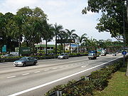
The Ayer Rajah Expressway (Abbreviation
: AYE; ; ; ) extends from the western end of the East Coast Parkway
in the south of Singapore
to Tuas
in the west near the Tuas Second Link to Malaysia. Together with the East Coast Parkway
, it forms a second east-west link to complement the role played by the Pan Island Expressway
.
Construction on the expressway commenced in 1983, with the first two phases completed by 1988. This section involved the widening of several existing roads along the way, such as Ayer Rajah Road and Upper Ayer Rajah Road, as well as the construction of what was then the longest road viaduct
, the Keppel Viaduct, from where the eastern end of the expressway commences. This section extended for 14 kilometres (8.7 mi) and ended at the Teban Flyover with Jurong Town Hall Road.
In 1998, the expressway was extended to Tuas
from the Teban Flyover in conjunction with the opening of the Tuas Second Link to Johor
. This construction, which followed the alignment of Jalan Ahmad Ibrahim, involved the expansion of the existing road to match with the width of the rest of the AYE, construction of "filter" roads on both sides of the expressway (which eventually took the name of Jalan Ahmad Ibrahim), and the building of five flyovers and two underpasses. It meets up with the Pan Island Expressway
at the Tuas Flyover.
Abbreviation
An abbreviation is a shortened form of a word or phrase. Usually, but not always, it consists of a letter or group of letters taken from the word or phrase...
: AYE; ; ; ) extends from the western end of the East Coast Parkway
East Coast Parkway
The East Coast Parkway is an expressway that runs along the southeastern coast of Singapore. The expressway is approximately in length, and connects Singapore Changi Airport in the east to the Benjamin Sheares Bridge in the south of the main island before it links with the Ayer Rajah Expressway...
in the south of Singapore
Singapore
Singapore , officially the Republic of Singapore, is a Southeast Asian city-state off the southern tip of the Malay Peninsula, north of the equator. An island country made up of 63 islands, it is separated from Malaysia by the Straits of Johor to its north and from Indonesia's Riau Islands by the...
to Tuas
Tuas
Tuas is largely an industrial zone located in the western part of Singapore. The Tuas Planning Area is located within the West Region, and is bounded by Tengeh Reservoir to the north, Strait of Johor to the west, Straits of Singapore to the south, and the Pan Island Expressway to the east.It is...
in the west near the Tuas Second Link to Malaysia. Together with the East Coast Parkway
East Coast Parkway
The East Coast Parkway is an expressway that runs along the southeastern coast of Singapore. The expressway is approximately in length, and connects Singapore Changi Airport in the east to the Benjamin Sheares Bridge in the south of the main island before it links with the Ayer Rajah Expressway...
, it forms a second east-west link to complement the role played by the Pan Island Expressway
Pan Island Expressway
The Pan Island Expressway is the oldest and longest of Singapore's expressways. Currently, it is also Singapore's longest road. It extends along the length of the island, connecting Tuas in the west to Singapore Changi Airport in the east. Its length is .-Construction:Construction of the PIE...
.
Construction on the expressway commenced in 1983, with the first two phases completed by 1988. This section involved the widening of several existing roads along the way, such as Ayer Rajah Road and Upper Ayer Rajah Road, as well as the construction of what was then the longest road viaduct
Viaduct
A viaduct is a bridge composed of several small spans. The term viaduct is derived from the Latin via for road and ducere to lead something. However, the Ancient Romans did not use that term per se; it is a modern derivation from an analogy with aqueduct. Like the Roman aqueducts, many early...
, the Keppel Viaduct, from where the eastern end of the expressway commences. This section extended for 14 kilometres (8.7 mi) and ended at the Teban Flyover with Jurong Town Hall Road.
In 1998, the expressway was extended to Tuas
Tuas
Tuas is largely an industrial zone located in the western part of Singapore. The Tuas Planning Area is located within the West Region, and is bounded by Tengeh Reservoir to the north, Strait of Johor to the west, Straits of Singapore to the south, and the Pan Island Expressway to the east.It is...
from the Teban Flyover in conjunction with the opening of the Tuas Second Link to Johor
Johor
Johor is a Malaysian state, located in the southern portion of Peninsular Malaysia. It is one of the most developed states in Malaysia. The state capital city and royal city of Johor is Johor Bahru, formerly known as Tanjung Puteri...
. This construction, which followed the alignment of Jalan Ahmad Ibrahim, involved the expansion of the existing road to match with the width of the rest of the AYE, construction of "filter" roads on both sides of the expressway (which eventually took the name of Jalan Ahmad Ibrahim), and the building of five flyovers and two underpasses. It meets up with the Pan Island Expressway
Pan Island Expressway
The Pan Island Expressway is the oldest and longest of Singapore's expressways. Currently, it is also Singapore's longest road. It extends along the length of the island, connecting Tuas in the west to Singapore Changi Airport in the east. Its length is .-Construction:Construction of the PIE...
at the Tuas Flyover.
List of exits
| No. | Eastbound exit to road (destinations) | Interchange | Type | No. | Westbound exit to road (destinations) |
| End of expressway (ECP East Coast Parkway The East Coast Parkway is an expressway that runs along the southeastern coast of Singapore. The expressway is approximately in length, and connects Singapore Changi Airport in the east to the Benjamin Sheares Bridge in the south of the main island before it links with the Ayer Rajah Expressway... ) |
Keppel Viaduct | - | Start of expressway | ||
| 2B | Keppel Road | 2A | Keppel Road | ||
| 2C | Central Expressway (CTE) | Radin Mas Flyover | No exit | ||
| 3 | Lower Delta Road | Lower Delta Flyover | Diamond Diamond interchange A diamond interchange is a common type of road junction, used where a freeway crosses a minor road. The freeway itself is grade-separated from the minor road, one crossing the other over a bridge... |
3 | Lower Delta Road |
| 6 | Alexandra Road | Gillman Flyover | Diamond | No exit | |
| 7A | Queensway and Normanton Park | Diamond | 7A | Queensway and Normanton Park | |
| 7B | Portsdown Road | - | LILO Right-in/right-out Right-in/right-out and left-in/left-out refer to a type of road intersection where turning movements of vehicles are restricted. A RIRO permits only right turns and a LILO permits only left turns. RIRO is usual where vehicles drive on the right, and LILO is usual where vehicles drive on the left... |
No exit | |
| 8 | North Buona Vista Road and South Buona Vista Road | Buona Vista Flyover | Cloverturbine | 8 | North Buona Vista Road and South Buona Vista Road |
| 9 | Clementi Road | University Flyover | Cloverturbine | 9 | Clementi Road |
| 10B | Clementi Avenue 2 | Clementi Flyover | LILO | 10A | Clementi Avenue 2 |
| 11 | Clementi Avenue 6 | Pandan Flyover | Trumpet | 11 | Clementi Avenue 6 and West Coast Way |
| 13 | Jurong Town Hall Road | Teban Flyover | Diamond | 13 | Jurong Town Hall Road |
| No exit | - | LILO | 14 | Penjuru Road | |
| 15B | Yuan Ching Road | - | LILO | No exit | |
| No exit | Corporation Flyover | Diamond | 15A | Corporation Road and Jurong Port Road | |
| 17 | Jalan Boon Lay, Jurong Pier Road, Corporation Road and Jurong Port Road | Jurong Hill Flyover | Diamond | 17 | Jalan Boon Lay and Jurong Pier Road |
| 18 | First Lok Yang Road, Pioneer Road North and Pioneer Road | Pioneer Flyover | Stacked roundabout | 18 | Pioneer Road North and Pioneer Road |
| 20 | Benoi Road | Benoi Flyover | SPUI Spui Spui is a Dutch term meaning a specific type of small sluice used for refreshing the network of waterways in a village or town. It may refer to the following things:*Spui, a river in the Netherlands... |
20 | Benoi Road |
| 22 | Tuas Road and Pan-Island Expressway (PIE) | Tuas Flyover | Stacked roundabout | 22 | Tuas Road and Pan-Island Expressway (PIE) |
| 24 | Tuas West Road | Tuas West Underpass | 24 | Tuas Avenue 8 and Tuas West Road | |
| Start of expressway | Tuas Checkpoint Viaduct | - | 26B | Tuas West Drive | |
| End of expressway (Second Link Malaysia-Singapore Second Link Malaysia–Singapore Second Link is a bridge connecting Singapore and Johor, Malaysia. In Singapore, it is officially known as the Tuas Second Link. The bridge was built to reduce the traffic congestion at the Johor–Singapore Causeway, and was opened to traffic on 2 January 1998... ) |
|||||