
Freedom, Maine
Encyclopedia
Freedom is a town
in Waldo County
, Maine
, United States
. The population was 645 at the 2000 census
. Freedom is a residential and recreational area.
in the Revolutionary War
. First called Smithstown Plantation, it was later called Beaver Hill Plantation. During the War of 1812
, the town was incorporated on June 11, 1813 as Freedom, a name which had political significance. Freedom Academy was founded in 1836. The town's population was 716 inhabitants in 1870, and 652 in 1880.
Principal products of farms were hay
and potato
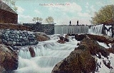
es. Sandy Stream, which is supplied by Sandy and Duck ponds, provided water power for early mills. Industries included a flour
mill, corn
mill, sawmill
for long lumber
, shingle
mill, a shovel
handle factory, a carding
, clothing
and woolen
mill, and a tannery
.
, the town has a total area of 22.2 square miles (57.5 km²), of which, 21.5 square miles (55.7 km²) of it is land and 0.7 square miles (1.8 km²) of it (3.19%) is water. Freedom is drained by Sandy Stream.
of 2000, there were 645 people, 259 households, and 182 families residing in the town. The population density
was 30.0 people per square mile (11.6/km²). There were 321 housing units at an average density of 14.9 per square mile (5.8/km²). The racial makeup of the town was 96.59% White, 0.31% African American, 0.16% Native American, and 2.95% from two or more races. Hispanic or Latino of any race were 2.17% of the population.
There were 259 households out of which 30.9% had children under the age of 18 living with them, 57.1% were married couples
living together, 7.3% had a female householder with no husband present, and 29.7% were non-families. 22.0% of all households were made up of individuals and 7.3% had someone living alone who was 65 years of age or older. The average household size was 2.49 and the average family size was 2.84.
In the town the population was spread out with 24.8% under the age of 18, 5.9% from 18 to 24, 26.7% from 25 to 44, 30.9% from 45 to 64, and 11.8% who were 65 years of age or older. The median age was 42 years. For every 100 females there were 112.9 males. For every 100 females age 18 and over, there were 106.4 males.
The median income for a household in the town was $33,125, and the median income for a family was $35,750. Males had a median income of $33,750 versus $24,688 for females. The per capita income
for the town was $15,492. About 11.6% of families and 15.4% of the population were below the poverty line, including 17.5% of those under age 18 and 10.4% of those age 65 or over.
New England town
The New England town is the basic unit of local government in each of the six New England states. Without a direct counterpart in most other U.S. states, New England towns are conceptually similar to civil townships in other states, but are incorporated, possessing powers like cities in other...
in Waldo County
Waldo County, Maine
Waldo County is a county located in the U.S. state of Maine. As of 2010, the population was 38,786. Its county seat is Belfast.Waldo County was founded on 7 February 1827 from a portion of Hancock County...
, Maine
Maine
Maine is a state in the New England region of the northeastern United States, bordered by the Atlantic Ocean to the east and south, New Hampshire to the west, and the Canadian provinces of Quebec to the northwest and New Brunswick to the northeast. Maine is both the northernmost and easternmost...
, United States
United States
The United States of America is a federal constitutional republic comprising fifty states and a federal district...
. The population was 645 at the 2000 census
United States Census, 2000
The Twenty-second United States Census, known as Census 2000 and conducted by the Census Bureau, determined the resident population of the United States on April 1, 2000, to be 281,421,906, an increase of 13.2% over the 248,709,873 persons enumerated during the 1990 Census...
. Freedom is a residential and recreational area.
History
The area was part of the Plymouth Patent. It was settled in 1794 by Stephen Smith, who was a soldierSoldier
A soldier is a member of the land component of national armed forces; whereas a soldier hired for service in a foreign army would be termed a mercenary...
in the Revolutionary War
American Revolutionary War
The American Revolutionary War , the American War of Independence, or simply the Revolutionary War, began as a war between the Kingdom of Great Britain and thirteen British colonies in North America, and ended in a global war between several European great powers.The war was the result of the...
. First called Smithstown Plantation, it was later called Beaver Hill Plantation. During the War of 1812
War of 1812
The War of 1812 was a military conflict fought between the forces of the United States of America and those of the British Empire. The Americans declared war in 1812 for several reasons, including trade restrictions because of Britain's ongoing war with France, impressment of American merchant...
, the town was incorporated on June 11, 1813 as Freedom, a name which had political significance. Freedom Academy was founded in 1836. The town's population was 716 inhabitants in 1870, and 652 in 1880.
Principal products of farms were hay
Hay
Hay is grass, legumes or other herbaceous plants that have been cut, dried, and stored for use as animal fodder, particularly for grazing livestock such as cattle, horses, goats, and sheep. Hay is also fed to pets such as rabbits and guinea pigs...
and potato
Potato
The potato is a starchy, tuberous crop from the perennial Solanum tuberosum of the Solanaceae family . The word potato may refer to the plant itself as well as the edible tuber. In the region of the Andes, there are some other closely related cultivated potato species...
es. Sandy Stream, which is supplied by Sandy and Duck ponds, provided water power for early mills. Industries included a flour
Flour
Flour is a powder which is made by grinding cereal grains, other seeds or roots . It is the main ingredient of bread, which is a staple food for many cultures, making the availability of adequate supplies of flour a major economic and political issue at various times throughout history...
mill, corn
Maize
Maize known in many English-speaking countries as corn or mielie/mealie, is a grain domesticated by indigenous peoples in Mesoamerica in prehistoric times. The leafy stalk produces ears which contain seeds called kernels. Though technically a grain, maize kernels are used in cooking as a vegetable...
mill, sawmill
Sawmill
A sawmill is a facility where logs are cut into boards.-Sawmill process:A sawmill's basic operation is much like those of hundreds of years ago; a log enters on one end and dimensional lumber exits on the other end....
for long lumber
Lumber
Lumber or timber is wood in any of its stages from felling through readiness for use as structural material for construction, or wood pulp for paper production....
, shingle
Roof shingle
Roof shingles are a roof covering consisting of individual overlapping elements. These elements are typically flat rectangular shapes laid in rows from the bottom edge of the roof up, with each successive higher row overlapping the joints in the row below...
mill, a shovel
Shovel
A shovel is a tool for digging, lifting, and moving bulk materials, such as soil, coal, gravel, snow, sand, or ore. Shovels are extremely common tools that are used extensively in agriculture, construction, and gardening....
handle factory, a carding
Carding
Carding is a mechanical process that breaks up locks and unorganised clumps of fibre and then aligns the individual fibres so that they are more or less parallel with each other. The word is derived from the Latin carduus meaning teasel, as dried vegetable teasels were first used to comb the raw wool...
, clothing
Clothing
Clothing refers to any covering for the human body that is worn. The wearing of clothing is exclusively a human characteristic and is a feature of nearly all human societies...
and woolen
Woolen
Woolen or woollen is a type of yarn made from carded wool. Woolen yarn is soft, light, stretchy, and full of air. It is thus a good insulator, and makes a good knitting yarn...
mill, and a tannery
Tanning
Tanning is the making of leather from the skins of animals which does not easily decompose. Traditionally, tanning used tannin, an acidic chemical compound from which the tanning process draws its name . Coloring may occur during tanning...
.
Geography
According to the United States Census BureauUnited States Census Bureau
The United States Census Bureau is the government agency that is responsible for the United States Census. It also gathers other national demographic and economic data...
, the town has a total area of 22.2 square miles (57.5 km²), of which, 21.5 square miles (55.7 km²) of it is land and 0.7 square miles (1.8 km²) of it (3.19%) is water. Freedom is drained by Sandy Stream.
Demographics
As of the censusCensus
A census is the procedure of systematically acquiring and recording information about the members of a given population. It is a regularly occurring and official count of a particular population. The term is used mostly in connection with national population and housing censuses; other common...
of 2000, there were 645 people, 259 households, and 182 families residing in the town. The population density
Population density
Population density is a measurement of population per unit area or unit volume. It is frequently applied to living organisms, and particularly to humans...
was 30.0 people per square mile (11.6/km²). There were 321 housing units at an average density of 14.9 per square mile (5.8/km²). The racial makeup of the town was 96.59% White, 0.31% African American, 0.16% Native American, and 2.95% from two or more races. Hispanic or Latino of any race were 2.17% of the population.
There were 259 households out of which 30.9% had children under the age of 18 living with them, 57.1% were married couples
Marriage
Marriage is a social union or legal contract between people that creates kinship. It is an institution in which interpersonal relationships, usually intimate and sexual, are acknowledged in a variety of ways, depending on the culture or subculture in which it is found...
living together, 7.3% had a female householder with no husband present, and 29.7% were non-families. 22.0% of all households were made up of individuals and 7.3% had someone living alone who was 65 years of age or older. The average household size was 2.49 and the average family size was 2.84.
In the town the population was spread out with 24.8% under the age of 18, 5.9% from 18 to 24, 26.7% from 25 to 44, 30.9% from 45 to 64, and 11.8% who were 65 years of age or older. The median age was 42 years. For every 100 females there were 112.9 males. For every 100 females age 18 and over, there were 106.4 males.
The median income for a household in the town was $33,125, and the median income for a family was $35,750. Males had a median income of $33,750 versus $24,688 for females. The per capita income
Per capita income
Per capita income or income per person is a measure of mean income within an economic aggregate, such as a country or city. It is calculated by taking a measure of all sources of income in the aggregate and dividing it by the total population...
for the town was $15,492. About 11.6% of families and 15.4% of the population were below the poverty line, including 17.5% of those under age 18 and 10.4% of those age 65 or over.