
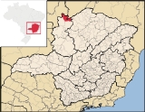
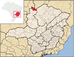
Formoso, Minas Gerais
Encyclopedia
| Formoso | |
|---|---|
| State | Minas Gerais Minas Gerais Minas Gerais is one of the 26 states of Brazil, of which it is the second most populous, the third richest, and the fourth largest in area. Minas Gerais is the Brazilian state with the largest number of Presidents of Brazil, the current one, Dilma Rousseff, being one of them. The capital is the... |
| Area: | 3,699 km² |
| Population: | 6,612 (IBGE 2007) |
| Elevation: | 839 m above sea level |
| Postcode (CEP): | 38690-000 |
| Became a city: | 1962 |
| Mayor: | Luís Carlos da Silva (2005–09) |
| IBGE statistical microregion: | Unaí Micro-region |
| Website: | |
| Coordinates: | 14°57′08"S 46°13′54"W |
City
A city is a relatively large and permanent settlement. Although there is no agreement on how a city is distinguished from a town within general English language meanings, many cities have a particular administrative, legal, or historical status based on local law.For example, in the U.S...
and municipality
Municipality
A municipality is essentially an urban administrative division having corporate status and usually powers of self-government. It can also be used to mean the governing body of a municipality. A municipality is a general-purpose administrative subdivision, as opposed to a special-purpose district...
in northern Minas Gerais
Minas Gerais
Minas Gerais is one of the 26 states of Brazil, of which it is the second most populous, the third richest, and the fourth largest in area. Minas Gerais is the Brazilian state with the largest number of Presidents of Brazil, the current one, Dilma Rousseff, being one of them. The capital is the...
state, Brazil
Brazil
Brazil , officially the Federative Republic of Brazil , is the largest country in South America. It is the world's fifth largest country, both by geographical area and by population with over 192 million people...
. It is located northeast of Brasília, in a pocket where the boundaries of the states of Minas Gerais
Minas Gerais
Minas Gerais is one of the 26 states of Brazil, of which it is the second most populous, the third richest, and the fourth largest in area. Minas Gerais is the Brazilian state with the largest number of Presidents of Brazil, the current one, Dilma Rousseff, being one of them. The capital is the...
, Goiás
Goiás
Goiás is a state of Brazil, located in the central part of the country. The name Goiás comes from the name of an indigenous community...
, and Bahia
Bahia
Bahia is one of the 26 states of Brazil, and is located in the northeastern part of the country on the Atlantic coast. It is the fourth most populous Brazilian state after São Paulo, Minas Gerais and Rio de Janeiro, and the fifth-largest in size...
come together.
Formoso is part of the statistical micro-region of Unaí, which consists of the municipalities of Arinos
Arinos
Arinos is a small city and municipality in northern Minas Gerais state, Brazil. Arinos is located west of the Federal District on the Urucuia River, a major tributary of the São Francisco. The city is 333 km. from Brasília...
, Bonfinópolis de Minas
Bonfinópolis de Minas
Bonfinópolis de Minas is a municipality in the north of the Brazilian state of Minas Gerais. The population was 5,828 in a total area of 1,778 km². The elevation of the municipal seat is 651. It became a city in 1962....
, Buritis
Buritis
Buritis is a small city and municipality in northern Minas Gerais state, Brazil. It is located just south of the Urucuia River, which is a tributary of the São Francisco River.-Highway connections:...
, Cabeceira Grande
Cabeceira Grande
Cabeceira Grande is a municipality in northern part of the Brazilian state of Minas Gerais. It is located just south of the boundary with the Federal District and the national capital Brasília. The population was 6,294 in a total area of 1,026 km²...
, Dom Bosco
Dom Bosco
Dom Bosco is a Brazilian municipality in the north of the state of Minas Gerais. In 2007 the population was 3,781 in a total area of 822 km². The elevation of the municipal seat is 610 meters above sea level....
, Formoso, Natalândia
Natalândia
Natalância is a municipality in the north of the Brazilian state of Minas Gerais. The population was 3,271 in a total area o 471 km².Natalândia lies at an elevation of 550 mts above sea level. It was created as a municipality in 1997. Neighboring municipalities are Unaí, Bonfinópolis de Minas,...
, Unaí
Unaí
Unaí is a city and municipality in northern Minas Gerais state, Brazil, postal code 38610-000.-Location:Unaí is located southeast of Brasília and the Federal District and is linked to that important urban nucleus by highway BR 251, which also connects with BR 040 at Paracatu...
, and Uruana de Minas
Uruana de Minas
Uruana de Minas is a municipality in the north of the Brazilian state of Minas Gerais. As of 2007 the population was 2,777 inhabitants in a total area of 589 km².The elevation of the municipal seat is 530 mts above sea level...
. The population of this micro-region was 133,168 (2000) in a total area of 27,653 km². The population density of the region is very low, 4.82 inhab/km² in 2000.
There are highway connections (MG-400 then GO-108 with Sítio d'Abadia
Sítio d'Abadia
Sítio d'Abadia is a small town and municipality in eastern Goiás state, Brazil.-Location:Sítio d'Abadia is located in a corner of eastern Goiás, 14 kilometers north of the border with Minas Gerais. It is about 30 kilometers west of the border with Bahia...
, 14 kilometers to the north in Goiás. From Sítio there are unpaved (2001) highway connections (GO-112) with Alvorada do Norte
Alvorada do Norte
Alvorada do Norte is a small town and municipality in northeastern Goiás state, Brazil. It is an important commercial center on the Brasília-Salvador highway.-Location:...
on the BR-020 highway (Salvador-Brasília), a distance of 69 kilometers.
Formoso is north of the Parque Nacional Grande Sertão Veredas, created in 1989. This park is a natural area protecting the flora and fauna of the cerrado, but not open to the public.Ambiente Brasil
The economy
The economy is based on cattle raising and agriculture, especially the growing of corn, rice, and soybeans. In 2005 there were 5 small transformation industries and 74 commercial retail establishments. Public administration employed 263 workers. There were no financial institutions as of 2005.The number of motor vehicles was 116 automobiles and 49 pickup trucks in 2007.
Main crops in area in 2006
- Coffee: 115 ha.
- Oranges: 110 ha.
- Hearts of palm: 60 ha.
- Rice: 1,200 ha.
- Beans: 2,300 ha.
- Corn: 6,100 ha.
- Soybeans: 18,900 ha.
Farm data for 2006
- Number of farms: 598
- Agricultural area: 106,302 ha.
- Planted area: 16,600 ha.
- Area of natural pasture: 51,659
- Salaried workers: 49
- Workers who are related to producer: 1,767
Health and education
- Hospitals: none (2005)
- Health clinics: 3
- Primary schools: 10
- Primary school enrollment: 1,725
- Middle schools: 1
- Middle school enrollment: 309
- Higher education: none
- Municipal Human Development IndexHuman Development IndexThe Human Development Index is a composite statistic used to rank countries by level of "human development" and separate "very high human development", "high human development", "medium human development", and "low human development" countries...
: 695 Frigoletto
History
The settlement of this region began in the second half of the eighteenth century with movement along the Picada da Bahia trail, made official in1736 by King João V, who authorized the building of a tax collecting office on the border between Minas Gerais and Goiás, about 70 km from the present-day city of Formoso, in order to control the commerce of gold and cattle between the valley of the São Francisco River
São Francisco River
The São Francisco is a river in Brazil. With a length of , it is the longest river that runs entirely in Brazilian territory, and the fourth longest in South America and overall in Brazil...
and the mines of the region of Goiás. At that time the region was occupied by ranchers from the north of Minas Gerais. The population grew slowly and in
1870 Formoso became a district belonging to the municipality of São Romão
São Romão
São Romão is a Brazilian municipality located in the north of the state of Minas Gerais. In 2007 the population was 9,080 in a total area of 2,432 km². It became a municipality in 1943.-Location and Distances:...
. In 1923 the district was granted status as a vila, or town. In 1962 it became a municipality.