
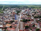
Unaí
Encyclopedia
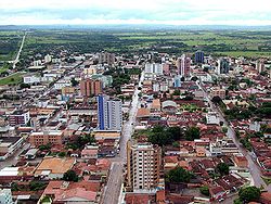
City
A city is a relatively large and permanent settlement. Although there is no agreement on how a city is distinguished from a town within general English language meanings, many cities have a particular administrative, legal, or historical status based on local law.For example, in the U.S...
and municipality
Municipality
A municipality is essentially an urban administrative division having corporate status and usually powers of self-government. It can also be used to mean the governing body of a municipality. A municipality is a general-purpose administrative subdivision, as opposed to a special-purpose district...
in northern Minas Gerais
Minas Gerais
Minas Gerais is one of the 26 states of Brazil, of which it is the second most populous, the third richest, and the fourth largest in area. Minas Gerais is the Brazilian state with the largest number of Presidents of Brazil, the current one, Dilma Rousseff, being one of them. The capital is the...
state, Brazil
Brazil
Brazil , officially the Federative Republic of Brazil , is the largest country in South America. It is the world's fifth largest country, both by geographical area and by population with over 192 million people...
, postal code 38610-000.
Location
Unaí is located southeast of Brasília and the Federal District and is linked to that important urban nucleus by highway BR 251, which also connects with BR 040 at ParacatuParacatu
Paracatu may refer to:*Paracatu, Minas Gerais, a city and a municipality in Minas Gerais state, Brazil*Paracatu River, a river near the city of Paracatu...
. The Preto River
Preto River
Preto River or Prêto River is the name given to many rivers named in Brazil. "Preto" is Portuguese for "black".-Brazil:* Preto da Eva River* Preto de Candeias River* Preto do Crespo River* Prêto do Igapó-Açu River* Preto River...
, which flows out of Lagoa Feia near Formosa and joins the Paracatu River
Paracatu River
The Paracatu River is located mainly in the state of Minas Gerais in Brazil. It is the longest tributary of the São Francisco, draining a basin of about 45,000 km², including 21 municipalities and the Federal District...
, passes by the city. Neighboring municipalities are: Buritis
Buritis
Buritis is a small city and municipality in northern Minas Gerais state, Brazil. It is located just south of the Urucuia River, which is a tributary of the São Francisco River.-Highway connections:...
, Cabeceira Grande
Cabeceira Grande
Cabeceira Grande is a municipality in northern part of the Brazilian state of Minas Gerais. It is located just south of the boundary with the Federal District and the national capital Brasília. The population was 6,294 in a total area of 1,026 km²...
, Paracatu
Paracatu
Paracatu may refer to:*Paracatu, Minas Gerais, a city and a municipality in Minas Gerais state, Brazil*Paracatu River, a river near the city of Paracatu...
, Dom Bosco
Dom Bosco
Dom Bosco is a Brazilian municipality in the north of the state of Minas Gerais. In 2007 the population was 3,781 in a total area of 822 km². The elevation of the municipal seat is 610 meters above sea level....
, Natalândia
Natalândia
Natalância is a municipality in the north of the Brazilian state of Minas Gerais. The population was 3,271 in a total area o 471 km².Natalândia lies at an elevation of 550 mts above sea level. It was created as a municipality in 1997. Neighboring municipalities are Unaí, Bonfinópolis de Minas,...
, Bonfinópolis de Minas
Bonfinópolis de Minas
Bonfinópolis de Minas is a municipality in the north of the Brazilian state of Minas Gerais. The population was 5,828 in a total area of 1,778 km². The elevation of the municipal seat is 651. It became a city in 1962....
, Uruana de Minas
Uruana de Minas
Uruana de Minas is a municipality in the north of the Brazilian state of Minas Gerais. As of 2007 the population was 2,777 inhabitants in a total area of 589 km².The elevation of the municipal seat is 530 mts above sea level...
, Arinos
Arinos
Arinos is a small city and municipality in northern Minas Gerais state, Brazil. Arinos is located west of the Federal District on the Urucuia River, a major tributary of the São Francisco. The city is 333 km. from Brasília...
, Brasilândia de Minas
Brasilândia de Minas
Brasilândia de Minas is a municipality in the north of the Brazilian state of Minas Gerais. As of 2007 the population was 12,821 in a total area of 2,515 km².The elevation of the municipal seat is 530 meters above sea level...
, and João Pinheiro.
Unaí is also the seat of a microregion (number 64) composed of 9 cities with an area of 27,653.10 km² and a population of 133,168 inhabitants. Cities making up the microregion of Unaí are Arinos
Arinos
Arinos is a small city and municipality in northern Minas Gerais state, Brazil. Arinos is located west of the Federal District on the Urucuia River, a major tributary of the São Francisco. The city is 333 km. from Brasília...
, Bonfinópolis de Minas
Bonfinópolis de Minas
Bonfinópolis de Minas is a municipality in the north of the Brazilian state of Minas Gerais. The population was 5,828 in a total area of 1,778 km². The elevation of the municipal seat is 651. It became a city in 1962....
, Buritis
Buritis
Buritis is a small city and municipality in northern Minas Gerais state, Brazil. It is located just south of the Urucuia River, which is a tributary of the São Francisco River.-Highway connections:...
, Cabeceira Grande
Cabeceira Grande
Cabeceira Grande is a municipality in northern part of the Brazilian state of Minas Gerais. It is located just south of the boundary with the Federal District and the national capital Brasília. The population was 6,294 in a total area of 1,026 km²...
, Dom Bosco
Dom Bosco
Dom Bosco is a Brazilian municipality in the north of the state of Minas Gerais. In 2007 the population was 3,781 in a total area of 822 km². The elevation of the municipal seat is 610 meters above sea level....
, Formoso
Formoso, Minas Gerais
Formoso is a small city and municipality in northern Minas Gerais state, Brazil. It is located northeast of Brasília, in a pocket where the boundaries of the states of Minas Gerais, Goiás, and Bahia come together....
, Natalândia
Natalândia
Natalância is a municipality in the north of the Brazilian state of Minas Gerais. The population was 3,271 in a total area o 471 km².Natalândia lies at an elevation of 550 mts above sea level. It was created as a municipality in 1997. Neighboring municipalities are Unaí, Bonfinópolis de Minas,...
, Unaí, and Uruana de Minas
Uruana de Minas
Uruana de Minas is a municipality in the north of the Brazilian state of Minas Gerais. As of 2007 the population was 2,777 inhabitants in a total area of 589 km².The elevation of the municipal seat is 530 mts above sea level...
.
Distances to other cities
- Belo Horizonte: 609.93 (7 hrs and 37 min. driving time at 80 km. per hour)
- Uberlândia: 497
- Goiânia: 350
- Rio de Janeiro: 1.015
- São Paulo: 1.166
- Brasília: 170
- Paracatu: 100
- Patos de Minas: 300
Economy
The region has experienced rapid development in recent years after the building of Brasília and the opening up of the cerradoCerrado
The Cerrado, is a vast tropical savanna ecoregion of Brazil, particularly in the states of Gioas and Minas Gerais...
soils to cultivation of soybeans and irrigated rice. There are large herds of cattle—305,000 head (35,000 milking cows)--and extensive plantations of corn, beans, soybeans, sorghum, and rice.
The main agricultural products in planted area in 2006 were oranges, passion fruit, cotton, garlic, rice, beans, corn, soybeans, sorghum, and wheat. There were 8 banks: Banco do Brasil, Bradesco, Caixa Federal de Depósitos, HSBC, Itaú, Mercantil, Crediunai, and Crediparnor.
PLanted area of main crops in 2006
- Soybeans: 83,000 ha.
- Sorghum: 12,000 ha.
- Corn: 34,000 ha.
- Rice: 1,300 ha.
- Beans: 40,000 ha.
- Coffee: 1,635 ha.
- Bananas: 80 ha.
- Oranges: 116 ha.
Farm data for 2006
- Number of farms: 3,596
- Total area: 664,351 ha.
- Planted area: 170,000 ha.
- Area in natural pasture: 313,408 ha.
- Persons working in agriculture: 12,500
Health and education
- Primary schools: 31
- Enrollment: 13,222 (2006)
- Middle and secondary schools: 9
- Enrollment: 4,084
- Health clinics: 19 (2005)
- Hospitals: 4 with 208 beds (43 beds in public hospitals)
There is one institution of higher learning in the city: Faculdade de Ciências de Unaí
Municipal Human Development Index
Human Development Index
The Human Development Index is a composite statistic used to rank countries by level of "human development" and separate "very high human development", "high human development", "medium human development", and "low human development" countries...
- MHDI: .812
- Ranking in the state: 21 out of 853 municipalities in 2000
- Ranking in the country: 343 out of 5,138 municipalities in 2000
- Literacy rate: .87%
- Life expectancy: 74.7