

Fleam Dyke
Encyclopedia
Cambridgeshire
Cambridgeshire is a county in England, bordering Lincolnshire to the north, Norfolk to the northeast, Suffolk to the east, Essex and Hertfordshire to the south, and Bedfordshire and Northamptonshire to the west...
, England
England
England is a country that is part of the United Kingdom. It shares land borders with Scotland to the north and Wales to the west; the Irish Sea is to the north west, the Celtic Sea to the south west, with the North Sea to the east and the English Channel to the south separating it from continental...
, generally assumed to be Anglo-Saxon
Anglo-Saxons
Anglo-Saxon is a term used by historians to designate the Germanic tribes who invaded and settled the south and east of Great Britain beginning in the early 5th century AD, and the period from their creation of the English nation to the Norman conquest. The Anglo-Saxon Era denotes the period of...
of origin. As a few potsherds of the early and late Bronze age
Bronze Age
The Bronze Age is a period characterized by the use of copper and its alloy bronze as the chief hard materials in the manufacture of some implements and weapons. Chronologically, it stands between the Stone Age and Iron Age...
were found in the most eastern part of the dyke it seems that much older earthworks have been used. The archaeologist
Archaeology
Archaeology, or archeology , is the study of human society, primarily through the recovery and analysis of the material culture and environmental data that they have left behind, which includes artifacts, architecture, biofacts and cultural landscapes...
Prof. McKenny Hughes
Woodwardian Professor of Geology
The Woodwardian Professor of Geology is a professorship held in the Department of Earth Sciences at the University of Cambridge. It was founded by John Woodward in 1728...
therefore preferred to speak of 'multi-period dykes' while more recently Alison Taylor cautiously concluded that though most defensive dykes in Cambridgeshire have been shown to be Anglo-Saxon in their final phase, they often seem to be preceded by Iron Age
Iron Age
The Iron Age is the archaeological period generally occurring after the Bronze Age, marked by the prevalent use of iron. The early period of the age is characterized by the widespread use of iron or steel. The adoption of such material coincided with other changes in society, including differing...
works, and elsewhere in East Anglia
East Anglia
East Anglia is a traditional name for a region of eastern England, named after an ancient Anglo-Saxon kingdom, the Kingdom of the East Angles. The Angles took their name from their homeland Angeln, in northern Germany. East Anglia initially consisted of Norfolk and Suffolk, but upon the marriage of...
they are commonly Iron Age
Iron Age
The Iron Age is the archaeological period generally occurring after the Bronze Age, marked by the prevalent use of iron. The early period of the age is characterized by the widespread use of iron or steel. The adoption of such material coincided with other changes in society, including differing...
in date.
The main surviving section of the dyke consists of a massive bank and ditch running 4 miles between Fulbourn
Fulbourn
Fulbourn is a village in Cambridgeshire, England. The term for a resident of the village is "Fulbourner".- Geography :Fulbourn lies about five miles south-east of the centre of Cambridge, separated from the outer city boundary by farmland and the grounds of Fulbourn Hospital. The village itself is...
and Balsham
Balsham
Balsham is a rural village and civil parish in the county of Cambridgeshire, United Kingdom which has much expanded since the 1960s and is now one of several dormitory settlements of Cambridge...
. There is also a section near Fen Ditton
Fen Ditton
Fen Ditton is a village on the northeast edge of Cambridge in Cambridgeshire, England. The parish covers an area of Fen Ditton lies on the east bank of the River Cam, on the road from Cambridge to Clayhithe, and close to junction 34 of the A14...
, or High Ditch, which acquired its name (Dittone, meaning "the village by the ditch") from its proximity to the Dyke.
History
In the late 6th or early 7th century competition between neighbouring Saxon tribes was particularly fierce. It is believed that the dyke would have been used to demarcate the boundary of a tribe's influence as well as a barrier to the British tribes to the west.At its creation, the chalk barrier ran from The Fens
The Fens
The Fens, also known as the , are a naturally marshy region in eastern England. Most of the fens were drained several centuries ago, resulting in a flat, damp, low-lying agricultural region....
in the north-west to the clay woodlands in the south making circumvention difficult. Findings such as the small quantity of silt in the ditch fills also suggest that the dyke fell into disuse soon after it was built.
The dyke is one of several earthworks in south Cambridgeshire designed to control movement along the ancient Roman roads. The others include Devil's Dyke
Devil's Dyke, Cambridgeshire
The Devil's Dyke is an earthwork in the English county of Cambridgeshire. It consists of a long bank and ditch that runs in a south-east direction from the small village of Reach to nearby Woodditton...
, Brent Ditch
Brent Ditch
Brent Ditch is generally assumed to be an Anglo-Saxon earthwork in Southern Cambridgeshire, England built around the 6th and 7th Centuries . However most of its structure has been lost over time...
and Bran ditch
Bran ditch
Bran Ditch or Heydon Ditch is generally assumed to be an Anglo-Saxon earthwork in southern Cambridgeshire, England.Most of the ditch has been lost to agriculture over time, but its line its marked throughout by both hedgerow and the route of the Harcomlow Way and Icknield Way paths...
.
Black Ditches, Cavenham
Black Ditches, Cavenham
Black Ditches is an earthwork close to Cavenham, which is generally assumed to be Anglo-Saxon, dating to the 6th or 7th century. It runs south-east from the village for approximately , remaining almost unbroken as a single embankment along its length, reaching a height of almost at points...
is a fifth earthwork guarding the ancient Icknield Way and can be found in Suffolk just north west of Bury St Edmunds
Heritage
English Heritage
English Heritage . is an executive non-departmental public body of the British Government sponsored by the Department for Culture, Media and Sport...
as a Scheduled Ancient Monument
Scheduled Ancient Monument
In the United Kingdom, a scheduled monument is a 'nationally important' archaeological site or historic building, given protection against unauthorized change. The various pieces of legislation used for legally protecting heritage assets from damage and destruction are grouped under the term...
, as well as Site of Special Scientific Interest
Site of Special Scientific Interest
A Site of Special Scientific Interest is a conservation designation denoting a protected area in the United Kingdom. SSSIs are the basic building block of site-based nature conservation legislation and most other legal nature/geological conservation designations in Great Britain are based upon...
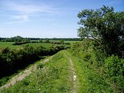
. A well-kept footpath runs the full length of the dyke.
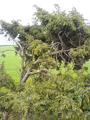
The path is also home to several rare species of flora and is an excellent example of a chalk grassland. It is on a strech of these open grassland banks south of the A11 that rare examples of the Common Juniper
Juniper
Junipers are coniferous plants in the genus Juniperus of the cypress family Cupressaceae. Depending on taxonomic viewpoint, there are between 50-67 species of juniper, widely distributed throughout the northern hemisphere, from the Arctic, south to tropical Africa in the Old World, and to the...
tree can be found