

Bran ditch
Encyclopedia
Anglo-Saxons
Anglo-Saxon is a term used by historians to designate the Germanic tribes who invaded and settled the south and east of Great Britain beginning in the early 5th century AD, and the period from their creation of the English nation to the Norman conquest. The Anglo-Saxon Era denotes the period of...
earthwork in southern Cambridgeshire
Cambridgeshire
Cambridgeshire is a county in England, bordering Lincolnshire to the north, Norfolk to the northeast, Suffolk to the east, Essex and Hertfordshire to the south, and Bedfordshire and Northamptonshire to the west...
, England
England
England is a country that is part of the United Kingdom. It shares land borders with Scotland to the north and Wales to the west; the Irish Sea is to the north west, the Celtic Sea to the south west, with the North Sea to the east and the English Channel to the south separating it from continental...
.
Most of the ditch has been lost to agriculture over time, but its line its marked throughout by both hedgerow and the route of the Harcomlow Way and Icknield Way
Icknield Way
The Icknield Way is an ancient trackway in southern England. It follows the chalk escarpment that includes the Berkshire Downs and Chiltern Hills.-Background:...
paths. It would have consisted of an earth bank and ditch running for approximately 2 km (~1mile) north-west from higher land at Heydon to the golf course at Heydon Grange.
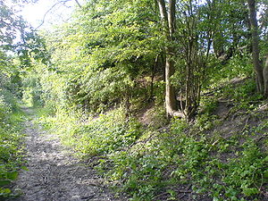
Beginning on the fringes of Heydon Village, the ditch's course quickly descends from the higher ground (120m) to the flatter agricultural landscape below (55m). On the hill the earthworks are lightly wooded and it is at this higher point at which the dyke's course and workings are best viewed. Its line to the north can be seen through gaps in the trees in the fields below and what remains of its banks are best preserved there. For a short distance the workings are several metres high as the footpath descends the hill through the ditch and onto the flatter ground below. Down here only a slightly raised straight path and a hedgerow line are clues to former glories.
History
Using data from the other dykes, archaeological Carbon-14Carbon-14
Carbon-14, 14C, or radiocarbon, is a radioactive isotope of carbon with a nucleus containing 6 protons and 8 neutrons. Its presence in organic materials is the basis of the radiocarbon dating method pioneered by Willard Libby and colleagues , to date archaeological, geological, and hydrogeological...
dating suggests that work on the dyke(s) made during the 6th and 7th centuries. It would have been used as a defensive structure as well as a means controlling trade along Roman roads that cross the dyke, including the Icknield Way
Icknield Way
The Icknield Way is an ancient trackway in southern England. It follows the chalk escarpment that includes the Berkshire Downs and Chiltern Hills.-Background:...
.
Like the other works to the East, it fell from use with in a few hundred years of concept. At a much latter date it is assumed that much of its length would have been flattened as part of agriculture reforms.
The dyke is one of the shorter of several earthworks in south Cambridgeshire designed to control movement along the ancient Roman roads. The others are Devil's Dyke
Devil's Dyke, Cambridgeshire
The Devil's Dyke is an earthwork in the English county of Cambridgeshire. It consists of a long bank and ditch that runs in a south-east direction from the small village of Reach to nearby Woodditton...
, Fleam Dyke
Fleam Dyke
Fleam Dyke is an earthwork in eastern Cambridgeshire, England, generally assumed to be Anglo-Saxon of origin. As a few potsherds of the early and late Bronze age were found in the most eastern part of the dyke it seems that much older earthworks have been used. The archaeologist Prof...
and Brent Ditch
Brent Ditch
Brent Ditch is generally assumed to be an Anglo-Saxon earthwork in Southern Cambridgeshire, England built around the 6th and 7th Centuries . However most of its structure has been lost over time...
. Black Ditches, Cavenham
Black Ditches, Cavenham
Black Ditches is an earthwork close to Cavenham, which is generally assumed to be Anglo-Saxon, dating to the 6th or 7th century. It runs south-east from the village for approximately , remaining almost unbroken as a single embankment along its length, reaching a height of almost at points...
is a fifth earthwork guarding the ancient Icknield Way and can be found in Suffolk
Suffolk
Suffolk is a non-metropolitan county of historic origin in East Anglia, England. It has borders with Norfolk to the north, Cambridgeshire to the west and Essex to the south. The North Sea lies to the east...
just north west of Bury St Edmunds. Much has been lost over time and the ditch is the least preserved of the five structures.