

Filchner-Ronne Ice Shelf
Encyclopedia
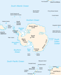
Weddell Sea
The Weddell Sea is part of the Southern Ocean and contains the Weddell Gyre. Its land boundaries are defined by the bay formed from the coasts of Coats Land and the Antarctic Peninsula. The easternmost point is Cape Norvegia at Princess Martha Coast, Queen Maud Land. To the east of Cape Norvegia is...
.
Description
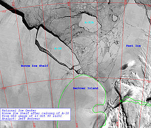
The seaward side of the Filchner-Ronne ice shelfIce shelf
An ice shelf is a thick, floating platform of ice that forms where a glacier or ice sheet flows down to a coastline and onto the ocean surface. Ice shelves are only found in Antarctica, Greenland and Canada. The boundary between the floating ice shelf and the grounded ice that feeds it is called...
is divided into Eastern (Filchner) 79°00′S 40°00′W and the larger Western (Ronne) 78°30′S 61°00′W sections by Berkner Island
Berkner Island
Berkner Island or Berkner Ice Rise or Hubley Island is a high and completely ice-covered large island about long and wide in Antarctica, with an area of . It is the second largest island of both Antarctica and the British Antarctic Territory, after Alexander Island. It is also located within the...
. The whole ice shelf covers some 430,000 km², making it the second largest ice shelf in Antarctica, after the Ross Ice Shelf
Ross Ice Shelf
The Ross Ice Shelf is the largest ice shelf of Antarctica . It is several hundred metres thick. The nearly vertical ice front to the open sea is more than 600 km long, and between 15 and 50 metres high above the water surface...
. It grows perpetually due to a flow of inland ice sheets. From time to time, when the shearing stresses exceed the strength of the ice, cracks form and large parts of the ice sheet separate from the ice shelf and continue as iceberg
Iceberg
An iceberg is a large piece of ice from freshwater that has broken off from a snow-formed glacier or ice shelf and is floating in open water. It may subsequently become frozen into pack ice...
s. This is known as calving
Ice calving
Ice calving, also known as glacier calving or iceberg calving, is a form of ice ablation or ice disruption. It is the sudden release and breaking away of a mass of ice from a glacier, iceberg, ice front, ice shelf, or crevasse...
.
The Ronne ice shelf is the larger and western part of the Filchner-Ronne ice shelf. It is bounded on the west by the base of the Antarctic Peninsula
Antarctic Peninsula
The Antarctic Peninsula is the northernmost part of the mainland of Antarctica. It extends from a line between Cape Adams and a point on the mainland south of Eklund Islands....
(Graham Land
Graham Land
Graham Land is that portion of the Antarctic Peninsula which lies north of a line joining Cape Jeremy and Cape Agassiz. This description of Graham Land is consistent with the 1964 agreement between the British Antarctic Place-names Committee and the US Advisory Committee on Antarctic Names, in...
with Zumberge Coast
Zumberge Coast
Zumberge Coast is that portion of the southeast coast of Palmer Land between Cape Zumberge and the south entrance point to Hercules Inlet. Overlooking the west part of Ronne Ice Shelf, this coast was mapped by United States Geological Survey from U.S. Navy aerial photographs taken 1961-66 and...
and Orville Coast
Orville Coast
Orville Coast is that portion of the coast of Antarctica lying west of Ronne Ice Shelf between Cape Adams and Cape Zumberge. It was discovered by the Ronne Antarctic Research Expedition , 1947-48, under Ronne, who named this coast for Capt. Howard T. Orville, USN, Head of the Naval Aerological...
) and Ellsworth Land
Ellsworth Land
Ellsworth Land is that portion of the Antarctic continent bounded on the west by Marie Byrd Land, on the north by Bellingshausen Sea, on the northeast by the base of Antarctic Peninsula, and on the east by the western margin of Ronne Ice Shelf. It extends between 103°24'W and 79°45'W...
. Commander Finn Ronne
Finn Ronne
Finn Ronne was a U.S. Antarctic explorer.-Background:Finn Ronne was born in Horten, in Vestfold county, Norway. His father, Martin Rønne , was a polar explorer and served in Roald Amundsen's successful expedition to the South Pole...
, USNR, leader of the Ronne Antarctic Research Expedition
Ronne Antarctic Research Expedition
The Ronne Antarctic Research Expedition was an expedition from 1947-1948 which researched the area surrounding the head of the Weddell Sea in Antarctica.-Background:...
(RARE) in 1947-48, discovered and photographed a strip along the entire northern portion of this ice shelf in two aircraft flights in November and December 1947. He named it the "Lassiter Shelf Ice" and gave the name "Edith Ronne Land" to the land presumed to lie south of it. In 1957-58, the US-IGY party at Ellsworth Station
Ellsworth Station
The Ellsworth Station was an Antarctic base established by the United States during the 1957 International Geophysical Year. The base was soon handed over to Argentina and subsequently abandoned and covered with ice in 1962.-History:...
, under now Captain Ronne, determined that the ice shelf was larger than previously charted, that it extends southward to preempt most of "Edith Ronne Land
Edith Ronne Land
Edith Ronne Land is the name sometimes applied to the sector of Antarctica lying between 36° W and 80° W to the south of the Filchner-Ronne Ice Shelf...
". Inasmuch as Capt. James Lassiter's name has been assigned to a coast of Palmer Land
Palmer Land
Palmer Land is that portion of the Antarctic Peninsula which lies south of a line joining Cape Jeremy and Cape Agassiz. This application of Palmer Land is consistent with the 1964 agreement between US-ACAN and UK-APC, in which the name Antarctic Peninsula was approved for the major peninsula of...
, the Advisory Committee on Antarctic Names
Advisory Committee on Antarctic Names
The Advisory Committee on Antarctic Names is an advisory committee of the United States Board on Geographic Names responsible for recommending names for features in Antarctica...
(US-ACAN) approved the name Ronne Ice Shelf for this large ice shelf, on the basis of first sighting and exploration of the ice shelf by Ronne and parties under his leadership. The shelf is therefore named for Edith Ronne
Edith Ronne
Edith "Jackie" Ronne was an American explorer of Antarctica and the first woman in the world to be a working member of an Antarctic expedition. She is also the namesake of the Ronne Ice Shelf.-Biography:...
, the wife of Finn Ronne and RARE
Ronne Antarctic Research Expedition
The Ronne Antarctic Research Expedition was an expedition from 1947-1948 which researched the area surrounding the head of the Weddell Sea in Antarctica.-Background:...
Expedition member.
The Filchner ice shelf is the eastern part of the Filchner-Ronne ice shelf. It is bounded on the west by Berkner Island and on the east by Coats Land
Coats Land
Coats Land is a region in Antarctica which lies westward of Queen Maud Land and forms the eastern shore of the Weddell Sea, extending in a general northeast-southwest direction between 20º00´W and 36º00´W. The northeast part was discovered from the Scotia by William S. Bruce, leader of the Scottish...
. The east part of this shelf was discovered in January-February 1912 by the German Antarctic Expedition under Wilhelm Filchner
Wilhelm Filchner
Wilhelm Filchner was a German explorer.At the age of 21, he participated in his first expedition, which led him to Russia. Two years later, he travelled alone and on horseback through the Pamir Mountains, from Osh to Murgabh to the upper Wakhan to Tashkurgan and back...
. Filchner named the feature for Kaiser Wilhelm
Kaiser Wilhelm
Kaiser Wilhelm is a common reference to two German emperors:* Wilhelm I, German Emperor , King of Prussia; became the first Kaiser of a united Germany...
, but the Emperor requested it be named for its discoverer. The shelf is nourished primarily by the Slessor Glacier
Slessor Glacier
The Slessor Glacier is a glacier at least 120 km long and 80 km wide, flowing west into the Filchner Ice Shelf to the north of the Shackleton Range. First seen from the air and mapped by the Commonwealth Trans-Antarctic Expedition in 1956...
, the Recovery Glacier
Recovery Glacier
The Recovery Glacier is a glacier flowing west along the southern side of the Shackleton Range in Antarctica. First seen from the air and examined from the ground by the CTAF in 1957, it was so named because of the recovery of the expedition's vehicles which repeatedly broke into bridged crevasses...
, and the Support Force Glacier
Support Force Glacier
Support Force Glacier is a major glacier in the Pensacola Mountains, draining northward between the Forrestal Range and Argentina Range to the Filchner-Ronne Ice Shelf. Mapped by the United States Geological Survey from surveys and US Navy air photos, 1956-66. Named by US-ACAN for the U.S...
, all located east of Berkner Island.
In October 1998, the iceberg A-38 broke off the Filchner-Ronne ice shelf. It had a size of roughly 150 by 50 km and was thus larger than Delaware
Delaware
Delaware is a U.S. state located on the Atlantic Coast in the Mid-Atlantic region of the United States. It is bordered to the south and west by Maryland, and to the north by Pennsylvania...
. It later broke up into three parts. A similar-sized calving in May 2000 created an iceberg 167 by 32 km in extent, dubbed A-43 - the disintegration of this is thought to have been responsible for the November 2006 sighting of several large icebergs from the coast of the South Island
South Island
The South Island is the larger of the two major islands of New Zealand, the other being the more populous North Island. It is bordered to the north by Cook Strait, to the west by the Tasman Sea, to the south and east by the Pacific Ocean...
of New Zealand
New Zealand
New Zealand is an island country in the south-western Pacific Ocean comprising two main landmasses and numerous smaller islands. The country is situated some east of Australia across the Tasman Sea, and roughly south of the Pacific island nations of New Caledonia, Fiji, and Tonga...
, the first time that any icebergs had been observed from the New Zealand mainland since 1931. A large group of small icebergs (the largest some 1000 metres in length), were seen off the southeast coast of the island, with one of them drifting close enough to shore to be visible from the hills above the city of Dunedin
Dunedin
Dunedin is the second-largest city in the South Island of New Zealand, and the principal city of the Otago Region. It is considered to be one of the four main urban centres of New Zealand for historic, cultural, and geographic reasons. Dunedin was the largest city by territorial land area until...
. If these were indeed the remnants of this calving, then over the course of five and a half years they had travelled slowly north and also east around over half the globe, a journey of some 13,500 km.
From January 12 and January 13, 2010, an area of sea ice larger than the state of Rhode Island broke away from the Ronne-Filchner Ice Shelf and shattered into many smaller pieces. The Moderate Resolution Imaging Spectroradiometer (MODIS) on NASA’s Aqua and Terra satellites captured this event in this series of photo-like images.
The ice of the Filchner-Ronne ice shelf can be as thick as 600 m; the water below is about 1400 m deep at the deepest point.
The international Filchner-Ronne Ice Shelf Programme (FRISP) was initiated in 1973 to study the glaciological regime of the ice shelf.