
List of Antarctic ice shelves
Encyclopedia
Scientific Committee on Antarctic Research
The Scientific Committee on Antarctic Research is an interdisciplinary body of the International Council for Science . It was established in February 1958 to continue the international coordination of Antarctic scientific activities that had begun during the International Geophysical Year of 1957-58...
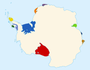
, Gazetteer. The individual ice shelf areas are listed below, in a clockwise manner, starting in the west of East Antarctica
East Antarctica
East Antarctica, also called Greater Antarctica, constitutes the majority of the Antarctic continent, lying on the Indian Ocean side of the Transantarctic Mountains...
:
|
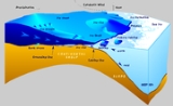
Shackleton Ice Shelf Shackleton Ice Shelf is an extensive ice shelf fronting the coast of East Antarctica for about 384 km , projecting seaward about 145 km in the western portion and 64 km in the east. It occupies an area of 33,820 km². It is part of Mawson Sea and separates the Queen Mary Coast to the west from... Moscow University Ice Shelf Moscow University Ice Shelf is a narrow ice shelf, about 120 miles long, which fringes Sabrina Coast between Totten Glacier and Paulding Bay. Dalton Iceberg Tongue extends north from the east part of the shelf... Voyeykov Ice Shelf Voyeykov Ice Shelf , is an ice shelf fringing the coast between Paulding Bay and Cape Goodenough, Antarctica. Mapped by the Soviet Antarctic Expedition and named after Aleksandr I. Voyeykov , a Russian climatologist.... Cook Ice Shelf Cook Ice Shelf is an ice shelf about wide, occupying a deep recession of the coastline between Cape Freshfield and Cape Hudson, to the east of Deakin Bay. This indentation was called Cook Bay by the Australasian Antarctic Expedition, 1911–14, under Douglas Mawson, who named it for Joseph Cook,... Slava Ice Shelf Slava Ice Shelf , is an ice shelf along the coast of Antarctica between Mawson Peninsula and Cape Andreyev. The feature was photographed from the air by U.S. Navy Operation Highjump in 1947. The area was photographed in 1958 by the Soviet Antarctic Expedition which applied the name "Zaliv Slava"... Gillett Ice Shelf Gillett Ice Shelf is a narrow ice shelf occupying an indentation of the coast off the Wilson Hills between the peninsula containing the Holladay Nunataks and the Anderson Peninsula. Mapped by United States Geological Survey from surveys and U.S. Navy air photos, 1960-63. Named by Advisory... Nansen Ice Sheet Nansen Ice Sheet , or Nansen Ice Shelf, is a 30-mile long by 10 mile wide ice shelf. It is nourished by the Priestley and Reeves Glaciers and abutting the north side of the Drygalski Ice Tongue, along the coast of Victoria Land, Antarctica... McMurdo Ice Shelf McMurdo Ice Shelf is the portion of the Ross Ice Shelf bounded by McMurdo Sound and Ross Island on the north and Minna Bluff on the south. Studies show this feature has characteristics quite distinct from the Ross Ice Shelf and merits individual naming. A.J... Ross Ice Shelf The Ross Ice Shelf is the largest ice shelf of Antarctica . It is several hundred metres thick. The nearly vertical ice front to the open sea is more than 600 km long, and between 15 and 50 metres high above the water surface... Swinburne Ice Shelf Swinburne Ice Shelf , is an ice shelf just north of Edward VII Peninsula and the Alexandra Mountains in the southern part of Sulzberger Bay, Antarctica. The ice shelf is 20 miles long and 5 miles wide and extends from Fisher Island to White Islands. It was photographed from aircraft and mapped by... Nickerson Ice Shelf Nickerson Ice Shelf , is an ice shelf about 35 miles wide, lying north of Siemiatkowski Glacier and the western part of Ruppert Coast, Marie Byrd Land, Antarctica. First observed and roughly mapped by the Byrd Antarctic Expedition . Named by Advisory Committee on Antarctic Names for Commander... Getz Ice Shelf Getz Ice Shelf is an Antarctic ice shelf, over 480 km long and from 32 to 96 km wide, bordering the Hobbs and Bakutis Coasts of Marie Byrd Land between McDonald Heights and Martin Peninsula. Several large islands are partially or wholly embedded in the ice shelf.The ice shelf westward of Siple... Dotson Ice Shelf Dotson Ice Shelf is an ice shelf about 48 km wide between Martin and Bear Peninsulas on the coast of Marie Byrd Land in Antarctica.First mapped by USGS from air photos obtained by USN Operation Highjump in January 1947. Named by US-ACAN for Lt. William A... |
Crosson Ice Shelf Crosson Ice Shelf , is an Antarctic ice shelf, about 35 miles wide, located north and northeast of Mount Murphy along the Walgreen Coast of Marie Byrd Land. The ice shelf is nurtured by Smith, Pope, Vane, and Haynes Glaciers. Mapped by U.S. Geological Survey from surveys and U.S. Navy air photos,... Cosgrove Ice Shelf Cosgrove Ice Shelf is a long by wide ice shelf, occupying the inner part of the embayment between King Peninsula and Canisteo Peninsula, Antarctica. It was mapped from air photos taken by U.S. Navy Operation Highjump, 1946–47, and named by the Advisory Committee on Antarctic Names for... Abbot Ice Shelf The Abbot Ice Shelf is an ice shelf long and wide, bordering Eights Coast from Cape Waite to Phrogner Point in Antarctica. Thurston Island lies along the northern edge of the western half of this ice shelf; other sizable islands lie partly or wholly within this shelf.The ice shelf was sighted by... Venable Ice Shelf Venable Ice Shelf is an ice shelf, 40 miles long and 15 miles wide, between Fletcher and Allison Peninsulas, Ellsworth Land. Mapped by United States Geological Survey from surveys and U.S. Navy air photos, 1961-66. Named by Advisory Committee on Antarctic Names for Cdm. J.D. Venable, U.S.... Stange Ice Shelf Stange Ice Shelf , is an Antarctic ice shelf in Stange Sound, English Coast, bounded to the east by Spaatz Island, to the northwest by Smyley Island, and to the west by fast ice in Carroll Inlet. Named in association with Stange Sound. In contrast to the some other ice shelves on the Antarctic... Bach Ice Shelf The Bach Ice Shelf is an ice shelf which is irregular in shape and in extent, occupying an embayment in the south part of Alexander Island entered between Berlioz Point and Rossini Point. A minor embayment in this position first appeared on the charts of the US Antarctic Service, which explored... George VI Ice Shelf The George VI Ice Shelf is an extensive ice shelf that occupies George VI Sound between Alexander Island and Palmer Land in Antarctica. The ice shelf extends from Ronne Entrance, at the southwest end of the sound, to Niznik Island, about south of the north entrance between Cape Brown and Cape... Wordie Ice Shelf The Wordie Ice Shelf was a confluent glacier projecting as an ice shelf into the SE part of Marguerite Bay between Cape Berteaux and Mount Edgell, along the western coast of Antarctic Peninsula.... * Jones Ice Shelf Jones Ice Shelf , was the ice shelf occupying the Jones Channel, between the Arrowsmith Peninsula and Blaiklock Island, on the west coast of Graham Land, Antarctica. Named by the UK Antarctic Place-names Committee in 1981 in association with the channel.The shelf was stable between 1947 and 1969.... * Muller Ice Shelf Muller Ice Shelf, also known as Müller Ice Shelf according to the original German spelling of the family name Müller, was an ice shelf lying southwest of Hooke Point in southwest Lallemand Fjord, Arrowsmith Peninsula, Loubet Coast... * Prince Gustav Ice Shelf Prince Gustav Ice Shelf was an ice shelf of more than 15 nautical miles extent occupying the south part of Prince Gustav Channel, including Rohss Bay, James Ross Island. Named by United Kingdom Antarctic Place-Names Committee in 1990 in association with the channel. The ice shelf has since... * Larsen Ice Shelf The Larsen Ice Shelf is a long, fringing ice shelf in the northwest part of the Weddell Sea, extending along the east coast of Antarctic Peninsula from Cape Longing to the area just southward of Hearst Island... *(Larsen A and B) |
* Indicates the ice shelf has collapsed.