

Eylesbarrow mine
Encyclopedia
Eylesbarrow mine was a tin
mine on Dartmoor
, Devon
, England that was active during the first half of the 19th century. In its early years it was one of the largest and most prosperous of the Dartmoor tin mines, along with Whiteworks mine and the Birch Tor and Vitifer mine
s. Its name has several variant spellings, such as Eylesburrow, Ailsborough, Ellisborough, Hillsborough etc. It was also known as Wheal Ruth for a short period around 1850. The extensive remains lie to the north of the River Plym
, less than a mile north-east of Drizzlecombe
, on the southern shoulder of the hill called Eylesbarrow on top of which are two prominent Bronze Age
barrow
s.
of the mine is granite
. The large mining sett
(about 3 miles by 2 miles) is crossed by many tin-bearing lode
s which are substantially vertical and trend east-north-east. Most of the mine's excavations were made into just three of these lodes and were relatively shallow. The formation of the lodes was accompanied by extensive metasomatism
which converted much of the plagioclase feldspar in the surrounding granite into the soft mineral kaolinite
, and made excavation easier than it would have been in unaltered rock.
The lodes varied in width up to a maximum of around 2.4 ft (0.73 m) and were, at least in the early years of the mine's operation, sometimes of very high quality ore, uncontaminated with other unwanted metalliferous ores. The existence of these high quality ores near the surface led the miners to believe that even better ore existed deeper down, but the history of the mine suggests that this is not the case and the mineralisation becomes patchy at depth.
 Streaming and open-cast mining for tin have taken place in this part of Dartmoor for many centuries. It is believed that the industry on the moor was at its peak as early as the 12th century. For instance, in 1168 men from the nearby village of Sheepstor
are known to have been "tinners". Around 550 years later a document of 1715 stated of Sheepstor Parish that "all the parishioners are tinners", but by this time working for tin on the moor was already in decline, probably because of the exhaustion of the easily-accessible deposits.
Revival came in the late 1780s, fired by the needs and innovations of the industrial revolution. It is possible that some underground working took place on the site of the mine as early as 1790, but the first documentary evidence is an offer for sale of shares in a mine called "Ailsborough" in 1804, and records of tin dues paid from 1806 to 1810.
By 1814 demand had caused the price of tin to rise to about £150 per ton and in that year a mining sett
called "Ellisborough Tin Set" was granted. Extraction started at the mine in February 1815 and by 1820, despite several business difficulties, it was sending quantities of black tin
to Cornwall for smelting. In 1822 the mine opened its own smelting
house on the site—the only one in operation on the moor. There is evidence that black tin was bought from nearby mines for smelting here.
The next ten years or so were the mine's most productive period, despite there being a fall in the price of tin from 1826. In addition to tin, some "Forest Clay" (kaolin) was sold. In 1831 the mine employed over sixty men, but at the end of that year the smelter ceased operation and there is then a four-year gap in the records.
, offering 7,500 shares at £5 each. The mine apparently operated unsuccessfully on a small scale for the next few years while the price of tin fell again. In August 1838 the shares on which £3. 10s had been paid were worth only £2. By early 1840 the shares, by then fully paid-up were worth just £1. By 1841 only three or four men were employed and in 1844, with the price of tin at an all-time low of just over £60 per ton, the mine closed.
In early 1847, with tin back up to around £90 per ton, the mine was again advertised (this time as "Dartmoor Consols Tin Mining Company"), offering 2,048 shares at £2 each. This resurgence of activity was bolstered with glowing reports on the quality of its ore and the previous high returns that had been made despite the shafts being of no great depth. It was also said that the smelting house "can be made fit for use at a very trifling cost" which will make it "a source of great profit".
In June 1847 the mine captain, John Spargo, proposed a number of improvements, including the installation of a 50 ft (15 m) waterwheel and new stamps, and the sinking of new shafts, the whole costing a total of nearly £1,000. Much of this work was undertaken, but by October the same year, the first signs that all was not well appeared in The Mining Journal. The shares had not been well taken up and the lack of money was causing problems. By the following March it was reported that the mine could not continue in operation and a final call of £1 per share was being made to clear the debts of the company. It was clear that no tin had been sold.
Yet another company, calling itself "Aylesborough", was formed during 1848, and sold over £50 worth of black tin. In 1849 Captain Spargo reported that the stamps were working well and a shaft had been deepened to 20 fathoms below adit. But problems reappeared and in 1851 it was advertised—for the last time—as "Wheal Ruth" with 2,700 shares offered at £2 each. This new concern employed only a few men, but operated successfully for a time, selling 1 ton 4 cwt 11 lb of ore for £61. 9s in September 1851 and over two tons for more than £107 in the last quarter of the year. However on 25 September 1852 The Mining Journal ran an advert for the sale of all the mine's equipment by public auction
. Since the price of tin was rising again at this time, it is most likely that the mine had become exhausted of tin that was recoverable economically.
was "coined" (i.e. recorded and taxed) at Tavistock, the nearest stannary town, between the years 1822 and 1831, and this may have been worth almost £30,000. The mine's most productive year was 1825, when 403 blocks of tin weighing over 1,220 cwt in total were coined.
in 1999 with full details entered into the National Monuments Record.
In common with most Dartmoor valleys, the entire valley floor of the upper River Plym
and its tributaries are disturbed by the remains of streamworks. There are also a number of openworks that follow the lodes, and signs of leats and reservoirs and hundreds of prospecting pits. These all represent the efforts of the "old men" who worked the area for tin in the centuries before the mine came into being.
visible at Eylesbarrow, most of which are on a single curved alignment along the line of the main lode, which is roughly followed by part of the main track that runs through the mine. The shaftheads exist as conical pits, the smallest being 9m in diameter and the largest, marking Pryce Deacon's Shaft near the eastern end of the alignment, 16m in diameter. Some of them (for instance New Engine Shaft, shown here) have the original masonry collar still visible. Each pit has a spoil heap nearby, usually in the shape of a crescent on the downhill side of the pit. These heaps vary in size; the largest, at Pryce Deacon's Shaft, is over 3m high and covers about 665 square metres. Much interpretative work has taken place to match the visible shafts with the names mentioned in the contemporary documentation, with the result that about half of them can be named and dated with some confidence.
Four adit
s are referred to in the mine documents. Shallow Adit and Deep Adit both date from the early phase of working, around 1815. Shallow Adit is blocked, its position marked by a stream issuing from the hillside just to the south of the main track. Deep Adit, however, is still open. Its entrance is lined with sturdy granite slabs and is about 2.2m high and 0.9m wide.
Two Brother's Adit is also still open and discharges an abundant stream of water into the steep-sided gulley that surrounds it. It evidently belongs to the later phase of the mine, being first mentioned in the 1840s. The fourth adit, referred to as Deacon's Adit, is untraceable in the field and may never have passed the planning stage.
that curved around the south side of Higher Hartor Tor drawing water from the upper reaches of the River Plym. In 1818 this leat, known as Engine Leat, was extended over the Plym to also collect water from the Langcombe Brook, a tributary on its south bank. Another leat built in the 1820s attempted to collect water from the hillside to the north. That the water supply was still inadequate at times is shown by the construction, before 1825, of a large linear reservoir on the line of the main leat, the northern end of which is now cut off by the main track which used to pass over it by a bridge. This reservoir was up to 13 m wide and up to 1.3 m deep and its 192 m long dam was about 10 m thick and reinforced with substantial granite blocks on the inner face. William Crossing
reported that the mine owner, a man named Deacon, used to entertain guests by taking them out on the reservoir in a small boat.
Construction of a more powerful waterwheel, the one proposed by Captain Spargo in 1847, was completed by March 1849 at the latest. It replaced the earlier wheel and was sited in the head of the disused Deep Adit Shaft, close to the Two Brothers Adit. This waterwheel had a diameter of 50 ft (15 m) and 3 ft (1 m) breast and was almost certainly the largest on the moor at the time. Being located about 30 m lower down the hillside, it could take advantage of a richer water supply which included the outfall from the nearby adit, an earlier leat drawing water from the Plym, some further leats to the north that attempted to collect water from the surface runoff
on the hillside, as well as the re-routed Engine Leat.
Traces of all the above-mentioned features can still be seen in the field.
on a waterwheel (or steam engine). The crank converted the circular motion of the wheel into an oscillatory back-and-forth motion of the rods which, suitably supported, could be extended for some distance along the ground. A heavy weight, known as the balance bob, pivoted on one or both ends of the run of the rods kept them under tension and allowed the conversion of the horizontal motion to vertical motion down the shaft.
At Eylesbarrow the engine shafts in which the water pumps were situated were located high on the brow of the hill where there was no adequate water supply for a waterwheel to be located nearby. Consequently the power from the waterwheel was carried by a flatrod system up the hillside to the shafts. The rods were made of iron and were supported by pulleys with flanged rims that ran on short axles supported by pairs of granite pillars around 0.4 m apart. These pillars had distinctive notches cut into their tops to support the axles. Parts of four runs of these paired posts can be seen today. They vary in height from just above ground level to around a metre, and some run through shallow cuttings, representing the varying contour of the ground.
From the wheelpit of the first waterwheel, two series of double pillars head eastwards up the hill, just to the north of the main track. The northern series heads towards Old Engine Shaft, a distance of 663 metres. This shaft was in use from 1814 onwards. The southern, less well preserved series, probably led to Pryce Deacon's Shaft, 777 metres away, and may have been in use in the 1840s.
In the second, later, wheelpit, pictured here, the wheel itself was on the south side of the pit (on the right in this photograph). The short length of wall on the right is the end wall of the wheelpit. The mechanism operating the flatrod system was on the north side, aligned with the short section of wall visible further away on the left: this probably formed part of the first support for the flatrods, which are believed to have travelled underground until they reached a V-shaped gulley, just visible towards the top of the photograph.
This flatrods from this wheel led towards Pryce Deacon's Shaft, 961 metres away and also to Henry's Engine Shaft, 854 metres away. A spur leads off at an angle to another unnamed shaft to the north, 1192 m distant. The chronology of the use of these systems is not certain, though the extension to the northern shaft probably represents the very last phase of underground mining at the site.
The oldest mill is No. 4 which was operating in 1804, followed the next year by No. 6., a large construction which had its waterwheel in the centre of the floor with machinery on both sides. Both these were powered by the lower of the two leats that took water from the River Plym. The major works undertaken on the mine in 1814 included the construction of three new mills (Nos. 1, 2 and 3) and the cutting of the higher (Engine) leat to power them.
Mill No. 5, which had the smelter attached, was completed by 1822. The smelting house (shown here as it looks today) had two furnaces. There was a reverberatory furnace
—the large squared block in the foreground was part of this; and an older-style blast furnace, similar in design to a blowing house
, but with a unique flue running up the hillside behind to a short stack. The two large standing and three fallen granite blocks towards the back of the building are the remains of this furnace.
The wheelpit for the waterwheel that powered the bellows of the blast furnace was immediately behind the short length of standing wall, and the small stamping mill and dressing floor were behind again, on the other side of the wheel. The three stone pillars in the background are believed to have supported a roof structure later in the history of the mine, after smelting ceased.
Tin
Tin is a chemical element with the symbol Sn and atomic number 50. It is a main group metal in group 14 of the periodic table. Tin shows chemical similarity to both neighboring group 14 elements, germanium and lead and has two possible oxidation states, +2 and the slightly more stable +4...
mine on Dartmoor
Dartmoor
Dartmoor is an area of moorland in south Devon, England. Protected by National Park status, it covers .The granite upland dates from the Carboniferous period of geological history. The moorland is capped with many exposed granite hilltops known as tors, providing habitats for Dartmoor wildlife. The...
, Devon
Devon
Devon is a large county in southwestern England. The county is sometimes referred to as Devonshire, although the term is rarely used inside the county itself as the county has never been officially "shired", it often indicates a traditional or historical context.The county shares borders with...
, England that was active during the first half of the 19th century. In its early years it was one of the largest and most prosperous of the Dartmoor tin mines, along with Whiteworks mine and the Birch Tor and Vitifer mine
Birch Tor and Vitifer mine
Birch Tor and Vitifer mine was a tin mine on Dartmoor, Devon, England. Located in the valley of the Redwater Brook, to the east of the B3212 Moretonhampstead to Princetown road, below the Warren House Inn, the mine was worked between the mid–18th century and 1925.-History:In medieval times, or even...
s. Its name has several variant spellings, such as Eylesburrow, Ailsborough, Ellisborough, Hillsborough etc. It was also known as Wheal Ruth for a short period around 1850. The extensive remains lie to the north of the River Plym
River Plym
The River Plym is a river in Devon, England. Its source is some 450m above sea level on Dartmoor, in an upland marshy area called Plym Head. From the upper reaches which contain antiquities and mining remains the river flows roughly southwest and enters the sea near to the city of Plymouth, where...
, less than a mile north-east of Drizzlecombe
Drizzlecombe
Drizzlecombe or Thrushelcombe is an area of Dartmoor in the county of Devon, England. It is located on the western side of the moor about east of the village of Yelverton, to the west of the upper reaches of the River Plym....
, on the southern shoulder of the hill called Eylesbarrow on top of which are two prominent Bronze Age
Bronze Age
The Bronze Age is a period characterized by the use of copper and its alloy bronze as the chief hard materials in the manufacture of some implements and weapons. Chronologically, it stands between the Stone Age and Iron Age...
barrow
Tumulus
A tumulus is a mound of earth and stones raised over a grave or graves. Tumuli are also known as barrows, burial mounds, Hügelgrab or kurgans, and can be found throughout much of the world. A tumulus composed largely or entirely of stones is usually referred to as a cairn...
s.
Geology
The country rockCountry rock (geology)
Country rock is a geological term meaning the rock native to an area. It is similar and in many cases interchangeable with the terms basement and wall rocks....
of the mine is granite
Granite
Granite is a common and widely occurring type of intrusive, felsic, igneous rock. Granite usually has a medium- to coarse-grained texture. Occasionally some individual crystals are larger than the groundmass, in which case the texture is known as porphyritic. A granitic rock with a porphyritic...
. The large mining sett
Mining sett
Mining setts were a legal arrangement used historically in the counties of Devon and Cornwall in South West England to manage the exploitation of land for the extraction of tin....
(about 3 miles by 2 miles) is crossed by many tin-bearing lode
Lode
In geology, a lode is a deposit of metalliferous ore that fills or is embedded in a fissure in a rock formation or a vein of ore that is deposited or embedded between layers of rock....
s which are substantially vertical and trend east-north-east. Most of the mine's excavations were made into just three of these lodes and were relatively shallow. The formation of the lodes was accompanied by extensive metasomatism
Metasomatism
Metasomatism is the chemical alteration of a rock by hydrothermal and other fluids.Metasomatism can occur via the action of hydrothermal fluids from an igneous or metamorphic source. In the igneous environment, metasomatism creates skarns, greisen, and may affect hornfels in the contact...
which converted much of the plagioclase feldspar in the surrounding granite into the soft mineral kaolinite
Kaolinite
Kaolinite is a clay mineral, part of the group of industrial minerals, with the chemical composition Al2Si2O54. It is a layered silicate mineral, with one tetrahedral sheet linked through oxygen atoms to one octahedral sheet of alumina octahedra...
, and made excavation easier than it would have been in unaltered rock.
The lodes varied in width up to a maximum of around 2.4 ft (0.73 m) and were, at least in the early years of the mine's operation, sometimes of very high quality ore, uncontaminated with other unwanted metalliferous ores. The existence of these high quality ores near the surface led the miners to believe that even better ore existed deeper down, but the history of the mine suggests that this is not the case and the mineralisation becomes patchy at depth.
History
Sheepstor
Sheepstor is a village and civil parish on the western side of Dartmoor in the county of Devon, England. In 2001 its population was 53, down from 95 in 1901. For administrative purposes the parish is grouped with the parishes of Meavy and Walkhampton to form Burrator Parish Council, and for...
are known to have been "tinners". Around 550 years later a document of 1715 stated of Sheepstor Parish that "all the parishioners are tinners", but by this time working for tin on the moor was already in decline, probably because of the exhaustion of the easily-accessible deposits.
Revival came in the late 1780s, fired by the needs and innovations of the industrial revolution. It is possible that some underground working took place on the site of the mine as early as 1790, but the first documentary evidence is an offer for sale of shares in a mine called "Ailsborough" in 1804, and records of tin dues paid from 1806 to 1810.
By 1814 demand had caused the price of tin to rise to about £150 per ton and in that year a mining sett
Mining sett
Mining setts were a legal arrangement used historically in the counties of Devon and Cornwall in South West England to manage the exploitation of land for the extraction of tin....
called "Ellisborough Tin Set" was granted. Extraction started at the mine in February 1815 and by 1820, despite several business difficulties, it was sending quantities of black tin
Black tin
Black tin is the raw ore of tin, usually cassiterite, as sold by a tin mine to a smelting company. After mining, the ore has to be concentrated by a number of processes to reduce the amount of gangue it contains before it can be sold...
to Cornwall for smelting. In 1822 the mine opened its own smelting
Smelting
Smelting is a form of extractive metallurgy; its main use is to produce a metal from its ore. This includes iron extraction from iron ore, and copper extraction and other base metals from their ores...
house on the site—the only one in operation on the moor. There is evidence that black tin was bought from nearby mines for smelting here.
The next ten years or so were the mine's most productive period, despite there being a fall in the price of tin from 1826. In addition to tin, some "Forest Clay" (kaolin) was sold. In 1831 the mine employed over sixty men, but at the end of that year the smelter ceased operation and there is then a four-year gap in the records.
Decline
In June 1836, when the price of tin was again at a high, a prospectus for "Dartmoor Consolidated Tin Mines" was published in the recently-founded trade magazine The Mining JournalThe Mining Journal (trade magazine)
The Mining Journal was founded in 1835 in London. Since 1963, it has been part of a publishing company, Mining Communications, which also produces Mining Magazine, World Mining Stocks, Mining Environment Management, Coal Equipment Buyer, GeoDrilling International and World Tunnelling/Trenchless...
, offering 7,500 shares at £5 each. The mine apparently operated unsuccessfully on a small scale for the next few years while the price of tin fell again. In August 1838 the shares on which £3. 10s had been paid were worth only £2. By early 1840 the shares, by then fully paid-up were worth just £1. By 1841 only three or four men were employed and in 1844, with the price of tin at an all-time low of just over £60 per ton, the mine closed.
In early 1847, with tin back up to around £90 per ton, the mine was again advertised (this time as "Dartmoor Consols Tin Mining Company"), offering 2,048 shares at £2 each. This resurgence of activity was bolstered with glowing reports on the quality of its ore and the previous high returns that had been made despite the shafts being of no great depth. It was also said that the smelting house "can be made fit for use at a very trifling cost" which will make it "a source of great profit".
In June 1847 the mine captain, John Spargo, proposed a number of improvements, including the installation of a 50 ft (15 m) waterwheel and new stamps, and the sinking of new shafts, the whole costing a total of nearly £1,000. Much of this work was undertaken, but by October the same year, the first signs that all was not well appeared in The Mining Journal. The shares had not been well taken up and the lack of money was causing problems. By the following March it was reported that the mine could not continue in operation and a final call of £1 per share was being made to clear the debts of the company. It was clear that no tin had been sold.
Yet another company, calling itself "Aylesborough", was formed during 1848, and sold over £50 worth of black tin. In 1849 Captain Spargo reported that the stamps were working well and a shaft had been deepened to 20 fathoms below adit. But problems reappeared and in 1851 it was advertised—for the last time—as "Wheal Ruth" with 2,700 shares offered at £2 each. This new concern employed only a few men, but operated successfully for a time, selling 1 ton 4 cwt 11 lb of ore for £61. 9s in September 1851 and over two tons for more than £107 in the last quarter of the year. However on 25 September 1852 The Mining Journal ran an advert for the sale of all the mine's equipment by public auction
Public auction
A public auction is an auction held on behalf of a government in which the property to be auctioned is either property owned by the government, or property which is sold under the authority of a court of law or a government agency with similar authority....
. Since the price of tin was rising again at this time, it is most likely that the mine had become exhausted of tin that was recoverable economically.
Documentation
Although it was once a large and important mine, there are no known plans of its extensive underground workings, and there are few extant records of its output of tin ore. What is known, however, is that a total of about 276 tons of white tinWhite tin
White tin is refined, metallic tin. It contrasts with black tin, which is unrefined tin ore as extracted from the ground. The term "white tin" was historically associated with tin mining in Devon and Cornwall where it was smelted from black tin in blowing houses....
was "coined" (i.e. recorded and taxed) at Tavistock, the nearest stannary town, between the years 1822 and 1831, and this may have been worth almost £30,000. The mine's most productive year was 1825, when 403 blocks of tin weighing over 1,220 cwt in total were coined.
Field remains
The large site was extensively surveyed by English HeritageEnglish Heritage
English Heritage . is an executive non-departmental public body of the British Government sponsored by the Department for Culture, Media and Sport...
in 1999 with full details entered into the National Monuments Record.
In common with most Dartmoor valleys, the entire valley floor of the upper River Plym
River Plym
The River Plym is a river in Devon, England. Its source is some 450m above sea level on Dartmoor, in an upland marshy area called Plym Head. From the upper reaches which contain antiquities and mining remains the river flows roughly southwest and enters the sea near to the city of Plymouth, where...
and its tributaries are disturbed by the remains of streamworks. There are also a number of openworks that follow the lodes, and signs of leats and reservoirs and hundreds of prospecting pits. These all represent the efforts of the "old men" who worked the area for tin in the centuries before the mine came into being.
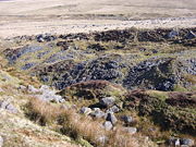
Shafts and adits
There are 25 shaftheadsShaft mining
Shaft mining or shaft sinking refers to the method of excavating a vertical or near-vertical tunnel from the top down, where there is initially no access to the bottom....
visible at Eylesbarrow, most of which are on a single curved alignment along the line of the main lode, which is roughly followed by part of the main track that runs through the mine. The shaftheads exist as conical pits, the smallest being 9m in diameter and the largest, marking Pryce Deacon's Shaft near the eastern end of the alignment, 16m in diameter. Some of them (for instance New Engine Shaft, shown here) have the original masonry collar still visible. Each pit has a spoil heap nearby, usually in the shape of a crescent on the downhill side of the pit. These heaps vary in size; the largest, at Pryce Deacon's Shaft, is over 3m high and covers about 665 square metres. Much interpretative work has taken place to match the visible shafts with the names mentioned in the contemporary documentation, with the result that about half of them can be named and dated with some confidence.
Four adit
Adit
An adit is an entrance to an underground mine which is horizontal or nearly horizontal, by which the mine can be entered, drained of water, and ventilated.-Construction:...
s are referred to in the mine documents. Shallow Adit and Deep Adit both date from the early phase of working, around 1815. Shallow Adit is blocked, its position marked by a stream issuing from the hillside just to the south of the main track. Deep Adit, however, is still open. Its entrance is lined with sturdy granite slabs and is about 2.2m high and 0.9m wide.
Two Brother's Adit is also still open and discharges an abundant stream of water into the steep-sided gulley that surrounds it. It evidently belongs to the later phase of the mine, being first mentioned in the 1840s. The fourth adit, referred to as Deacon's Adit, is untraceable in the field and may never have passed the planning stage.
Leats, reservoir and wheelpits
Despite the extensive underground workings, no more than one waterwheel was used for pumping water out of the mine. The first waterwheel, whose wheelpit can still be seen just to the north of the main track, was built in 1814–15 and was powered by water carried by a leatLeat
A leat is the name, common in the south and west of England and in Wales, for an artificial watercourse or aqueduct dug into the ground, especially one supplying water to a watermill or its mill pond...
that curved around the south side of Higher Hartor Tor drawing water from the upper reaches of the River Plym. In 1818 this leat, known as Engine Leat, was extended over the Plym to also collect water from the Langcombe Brook, a tributary on its south bank. Another leat built in the 1820s attempted to collect water from the hillside to the north. That the water supply was still inadequate at times is shown by the construction, before 1825, of a large linear reservoir on the line of the main leat, the northern end of which is now cut off by the main track which used to pass over it by a bridge. This reservoir was up to 13 m wide and up to 1.3 m deep and its 192 m long dam was about 10 m thick and reinforced with substantial granite blocks on the inner face. William Crossing
William Crossing
William Crossing was a writer and documenter of Dartmoor and Dartmoor life. He lived successively at South Brent, Brentor and at Mary Tavy but died at Plymouth.-Early life:...
reported that the mine owner, a man named Deacon, used to entertain guests by taking them out on the reservoir in a small boat.
Construction of a more powerful waterwheel, the one proposed by Captain Spargo in 1847, was completed by March 1849 at the latest. It replaced the earlier wheel and was sited in the head of the disused Deep Adit Shaft, close to the Two Brothers Adit. This waterwheel had a diameter of 50 ft (15 m) and 3 ft (1 m) breast and was almost certainly the largest on the moor at the time. Being located about 30 m lower down the hillside, it could take advantage of a richer water supply which included the outfall from the nearby adit, an earlier leat drawing water from the Plym, some further leats to the north that attempted to collect water from the surface runoff
Surface runoff
Surface runoff is the water flow that occurs when soil is infiltrated to full capacity and excess water from rain, meltwater, or other sources flows over the land. This is a major component of the water cycle. Runoff that occurs on surfaces before reaching a channel is also called a nonpoint source...
on the hillside, as well as the re-routed Engine Leat.
Traces of all the above-mentioned features can still be seen in the field.
The flatrod system
As a matter of principle a power source (such as a waterwheel) is installed as close as possible to the equipment that it drives (such as a water pump), to minimise the inevitable loss of power incurred in its transmission. When the distance between source and target is significant an efficient means of transferring the power is necessary, and in the 19th century the best method available was the flatrod system. This was used at a number of mines and consisted of a series of linked iron or wooden rods connected to a crankCrank (mechanism)
A crank is an arm attached at right angles to a rotating shaft by which reciprocating motion is imparted to or received from the shaft. It is used to change circular into reciprocating motion, or reciprocating into circular motion. The arm may be a bent portion of the shaft, or a separate arm...
on a waterwheel (or steam engine). The crank converted the circular motion of the wheel into an oscillatory back-and-forth motion of the rods which, suitably supported, could be extended for some distance along the ground. A heavy weight, known as the balance bob, pivoted on one or both ends of the run of the rods kept them under tension and allowed the conversion of the horizontal motion to vertical motion down the shaft.
At Eylesbarrow the engine shafts in which the water pumps were situated were located high on the brow of the hill where there was no adequate water supply for a waterwheel to be located nearby. Consequently the power from the waterwheel was carried by a flatrod system up the hillside to the shafts. The rods were made of iron and were supported by pulleys with flanged rims that ran on short axles supported by pairs of granite pillars around 0.4 m apart. These pillars had distinctive notches cut into their tops to support the axles. Parts of four runs of these paired posts can be seen today. They vary in height from just above ground level to around a metre, and some run through shallow cuttings, representing the varying contour of the ground.
From the wheelpit of the first waterwheel, two series of double pillars head eastwards up the hill, just to the north of the main track. The northern series heads towards Old Engine Shaft, a distance of 663 metres. This shaft was in use from 1814 onwards. The southern, less well preserved series, probably led to Pryce Deacon's Shaft, 777 metres away, and may have been in use in the 1840s.
In the second, later, wheelpit, pictured here, the wheel itself was on the south side of the pit (on the right in this photograph). The short length of wall on the right is the end wall of the wheelpit. The mechanism operating the flatrod system was on the north side, aligned with the short section of wall visible further away on the left: this probably formed part of the first support for the flatrods, which are believed to have travelled underground until they reached a V-shaped gulley, just visible towards the top of the photograph.
This flatrods from this wheel led towards Pryce Deacon's Shaft, 961 metres away and also to Henry's Engine Shaft, 854 metres away. A spur leads off at an angle to another unnamed shaft to the north, 1192 m distant. The chronology of the use of these systems is not certain, though the extension to the northern shaft probably represents the very last phase of underground mining at the site.
Stamping mills and smelting house
The purpose of a stamping mill is to crush the mined ore to a fine sand which is then processed at an adjacent "dressing floor" to separate the heavier tin ore from the waste material or "gangue", which is dumped. There are remains of six stamping mills at Eylesbarrow mine, an unusually high number, although they were not all in use at the same time. They form a rough line down the hillside into the head of the Drizzlecombe valley and in the literature they are numbered from 1 to 6: No. 1 is the highest, located just below the first pumping waterwheel to the north of the main track; No. 6 is about 0.75 km distant and some 35 m lower down the slope. The prominent wall with a hole in it just below the main track is the side wall of the wheelpit of stamping mill No. 2, the hole marking the location of the axle.The oldest mill is No. 4 which was operating in 1804, followed the next year by No. 6., a large construction which had its waterwheel in the centre of the floor with machinery on both sides. Both these were powered by the lower of the two leats that took water from the River Plym. The major works undertaken on the mine in 1814 included the construction of three new mills (Nos. 1, 2 and 3) and the cutting of the higher (Engine) leat to power them.
Mill No. 5, which had the smelter attached, was completed by 1822. The smelting house (shown here as it looks today) had two furnaces. There was a reverberatory furnace
Reverberatory furnace
A reverberatory furnace is a metallurgical or process furnace that isolates the material being processed from contact with the fuel, but not from contact with combustion gases...
—the large squared block in the foreground was part of this; and an older-style blast furnace, similar in design to a blowing house
Blowing House
A blowing house or blowing mill was a building used for smelting tin in Cornwall and on Dartmoor in Devon, in South West England. Blowing houses contained a furnace and a pair of bellows that were powered by an adjacent water wheel, and they were in use from the early 14th century until they were...
, but with a unique flue running up the hillside behind to a short stack. The two large standing and three fallen granite blocks towards the back of the building are the remains of this furnace.
The wheelpit for the waterwheel that powered the bellows of the blast furnace was immediately behind the short length of standing wall, and the small stamping mill and dressing floor were behind again, on the other side of the wheel. The three stone pillars in the background are believed to have supported a roof structure later in the history of the mine, after smelting ceased.
Other remains
Some of the shafts have balance-bob pits associated with them, and there are traces of horse-whims, which were used to raise or lower items in the shafts. Several "reck houses", used for further processing of the crushed ore, are also visible. The ruins of the "mansion" or mine captain's house and its associated buildings can be seen to the north of the main track. There are further remains of an associated mine known as Wheal Katherine about a kilometre to the east—these include six shafts, a wheelpit and another stamping mill (known as No. 7).Sources
- "Search results for "Eylesbarrow"". (Note that according to the grid reference, image da000129 is a photograph of the "Mansion House", not the smelting-house; and da000130 is clearly spurious). Dartmoor Archive. Retrieved on 2009-04-01.