
Extreme points of New Zealand
Encyclopedia
This article discusses the extreme points of New Zealand
: the points that lie farther north, south, east or west than any other equivalent location in the country.
The northernmost point is often thought to be Cape Reinga
, but this is instead the northwesternmost point. Similarly, Bluff
is often considered to be the southernmost point of the South Island, although The Bluff itself (the promontory which gives the town its name) is actually fractionally further north than Slope Point. The phrase "From Cape Reinga to The Bluff" is, however, frequently used within New Zealand to refer to the whole country, ignoring both Slope Point and some offshore islands.
Distance from North to South (Nugent Island to Jacquemart Island) is 2 813 km.
Distance around the four points is 6 176 km.
 (Note: this excludes New Zealand's claims over lands in the Ross Dependency
, and over the Tokelau Islands)
The North Island
The South Island
, although there is a permanently manned station on Raoul Island
much further north. The northernmost settlement of significant size is Te Kao
, and the northernmost town is Kaitaia
. New Zealand's northernmost city is Whangarei
.
, on Stewart Island, although there is a meteorological station on Campbell Island
, though this is no longer permanently manned since 1995. The southernmost town in New Zealand is Bluff
. New Zealand's southernmost city is Invercargill
- also its westernmost city. (Note: New Zealand also has a permanently manned base at Scott Base
in Ross Dependency, this area is not considered part of New Zealand).
on Chatham Island is New Zealand's easternmost settlement. In New Zealand's main chain, the easternmost settlement of any note is Tikitiki
. The town of Ruatoria
is New Zealand's easternmost town. New Zealand's easternmost city is Gisborne
.
and at Manapouri Hydro
are the westernmost settlements in New Zealand. The westernmost settlement of significance is Manapouri
, and the westernmost town is Te Anau
. New Zealand's westernmost city is Invercargill
, which is also its southernmost city.
The shortest distance from New Zealand territory to Australian territory is from Auckland Island
to Macquarie Island
- a distance of approximately 617 km.
New Zealand
New Zealand is an island country in the south-western Pacific Ocean comprising two main landmasses and numerous smaller islands. The country is situated some east of Australia across the Tasman Sea, and roughly south of the Pacific island nations of New Caledonia, Fiji, and Tonga...
: the points that lie farther north, south, east or west than any other equivalent location in the country.
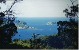
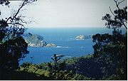
The northernmost point is often thought to be Cape Reinga
Cape Reinga
Cape Reinga is the northwesternmost tip of the Aupouri Peninsula, at the northern end of the North Island of New Zealand. Cape Reinga is located over 100 km north of the nearest small town of Kaitaia. State Highway 1 extends all the way to the Cape, but until 2010 was unsealed gravel road for the...
, but this is instead the northwesternmost point. Similarly, Bluff
Bluff, New Zealand
Bluff is a town and seaport in the Southland region, on the southern coast of the South Island of New Zealand. It is the southern-most town in New Zealand and, despite Slope Point being further to the south, is colloquially used to refer to the southern extremity of the country...
is often considered to be the southernmost point of the South Island, although The Bluff itself (the promontory which gives the town its name) is actually fractionally further north than Slope Point. The phrase "From Cape Reinga to The Bluff" is, however, frequently used within New Zealand to refer to the whole country, ignoring both Slope Point and some offshore islands.
New Zealand overall
- Northernmost point — Nugent IslandNugent IslandNugent Island is the most northerly island in the Kermadec Islands and the most northerly territory in New Zealand. It lies to the northeast of New Zealand. It is circular and approximately across....
, in the Kermadec IslandsKermadec IslandsThe Kermadec Islands are a subtropical island arc in the South Pacific Ocean northeast of New Zealand's North Island, and a similar distance southwest of Tonga... - Southernmost point — Jacquemart IslandJacquemart IslandJacquemart Island, one of the islets surrounding Campbell Island in New Zealand, lies south of Campbell Island and is the southernmost island of New Zealand....
(off the south coast of Campbell Island) in the Campbell Island groupCampbell Island groupThe Campbell Island group is a group of subantarctic islands, belonging to New Zealand. The group has a total area of , consisting of one big island, Campbell Island , and several small islets, notably Dent Island , Isle de Jeanette Marie , Jacquemart Island , and Monowai Island 1... - Westernmost point — Cape LovittCape LovittCape Lovitt is the westernmost point of New Zealand. It is located on the west coast of Auckland Island, one of New Zealand's subantarctic outlying islands, 3 kilometres north of the mouth of Western Arm, a channel leading into Carnley Harbour and separating Auckland Island from Adams Island....
, Auckland IslandsAuckland IslandsThe Auckland Islands are an archipelago of the New Zealand Sub-Antarctic Islands and include Auckland Island, Adams Island, Enderby Island, Disappointment Island, Ewing Island, Rose Island, Dundas Island and Green Island, with a combined area of... - Easternmost point — Forty-Fours/MotuharaForty-Fours/MotuharaForty-Fours/Motuhara is part of the Chatham Islands group, located east of New Zealand's South Island. The islands lie east of the group's main island, Chatham Island. Area Type:* Hypsographic...
, East of the Chatham IslandsChatham IslandsThe Chatham Islands are an archipelago and New Zealand territory in the Pacific Ocean consisting of about ten islands within a radius, the largest of which are Chatham Island and Pitt Island. Their name in the indigenous language, Moriori, means Misty Sun... - The New Zealand’s furthest inland point — S4500.340', E16922.245' 119.44 km from the Tasman Sea and Pacific Ocean.
Distance from North to South (Nugent Island to Jacquemart Island) is 2 813 km.
Distance around the four points is 6 176 km.
Ross Dependency
The Ross Dependency is a region of Antarctica defined by a sector originating at the South Pole, passing along longitudes 160° east to 150° west, and terminating at latitude 60° south...
, and over the Tokelau Islands)
The North IslandNorth IslandThe North Island is one of the two main islands of New Zealand, separated from the much less populous South Island by Cook Strait. The island is in area, making it the world's 14th-largest island...
- Northernmost point — Surville CliffsSurville CliffsThe Surville Cliffs are the northernmost point of the mainland of New Zealand. They are situated on the North Cape of the North Island, 30 kilometres to the east of Cape Reinga , and three kilometres more northerly...
, North CapeNorth Cape, New ZealandNorth Cape is located at the northern end of the North Auckland Peninsula in the North Island of New Zealand . It is the northeastern tip of the Aupouri Peninsula and lies 30 km east of Cape Reinga. The name is sometimes used to refer just to the cape which is known in Māori as Otou and which... - Southernmost point — Cape PalliserCape PalliserCape Palliser is a promontory on the southern coast of New Zealand's North Island and the southernmost point of the North Island - it is in fact considerably further south than Nelson or Blenheim in the South Island....
- Westernmost point — Cape Maria van DiemenCape Maria van DiemenCape Maria van Diemen is the westernmost point of the North Island of New Zealand. Being close to the northern tip of the Aupouri Peninsula, many people in New Zealand also incorrectly believe it to be the northernmost point...
- Easternmost point — East CapeEast CapeEast Cape is the easternmost point of the main islands of New Zealand. It is located to the north of Gisborne in the northeast of the North Island....
The South IslandSouth IslandThe South Island is the larger of the two major islands of New Zealand, the other being the more populous North Island. It is bordered to the north by Cook Strait, to the west by the Tasman Sea, to the south and east by the Pacific Ocean...
- Northernmost point — Cape FarewellCape Farewell, New Zealandthumb|right|Clifftop walk, looking northeast.Cape Farewell is a headland in New Zealand, the most northerly point on the South Island. It is located just west of Farewell Spit...
- Southernmost point — Slope PointSlope PointSlope Point is the southernmost point of the South Island of New Zealand.Slope Point lies just south of the small settlements of Waikawa and Haldane, near the southwestern edge of the Catlins and Toetoes Bay and 70 km east of Invercargill....
- Westernmost point — West Cape
- Easternmost point — West headWest HeadWest Head is the name of three separate headlands on New Zealand's South Island., at the entrance to Okains Bay on Banks Peninsula., at the end of a peninsula on the northern shore of Queen Charlotte Sound., a rocky headland at the entrance to Tory Channel....
Northernmost settlements
The tiny settlement of Kapowairua, at the eastern end of Spirits BaySpirits Bay
Spirits Bay is located at the northern end of the Aupouri Peninsula at the northern tip of New Zealand's North Island. At the western end of the bay is Cape Reinga, from which, according to Māori legend the spirits of the dead leave for their journey to the afterlife .The bay is 12 kilometres in...
, although there is a permanently manned station on Raoul Island
Raoul Island
Anvil-shaped Raoul Island , the largest and northernmost of the main Kermadec Islands, , has been the source of vigorous volcanic activity during the past several thousand years that was dominated by dacitic explosive eruptions.The area of the island, including fringing islets and rocks...
much further north. The northernmost settlement of significant size is Te Kao
Te Kao
Te Kao is a district on the Aupouri Peninsula of Northland, New Zealand. State Highway 1 passes through the district. Cape Reinga is 46 km to the north, and Houhora is 24 km to the south...
, and the northernmost town is Kaitaia
Kaitaia
Kaitaia is a town in the far north region of New Zealand, at the base of the Aupouri Peninsula which is about 160 km northwest of Whangarei. It is the last major settlement on the main road north to the capes and bays on the peninsula...
. New Zealand's northernmost city is Whangarei
Whangarei
Whangarei, pronounced , is the northernmost city in New Zealand and the regional capital of Northland Region. Although commonly classified as a city, it is officially part of the Whangarei District, administered by the Whangarei District Council a local body created in 1989 to administer both the...
.
Southernmost settlements
The southernmost settlement in New Zealand is ObanOban, New Zealand
Oban is the principal settlement on Stewart Island/Rakiura, the southernmost inhabited island of the New Zealand archipelago. Oban is located on Halfmoon Bay , on Paterson Inlet...
, on Stewart Island, although there is a meteorological station on Campbell Island
Campbell Island, New Zealand
Campbell Island is a remote, subantarctic island of New Zealand and the main island of the Campbell Island group. It covers of the group's , and is surrounded by numerous stacks, rocks and islets like Dent Island, Folly Island , Isle de Jeanette Marie, and Jacquemart Island, the latter being the...
, though this is no longer permanently manned since 1995. The southernmost town in New Zealand is Bluff
Bluff, New Zealand
Bluff is a town and seaport in the Southland region, on the southern coast of the South Island of New Zealand. It is the southern-most town in New Zealand and, despite Slope Point being further to the south, is colloquially used to refer to the southern extremity of the country...
. New Zealand's southernmost city is Invercargill
Invercargill
Invercargill is the southernmost and westernmost city in New Zealand, and one of the southernmost cities in the world. It is the commercial centre of the Southland region. It lies in the heart of the wide expanse of the Southland Plains on the Oreti or New River some 18 km north of Bluff,...
- also its westernmost city. (Note: New Zealand also has a permanently manned base at Scott Base
Scott Base
Scott Base is a research facility located in Antarctica and is operated by New Zealand. It was named after Captain Robert Falcon Scott, Royal Navy, leader of two British expeditions to the Ross Sea area of Antarctica...
in Ross Dependency, this area is not considered part of New Zealand).
Easternmost settlements
The settlement of WaitangiWaitangi, Chatham Islands
Waitangi is the main port and settlement on the Chatham Islands. It is located on the southern shore of Petre Bay, on the west coast of the main island...
on Chatham Island is New Zealand's easternmost settlement. In New Zealand's main chain, the easternmost settlement of any note is Tikitiki
Tikitiki
Tikitiki, formerly known as Kahukura, is a small township close to the estuary of the Waiapu River, 150 kilometres north of Gisborne in northeastern New Zealand. State Highway 35 passes through it, and the settlement is the easternmost point on the New Zealand highway network....
. The town of Ruatoria
Ruatoria
The town of Ruatoria is located in the East Coast region of New Zealand's North Island. It is the second largest centre of population in the sparsely populated region, yet has a population of only 900 .- Geography :...
is New Zealand's easternmost town. New Zealand's easternmost city is Gisborne
Gisborne, New Zealand
-Economy:The harbour was host to many ships in the past and had developed as a river port to provide a more secure location for shipping compared with the open roadstead of Poverty Bay which can be exposed to southerly swells. A meat works was sited beside the harbour and meat and wool was shipped...
.
Westernmost settlements
Small settlements at the head of Doubtful SoundDoubtful Sound
Doubtful Sound is a very large and naturally imposing fjord in Fiordland, in the far south west of New Zealand. It is located in the same region as the smaller but more famous and accessible Milford Sound...
and at Manapouri Hydro
Manapouri Power Station
Manapouri Power Station is an underground hydroelectric power station on the western arm of Lake Manapouri in Fiordland National Park, in the South Island of New Zealand...
are the westernmost settlements in New Zealand. The westernmost settlement of significance is Manapouri
Manapouri
Manapouri is a small town in Southland / Fiordland, in the southwest corner of the South Island, in New Zealand. Located at the edge of the Fiordland National Park, on the eastern shore of Lake Manapouri, close to its outflow into the Waiau River, tourist boat services are based in the...
, and the westernmost town is Te Anau
Te Anau
Te Anau is a town in the South Island of New Zealand. It is on the eastern shore of Lake Te Anau in Fiordland. Lake Te Anau is the largest lake in the South Island and second only within New Zealand to Lake Taupo. The 2001 census recorded the town's population as 1,857...
. New Zealand's westernmost city is Invercargill
Invercargill
Invercargill is the southernmost and westernmost city in New Zealand, and one of the southernmost cities in the world. It is the commercial centre of the Southland region. It lies in the heart of the wide expanse of the Southland Plains on the Oreti or New River some 18 km north of Bluff,...
, which is also its southernmost city.
Closest point to Australia
The closest point to mainland Australia and Tasmania is near the Resolution Island lighthouse at 45°44′S, 166°28′E (Fiordland), a distance of approximately 1 491 km from a point near Tasman Island lighthouse 43°12′S, 148°E (Tasmania).The shortest distance from New Zealand territory to Australian territory is from Auckland Island
Auckland Island
Auckland Island is the main island of the Auckland Islands, an uninhabited archipelago in the south Pacific Ocean belonging to New Zealand. It is inscribed in the together with the other subantarctic New Zealand islands in the region as follows: 877-004 Auckland Isls, New Zealand S50.29 E165.52...
to Macquarie Island
Macquarie Island
Macquarie Island lies in the southwest corner of the Pacific Ocean, about half-way between New Zealand and Antarctica, at 54°30S, 158°57E. Politically, it has formed part of the Australian state of Tasmania since 1900 and became a Tasmanian State Reserve in 1978. In 1997 it became a world heritage...
- a distance of approximately 617 km.
See also
- Geography of New ZealandGeography of New ZealandThe geography of New Zealand encompasses two main islands and a number of smaller islands, located near the centre of the water hemisphere. New Zealand varies in climate, from cold and wet to dry and to subtropical in some areas...
- Extreme points of Earth