
Macquarie Island
Encyclopedia
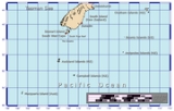
Pacific Ocean
The Pacific Ocean is the largest of the Earth's oceanic divisions. It extends from the Arctic in the north to the Southern Ocean in the south, bounded by Asia and Australia in the west, and the Americas in the east.At 165.2 million square kilometres in area, this largest division of the World...
, about half-way between New Zealand
New Zealand
New Zealand is an island country in the south-western Pacific Ocean comprising two main landmasses and numerous smaller islands. The country is situated some east of Australia across the Tasman Sea, and roughly south of the Pacific island nations of New Caledonia, Fiji, and Tonga...
and Antarctica, at 54°30S, 158°57E. Politically, it has formed part of the Australian state of Tasmania
Tasmania
Tasmania is an Australian island and state. It is south of the continent, separated by Bass Strait. The state includes the island of Tasmania—the 26th largest island in the world—and the surrounding islands. The state has a population of 507,626 , of whom almost half reside in the greater Hobart...
since 1900 and became a Tasmanian State Reserve
Protected areas of Tasmania
-Conservation areas:*Adamsfield*Alpha Pinnacle*Ansons Bay*Arthur-Pieman*Asbestos Range*Badger Corner*Bay Of Fires*Bernafai Ridge*Boltons Beach*Bouchers Creek*Briggs Islet*Brougham Sugerloaf*Burnie Fernglade*Calverts Lagoon*Cape Portland*Cat Island...
in 1978. In 1997 it became a world heritage site
World Heritage Site
A UNESCO World Heritage Site is a place that is listed by the UNESCO as of special cultural or physical significance...
. It was a part of Esperance Municipality until 1993, when the municipality was merged with other municipalities to Huon Valley
Huon Valley
The Huon Valley Council is a Local Government Area of Tasmania. It is the southern-most local government area in Australia.It encompasses the town of Huonville, on the Huon River, some surrounding towns, and many protected areas and forestry plantations...
. Ecologically, it is part of the Antipodes Subantarctic Islands tundra
Antipodes Subantarctic Islands tundra
The Antipodes Subantarctic Islands tundra ecoregion, within the Tundra Biome, includes five remote island groups in the Southern Ocean south of New Zealand: the Bounty Islands, Auckland Islands, Antipodes Islands and Campbell Island groups of New Zealand, and Macquarie Island of Australia.-Location...
ecoregion
Ecoregion
An ecoregion , sometimes called a bioregion, is an ecologically and geographically defined area that is smaller than an ecozone and larger than an ecosystem. Ecoregions cover relatively large areas of land or water, and contain characteristic, geographically distinct assemblages of natural...
.
Since 1948 the Australian Antarctic Division
Australian Antarctic Division
The Australian Antarctic Division is an agency of the Department of Sustainability, Environment, Water, Population and Communities . The division undertakes science programs and research projects to contribute to an understanding of Antarctica and the Southern Ocean...
(AAD) has maintained a permanent base, the Macquarie Island Station
Macquarie Island Station
Macquarie Island Station, known as Macca to staff, is a permanent Australian subantarctic research base on Macquarie Island, lying about half-way between Australia and Antarctica...
, on the isthmus at the northern end of the island at the foot of Wireless Hill
Wireless Hill
Wireless Hill is a steep-sided hill with a summit plateau that takes up most of the North Head promontory at the northern end of Australia’s subantarctic Macquarie Island, lying in the Southern Ocean about halfway between Australia and Antarctica...
. The population of the base, the island's only human inhabitants, usually varies from 20 to 40 people over the year.
History
The AustraliaAustralia
Australia , officially the Commonwealth of Australia, is a country in the Southern Hemisphere comprising the mainland of the Australian continent, the island of Tasmania, and numerous smaller islands in the Indian and Pacific Oceans. It is the world's sixth-largest country by total area...
n/Briton
United Kingdom
The United Kingdom of Great Britain and Northern IrelandIn the United Kingdom and Dependencies, other languages have been officially recognised as legitimate autochthonous languages under the European Charter for Regional or Minority Languages...
Frederick Hasselborough
Frederick Hasselborough
Frederick Hasselborough polar explorer , whose surname is also spelled Hasselburgh and Hasselburg, was an Australian sealer from Sydney who discovered Campbell and Macquarie Islands .-References:...
discovered the island accidentally in July 1810 when looking for new sealing
Seal hunting
Seal hunting, or sealing, is the personal or commercial hunting of seals. The hunt is currently practiced in five countries: Canada, where most of the world's seal hunting takes place, Namibia, the Danish region of Greenland, Norway and Russia...
grounds. He claimed Macquarie Island for Britain
United Kingdom
The United Kingdom of Great Britain and Northern IrelandIn the United Kingdom and Dependencies, other languages have been officially recognised as legitimate autochthonous languages under the European Charter for Regional or Minority Languages...
and annexed it to the colony of New South Wales
New South Wales
New South Wales is a state of :Australia, located in the east of the country. It is bordered by Queensland, Victoria and South Australia to the north, south and west respectively. To the east, the state is bordered by the Tasman Sea, which forms part of the Pacific Ocean. New South Wales...
in 1810. The island took its name after Colonel Lachlan Macquarie
Lachlan Macquarie
Major-General Lachlan Macquarie CB , was a British military officer and colonial administrator. He served as the last autocratic Governor of New South Wales, Australia from 1810 to 1821 and had a leading role in the social, economic and architectural development of the colony...
, Governor of New South Wales from 1810 to 1821. Fabian Gottlieb von Bellingshausen
Fabian Gottlieb von Bellingshausen
Fabian Gottlieb Thaddeus von Bellingshausen was an officer in the Imperial Russian Navy, cartographer and explorer, who ultimately rose to the rank of Admiral...
, who explored the area for Alexander I of Russia
Alexander I of Russia
Alexander I of Russia , served as Emperor of Russia from 23 March 1801 to 1 December 1825 and the first Russian King of Poland from 1815 to 1825. He was also the first Russian Grand Duke of Finland and Lithuania....
, produced the first map of Macquarie Island. Bellingshausen landed on the island on 28 November 1820, defined its geographical position and traded his rum
Rum
Rum is a distilled alcoholic beverage made from sugarcane by-products such as molasses, or directly from sugarcane juice, by a process of fermentation and distillation. The distillate, a clear liquid, is then usually aged in oak barrels...
and food for Macquarie Island's fauna
Fauna
Fauna or faunæ is all of the animal life of any particular region or time. The corresponding term for plants is flora.Zoologists and paleontologists use fauna to refer to a typical collection of animals found in a specific time or place, e.g. the "Sonoran Desert fauna" or the "Burgess shale fauna"...
with the sealers
Seal hunting
Seal hunting, or sealing, is the personal or commercial hunting of seals. The hunt is currently practiced in five countries: Canada, where most of the world's seal hunting takes place, Namibia, the Danish region of Greenland, Norway and Russia...
. Between 1810 to 1919, seals and then penguins were hunted almost to the point of extinction.
In 1890, New South Wales transferred the island to Tasmania
Tasmania
Tasmania is an Australian island and state. It is south of the continent, separated by Bass Strait. The state includes the island of Tasmania—the 26th largest island in the world—and the surrounding islands. The state has a population of 507,626 , of whom almost half reside in the greater Hobart...
, which leased it to Joseph Hatch
Joseph Hatch
Joseph Hatch was a New Zealand politician, but is now remembered for harvesting penguins and elephant seals for their oil on the sub-Antarctic Macquarie Island from 1890 to 1919. About two million penguins were killed over nearly three decades. His company J...
(1837–1928) between 1902 and 1920 for his oil industry based on harvesting penguins.
Between 1911 and 1914, the island became a base for the Australasian Antarctic Expedition
Australasian Antarctic Expedition
The Australasian Antarctic Expedition was an Australasian scientific team that explored part of Antarctica between 1911 and 1914. It was led by the Australian geologist Douglas Mawson, who was knighted for his achievements in leading the expedition. In 1910 he began to plan an expedition to chart...
under Sir Douglas Mawson
Douglas Mawson
Sir Douglas Mawson, OBE, FRS, FAA was an Australian geologist, Antarctic explorer and Academic. Along with Roald Amundsen, Robert Falcon Scott, and Ernest Shackleton, Mawson was a key expedition leader during the Heroic Age of Antarctic Exploration.-Early work:He was appointed geologist to an...
. George Ainsworth
George Ainsworth
George Frederick Ainsworth was an Australian meteorologist, public servant and businessman who headed one of the component parts of Douglas Mawson’s Australasian Antarctic Expedition .-Early years:...
operated a meteorological
Meteorology
Meteorology is the interdisciplinary scientific study of the atmosphere. Studies in the field stretch back millennia, though significant progress in meteorology did not occur until the 18th century. The 19th century saw breakthroughs occur after observing networks developed across several countries...
station between 1911 and 1913, followed by Harold Power (1913 to 1914) and by Arthur Tulloch from 1914 until its shutdown in 1915. In 1933, the authorities declared the island a wildlife sanctuary under the Tasmanian Animals and Birds Protection Act 1928 and in 1972 it was made a State Reserve under the Tasmanian National Parks and Wildlife Act 1970. The Australian National Antarctic Research Expeditions
Australian National Antarctic Research Expeditions
The Australian National Antarctic Research Expeditions is the historical name for the Australian Antarctic Program administered for Australia by the Australian Antarctic Division .-The ANARE Name:...
(ANARE) established its expedition headquarters on 25 May 1948 on Macquarie Island.
On 5 December 1997, Macquarie Island was listed as a World Heritage Site
World Heritage Site
A UNESCO World Heritage Site is a place that is listed by the UNESCO as of special cultural or physical significance...
mainly because of its unique geological values.
On 23 December 2004, an earthquake measuring 8.1 on the Richter magnitude scale
Richter magnitude scale
The expression Richter magnitude scale refers to a number of ways to assign a single number to quantify the energy contained in an earthquake....
(one of the largest earthquakes ever recorded) rocked the island, but caused little damage.
On 12 April 2008, a 7.1 earthquake on the Macquarie Fault
Macquarie Fault Zone
The Macquarie Fault Zone is a major right lateral-moving transform fault along the seafloor of the south Pacific Ocean which runs from New Zealand southwestward to the Macquarie Triple Junction...
occurred near Macquarie Island.
Geography
Macquarie Island is an exposed portion of the Macquarie Ridge, and is located where the Australian plateAustralia (continent)
Australia is the world's smallest continent, comprising the mainland of Australia and proximate islands including Tasmania, New Guinea, the Aru Islands and Raja Ampat Islands...
meets the Pacific plate
Pacific Plate
The Pacific Plate is an oceanic tectonic plate that lies beneath the Pacific Ocean. At 103 million square kilometres, it is the largest tectonic plate....
. It is the only place in the world where rocks from the mantle are actively exposed at sea level. Due to this it was made a UNESCO
UNESCO
The United Nations Educational, Scientific and Cultural Organization is a specialized agency of the United Nations...
world heritage site in 1997.
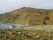
The island has an approximate length of 34 km (21 mi) and a width of 5 km (3 mi), with an area of 128 km² (49 sq mi). Near Macquarie Island are two small groups of minor islands, the Judge and Clerk Islets
Judge and Clerk Islets
The Judge and Clerk Islets are small islands, with a total land and reef area of no more than , lying north of Macquarie Island in the Southern Ocean. They are, with Macquarie Island, part of Tasmania, Australia. They are in the Macquarie Island Nature Reserve and World Heritage Area, and form a...
, 54°21′S 159°01′E, 14 km (9 mi) to the north, and 0.2 km² (49.4 acre) in area, and the Bishop and Clerk Islets
Bishop and Clerk Islets
The Bishop and Clerk Islets lie approximately to the south of Macquarie Island. They are in area. The Bishop and Clerk Islets mark the southernmost point of Australia . These islets are mostly barren rock less than high and are geologically similar to Macquarie Island.Macquarie Shags have...
, 55°03′S 158°46′E, 34 km (21.1 mi) to the south, and 0.6 km² (148.3 acre) in area.
The island is in two main pieces of plateau of around 150–200 m (492.1–656.2 ft) elevation to the north and south, joined by a narrow isthmus close to sea level. The high points include Mount Elder on the north-east coastal ridge at 385 m (1,263.1 ft), and Mounts Hamilton and Fletcher in the south at 410 m (1,345.1 ft).
Macquarie Island lies atop a geographic feature named for the island, the Macquarie Ridge. This seafloor ridge is aligned along the eastern margin of the tectonic
Tectonics
Tectonics is a field of study within geology concerned generally with the structures within the lithosphere of the Earth and particularly with the forces and movements that have operated in a region to create these structures.Tectonics is concerned with the orogenies and tectonic development of...
plate boundary between the Indo-Australian Plate
Indo-Australian Plate
The Indo-Australian Plate is a major tectonic plate that includes the continent of Australia and surrounding ocean, and extends northwest to include the Indian subcontinent and adjacent waters...
and the Pacific Plate
Pacific Plate
The Pacific Plate is an oceanic tectonic plate that lies beneath the Pacific Ocean. At 103 million square kilometres, it is the largest tectonic plate....
. The Bishop and Clerk Islets mark the southernmost point of Australia
Extreme points of Australia
-Australia :* Northernmost Point – Cape York, Queensland * Southernmost Point – South Point, Wilsons Promontory, Victoria * South-westernmost Point - Cape Leeuwin, Western Australia -Australia (mainland):* Northernmost Point – Cape York, Queensland (10°41' S)* Southernmost Point – South Point,...
(including islands). In the 19th Century the phantom Emerald Island
Emerald Island (phantom)
The Emerald Island is a phantom island reported to lie between Australia and Antarctica and south of Macquarie Island. It was first sighted by the British sealing ship Emerald, captained by William Elliot, in December 1821, and the name of the presumed island derives from the name of this ship...
supposedly lay to the south of Macquarie Island.
Climate
Macquarie Island's climate is moderated by the sea, and all months have an average temperature above freezing, although snow is common between June and October and may even occur in Macquarie Island's "summer".Average daily temperatures range from 4.9 °C (40.8 °F) in July to 8.8 °C (47.8 °F) in January. Precipitation occurs fairly evenly throughout the year and averages 967.9 mm (38.1 in) annually. Macquarie Island is one of the gloomiest places on Earth with an average of only 856 hours of sunshine per year; Tórshavn
Tórshavn
Tórshavn is the capital and largest town of the Faroe Islands. It is located in the southern part on the east coast of Streymoy. To the north west of the town lies the high mountain Húsareyn, and to the southwest, the high Kirkjubøreyn...
in the Faroe Islands
Faroe Islands
The Faroe Islands are an island group situated between the Norwegian Sea and the North Atlantic Ocean, approximately halfway between Scotland and Iceland. The Faroe Islands are a self-governing territory within the Kingdom of Denmark, along with Denmark proper and Greenland...
is its nearest rival among places with recorded sunshine data with 884 hours per year, though absolutely no data exist for many places notorious for gloom like southern Chile
Zona Austral
The Zona Austral is one of the five natural regions into which CORFO divided continental Chile in 1950 corresponding to the Chilean portion of Patagonia. It is surrounded by the Southern Zone and the Chacao Channel to the north, the Pacific Ocean and Drake's Passage to the south and west, and the...
and the Aleutian Islands.
Flora and fauna

The flora has taxonomic affinities with other subantarctic islands, especially those to the south of New Zealand. Plants rarely grow over 1 m in height, though the tussock-forming grass Poa foliosa
Poa foliosa
Poa foliosa is a species of tussock grass commonly known as Muttonbird Poa. It is native to the subantarctic islands of New Zealand and Australia.-Description:...
can grow up to 2 m tall in sheltered areas. There are over 45 vascular plant
Vascular plant
Vascular plants are those plants that have lignified tissues for conducting water, minerals, and photosynthetic products through the plant. Vascular plants include the clubmosses, Equisetum, ferns, gymnosperms and angiosperms...
species and more than 90 moss species, as well as many liverworts
Marchantiophyta
The Marchantiophyta are a division of bryophyte plants commonly referred to as hepatics or liverworts. Like other bryophytes, they have a gametophyte-dominant life cycle, in which cells of the plant carry only a single set of genetic information....
and lichen
Lichen
Lichens are composite organisms consisting of a symbiotic organism composed of a fungus with a photosynthetic partner , usually either a green alga or cyanobacterium...
s. Woody plants are absent. The island has five principal vegetation formations: grassland
Grassland
Grasslands are areas where the vegetation is dominated by grasses and other herbaceous plants . However, sedge and rush families can also be found. Grasslands occur naturally on all continents except Antarctica...
, herbfield
Herbfield
Herbfields are plant communities dominated by herbaceous plants, especially forbs and grasses. They are found where climatic conditions do not allow large woody plants to grow, such as in subantarctic and alpine tundra environments...
, fen
Fen
A fen is a type of wetland fed by mineral-rich surface water or groundwater. Fens are characterised by their water chemistry, which is neutral or alkaline, with relatively high dissolved mineral levels but few other plant nutrients...
, bog
Bog
A bog, quagmire or mire is a wetland that accumulates acidic peat, a deposit of dead plant material—often mosses or, in Arctic climates, lichens....
and feldmark
Feldmark
Feldmark, also spelt fjaeldmark , is a plant community characteristic of sites where plant growth is severely restricted by extremes of cold and by exposure to wind, typical of alpine tundra and subantarctic environments.-Description:...
. Bog communities include 'featherbed', a deep and spongy peat
Peat
Peat is an accumulation of partially decayed vegetation matter or histosol. Peat forms in wetland bogs, moors, muskegs, pocosins, mires, and peat swamp forests. Peat is harvested as an important source of fuel in certain parts of the world...
bog
Bog
A bog, quagmire or mire is a wetland that accumulates acidic peat, a deposit of dead plant material—often mosses or, in Arctic climates, lichens....
vegetated by grasses and low herbs, with patches of free water. Endemic flora include the cushion plant
Cushion plant
A cushion plant is a compact, low growing, mat forming plant that is found in alpine, subalpine, arctic, or subarctic environments around the world...
Azorella macquariensis
Azorella macquariensis
Azorella macquariensis, also known as Macquarie Azorella or Macquarie Cushions, is a species of cushion plant endemic to Australia’s subantarctic Macquarie Island. It was referred to the more widely distributed A. selago until 1989, when it was described as a separate species.-Description:Azorella...
, the grass
Grass
Grasses, or more technically graminoids, are monocotyledonous, usually herbaceous plants with narrow leaves growing from the base. They include the "true grasses", of the Poaceae family, as well as the sedges and the rushes . The true grasses include cereals, bamboo and the grasses of lawns ...
Puccinellia macquariensis
Puccinellia macquariensis
Puccinellia macquariensis is a species of salt-tolerant, perennial, tufted grass in the Poaceae family. It is endemic to Australia’s subantarctic Macquarie Island in the Southern Ocean, though very closely related to P. chathamica of New Zealand’s southern offshore islands...
, as well as two orchids - Nematoceras dienemum
Nematoceras dienemum
Nematoceras dienemum , also known as the Windswept Helmet-orchid, is one of two helmet orchids endemic to Australia’s subantarctic Macquarie Island, and the first orchid to be found there...
and Nematoceras sulcatum
Nematoceras sulcatum
Nematoceras sulcatum, also known as the Grooved Helmet-orchid, is one of two helmet orchids endemic to Australia’s subantarctic Macquarie Island, and the second to be discovered. The specific epithet comes from the Latin sulcatus – “grooved”, with reference to the prominent groove in the labellum...
.
Fauna found on the island include: Subantarctic Fur Seal
Subantarctic Fur Seal
The subantarctic fur seal is a fur seal found in the southern parts of the Indian and Atlantic Oceans. It was first described by Gray in 1872 from a specimen recovered in northern Australia—hence the inappropriate tropicalis specific name.- Description :The subantarctic fur seal is...
s, Antarctic Fur Seal
Antarctic Fur Seal
The Antarctic fur seal is one of eight seals in the genus Arctocephalus, and one of nine fur seals in the subfamily Arctocephalinae. As its name suggests, the Antarctic fur seal is distributed in Antarctic waters. Around 95% of the world population breeds at the Island of South Georgia...
s, New Zealand Fur Seal
New Zealand Fur Seal
The Australian fur seal , or New Zealand fur seal or southern fur seal, is a species of fur seal found around the south coast of Australia, the coast of the South Island of New Zealand, and some of the small islands to the south and east of there...
s and Southern Elephant Seal
Southern Elephant Seal
The Southern Elephant Seal is one of the two extant species of elephant seal. It is both the most massive pinniped and member of the order Carnivora living today...
s - over 80,000 individuals of this species. Royal Penguin
Royal Penguin
The Royal Penguin inhabits the waters surrounding Antarctica. Royals look very much like Macaroni Penguins, but have a white face and chin instead of the Macaronis' black visage. They are long and weigh . Males are larger than females...
s and Macquarie Shag
Macquarie Shag
The Macquarie Shag , Macquarie Island Shag or Macquarie Island Cormorant, is a marine cormorant native to Macquarie Island in the Southern Ocean, about halfway between Australia and Antarctica....
s are endemic breeders, while King Penguin
King Penguin
The King Penguin is the second largest species of penguin at about , second only to the Emperor Penguin. There are two subspecies—A. p. patagonicus and A. p...
s, Southern Rockhopper Penguin
Southern Rockhopper Penguin
The Southern Rockhopper Penguin group , are two subspecies of rockhopper penguin, that together are sometimes considered distinct from the Northern Rockhopper Penguin...
s and Gentoo Penguin
Gentoo penguin
The Gentoo Penguin , Pygoscelis papua, is easily recognized by the wide white stripe extending like a bonnet across the top of its head and its bright orange-red bill. The gentoo penguin has pale whitish-pink webbed feet and a fairly long tail - the most prominent tail of all penguins. Chicks have...
s also breed here in large numbers.
Ecological balance
The ecology of the island was affected soon after the beginning of European visits to the island in 1810. The island's fur sealFur seal
Fur seals are any of nine species of pinnipeds in the Otariidae family. One species, the northern fur seal inhabits the North Pacific, while seven species in the Arctocephalus genus are found primarily in the Southern hemisphere...
s, elephant seal
Elephant seal
Elephant seals are large, oceangoing seals in the genus Mirounga. There are two species: the northern elephant seal and the southern elephant seal . Both were hunted to the brink of extinction by the end of the 19th century, but numbers have since recovered...
s and penguin
Penguin
Penguins are a group of aquatic, flightless birds living almost exclusively in the southern hemisphere, especially in Antarctica. Highly adapted for life in the water, penguins have countershaded dark and white plumage, and their wings have become flippers...
s were killed for fur and blubber. Rats and mice that were inadvertently introduced from the ships prospered due to lack of predators. Cats were subsequently introduced deliberately to keep the rodents from eating human food stores. In about 1870, rabbits were left on the island by sealers to breed for food. By the 1970s, the then 130,000 rabbits were causing tremendous damage to vegetation.
The feral cat
Feral cat
A feral cat is a descendant of a domesticated cat that has returned to the wild. It is distinguished from a stray cat, which is a pet cat that has been lost or abandoned, while feral cats are born in the wild; the offspring of a stray cat can be considered feral if born in the wild.In many parts of...
s introduced to the island have had a devastating effect on the native seabird population, with an estimated 60,000 seabird deaths per year. From 1985, efforts were undertaken to remove the cats. In June 2000, the last of the nearly 2500 cats were culled in an effort to save the seabirds. Seabird populations responded rapidly, but rat
Rat
Rats are various medium-sized, long-tailed rodents of the superfamily Muroidea. "True rats" are members of the genus Rattus, the most important of which to humans are the black rat, Rattus rattus, and the brown rat, Rattus norvegicus...
s and rabbit
Rabbit
Rabbits are small mammals in the family Leporidae of the order Lagomorpha, found in several parts of the world...
s continued to cause widespread environmental damage.
The rabbits rapidly multiplied before numbers were reduced to about 10,000 in the early 1980s when myxomatosis
Myxomatosis
Myxomatosis is a disease that affects rabbits and is caused by the Myxoma virus. It was first observed in Uruguay in laboratory rabbits in the late 19th century. It was introduced into Australia in 1950 in an attempt to control the rabbit population...
was introduced. Rabbit numbers have grown again to around 100,000 on the island. The rodents feed on young chicks while rabbits nibbling on the grass layer has led to soil erosion and cliff collapses, destroying seabird nests. Large portions of the Macquarie Island bluffs are eroding as a result. In September 2006 a large landslip at Lusitania Bay, on the eastern side of the island, partially destroyed an important penguin breeding colony. Tasmania Parks and Wildlife Service
Tasmania Parks and Wildlife Service
Tasmania Parks and Wildlife Service is the Tasmanian Government body responsible for the care and administration of Tasmania's National Parks and wildlife.-History:...
attributed the landslip to a combination of heavy spring rains and severe erosion caused by rabbits.
Research by Australian Antarctic Division
Australian Antarctic Division
The Australian Antarctic Division is an agency of the Department of Sustainability, Environment, Water, Population and Communities . The division undertakes science programs and research projects to contribute to an understanding of Antarctica and the Southern Ocean...
scientists, published in the 13 January 2009 edition of the British Ecological Society
British Ecological Society
The British Ecological Society is a learned society in the field of ecology that was founded in 1913. It was the first ecological society in the world. The society's original objective was "to promote and foster the study of Ecology in its widest sense" and this remains the central theme guiding...
's Journal of Applied Ecology, suggested that the success of the feral cat eradication program has allowed the rabbit population to increase, damaging the Macquarie Island ecosystem by altering significant areas of island vegetation. In a later issue of the same journal however, other scientists argued that a number of factors were almost certainly involved and the absence of cats may have been relatively minor among them.
On 4 June 2007 a media release by the Australian Federal Minister for the Environment and Water Resources, Malcolm Turnbull
Malcolm Turnbull
Malcolm Bligh Turnbull is an Australian politician. He has been a member of the Australian House of Representatives since 2004, and was Leader of the Opposition and parliamentary leader of the Liberal Party from 16 September 2008 to 1 December 2009.Turnbull has represented the Division...
, announced that the Australian and Tasmanian Governments had reached an agreement to jointly fund the eradication of rodent pests, including rabbits, to protect Macquarie Island's World Heritage values. The plan, estimated to cost $24 million Australian dollar
Australian dollar
The Australian dollar is the currency of the Commonwealth of Australia, including Christmas Island, Cocos Islands, and Norfolk Island, as well as the independent Pacific Island states of Kiribati, Nauru and Tuvalu...
s, will involve mass baiting the island similar to an eradication program on New Zealand
New Zealand
New Zealand is an island country in the south-western Pacific Ocean comprising two main landmasses and numerous smaller islands. The country is situated some east of Australia across the Tasman Sea, and roughly south of the Pacific island nations of New Caledonia, Fiji, and Tonga...
's Campbell Island
Campbell Island, New Zealand
Campbell Island is a remote, subantarctic island of New Zealand and the main island of the Campbell Island group. It covers of the group's , and is surrounded by numerous stacks, rocks and islets like Dent Island, Folly Island , Isle de Jeanette Marie, and Jacquemart Island, the latter being the...
, which will be followed up with dog hunting teams trained by Steve Austin
Steve Austin (dog trainer)
Steve Austin is an Australian dog trainer, who has been training dogs for over 25 years. He is renown as one of Australia's top animal trainers, with a particular skill in dog behaviour and training. His lifetime in dog training has seen him train animals for quarantine, search and rescue, police...
and is expected to take up to seven years.
See also
- List of administrative heads of Macquarie Island
- List of islands of Australia
- List of sub-antarctic islands
- Island restorationIsland restorationThe ecological restoration of islands, or island restoration, is the application of the principles of ecological restoration to islands and island groups. Islands, due to their isolation, are home to many of the world's endemic species, as well as important breeding grounds for seabirds and some...