
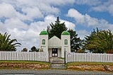
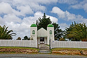
Te Kao
Encyclopedia
Te Kao is a district on the Aupouri Peninsula
of Northland, New Zealand
. State Highway 1
passes through the district. Cape Reinga
is 46 km to the north, and Houhora
is 24 km to the south. The Aupouri Forest and Ninety Mile Beach
are to the west.
The Te Aupōuri
athlete Te Houtaewa started his legendary run along Ninety Mile Beach at Te Kao.
of 2 and a roll of 24. The school celebrated its 125th anniversary on Labour Weekend, 2006.
Aupouri Peninsula
The Aupouri Peninsula is a tombolo at the northern tip of the North Island of New Zealand. It projects between the Tasman Sea to the west and the Pacific Ocean to the east...
of Northland, New Zealand
New Zealand
New Zealand is an island country in the south-western Pacific Ocean comprising two main landmasses and numerous smaller islands. The country is situated some east of Australia across the Tasman Sea, and roughly south of the Pacific island nations of New Caledonia, Fiji, and Tonga...
. State Highway 1
State Highway 1 (New Zealand)
State Highway 1 is the longest and most significant road in the New Zealand roading network, running the length of both main islands. It appears on road maps as SH 1 and on road signs as a white number 1 on a red shield, but it has the official designations SH 1N in the North Island, SH 1S in the...
passes through the district. Cape Reinga
Cape Reinga
Cape Reinga is the northwesternmost tip of the Aupouri Peninsula, at the northern end of the North Island of New Zealand. Cape Reinga is located over 100 km north of the nearest small town of Kaitaia. State Highway 1 extends all the way to the Cape, but until 2010 was unsealed gravel road for the...
is 46 km to the north, and Houhora
Houhora
Houhora is a locality and harbour on the east side of the Aupouri Peninsula of Northland, New Zealand. It is north of Kaitaia. Waihopo, Te Raupo, Pukenui, Raio and Houhora Heads are associated localities on the southern shores of the harbour. State Highway 1 passes through all these localities...
is 24 km to the south. The Aupouri Forest and Ninety Mile Beach
Ninety Mile Beach, New Zealand
Ninety Mile Beach is a beach located on the western coast of the far north of the North Island of New Zealand. It stretches from just west of Kaitaia towards Cape Reinga along the Aupouri Peninsula. It begins close to the headland of Reef Point, to the west of Ahipara Bay, sweeping briefly...
are to the west.
The Te Aupōuri
Te Aupouri
Te Aupōuri is the northernmost Māori iwi , located north of Kaitaia, Northland, New Zealand, a region known as the Aupouri Peninsula.-The ancestral legend:...
athlete Te Houtaewa started his legendary run along Ninety Mile Beach at Te Kao.
Education
Te Kao School is a coeducational full primary (years 1-8) school with a decile ratingSocio-Economic Decile
Decile, Socio-Economic Decile or Socio-Economic Decile Band is a widely used measure in education in New Zealand used to target funding and support to more needy schools....
of 2 and a roll of 24. The school celebrated its 125th anniversary on Labour Weekend, 2006.