
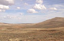
Emigrant Trail in Wyoming
Encyclopedia
The path followed by the Oregon Trail
, California Trail
and Mormon Trail
(collectively referred to as the Emigrant Trail
) spans 400 miles (643.7 km) through the U.S. state
of Wyoming
. The trail enters from Nebraska
on the eastern border of the state near the present day town of Torrington
and exited on the western border near the towns of Cokeville
and Afton
. An estimated 350,000 to 400,000 settlers traveled on the trail through Wyoming between 1841 and 1868. All three trails follow the same path through most of the state. The Mormon Trail splits at Fort Bridger
and enters Utah
, while the Oregon and California Trails continue to Idaho
.
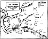
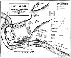 In the eastern plains, the Emigrant Trail follows the North Platte River
into Wyoming. The trail follows the river upstream to Fort Laramie, a prominent military and trading post in the region. Prior to 1850 the northern side of the river was thought to be impassable beyond Fort Laramie, so the wagon trains that were traveling on the northern side of the river through Nebraska had to undertake a dangerous crossing at the fort. After crossing, trains on the main trail to the south of the river had to cross the North Platte again 100 miles (160.9 km) upstream. In 1850 several wagon trains successfully blazed a path along the northern side of the river. This new route, which reduced the risk and expense of crossing the river twice, was preferred for all subsequent traffic on the northern side of the river. The northern route is sometimes called Child's Route after Andrew Child who describe it in a guide book published in 1852. Above Fort Laramie, Child's Route follows the North Platte River through the present day town of Douglas
, and near the site of Fort Fetterman
which was built in 1867. This is the point at which the Bozeman Trail
turned north to the gold fields of Montana in the 1860s.
The southern route also follows the river along the edge of the Laramie Mountains
to an area near the current towns of Casper
and Glenrock
. In 1847, during the first Mormon
emigration, Brigham Young
established a ferry near present day Casper known as Mormon Ferry. The next year the ferry was moved a few miles downriver. The ferry was free for Latter Day Saints
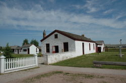
, but charged a toll for other users. The ferry was manned by groups of Mormons every summer from 1848 until 1852. In 1853 John Baptiste Richard built a toll bridge near the ferry site, which would eventually put all ferries on the North Platte out of business. In 1859, Louis Guinard built the Platte Bridge near the site of the original Mormon Ferry. Guinard also built a trading post at one end of the bridge which eventually became Fort Caspar
.
Famous landmarks along the southern route included Ayres Natural Bridge
and Register Cliff
, one of a number of locations along the trail in Wyoming where settlers carved their names.
 Continuing upstream from Casper, the North Platte bends to the south. The original trail proceeded several miles along the river to Red Buttes, where a bend in the river formed a natural amphitheater dominated by red cliffs on the hill above. The river was easier to ford here for those who were unwilling or unable to pay to cross at one of the ferries downstream. This was the last good camp spot before leaving the river and entering the waterless stretch between the North Platte and the Sweetwater River
. From here the settlers entered a difficult portion called Rock Avenue which moved from spring to spring across mostly alkaline soil and steep hills until it reached the Sweetwater River. Later settlers who had crossed to the northern side of the river at Casper would come to favor a route through a small valley called Emigrant Gap which headed directly to Rock Avenue, bypassing Red Buttes.
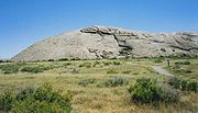
 Upon arrival in the Sweetwater valley, the trail encounters one of the most important landmarks on the trail, Independence Rock
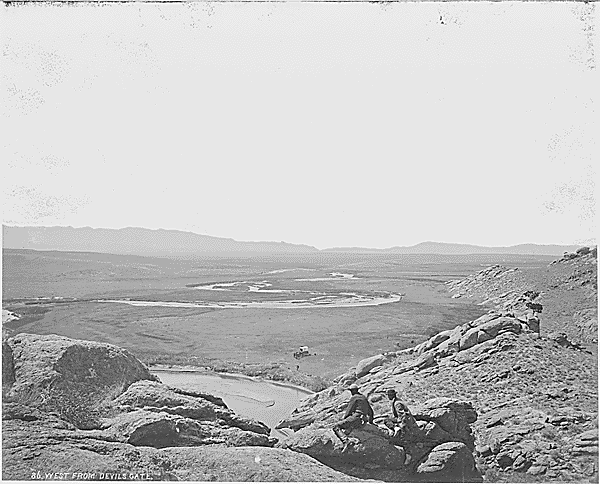
. Independence Rock was named because settlers tried to reach it by July 4 (Independence Day
in the United States) in order to help ensure that they will be at their destinations in California or Oregon before the winter snows come. Many of the travelers left their names on the rock, either carved or painted on with axle grease. It is estimated that more than 50,000 signatures were inscribed on Independence Rock. Other notable landmarks along the Sweetwater valley include Split Rock, Devil's Gate
and Martin's Cove
, where, in November 1856, the Martin Handcart Company
were stranded by heavy snow until a rescue party from Salt Lake City
arrived.
The trail continues west along the Sweetwater River eventually crossing the meandering river nine times, including three times within a 2 miles (3.2 km) section through a narrow canyon in the Rattlesnake Hills. Prior to the 6th crossing, the trail crossed an unusual location known as Ice Slough. A covering of peat like vegetation grew over a small stream. The stream froze in winter and didn't thaw until early summer due to the insulating layer of vegetation. The ice was a welcome treat for settlers who were enduring temperatures over 90 °F (32.2 °C) in July. The trail crosses the Sweetwater three more times and encounters a large hill known as Rocky Ridge on the northern side of the river. This barren and rocky section of the lasted almost 12 miles (19.3 km), and was considered a major obstacle in the trail. The same storm in November 1856 that debilitated the Martin Handcart Company also stranded the Willie Handcart Company on the eastern side of the ridge. Before rescuers could arrive, 21 people died in freezing temperatures. Following Rocky Ridge, the trail descends one more time into the Sweetwater valley to the ninth and final crossing of the Sweetwater at Burnt Ranch.
In 1853, a new route named Seminoe cutoff was established on the southern side of the river. It was named after trapper Basil LaJeunesse who was referred to as Seminoe by the Shoshone
Indians. The Seminoe cutoff split from the main trail at the 6th crossing and rejoined it at Burnt Ranch, bypassing both Rocky Ridge and four of the river crossings, which was an advantage in the early spring and summer during high runoff. The route was used extensively in the 1850s, especially by the Mormon companies.
 Immediately after crossing the Sweetwater at Burnt Ranch the trail crosses the continental divide
at South Pass
, unarguably the most important landmark on the entire trail. South Pass itself is an unimpressive open saddle between the Wind River Range to the north and the Antelope Hills to the south, but it represented a major milestone in the trip. In 1848, Congress
created the Oregon Territory
which included all the territory in Wyoming west of the Continental Divide. Crossing South Pass meant that the settlers had truly arrived in the Oregon Territory, though their ultimate destination was still a great distance away. Nearby Pacific Springs offered the first water since the trail had left the Sweetwater River and marked the beginning of a relatively dry stretch of trail until the settlers reached the Green River
more than 40 miles (64.4 km) away.
. True to its name, the water level on the Dry Sandy varied depending on the time of year and was often dry. South of the Dry Sandy ford, the trail split into two major sections, the main route which continues south to Fort Bridger
, and the Sublette cutoff, which proceeds west directly to the Green River and Bear River
valleys, bypassing Fort Bridger. The point at which the trails diverge is known as Parting of the Ways. 11 miles (17.7 km) south the main trail fords the Little Sandy. Here, a secondary path to the Sublette cutoff leads from the Litty Sandy Pony Express
station that was based here during the emigration period. The main trail goes on to ford the Big Sandy near the present day town of Farson
. The trail proceeds along the northern side of the Big Sandy to its confluence with the Green River
. Fording the Green River was very risky, so most travelers used one of a number of ferries operating on the Green River, including the Lombard Ferry and the Robinson Ferry.
 Continuing toward Fort Bridger from the Green River, the main trail crosses Hams Fork near Granger
and followed Blacks Fork
to Fort Bridger
. Established in 1842 by legendary frontiersman Jim Bridger
and his partner Louis Vasquez
, Fort Bridger was a vital refueling post and a welcome rest after the particularly difficult journey from South Pass. Even after the Sublette cutoff was established, settlers destined for Oregon who were low on livestock and supplies would bypass the cutoffs and make the longer trip to Fort Bridger to restock. Fort Bridger is the point at which the Mormon Trail
splits from the Oregon Trail
and California Trail
for good. The Mormon Trail continues southwest, fording the Bear River
and crossing into Utah
south of the current town of Evanston
. The other trails turn and proceed northwest, crossing the Bear River Divide and into the Bear River
valley on the western side of the state. The trail meets the Sublette cutoff near Cokeville
and the rejoined trails follow the Bear River upstream and into Idaho, heading for Fort Hall
.
led by mountaineers Caleb Greenwood
and Isaac Hitchcock. Hitchcock, an old mountain man and trapper and one of the first of his kind to have been in California in 1832, recommended that the wagon trail go due west from the Little Sandy and cross 40 miles (64.4 km) of desert territory to the Green River and from there cross the ridge into the Bear River Valley, completely bypassing Fort Bridger and the crossing of Bear River Ridge. The route shaved about 85 miles (136.8 km) and 7 days off the main route, but the decision to cross nearly 45 waterless miles before reaching the Green River was not one to be taken lightly. Settlers had to decide between time and the health of their livestock. A traveler in 1846 wrote: The route reached the height of popularity during the California Gold Rush
of the 1850s when a desire to speed to the California gold fields outweighed the risks. The route was named the Sublette cutoff by Joseph Ware in his popular 1849 guide book to the trail after an individual named Solomon Sublette who told him about the route, and not William Sublette
as is popular myth. The popularity of the guide book during the 1850s cemented the name, though most scholars today call it the Sublette-Greenwood Cutoff after its original discoverer.
As on the main route, several ferries operated where the cutoff crossed the Green River
near the present day town of La Barge
. Early settlers crossed the Names Hill Ford, which was barely passable when the water was low. Later The Names Hill Ferry offered a safer alternative. The nearby Mormon Ferry was located a mile upstream, and the Mountain Man Ferry operated during the Gold Rush days. West of the ford is its namesake, Names Hill
, which is a prominent emigrant "recording area" with signatures and other carvings. One notable signature is James Bridger,1844,Trapper. It is unclear if the signature is authentic, since Bridger
was known to be illiterate. The hill also features native American
pictographs.
A secondary cutoff named the Slate Creek or Kinney Cutoff breaks from the main trail near the Lombard Ferry on the Green River, and meets the Sublette cutoff on Slate Creek Ridge. This route was slightly longer than the Sublette, but had the advantage of only 10 waterless miles rather than the 45 endured on the Sublette trail.
 In 1857 increased traffic along the Emigrant Trail encouraged the federal government to investigate ways to improve the road to the western states. Expeditions under the command of Frederick W. Lander
surveyed a new route starting at Burnt Ranch following the last crossing of the Sweetwater River. The new road splits from the main trail and follows the Sweetwater further upstream toward its source. The trail eventually crosses the continental divide north of South Pass and proceeds through sparsely-forested high altitude region at the southern edge of the Wind River Range
. The route fords the Green River near Big Piney, Wyoming
and then transverses the Wyoming Range
, Grey's River, and Salt River Range
before descending into the Salt River
valley, eventually leaving the state near Afton
. In Idaho, the road proceeded due west until it met the main trail before arriving at Fort Hall
.
By crossing the lush Wyoming and Salt River Ranges instead of circling via the deserts to the south, the route provided ample wood, grass and water for the travelers, and cut nearly 7 days off the total travel time for wagon trails. Despite the better conditions for livestock, the mountainous terrain and unpredictable weather still proved to be dangerous for travelers. Funds were appropriated in 1858 and 115 men completed the road in 90 days, clearing timber and moving 62000 cubic yards (47,402.4 m³) of earth. The road, which was the first government road project in the west, opened in 1859 and remained in use until 1912, when automobiles made it obsolete.
Oregon Trail
The Oregon Trail is a historic east-west wagon route that connected the Missouri River to valleys in Oregon and locations in between.After 1840 steam-powered riverboats and steamboats traversing up and down the Ohio, Mississippi and Missouri rivers sped settlement and development in the flat...
, California Trail
California Trail
The California Trail was an emigrant trail of about across the western half of the North American continent from Missouri River towns to what is now the state of California...
and Mormon Trail
Mormon Trail
The Mormon Trail or Mormon Pioneer Trail is the 1,300 mile route that members of The Church of Jesus Christ of Latter-day Saints traveled from 1846 to 1868...
(collectively referred to as the Emigrant Trail
Emigrant Trail
The Emigrant Trails were the northern networks of overland wagon trails throughout the American West, used by emigrants from the eastern United States to settle lands west of the Interior Plains during the overland migrations of the mid-19th century...
) spans 400 miles (643.7 km) through the U.S. state
U.S. state
A U.S. state is any one of the 50 federated states of the United States of America that share sovereignty with the federal government. Because of this shared sovereignty, an American is a citizen both of the federal entity and of his or her state of domicile. Four states use the official title of...
of Wyoming
Wyoming
Wyoming is a state in the mountain region of the Western United States. The western two thirds of the state is covered mostly with the mountain ranges and rangelands in the foothills of the Eastern Rocky Mountains, while the eastern third of the state is high elevation prairie known as the High...
. The trail enters from Nebraska
Nebraska
Nebraska is a state on the Great Plains of the Midwestern United States. The state's capital is Lincoln and its largest city is Omaha, on the Missouri River....
on the eastern border of the state near the present day town of Torrington
Torrington, Wyoming
Torrington is a city in and the county seat of Goshen County, Wyoming, United States. The population was 5,776 at the 2000 census. Torrington is the home of Eastern Wyoming College....
and exited on the western border near the towns of Cokeville
Cokeville, Wyoming
Cokeville is a town in Lincoln County, Wyoming, United States. The population was 506 at the 2000 census.-Geography:Cokeville is located at ....
and Afton
Afton, Wyoming
Afton is a town in Lincoln County, Wyoming, United States. The population was 1,818 at the 2000 census.Afton is home to the world's largest elk horn arch...
. An estimated 350,000 to 400,000 settlers traveled on the trail through Wyoming between 1841 and 1868. All three trails follow the same path through most of the state. The Mormon Trail splits at Fort Bridger
Fort Bridger
Fort Bridger was originally a 19th century fur trading outpost established in 1842 on Blacks Fork of the Green River and later a vital resupply point for wagon trains on the Oregon Trail, California Trail and Mormon Trail. The Army established a military post here in 1858 during the Utah War until...
and enters Utah
Utah
Utah is a state in the Western United States. It was the 45th state to join the Union, on January 4, 1896. Approximately 80% of Utah's 2,763,885 people live along the Wasatch Front, centering on Salt Lake City. This leaves vast expanses of the state nearly uninhabited, making the population the...
, while the Oregon and California Trails continue to Idaho
Idaho
Idaho is a state in the Rocky Mountain area of the United States. The state's largest city and capital is Boise. Residents are called "Idahoans". Idaho was admitted to the Union on July 3, 1890, as the 43rd state....
.
North Platte River
North Platte River
The North Platte River is a major tributary of the Platte River and is approximately long counting its many curves, It travels about distance. Its course lies in the U.S...
into Wyoming. The trail follows the river upstream to Fort Laramie, a prominent military and trading post in the region. Prior to 1850 the northern side of the river was thought to be impassable beyond Fort Laramie, so the wagon trains that were traveling on the northern side of the river through Nebraska had to undertake a dangerous crossing at the fort. After crossing, trains on the main trail to the south of the river had to cross the North Platte again 100 miles (160.9 km) upstream. In 1850 several wagon trains successfully blazed a path along the northern side of the river. This new route, which reduced the risk and expense of crossing the river twice, was preferred for all subsequent traffic on the northern side of the river. The northern route is sometimes called Child's Route after Andrew Child who describe it in a guide book published in 1852. Above Fort Laramie, Child's Route follows the North Platte River through the present day town of Douglas
Douglas, Wyoming
Douglas is a city in Converse County, Wyoming, United States. The population was 5,288 at the 2000 census. It is the county seat of Converse County...
, and near the site of Fort Fetterman
Fort Fetterman
Fort Fetterman was a wooden fort constructed in 1867 by the United States Army on the Great Plains frontier in the Dakota Territory approximately 11 miles northwest of present-day Douglas, Wyoming. It was located high on the bluffs on the south side of the North Platte River...
which was built in 1867. This is the point at which the Bozeman Trail
Bozeman Trail
The Bozeman Trail was an overland route connecting the gold rush territory of Montana to the Oregon Trail. Its most important period was from 1863-1868. The flow of pioneers and settlers through territory of American Indians provoked their resentment and caused attacks. The U.S. Army undertook...
turned north to the gold fields of Montana in the 1860s.
The southern route also follows the river along the edge of the Laramie Mountains
Laramie Mountains
The Laramie Mountains are a range of moderately high peaks on the eastern edge of the Rocky Mountains in the U.S states of Wyoming and Colorado. The range is the northernmost extension of the line of the ranges along the eastern side of the Rockies, and in particular of the higher peaks of the...
to an area near the current towns of Casper
Casper, Wyoming
Casper is the county seat of Natrona County, Wyoming, United States.. Casper is the second-largest city in Wyoming , according to the 2010 census, with a population of 55,316...
and Glenrock
Glenrock, Wyoming
Glenrock is a town in Converse County, Wyoming, United States. The population was 2,231 at the 2000 census.Glenrock, known as Deer Creek Station, had its beginning as a mail and stage station along the Oregon Trail. The station served as a relay and eating place and was a vital supply point for...
. In 1847, during the first Mormon
Mormon
The term Mormon most commonly denotes an adherent, practitioner, follower, or constituent of Mormonism, which is the largest branch of the Latter Day Saint movement in restorationist Christianity...
emigration, Brigham Young
Brigham Young
Brigham Young was an American leader in the Latter Day Saint movement and a settler of the Western United States. He was the President of The Church of Jesus Christ of Latter-day Saints from 1847 until his death in 1877, he founded Salt Lake City, and he served as the first governor of the Utah...
established a ferry near present day Casper known as Mormon Ferry. The next year the ferry was moved a few miles downriver. The ferry was free for Latter Day Saints
Mormons
The Mormons are a religious and cultural group related to Mormonism, a religion started by Joseph Smith during the American Second Great Awakening. A vast majority of Mormons are members of The Church of Jesus Christ of Latter-day Saints while a minority are members of other independent churches....
, but charged a toll for other users. The ferry was manned by groups of Mormons every summer from 1848 until 1852. In 1853 John Baptiste Richard built a toll bridge near the ferry site, which would eventually put all ferries on the North Platte out of business. In 1859, Louis Guinard built the Platte Bridge near the site of the original Mormon Ferry. Guinard also built a trading post at one end of the bridge which eventually became Fort Caspar
Fort Caspar
Fort Caspar was a military post of the United States Army in present-day Wyoming, named after 2nd Lieutenant Caspar Collins, a U.S. Army officer who was killed in the 1865 Battle of the Platte Bridge Station against the Lakota and Cheyenne...
.
Famous landmarks along the southern route included Ayres Natural Bridge
Ayres Natural Bridge State Park
Ayres Natural Bridge Park is a county park in Converse County, Wyoming in the United States. It occupies 150 acres between the towns Glenrock and Douglas about 6 kilometers south of Interstate 25 exit 151...
and Register Cliff
Register Cliff
Register Cliff is a sandstone cliff and featured key navigational landmark prominently listed in the 19th century guidebooks about the Oregon Trail, and a place where many emigrants chiseled the names of their families on the soft stones of the cliff it was one of the key checkpoint landmarks for...
, one of a number of locations along the trail in Wyoming where settlers carved their names.
Sweetwater River
Sweetwater River (Wyoming)
The Sweetwater River is a tributary of the North Platte River, long, in the U.S. state of Wyoming. Its waters eventually reach the Atlantic Ocean. The Sweetwater rises in southwestern Fremont County, at the continental divide near South Pass Wyoming, on the southern end of the Wind River Range...
. From here the settlers entered a difficult portion called Rock Avenue which moved from spring to spring across mostly alkaline soil and steep hills until it reached the Sweetwater River. Later settlers who had crossed to the northern side of the river at Casper would come to favor a route through a small valley called Emigrant Gap which headed directly to Rock Avenue, bypassing Red Buttes.
Independence Rock
Independence Rock may refer to:*Independence Rock , a well-known landmark on the Oregon Trail*Independence Rock...
. Independence Rock was named because settlers tried to reach it by July 4 (Independence Day
Independence Day (United States)
Independence Day, commonly known as the Fourth of July, is a federal holiday in the United States commemorating the adoption of the Declaration of Independence on July 4, 1776, declaring independence from the Kingdom of Great Britain...
in the United States) in order to help ensure that they will be at their destinations in California or Oregon before the winter snows come. Many of the travelers left their names on the rock, either carved or painted on with axle grease. It is estimated that more than 50,000 signatures were inscribed on Independence Rock. Other notable landmarks along the Sweetwater valley include Split Rock, Devil's Gate
Devil's Gate (Wyoming)
Devil's Gate is a natural rock formation, a gorge on the Sweetwater River a few miles southwest of Independence Rock. The site, significant in the history of western pioneers, was a major landmark on the Mormon Trail and the Oregon Trail although the actual routes of travel did not pass through...
and Martin's Cove
Martin's Cove
Martin's Cove is a historic site in Wyoming. The 933 acre cove is located 55 miles southwest of Casper, Wyoming, in Natrona County. It is located on the Mormon Trail and is also part of the North Platte-Sweetwater segment of the Oregon Trail...
, where, in November 1856, the Martin Handcart Company
Mormon handcart pioneers
The Mormon handcart pioneers were participants in the migration of members of The Church of Jesus Christ of Latter-day Saints to Salt Lake City, Utah, who used handcarts to transport their belongings...
were stranded by heavy snow until a rescue party from Salt Lake City
Salt Lake City, Utah
Salt Lake City is the capital and the most populous city of the U.S. state of Utah. The name of the city is often shortened to Salt Lake or SLC. With a population of 186,440 as of the 2010 Census, the city lies in the Salt Lake City metropolitan area, which has a total population of 1,124,197...
arrived.
The trail continues west along the Sweetwater River eventually crossing the meandering river nine times, including three times within a 2 miles (3.2 km) section through a narrow canyon in the Rattlesnake Hills. Prior to the 6th crossing, the trail crossed an unusual location known as Ice Slough. A covering of peat like vegetation grew over a small stream. The stream froze in winter and didn't thaw until early summer due to the insulating layer of vegetation. The ice was a welcome treat for settlers who were enduring temperatures over 90 °F (32.2 °C) in July. The trail crosses the Sweetwater three more times and encounters a large hill known as Rocky Ridge on the northern side of the river. This barren and rocky section of the lasted almost 12 miles (19.3 km), and was considered a major obstacle in the trail. The same storm in November 1856 that debilitated the Martin Handcart Company also stranded the Willie Handcart Company on the eastern side of the ridge. Before rescuers could arrive, 21 people died in freezing temperatures. Following Rocky Ridge, the trail descends one more time into the Sweetwater valley to the ninth and final crossing of the Sweetwater at Burnt Ranch.
In 1853, a new route named Seminoe cutoff was established on the southern side of the river. It was named after trapper Basil LaJeunesse who was referred to as Seminoe by the Shoshone
Shoshone
The Shoshone or Shoshoni are a Native American tribe in the United States with three large divisions: the Northern, the Western and the Eastern....
Indians. The Seminoe cutoff split from the main trail at the 6th crossing and rejoined it at Burnt Ranch, bypassing both Rocky Ridge and four of the river crossings, which was an advantage in the early spring and summer during high runoff. The route was used extensively in the 1850s, especially by the Mormon companies.
Continental divide
A continental divide is a drainage divide on a continent such that the drainage basin on one side of the divide feeds into one ocean or sea, and the basin on the other side either feeds into a different ocean or sea, or else is endorheic, not connected to the open sea...
at South Pass
South Pass
South Pass is two mountain passes on the Continental Divide in the Rocky Mountains in southwestern Wyoming. The passes are located in a broad low region, 35 miles broad, between the Wind River Range to the north and the Oregon Buttes and Great Divide Basin to the south, in southwestern Fremont...
, unarguably the most important landmark on the entire trail. South Pass itself is an unimpressive open saddle between the Wind River Range to the north and the Antelope Hills to the south, but it represented a major milestone in the trip. In 1848, Congress
United States Congress
The United States Congress is the bicameral legislature of the federal government of the United States, consisting of the Senate and the House of Representatives. The Congress meets in the United States Capitol in Washington, D.C....
created the Oregon Territory
Oregon Territory
The Territory of Oregon was an organized incorporated territory of the United States that existed from August 14, 1848, until February 14, 1859, when the southwestern portion of the territory was admitted to the Union as the State of Oregon. Originally claimed by several countries , the region was...
which included all the territory in Wyoming west of the Continental Divide. Crossing South Pass meant that the settlers had truly arrived in the Oregon Territory, though their ultimate destination was still a great distance away. Nearby Pacific Springs offered the first water since the trail had left the Sweetwater River and marked the beginning of a relatively dry stretch of trail until the settlers reached the Green River
Green River (Utah)
The Green River, located in the western United States, is the chief tributary of the Colorado River. The watershed of the river, known as the Green River Basin, covers parts of Wyoming, Utah, and Colorado. The Green River is long, beginning in the Wind River Mountains of Wyoming and flowing...
more than 40 miles (64.4 km) away.
Sandy River
Leaving Pacific Springs, the trail moves southwest alongside Pacific Creek for a short distance until it swoops to the west to intersect Dry Sandy creek, a small stream that is a tributary of the Little Sandy River which in turn flows into the Big Sandy RiverBig Sandy River (Wyoming)
right|thumb|300px|Big Sandy Creek, WyomingThe Big Sandy River is a tributary of the Green River in Wyoming in the United States....
. True to its name, the water level on the Dry Sandy varied depending on the time of year and was often dry. South of the Dry Sandy ford, the trail split into two major sections, the main route which continues south to Fort Bridger
Fort Bridger
Fort Bridger was originally a 19th century fur trading outpost established in 1842 on Blacks Fork of the Green River and later a vital resupply point for wagon trains on the Oregon Trail, California Trail and Mormon Trail. The Army established a military post here in 1858 during the Utah War until...
, and the Sublette cutoff, which proceeds west directly to the Green River and Bear River
Bear River (Utah)
The Bear River is a river, approximately long, in southwestern Wyoming, southeastern Idaho, and northern Utah, in the United States. The largest tributary of the Great Salt Lake, it drains a mountainous area and farming valleys northeast of the lake and southeast of the Snake River Plain...
valleys, bypassing Fort Bridger. The point at which the trails diverge is known as Parting of the Ways. 11 miles (17.7 km) south the main trail fords the Little Sandy. Here, a secondary path to the Sublette cutoff leads from the Litty Sandy Pony Express
Pony Express
The Pony Express was a fast mail service crossing the Great Plains, the Rocky Mountains, and the High Sierra from St. Joseph, Missouri, to Sacramento, California, from April 3, 1860 to October 1861...
station that was based here during the emigration period. The main trail goes on to ford the Big Sandy near the present day town of Farson
Farson, Wyoming
Farson is a census-designated place in Sweetwater County, Wyoming, United States. The population was 242 at the 2000 census.-Geography:Farson is located at ....
. The trail proceeds along the northern side of the Big Sandy to its confluence with the Green River
Green River (Utah)
The Green River, located in the western United States, is the chief tributary of the Colorado River. The watershed of the river, known as the Green River Basin, covers parts of Wyoming, Utah, and Colorado. The Green River is long, beginning in the Wind River Mountains of Wyoming and flowing...
. Fording the Green River was very risky, so most travelers used one of a number of ferries operating on the Green River, including the Lombard Ferry and the Robinson Ferry.
Fort Bridger
Granger, Wyoming
Granger is a town in Sweetwater County, Wyoming, United States. The population was 146 at the 2000 census.-Geography:Granger is located at ....
and followed Blacks Fork
Blacks Fork
Blacks Fork is a tributary of the Green River in Utah and Wyoming. The river rises on the northern side of the Uinta Mountains as the combination of three streams draining the area around Tokewanna Peak near the Utah-Wyoming border...
to Fort Bridger
Fort Bridger
Fort Bridger was originally a 19th century fur trading outpost established in 1842 on Blacks Fork of the Green River and later a vital resupply point for wagon trains on the Oregon Trail, California Trail and Mormon Trail. The Army established a military post here in 1858 during the Utah War until...
. Established in 1842 by legendary frontiersman Jim Bridger
Jim Bridger
James Felix "Jim" Bridger was among the foremost mountain men, trappers, scouts and guides who explored and trapped the Western United States during the decades of 1820-1850, as well as mediating between native tribes and encroaching whites...
and his partner Louis Vasquez
Louis Vasquez
Pierre Luis Vasquez was a mountain man and trader. He was born and raised at St. Louis, Missouri. Pierre Luis Vasquez was the son of Benito Vasquez and Marie-Julie Papin Pierre Luis Vasquez (October 3, 1798 – September 5, 1868) was a mountain man and trader. He was born and raised at St....
, Fort Bridger was a vital refueling post and a welcome rest after the particularly difficult journey from South Pass. Even after the Sublette cutoff was established, settlers destined for Oregon who were low on livestock and supplies would bypass the cutoffs and make the longer trip to Fort Bridger to restock. Fort Bridger is the point at which the Mormon Trail
Mormon Trail
The Mormon Trail or Mormon Pioneer Trail is the 1,300 mile route that members of The Church of Jesus Christ of Latter-day Saints traveled from 1846 to 1868...
splits from the Oregon Trail
Oregon Trail
The Oregon Trail is a historic east-west wagon route that connected the Missouri River to valleys in Oregon and locations in between.After 1840 steam-powered riverboats and steamboats traversing up and down the Ohio, Mississippi and Missouri rivers sped settlement and development in the flat...
and California Trail
California Trail
The California Trail was an emigrant trail of about across the western half of the North American continent from Missouri River towns to what is now the state of California...
for good. The Mormon Trail continues southwest, fording the Bear River
Bear River (Utah)
The Bear River is a river, approximately long, in southwestern Wyoming, southeastern Idaho, and northern Utah, in the United States. The largest tributary of the Great Salt Lake, it drains a mountainous area and farming valleys northeast of the lake and southeast of the Snake River Plain...
and crossing into Utah
Utah
Utah is a state in the Western United States. It was the 45th state to join the Union, on January 4, 1896. Approximately 80% of Utah's 2,763,885 people live along the Wasatch Front, centering on Salt Lake City. This leaves vast expanses of the state nearly uninhabited, making the population the...
south of the current town of Evanston
Evanston, Wyoming
Evanston is a city in Uinta County, Wyoming, United States. The population was 12,359 at the 2010 census. It is the county seat of Uinta County.-Geography:Evanston is located at...
. The other trails turn and proceed northwest, crossing the Bear River Divide and into the Bear River
Bear River (Utah)
The Bear River is a river, approximately long, in southwestern Wyoming, southeastern Idaho, and northern Utah, in the United States. The largest tributary of the Great Salt Lake, it drains a mountainous area and farming valleys northeast of the lake and southeast of the Snake River Plain...
valley on the western side of the state. The trail meets the Sublette cutoff near Cokeville
Cokeville, Wyoming
Cokeville is a town in Lincoln County, Wyoming, United States. The population was 506 at the 2000 census.-Geography:Cokeville is located at ....
and the rejoined trails follow the Bear River upstream and into Idaho, heading for Fort Hall
Fort Hall
Fort Hall, sitting athwart the end of the common stretch shared by the three far west emigrant trails was a 19th century outpost in the eastern Oregon Country, which eventually became part of the present-day United States, and is located in southeastern Idaho near Fort Hall, Idaho...
.
Sublette-Greenwood Cutoff
The Sublette-Greenwood Cutoff was opened in 1844 by the Stephens-Townsend-Murphy PartyStephens-Townsend-Murphy Party
The Stephens-Townsend-Murphy Party consisted of ten families who migrated from Iowa to California prior to the Mexican-American War or the California Gold Rush. The Stephens Party is significant in California history because they were the first wagon train to cross the Sierra Nevada during the...
led by mountaineers Caleb Greenwood
Caleb Greenwood
Caleb Greenwood was a Western U.S. fur trapper and trail guide. Born in Virginia, Greenwood took part in trapping expeditions organized by associates of John Jacob Astor in 1810 and by Manuel Lisa in 1812-1813...
and Isaac Hitchcock. Hitchcock, an old mountain man and trapper and one of the first of his kind to have been in California in 1832, recommended that the wagon trail go due west from the Little Sandy and cross 40 miles (64.4 km) of desert territory to the Green River and from there cross the ridge into the Bear River Valley, completely bypassing Fort Bridger and the crossing of Bear River Ridge. The route shaved about 85 miles (136.8 km) and 7 days off the main route, but the decision to cross nearly 45 waterless miles before reaching the Green River was not one to be taken lightly. Settlers had to decide between time and the health of their livestock. A traveler in 1846 wrote: The route reached the height of popularity during the California Gold Rush
California Gold Rush
The California Gold Rush began on January 24, 1848, when gold was found by James W. Marshall at Sutter's Mill in Coloma, California. The first to hear confirmed information of the gold rush were the people in Oregon, the Sandwich Islands , and Latin America, who were the first to start flocking to...
of the 1850s when a desire to speed to the California gold fields outweighed the risks. The route was named the Sublette cutoff by Joseph Ware in his popular 1849 guide book to the trail after an individual named Solomon Sublette who told him about the route, and not William Sublette
William Sublette
William Lewis Sublette Born near Stamford, Lincoln County, Kentucky on September 21, 1798. Died on July 23, 1845 in Pittsburg. W.L. Sublette was a fur trapper, pioneer and mountain man, who with his brothers after 1823 became an agent of the Rocky Mountain Fur Company exploiting the riches of the...
as is popular myth. The popularity of the guide book during the 1850s cemented the name, though most scholars today call it the Sublette-Greenwood Cutoff after its original discoverer.
As on the main route, several ferries operated where the cutoff crossed the Green River
Green River (Utah)
The Green River, located in the western United States, is the chief tributary of the Colorado River. The watershed of the river, known as the Green River Basin, covers parts of Wyoming, Utah, and Colorado. The Green River is long, beginning in the Wind River Mountains of Wyoming and flowing...
near the present day town of La Barge
La Barge, Wyoming
La Barge is a town in Lincoln County, Wyoming, United States. The population was 431 at the 2000 census. It is about 20 miles from Big Piney, Wyoming. The area around La Barge is rich in oil fields, and the town has three bars and four churches.-History:...
. Early settlers crossed the Names Hill Ford, which was barely passable when the water was low. Later The Names Hill Ferry offered a safer alternative. The nearby Mormon Ferry was located a mile upstream, and the Mountain Man Ferry operated during the Gold Rush days. West of the ford is its namesake, Names Hill
Names Hill
Names Hill is a bluff located on the bank of the Green River in the U.S. state of Wyoming, where travelers on the Oregon and California trails carved their names into the rock. It one of three notable "recording areas" along the emigrant trails in Wyoming along with Register Cliff and Independence...
, which is a prominent emigrant "recording area" with signatures and other carvings. One notable signature is James Bridger,1844,Trapper. It is unclear if the signature is authentic, since Bridger
Jim Bridger
James Felix "Jim" Bridger was among the foremost mountain men, trappers, scouts and guides who explored and trapped the Western United States during the decades of 1820-1850, as well as mediating between native tribes and encroaching whites...
was known to be illiterate. The hill also features native American
Native Americans in the United States
Native Americans in the United States are the indigenous peoples in North America within the boundaries of the present-day continental United States, parts of Alaska, and the island state of Hawaii. They are composed of numerous, distinct tribes, states, and ethnic groups, many of which survive as...
pictographs.
A secondary cutoff named the Slate Creek or Kinney Cutoff breaks from the main trail near the Lombard Ferry on the Green River, and meets the Sublette cutoff on Slate Creek Ridge. This route was slightly longer than the Sublette, but had the advantage of only 10 waterless miles rather than the 45 endured on the Sublette trail.
Lander Road
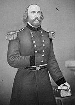
Frederick W. Lander
Frederick West Lander was a transcontinental United States explorer, general in the Union Army during the American Civil War, and a prolific poet.-Birth and early years:...
surveyed a new route starting at Burnt Ranch following the last crossing of the Sweetwater River. The new road splits from the main trail and follows the Sweetwater further upstream toward its source. The trail eventually crosses the continental divide north of South Pass and proceeds through sparsely-forested high altitude region at the southern edge of the Wind River Range
Wind River Range
The Wind River Range , is a mountain range of the Rocky Mountains in western Wyoming in the United States. The range runs roughly NW-SE for approximately 100 miles . The Continental Divide follows the crest of the range and includes Gannett Peak, which at 13,804 feet , is the highest peak...
. The route fords the Green River near Big Piney, Wyoming
Big Piney, Wyoming
Big Piney is a town in Sublette County, Wyoming, United States. The population was 408 at the 2000 census.-History:Big Piney is the oldest settlement in Sublette County. It was founded in 1879, when rancher Daniel B...
and then transverses the Wyoming Range
Wyoming Range
The Wyoming Range is a mountain range located in west-central Wyoming. It is a range of the Rocky Mountains that runs north-south near the western edge of the state. Its highest peak is Wyoming Peak, which stands at above sea-level. The range is sometimes referred to as The Wyomings.The vast...
, Grey's River, and Salt River Range
Salt River Range
The Salt River Range is a mountain range in western Wyoming. The 56 mile long range forms the eastern boundary of Star Valley as well as the western boundary of the Greys River valley.The highest point is Mount Fitzpatrick at ....
before descending into the Salt River
Salt River (Wyoming)
The Salt River is an river draining a valley in Lincoln County in western Wyoming. It is named for several exposed beds of salt and briny salt springs of up 60% pure salt in Idaho that drains into the Salt River via Stump Creek. The Salt River valley was a popular destination for Indians and later...
valley, eventually leaving the state near Afton
Afton, Wyoming
Afton is a town in Lincoln County, Wyoming, United States. The population was 1,818 at the 2000 census.Afton is home to the world's largest elk horn arch...
. In Idaho, the road proceeded due west until it met the main trail before arriving at Fort Hall
Fort Hall
Fort Hall, sitting athwart the end of the common stretch shared by the three far west emigrant trails was a 19th century outpost in the eastern Oregon Country, which eventually became part of the present-day United States, and is located in southeastern Idaho near Fort Hall, Idaho...
.
By crossing the lush Wyoming and Salt River Ranges instead of circling via the deserts to the south, the route provided ample wood, grass and water for the travelers, and cut nearly 7 days off the total travel time for wagon trails. Despite the better conditions for livestock, the mountainous terrain and unpredictable weather still proved to be dangerous for travelers. Funds were appropriated in 1858 and 115 men completed the road in 90 days, clearing timber and moving 62000 cubic yards (47,402.4 m³) of earth. The road, which was the first government road project in the west, opened in 1859 and remained in use until 1912, when automobiles made it obsolete.