

Evanston, Wyoming
Encyclopedia
Evanston is a city in Uinta County
, Wyoming
, United States
. The population was 12,359 at the 2010 census. It is the county seat
of Uinta County
.
According to the United States Census Bureau
, the city has a total area of 10.3 square miles (26.7 km²), of which, 10.2 square miles (26.5 km²) of it is land and 0.04 square miles (0.1 km²) of it (0.39%) is water.
Evanston has a continental climate
(Köppen climate classification
Dfb) with long, cold, dry winters and short, warm, slightly wetter summers.
. The town was founded during the construction of the First Transcontinental Railroad
. The railroad arrived in the area in November 1868, and Harvey Booth opened a saloon/restaurant in a tent near what is now Front Street. By December the rails had reached Evanston and the first train arrived December 16. Later a machine shop and roundhouse were constructed, giving Evanston a longevity not shared with many other railroad towns.
Abundant timber and water along the Bear River
made Evanston a refueling station for cross-country locomotives. Coal
was mined a few miles north of Evanston in Almy. Similar to other railroad towns in Wyoming, early Evanston had a large population of Chinese railroad workers — in Evanston they lived on the north side of the railroad tracks in a small "China town." Over time, the Chinese population dwindled, disappearing completely in the 1930s.
Evanston was a major stop on the Lincoln Highway
. The highway ran east to west from East Service Rd to Bear River Dr, on Front St to Harrison Dr, to Wasatch Rd southwest to Echo Canyon in Utah. It can still be seen along Interstate 80
, which follows the railroad tracks in this area.
Evanston underwent massive growth and change during an oil boom in the 1980s. Recent drilling for natural gas has also revitalized the economy of the area. Union Tank Car works on railroad tank cars near the old roundhouse and there are efforts to restore the roundhouse and the railroad historical buildings in the downtown area. One of the more recent restorations include 1011 Front Street where Michael’s Bar & Grill currently stands. This restaurant is the oldest Bar & Grill in Evanston and once served as a store house for one of the first JC Penny stores in the country. This building, located in historic downtown Evanston, is across the street from the museum in Depot Square.
 The Wyoming Department of Health
Wyoming State Hospital, a psychiatric facility, is located in Evanston. The facility was operated by the Wyoming Board of Charities and Reform
until that agency was dissolved as a result of a state constitutional amendment passed in November 1990.
 The United States Postal Service
operates the Evanston Post Office.
. The district operates a total of eight campuses, including four elementary schools (Aspen, Clark, North, and Uinta Meadows) serving grades Kindergarten through five, two middle schools (Davis and Evanston) serving grades six through eight, one high school (Evanston) serving grades nine through twelve, and one secondary alternative school (Horizon).
of 2000, there were 11,507 people, 4,058 households, and 2,937 families residing in the city. The population density
was 1,123.2 people per square mile (433.9/km²). There were 4,665 housing units at an average density of 455.4 per square mile (175.9/km²). The racial makeup of the city was 92.29% White, 0.16% African American, 1.06% Native American, 0.40% Asian, 0.08% Pacific Islander, 4.15% from other races
, and 1.87% from two or more races. Hispanic or Latino of any race were 7.29% of the population.
There were 4,058 households out of which 44.8% had children under the age of 18 living with them, 56.3% were married couples
living together, 11.7% had a female householder with no husband present, and 27.6% were non-families. 23.4% of all households were made up of individuals and 6.0% had someone living alone who was 65 years of age or older. The average household size was 2.77 and the average family size was 3.30.
In the city the population was spread out with 33.4% under the age of 18, 9.4% from 18 to 24, 30.1% from 25 to 44, 20.0% from 45 to 64, and 7.2% who were 65 years of age or older. The median age was 31 years. For every 100 females there were 101.2 males. For every 100 females age 18 and over, there were 97.4 males.
The median income for a household in the city was $42,019, and the median income for a family was $47,220. Males had a median income of $35,843 versus $21,710 for females. The per capita income
for the city was $16,725. About 9.1% of families and 11.7% of the population were below the poverty line, including 14.5% of those under age 18 and 5.4% of those age 65 or over.
Uinta County, Wyoming
-Demographics:As of the census of 2000, there were 19,742 people, 6,823 households, and 5,144 families residing in the county. The population density was 10 people per square mile . There were 8,011 housing units at an average density of 4 per square mile...
, Wyoming
Wyoming
Wyoming is a state in the mountain region of the Western United States. The western two thirds of the state is covered mostly with the mountain ranges and rangelands in the foothills of the Eastern Rocky Mountains, while the eastern third of the state is high elevation prairie known as the High...
, United States
United States
The United States of America is a federal constitutional republic comprising fifty states and a federal district...
. The population was 12,359 at the 2010 census. It is the county seat
County seat
A county seat is an administrative center, or seat of government, for a county or civil parish. The term is primarily used in the United States....
of Uinta County
Uinta County, Wyoming
-Demographics:As of the census of 2000, there were 19,742 people, 6,823 households, and 5,144 families residing in the county. The population density was 10 people per square mile . There were 8,011 housing units at an average density of 4 per square mile...
.
Geography
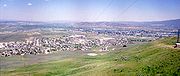
Evanston is located at 41°15′48"N 110°57′53"W (41.263302, -110.964616). The elevation is 6749 feet (2057 m) above sea level.According to the United States Census Bureau
United States Census Bureau
The United States Census Bureau is the government agency that is responsible for the United States Census. It also gathers other national demographic and economic data...
, the city has a total area of 10.3 square miles (26.7 km²), of which, 10.2 square miles (26.5 km²) of it is land and 0.04 square miles (0.1 km²) of it (0.39%) is water.
Evanston has a continental climate
Humid continental climate
A humid continental climate is a climatic region typified by large seasonal temperature differences, with warm to hot summers and cold winters....
(Köppen climate classification
Köppen climate classification
The Köppen climate classification is one of the most widely used climate classification systems. It was first published by Crimea German climatologist Wladimir Köppen in 1884, with several later modifications by Köppen himself, notably in 1918 and 1936...
Dfb) with long, cold, dry winters and short, warm, slightly wetter summers.
History
Evanston was named after James E. Evans, surveyor for the Union Pacific RailroadUnion Pacific Railroad
The Union Pacific Railroad , headquartered in Omaha, Nebraska, is the largest railroad network in the United States. James R. Young is president, CEO and Chairman....
. The town was founded during the construction of the First Transcontinental Railroad
First Transcontinental Railroad
The First Transcontinental Railroad was a railroad line built in the United States of America between 1863 and 1869 by the Central Pacific Railroad of California and the Union Pacific Railroad that connected its statutory Eastern terminus at Council Bluffs, Iowa/Omaha, Nebraska The First...
. The railroad arrived in the area in November 1868, and Harvey Booth opened a saloon/restaurant in a tent near what is now Front Street. By December the rails had reached Evanston and the first train arrived December 16. Later a machine shop and roundhouse were constructed, giving Evanston a longevity not shared with many other railroad towns.
Abundant timber and water along the Bear River
Bear River (Utah)
The Bear River is a river, approximately long, in southwestern Wyoming, southeastern Idaho, and northern Utah, in the United States. The largest tributary of the Great Salt Lake, it drains a mountainous area and farming valleys northeast of the lake and southeast of the Snake River Plain...
made Evanston a refueling station for cross-country locomotives. Coal
Coal
Coal is a combustible black or brownish-black sedimentary rock usually occurring in rock strata in layers or veins called coal beds or coal seams. The harder forms, such as anthracite coal, can be regarded as metamorphic rock because of later exposure to elevated temperature and pressure...
was mined a few miles north of Evanston in Almy. Similar to other railroad towns in Wyoming, early Evanston had a large population of Chinese railroad workers — in Evanston they lived on the north side of the railroad tracks in a small "China town." Over time, the Chinese population dwindled, disappearing completely in the 1930s.
Evanston was a major stop on the Lincoln Highway
Lincoln Highway
The Lincoln Highway was the first road across the United States of America.Conceived and promoted by entrepreneur Carl G. Fisher, the Lincoln Highway spanned coast-to-coast from Times Square in New York City to Lincoln Park in San Francisco, originally through 13 states: New York, New Jersey,...
. The highway ran east to west from East Service Rd to Bear River Dr, on Front St to Harrison Dr, to Wasatch Rd southwest to Echo Canyon in Utah. It can still be seen along Interstate 80
Interstate 80
Interstate 80 is the second-longest Interstate Highway in the United States, following Interstate 90. It is a transcontinental artery running from downtown San Francisco, California to Teaneck, New Jersey in the New York City Metropolitan Area...
, which follows the railroad tracks in this area.
Evanston underwent massive growth and change during an oil boom in the 1980s. Recent drilling for natural gas has also revitalized the economy of the area. Union Tank Car works on railroad tank cars near the old roundhouse and there are efforts to restore the roundhouse and the railroad historical buildings in the downtown area. One of the more recent restorations include 1011 Front Street where Michael’s Bar & Grill currently stands. This restaurant is the oldest Bar & Grill in Evanston and once served as a store house for one of the first JC Penny stores in the country. This building, located in historic downtown Evanston, is across the street from the museum in Depot Square.
Government and infrastructure
Wyoming Department of Health
The Wyoming Department of Health is a state agency of Wyoming. It has its headquarters in the Hathaway Building in Cheyenne.-History:...
Wyoming State Hospital, a psychiatric facility, is located in Evanston. The facility was operated by the Wyoming Board of Charities and Reform
Wyoming Board of Charities and Reform
The Wyoming Board of Charities and Reform was a state agency of Wyoming that operated the state's charitable and penal institutions.-History:...
until that agency was dissolved as a result of a state constitutional amendment passed in November 1990.
United States Postal Service
The United States Postal Service is an independent agency of the United States government responsible for providing postal service in the United States...
operates the Evanston Post Office.
Education
Public education in the city of Evanston is provided by Uinta County School District #1Uinta County School District Number 1
Uinta County School District #1 is a public school district based in Evanston, Wyoming, United States.-Geography:Uinta County School District #1 serves the western portion of Uinta County, including the following communities:*Incorporated places...
. The district operates a total of eight campuses, including four elementary schools (Aspen, Clark, North, and Uinta Meadows) serving grades Kindergarten through five, two middle schools (Davis and Evanston) serving grades six through eight, one high school (Evanston) serving grades nine through twelve, and one secondary alternative school (Horizon).
Demographics
As of the censusCensus
A census is the procedure of systematically acquiring and recording information about the members of a given population. It is a regularly occurring and official count of a particular population. The term is used mostly in connection with national population and housing censuses; other common...
of 2000, there were 11,507 people, 4,058 households, and 2,937 families residing in the city. The population density
Population density
Population density is a measurement of population per unit area or unit volume. It is frequently applied to living organisms, and particularly to humans...
was 1,123.2 people per square mile (433.9/km²). There were 4,665 housing units at an average density of 455.4 per square mile (175.9/km²). The racial makeup of the city was 92.29% White, 0.16% African American, 1.06% Native American, 0.40% Asian, 0.08% Pacific Islander, 4.15% from other races
Race (United States Census)
Race and ethnicity in the United States Census, as defined by the Federal Office of Management and Budget and the United States Census Bureau, are self-identification data items in which residents choose the race or races with which they most closely identify, and indicate whether or not they are...
, and 1.87% from two or more races. Hispanic or Latino of any race were 7.29% of the population.
There were 4,058 households out of which 44.8% had children under the age of 18 living with them, 56.3% were married couples
Marriage
Marriage is a social union or legal contract between people that creates kinship. It is an institution in which interpersonal relationships, usually intimate and sexual, are acknowledged in a variety of ways, depending on the culture or subculture in which it is found...
living together, 11.7% had a female householder with no husband present, and 27.6% were non-families. 23.4% of all households were made up of individuals and 6.0% had someone living alone who was 65 years of age or older. The average household size was 2.77 and the average family size was 3.30.
In the city the population was spread out with 33.4% under the age of 18, 9.4% from 18 to 24, 30.1% from 25 to 44, 20.0% from 45 to 64, and 7.2% who were 65 years of age or older. The median age was 31 years. For every 100 females there were 101.2 males. For every 100 females age 18 and over, there were 97.4 males.
The median income for a household in the city was $42,019, and the median income for a family was $47,220. Males had a median income of $35,843 versus $21,710 for females. The per capita income
Per capita income
Per capita income or income per person is a measure of mean income within an economic aggregate, such as a country or city. It is calculated by taking a measure of all sources of income in the aggregate and dividing it by the total population...
for the city was $16,725. About 9.1% of families and 11.7% of the population were below the poverty line, including 14.5% of those under age 18 and 5.4% of those age 65 or over.