

Sweetwater River (Wyoming)
Encyclopedia
North Platte River
The North Platte River is a major tributary of the Platte River and is approximately long counting its many curves, It travels about distance. Its course lies in the U.S...
, 238 miles (383 km) long, in the U.S. state
U.S. state
A U.S. state is any one of the 50 federated states of the United States of America that share sovereignty with the federal government. Because of this shared sovereignty, an American is a citizen both of the federal entity and of his or her state of domicile. Four states use the official title of...
of Wyoming
Wyoming
Wyoming is a state in the mountain region of the Western United States. The western two thirds of the state is covered mostly with the mountain ranges and rangelands in the foothills of the Eastern Rocky Mountains, while the eastern third of the state is high elevation prairie known as the High...
. Its waters eventually reach the Atlantic Ocean
Atlantic Ocean
The Atlantic Ocean is the second-largest of the world's oceanic divisions. With a total area of about , it covers approximately 20% of the Earth's surface and about 26% of its water surface area...
. The Sweetwater rises in southwestern Fremont County, at the continental divide near South Pass
South Pass
South Pass is two mountain passes on the Continental Divide in the Rocky Mountains in southwestern Wyoming. The passes are located in a broad low region, 35 miles broad, between the Wind River Range to the north and the Oregon Buttes and Great Divide Basin to the south, in southwestern Fremont...
Wyoming, on the southern end of the Wind River Range
Wind River Range
The Wind River Range , is a mountain range of the Rocky Mountains in western Wyoming in the United States. The range runs roughly NW-SE for approximately 100 miles . The Continental Divide follows the crest of the range and includes Gannett Peak, which at 13,804 feet , is the highest peak...
. It flows ENE along the north side of the Antelope Hills
Antelope Hills
-Communities:* Antelope Hills, California, Kern County, California* Antelope Hills, Colorado, Arapahoe County, Bennett, Colorado* Antelope Hills, Wyoming, Natrona County, Wyoming...
, then ESE, through Fremont County, past Jeffrey City
Jeffrey City, Wyoming
Jeffrey City is a census-designated place and former uranium mining boomtown located in Fremont County, in the central part of the U.S. state of Wyoming. The town is famous in Wyoming and the American West as symbol of a boomtown that went “bust” very quickly, as the mine was shut down in 1982...
, between the Granite Mountains
Granite Mountains (Wyoming)
The Granite Mountains are a short subrange of the Rocky Mountains in central Wyoming of the United States. The range runs approximately 100 mi E-W along the south side of the Shoshone Basin, and north of the Sweetwater River, in eastern Fremont County and western Natrona County. The highest...
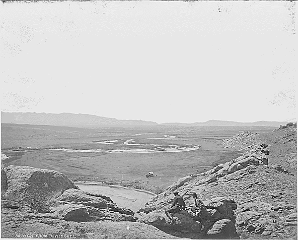
to the north and the Green Mountains (Wyoming) to the south, through what are now cattle-raising areas. In southern Natrona County, it passes Devil's Gate
Devil's Gate (Wyoming)
Devil's Gate is a natural rock formation, a gorge on the Sweetwater River a few miles southwest of Independence Rock. The site, significant in the history of western pioneers, was a major landmark on the Mormon Trail and the Oregon Trail although the actual routes of travel did not pass through...
and Independence Rock
Independence Rock (Wyoming)
Independence Rock is a large granite rock, approximately high, in southwestern Natrona County in the U.S. state of Wyoming, along Wyoming Highway 220. During the middle of the 19th century, the rock was a prominent and well-known landmark on the Oregon, Mormon and California emigrant trails. It...
along the Oregon
Oregon Trail
The Oregon Trail is a historic east-west wagon route that connected the Missouri River to valleys in Oregon and locations in between.After 1840 steam-powered riverboats and steamboats traversing up and down the Ohio, Mississippi and Missouri rivers sped settlement and development in the flat...
, California
California Trail
The California Trail was an emigrant trail of about across the western half of the North American continent from Missouri River towns to what is now the state of California...
and Mormon Trail
Mormon Trail
The Mormon Trail or Mormon Pioneer Trail is the 1,300 mile route that members of The Church of Jesus Christ of Latter-day Saints traveled from 1846 to 1868...
s, and empties into the North Platte as the Sweetwater arm of Pathfinder Reservoir
Pathfinder Reservoir
Pathfinder Reservoir is located in the U.S. state of Wyoming on the North Platte River between Casper and Rawlins. It sits 47 miles southwest of Casper, in Carbon County and Natrona County. The reservoir was created by Pathfinder Dam and has a storage capacity of . The shoreline consists of 117...
.
In fall of 1823, trappers and fur traders Jedediah Smith
Jedediah Smith
Jedediah Strong Smith was a hunter, trapper, fur trader, trailblazer, author, cartographer, cattleman, and explorer of the Rocky Mountains, the American West Coast and the Southwest during the 19th century...
and Thomas Fitzpatrick
Thomas Fitzpatrick (trapper)
Thomas Fitzpatrick, known as "Broken Hand", was a trapper and a trailblazer who became the head of the Rocky Mountain Fur Company. With Jedediah Smith, he led a trapper band that discovered South Pass, Wyoming....
led their trapping crew south from the Yellowstone River
Yellowstone River
The Yellowstone River is a tributary of the Missouri River, approximately long, in the western United States. Considered the principal tributary of the upper Missouri, the river and its tributaries drain a wide area stretching from the Rocky Mountains in the vicinity of the Yellowstone National...
to the Sweetwater River. They were looking for a safe location to spend the winter. Smith reasoned since the Sweetwater flowed east it must eventually run into the Missouri River. Trying to transport their extensive fur collection down the Sweetwater and North Platte River, they found after a near disastrous canoe crash that the rivers in Wyoming were too swift and rough for water passage. On July 4, 1824, they cached their furs under a dome of rock they named Independence Rock
Independence Rock (Wyoming)
Independence Rock is a large granite rock, approximately high, in southwestern Natrona County in the U.S. state of Wyoming, along Wyoming Highway 220. During the middle of the 19th century, the rock was a prominent and well-known landmark on the Oregon, Mormon and California emigrant trails. It...
and started their long trek on foot to the Missouri River via the Sweetwater, North Platte
North Platte River
The North Platte River is a major tributary of the Platte River and is approximately long counting its many curves, It travels about distance. Its course lies in the U.S...
and Platte River
Platte River
The Platte River is a major river in the state of Nebraska and is about long. Measured to its farthest source via its tributary the North Platte River, it flows for over . The Platte River is a tributary of the Missouri River, which in turn is a tributary of the Mississippi River which flows to...
valleys. Upon arriving back in a settled area on the Missouri River
Missouri River
The Missouri River flows through the central United States, and is a tributary of the Mississippi River. It is the longest river in North America and drains the third largest area, though only the thirteenth largest by discharge. The Missouri's watershed encompasses most of the American Great...
they bought pack horses (on credit) and retrieved their furs. They had re-discovered the route that Robert Stuart
Robert Stuart
Major Robert Stuart was an officer of the British Army and veteran of the Crimean War. After the war, he was appointed Vice-Consul at Volos and later Consul at Janina and Consul-General in various locations...
of the Astor Expedition
Astor Expedition
The Astor Expedition of 1810-1812 was the next overland expedition from St. Louis, Missouri to the mouth of the Columbia River after the Corps of Discovery, led by Lewis and Clark.-History:...
had taken in 1813—eleven years before. Thomas Fitzpatrick was often hired as a trail guide when the fur trade almost ceased in 1840. Jedediah Smith was killed by Indians about 1831.
The Sweetwater River valley provided a route used by fur trappers, mountain men
Mountain man
Mountain men were trappers and explorers who roamed the North American Rocky Mountains from about 1810 through the 1880s where they were instrumental in opening up the various Emigrant Trails allowing Americans in the east to settle the new territories of the far west by organized wagon trains...
and fur traders as they went to their annual summertime Rocky Mountain Rendezvouss located usually somewhere along the Green River
Green River (Utah)
The Green River, located in the western United States, is the chief tributary of the Colorado River. The watershed of the river, known as the Green River Basin, covers parts of Wyoming, Utah, and Colorado. The Green River is long, beginning in the Wind River Mountains of Wyoming and flowing...
Wyoming. These trappers and traders soon established a path for their pack trains along the Sweetwater and eventually cleared a rough wagon trail to the Green River.
By 1843 the Sweetwater River valley was a regular wagon trail providing the water, grass and fuel needed on the Oregon
Oregon Trail
The Oregon Trail is a historic east-west wagon route that connected the Missouri River to valleys in Oregon and locations in between.After 1840 steam-powered riverboats and steamboats traversing up and down the Ohio, Mississippi and Missouri rivers sped settlement and development in the flat...
, California
California Trail
The California Trail was an emigrant trail of about across the western half of the North American continent from Missouri River towns to what is now the state of California...
and Mormon Trail
Mormon Trail
The Mormon Trail or Mormon Pioneer Trail is the 1,300 mile route that members of The Church of Jesus Christ of Latter-day Saints traveled from 1846 to 1868...
s across Wyoming. The Sweetwater provided an almost direct path from the Platte
Platte River
The Platte River is a major river in the state of Nebraska and is about long. Measured to its farthest source via its tributary the North Platte River, it flows for over . The Platte River is a tributary of the Missouri River, which in turn is a tributary of the Mississippi River which flows to...
and North Platte River
North Platte River
The North Platte River is a major tributary of the Platte River and is approximately long counting its many curves, It travels about distance. Its course lies in the U.S...
s to the wide South Pass
South Pass
South Pass is two mountain passes on the Continental Divide in the Rocky Mountains in southwestern Wyoming. The passes are located in a broad low region, 35 miles broad, between the Wind River Range to the north and the Oregon Buttes and Great Divide Basin to the south, in southwestern Fremont...
Continental Divide
Continental Divide
The Continental Divide of the Americas, or merely the Continental Gulf of Division or Great Divide, is the name given to the principal, and largely mountainous, hydrological divide of the Americas that separates the watersheds that drain into the Pacific Ocean from those river systems that drain...
between the Atlantic Ocean
Atlantic Ocean
The Atlantic Ocean is the second-largest of the world's oceanic divisions. With a total area of about , it covers approximately 20% of the Earth's surface and about 26% of its water surface area...
rivers and rivers that dumped in the Pacific Ocean
Pacific Ocean
The Pacific Ocean is the largest of the Earth's oceanic divisions. It extends from the Arctic in the north to the Southern Ocean in the south, bounded by Asia and Australia in the west, and the Americas in the east.At 165.2 million square kilometres in area, this largest division of the World...
. South Pass was the easiest pass across the Atlantic and Pacific drainages. These wagon trails crossed the meandering Sweetwater River about nine times on their about 10 to 20 day trips along the Sweetwater River before they reached South Pass
South Pass
South Pass is two mountain passes on the Continental Divide in the Rocky Mountains in southwestern Wyoming. The passes are located in a broad low region, 35 miles broad, between the Wind River Range to the north and the Oregon Buttes and Great Divide Basin to the south, in southwestern Fremont...
.