
Effects of Hurricane Isabel in New Jersey
Encyclopedia
The effects of Hurricane Isabel in New Jersey in 2003 were overall moderate, limited to fallen trees, two deaths, and $50 million in damage (2003 USD, $59 million 2008 USD). Hurricane Isabel
formed from a tropical wave
on September 6 in the tropical Atlantic Ocean
. It moved northwestward, and within an environment of light wind shear and warm waters it steadily strengthened to reach peak winds of 165 mph (265 km/h) on September 11. After fluctuating in intensity for four days, Isabel gradually weakened and made landfall on the Outer Banks
of North Carolina
with winds of 105 mph (165 km/h) on September 18. It quickly weakened over land and became extratropical over western Pennsylvania
the next day. Several days before Isabel made landfall, there existed uncertainty in where the hurricane would strike. At least one computer model predicted a landfall on New Jersey
, and as a result services across the state thoroughly prepared for the hurricane.
Isabel passed 215 miles (350 km) southwest of the state, though its large wind core produced tropical storm force winds across much of the state. The winds downed hundreds of trees and power lines, leaving hundreds of thousands without power. A falling tree killed one person. Hurricane Isabel produced rough waves and a moderate storm surge along the coastline. One person was killed from the rough waves, and at least 50 locations along the Jersey Shore
reported beach erosion from the hurricane.
 44 hours before Hurricane Isabel made landfall on the Outer Banks of North Carolina, the National Hurricane Center
issued a tropical storm watch
for the coastline from Little Egg Inlet
southward into the Mid-Atlantic
. A day later, the watch was extended northward to Sandy Hook
. When Isabel was 26 hours from making landfall, the watches were changed to tropical storm warnings, and 10 hours before it struck land the National Hurricane Center issued a tropical storm warning for the remainder of the New Jersey coastline. The National Hurricane Center also briefly issued a hurricane watch for the New Jersey coastline. While over the western Atlantic Ocean as a Category 5 hurricane, forecasters predicted Isabel would move northwestward and within five days be at a position 170 miles (275 km) south of Cape May as a 115-mph (185-km/h) major hurricane. By four days before the hurricane struck land, at least one computer model
predicted Isabel would strike New Jersey.
News stations stationed crews along the Jersey shore several days in advance of Isabel to provide breaking news and live conditions. Many residents prepared their houses by boarding windows and purchasing emergency supplies. The Sussex County
chapter of the American Red Cross
advised local high schools to be on stand-by as potential shelters in the event evacuation occurred. Emergency coordinators in several counties were on alert, though none issued evacuations. In preparation for anticipated power outages, the Jersey Central Power and Light company arranged to receive more electrical crews from its parent company, FirstEnergy
. Other utility workers from various locations as far as Canada
left for the state in the event of power outages.
Several flights in and out of the state were delayed or canceled, and the Cape May-Lewes Ferry
canceled travel across the Delaware Bay
during the duration of Isabel. In Atlantic City, casino workers prepared for coastal flooding by placing sandbags at boardwalk entrances. New Jersey Transit
workers secured its buses, railways, and light rail equipment. To ensure service would remain accessible during and after the hurricane, NJ Transit prepared backup generators, pumps, and chainsaws, with workers inspecting trains and the paths of the lines. FEMA mobilized and dispatched an Urban Search and Rescue Task Force
of 28 people to the state for possible rescue duty. Days before the storm made landfall, the Salvation Army
prepared food and aid for potentially affected citizens. In anticipation for the effects of Isabel, Governor
Jim McGreevey
declared a state of emergency, which allowed the Federal Emergency Management Agency
to deal with the situation.
along the New Jersey coastline of up to 6.5 feet (2 m) in Cape May
. Higher amounts occurred along the Delaware River
, peaking in the state at 10.6 feet (3.2 m) in Burlington
. At its closest approach, Isabel passed within about 215 miles (350 km) of the state, and as a result the outer rainband
s produced light rainfall. Wildwood
along the southeast coast reported 1.3 inches (33 mm) of rain, while Lincoln Park
in the northern portion of the state recorded 2.07 inches (52 mm) of precipitation. The large wind field of the hurricane produced moderate winds across the state. A shoal
in the Delaware Bay experienced sustained winds of 54 mph (87 km/h) with gusts to 71 mph (114 km/h). Cape May reported tropical storm force winds with gusts to 61 mph (98 km/h), while Newark
in the northern portion of the state experienced gusts to 44 mph (71 km/h).
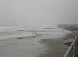
Hurricane Isabel produced slightly above normal tides and rough surf along the Jersey shore, killing one surfer off of Wildwood Crest
. The combination of gusty winds and the heavy surf produced moderate beach erosion along much of the coastline, primarily to beaches facing southeastward. In the Delaware Bay
and River area, no significant erosion was reported, though coastal flooding from the hurricane washed out a road and destroyed the deck of a house in Baypoint. In Cape May County
waves eroded the beaches by up to 4 feet (1.2 m) in Ocean City
and Avalon
, with several cities experiencing a loss of dunes and geotubes in Whale Beach
being exposed. Waves from Isabel in Atlantic County
resulted in light damage, minor coastal flooding, and slight beach erosion. The beaches of southern Ocean County
experienced a loss of 3 to 4 feet (0.9 to 1.2 m) of sand, while locations further to the north experienced only minor erosion. Most coastal areas of Monmouth County
reported eroded beaches by up to 4 feet (1.2 m), with Union Beach
losing about 5,000 sq. feet (465 sq. m) of sand.
Moderate wind gusts throughout the state downed hundreds of trees, tree limbs, and power lines. Over 382,000 people were without power, one of the worst power outages on record for area utilities. Downed trees and power lines closed major streets and schools in Union County
. One downed tree greatly damaged a house in Middletown, and in Hudson County
several trees fell onto and damaged cars. A downed tree in Englewood
injured a woman when she was struck, and a woman in Independence Township
was killed when a fallen tree landed on the vehicle she was driving. Strong winds from Isabel blew out the windows in an office building in East Rutherford
, causing injuries to two women when they were struck. Throughout the state, damage totaled to about $50 million (2003 USD, $59 million 2008 USD).
Hurricane Isabel
Hurricane Isabel was the costliest and deadliest hurricane in the 2003 Atlantic hurricane season. The ninth named storm, fifth hurricane, and second major hurricane of the season, Isabel formed near the Cape Verde Islands from a tropical wave on September 6 in the tropical Atlantic Ocean...
formed from a tropical wave
Tropical wave
Tropical waves, easterly waves, or tropical easterly waves, also known as African easterly waves in the Atlantic region, are a type of atmospheric trough, an elongated area of relatively low air pressure, oriented north to south, which move from east to west across the tropics causing areas of...
on September 6 in the tropical Atlantic Ocean
Atlantic Ocean
The Atlantic Ocean is the second-largest of the world's oceanic divisions. With a total area of about , it covers approximately 20% of the Earth's surface and about 26% of its water surface area...
. It moved northwestward, and within an environment of light wind shear and warm waters it steadily strengthened to reach peak winds of 165 mph (265 km/h) on September 11. After fluctuating in intensity for four days, Isabel gradually weakened and made landfall on the Outer Banks
Outer Banks
The Outer Banks is a 200-mile long string of narrow barrier islands off the coast of North Carolina, beginning in the southeastern corner of Virginia Beach on the east coast of the United States....
of North Carolina
North Carolina
North Carolina is a state located in the southeastern United States. The state borders South Carolina and Georgia to the south, Tennessee to the west and Virginia to the north. North Carolina contains 100 counties. Its capital is Raleigh, and its largest city is Charlotte...
with winds of 105 mph (165 km/h) on September 18. It quickly weakened over land and became extratropical over western Pennsylvania
Pennsylvania
The Commonwealth of Pennsylvania is a U.S. state that is located in the Northeastern and Mid-Atlantic regions of the United States. The state borders Delaware and Maryland to the south, West Virginia to the southwest, Ohio to the west, New York and Ontario, Canada, to the north, and New Jersey to...
the next day. Several days before Isabel made landfall, there existed uncertainty in where the hurricane would strike. At least one computer model predicted a landfall on New Jersey
New Jersey
New Jersey is a state in the Northeastern and Middle Atlantic regions of the United States. , its population was 8,791,894. It is bordered on the north and east by the state of New York, on the southeast and south by the Atlantic Ocean, on the west by Pennsylvania and on the southwest by Delaware...
, and as a result services across the state thoroughly prepared for the hurricane.
Isabel passed 215 miles (350 km) southwest of the state, though its large wind core produced tropical storm force winds across much of the state. The winds downed hundreds of trees and power lines, leaving hundreds of thousands without power. A falling tree killed one person. Hurricane Isabel produced rough waves and a moderate storm surge along the coastline. One person was killed from the rough waves, and at least 50 locations along the Jersey Shore
Jersey Shore
The Jersey Shore is a term used to refer to both the Atlantic coast of the U.S. state of New Jersey and the adjacent resort and residential communities. . The New Jersey State Department of Tourism considers the Shore Region, Greater Atlantic City, and the Southern Shore to be distinct, each having...
reported beach erosion from the hurricane.
Preparations
National Hurricane Center
The National Hurricane Center , located at Florida International University in Miami, Florida, is the division of the National Weather Service responsible for tracking and predicting weather systems within the tropics between the Prime Meridian and the 140th meridian west poleward to the 30th...
issued a tropical storm watch
Tropical cyclone warnings and watches
Warnings and watches are two levels of alert issued by national weather forecasting bodies to coastal areas threatened by the imminent approach of a tropical cyclone of tropical storm or hurricane intensity. They are notices to the local population and civil authorities to make appropriate...
for the coastline from Little Egg Inlet
Little Egg Inlet
Little Egg Inlet is an inlet connecting the Atlantic Ocean and the Great Bay along the southeastern coast of New Jersey. Little Egg Inlet forms a maritime border separating Little Egg Harbor Township in southern Ocean County and Galloway Township in northeastern Atlantic County.Hurricane Irene made...
southward into the Mid-Atlantic
Mid-Atlantic States
The Mid-Atlantic states, also called middle Atlantic states or simply the mid Atlantic, form a region of the United States generally located between New England and the South...
. A day later, the watch was extended northward to Sandy Hook
Sandy Hook, New Jersey
Sandy Hook is a barrier spit, approximately 6.0 miles in length and varying between 0.10 and 1 miles wide in Middletown Township in Monmouth County, along the Atlantic Ocean coast of eastern New Jersey in the United States. The barrier spit encloses the southern entrance of Lower New York Bay...
. When Isabel was 26 hours from making landfall, the watches were changed to tropical storm warnings, and 10 hours before it struck land the National Hurricane Center issued a tropical storm warning for the remainder of the New Jersey coastline. The National Hurricane Center also briefly issued a hurricane watch for the New Jersey coastline. While over the western Atlantic Ocean as a Category 5 hurricane, forecasters predicted Isabel would move northwestward and within five days be at a position 170 miles (275 km) south of Cape May as a 115-mph (185-km/h) major hurricane. By four days before the hurricane struck land, at least one computer model
Global climate model
A General Circulation Model is a mathematical model of the general circulation of a planetary atmosphere or ocean and based on the Navier–Stokes equations on a rotating sphere with thermodynamic terms for various energy sources . These equations are the basis for complex computer programs commonly...
predicted Isabel would strike New Jersey.
News stations stationed crews along the Jersey shore several days in advance of Isabel to provide breaking news and live conditions. Many residents prepared their houses by boarding windows and purchasing emergency supplies. The Sussex County
Sussex County, New Jersey
The County of Sussex is the northernmost county in the State of New Jersey. It is part of the New York City Metropolitan Area. As of the 2010 Federal decennial census, 149,265 persons resided in Sussex County...
chapter of the American Red Cross
American Red Cross
The American Red Cross , also known as the American National Red Cross, is a volunteer-led, humanitarian organization that provides emergency assistance, disaster relief and education inside the United States. It is the designated U.S...
advised local high schools to be on stand-by as potential shelters in the event evacuation occurred. Emergency coordinators in several counties were on alert, though none issued evacuations. In preparation for anticipated power outages, the Jersey Central Power and Light company arranged to receive more electrical crews from its parent company, FirstEnergy
FirstEnergy
FirstEnergy Corp. , is a diversified energy company headquartered in Akron, Ohio. Its subsidiaries and affiliates are involved in the generation, transmission, and distribution of electricity, as well as energy management and other energy-related services...
. Other utility workers from various locations as far as Canada
Canada
Canada is a North American country consisting of ten provinces and three territories. Located in the northern part of the continent, it extends from the Atlantic Ocean in the east to the Pacific Ocean in the west, and northward into the Arctic Ocean...
left for the state in the event of power outages.
Several flights in and out of the state were delayed or canceled, and the Cape May-Lewes Ferry
Cape May-Lewes Ferry
The Cape May – Lewes Ferry is a ferry system that traverses a 17-mile crossing of the Delaware Bay to connect Cape May, New Jersey with Lewes, Delaware. The ferry doubles as a section of U.S. Route 9.-The system:...
canceled travel across the Delaware Bay
Delaware Bay
Delaware Bay is a major estuary outlet of the Delaware River on the Northeast seaboard of the United States whose fresh water mixes for many miles with the waters of the Atlantic Ocean. It is in area. The bay is bordered by the State of New Jersey and the State of Delaware...
during the duration of Isabel. In Atlantic City, casino workers prepared for coastal flooding by placing sandbags at boardwalk entrances. New Jersey Transit
New Jersey Transit
The New Jersey Transit Corporation is a statewide public transportation system serving the United States state of New Jersey, and New York, Orange, and Rockland counties in New York State...
workers secured its buses, railways, and light rail equipment. To ensure service would remain accessible during and after the hurricane, NJ Transit prepared backup generators, pumps, and chainsaws, with workers inspecting trains and the paths of the lines. FEMA mobilized and dispatched an Urban Search and Rescue Task Force
FEMA Urban Search and Rescue Task Force
thumb|Members of FEMA US&R Task Force at [[World Trade Center]] after the 9/11 attacks.A FEMA Urban Search and Rescue Task Force is a team of individuals specializing in urban search and rescue, disaster recovery, and emergency triage and medicine. The teams are deployed to emergency and disaster...
of 28 people to the state for possible rescue duty. Days before the storm made landfall, the Salvation Army
Salvation Army
The Salvation Army is a Protestant Christian church known for its thrift stores and charity work. It is an international movement that currently works in over a hundred countries....
prepared food and aid for potentially affected citizens. In anticipation for the effects of Isabel, Governor
Governor of New Jersey
The Office of the Governor of New Jersey is the executive branch for the U.S. state of New Jersey. The office of Governor is an elected position, for which elected officials serve four year terms. While individual politicians may serve as many terms as they can be elected to, Governors cannot be...
Jim McGreevey
Jim McGreevey
James Edward "Jim" McGreevey is an American Democratic politician. He served as the 52nd Governor of New Jersey from January 15, 2002, until he resigned from office at 11:59 pm on November 15, 2004. His term was set to expire on January 17, 2006...
declared a state of emergency, which allowed the Federal Emergency Management Agency
Federal Emergency Management Agency
The Federal Emergency Management Agency is an agency of the United States Department of Homeland Security, initially created by Presidential Reorganization Plan No. 1 of 1978 and implemented by two Executive Orders...
to deal with the situation.
Impact
Isabel produced a storm surgeStorm surge
A storm surge is an offshore rise of water associated with a low pressure weather system, typically tropical cyclones and strong extratropical cyclones. Storm surges are caused primarily by high winds pushing on the ocean's surface. The wind causes the water to pile up higher than the ordinary sea...
along the New Jersey coastline of up to 6.5 feet (2 m) in Cape May
Cape May, New Jersey
Cape May is a city at the southern tip of Cape May Peninsula in Cape May County, New Jersey, where the Delaware Bay meets the Atlantic Ocean and is one of the country's oldest vacation resort destinations. It is part of the Ocean City Metropolitan Statistical Area. As of the 2010 United States...
. Higher amounts occurred along the Delaware River
Delaware River
The Delaware River is a major river on the Atlantic coast of the United States.A Dutch expedition led by Henry Hudson in 1609 first mapped the river. The river was christened the South River in the New Netherland colony that followed, in contrast to the North River, as the Hudson River was then...
, peaking in the state at 10.6 feet (3.2 m) in Burlington
Burlington, New Jersey
Burlington is a city in Burlington County, New Jersey, United States and a suburb of Philadelphia. As of the 2010 United States Census, the city population was 9,920....
. At its closest approach, Isabel passed within about 215 miles (350 km) of the state, and as a result the outer rainband
Rainband
A rainband is a cloud and precipitation structure associated with an area of rainfall which is significantly elongated. Rainbands can be stratiform or convective, and are generated by differences in temperature. When noted on weather radar imagery, this precipitation elongation is referred to as...
s produced light rainfall. Wildwood
Wildwood, New Jersey
Wildwood is a city in Cape May County, New Jersey, United States. It is part of the Ocean City Metropolitan Statistical Area and is a popular summer resort destination. As of the 2010 United States Census, the city's year-round population was 5,325...
along the southeast coast reported 1.3 inches (33 mm) of rain, while Lincoln Park
Lincoln Park, New Jersey
Lincoln Park is a Borough in Morris County, New Jersey, United States. As of the United States 2000 Census, the borough population was 10,930....
in the northern portion of the state recorded 2.07 inches (52 mm) of precipitation. The large wind field of the hurricane produced moderate winds across the state. A shoal
Bar (landform)
A shoal, sandbar , or gravelbar is a somewhat linear landform within or extending into a body of water, typically composed of sand, silt or small pebbles. A spit or sandspit is a type of shoal...
in the Delaware Bay experienced sustained winds of 54 mph (87 km/h) with gusts to 71 mph (114 km/h). Cape May reported tropical storm force winds with gusts to 61 mph (98 km/h), while Newark
Newark, New Jersey
Newark is the largest city in the American state of New Jersey, and the seat of Essex County. As of the 2010 United States Census, Newark had a population of 277,140, maintaining its status as the largest municipality in New Jersey. It is the 68th largest city in the U.S...
in the northern portion of the state experienced gusts to 44 mph (71 km/h).
Hurricane Isabel produced slightly above normal tides and rough surf along the Jersey shore, killing one surfer off of Wildwood Crest
Wildwood Crest, New Jersey
Wildwood Crest is a borough in Cape May County, New Jersey, United States. It is part of the Ocean City Metropolitan Statistical Area. As of the 2000 United States Census, the borough population was 3,980....
. The combination of gusty winds and the heavy surf produced moderate beach erosion along much of the coastline, primarily to beaches facing southeastward. In the Delaware Bay
Delaware Bay
Delaware Bay is a major estuary outlet of the Delaware River on the Northeast seaboard of the United States whose fresh water mixes for many miles with the waters of the Atlantic Ocean. It is in area. The bay is bordered by the State of New Jersey and the State of Delaware...
and River area, no significant erosion was reported, though coastal flooding from the hurricane washed out a road and destroyed the deck of a house in Baypoint. In Cape May County
Cape May County, New Jersey
-Climate:Being the southernmost point in New Jersey, Cape May has fairly mild wintertime temperatures. Contrary to that, the summertime has lower temperatures than most places in the state, making the county a popular place to escape the heat. It is in zone 7a/7b, which is the same as parts of...
waves eroded the beaches by up to 4 feet (1.2 m) in Ocean City
Ocean City, New Jersey
Ocean City is a city in Cape May County, New Jersey, United States. It is the principal city of the Ocean City Metropolitan Statistical Area which encompasses all of Cape May County. As of the 2010 United States Census, the city population was 11,701...
and Avalon
Avalon, New Jersey
As of April 2009, the average home sales price in Avalon was $1,567,662 .As of the census of 2000, there were 2,143 people, 1,045 households, and 668 families residing in the borough. The population density was 508.4 people per square mile...
, with several cities experiencing a loss of dunes and geotubes in Whale Beach
Strathmere, New Jersey
Strathmere is a census-designated place and unincorporated area located within Upper Township, in Cape May County, New Jersey. It is part of the Ocean City Metropolitan Statistical Area. As of the United States 2000 Census, the CDP population was 175....
being exposed. Waves from Isabel in Atlantic County
Atlantic County, New Jersey
-National protected areas:* Edwin B. Forsythe National Wildlife Refuge * Great Egg Harbor Scenic and Recreational River -Demographics:...
resulted in light damage, minor coastal flooding, and slight beach erosion. The beaches of southern Ocean County
Ocean County, New Jersey
-Demographics:As of the census of 2000, there were 510,916 people, 200,402 households, and 137,876 families residing in the county. The population density was 803 people per square mile . There were 248,711 housing units at an average density of 151/km²...
experienced a loss of 3 to 4 feet (0.9 to 1.2 m) of sand, while locations further to the north experienced only minor erosion. Most coastal areas of Monmouth County
Monmouth County, New Jersey
Monmouth County is a county located in the U.S. state of New Jersey, within the New York metropolitan area. As of the 2010 Census, the population was 630,380, up from 615,301 at the 2000 census. Its county seat is Freehold Borough. The most populous municipality is Middletown Township with...
reported eroded beaches by up to 4 feet (1.2 m), with Union Beach
Union Beach, New Jersey
Union Beach is a borough in Monmouth County, New Jersey, United States. As of the 2010 United States Census, the borough population was 6,245....
losing about 5,000 sq. feet (465 sq. m) of sand.
Moderate wind gusts throughout the state downed hundreds of trees, tree limbs, and power lines. Over 382,000 people were without power, one of the worst power outages on record for area utilities. Downed trees and power lines closed major streets and schools in Union County
Union County, New Jersey
Union County is a county located in the U.S. state of New Jersey. As of the 2010 Census, the population was 536,499. It is part of the New York Metropolitan Area. Its county seat is Elizabeth. Union County ranks 93rd among the highest-income counties in the United States. It also ranks 74th in...
. One downed tree greatly damaged a house in Middletown, and in Hudson County
Hudson County, New Jersey
Hudson County is the smallest county in New Jersey and one of the most densely populated in United States. It takes its name from the Hudson River, which creates part of its eastern border. Part of the New York metropolitan area, its county seat and largest city is Jersey City.- Municipalities...
several trees fell onto and damaged cars. A downed tree in Englewood
Englewood, New Jersey
Englewood is a city located in Bergen County, New Jersey. As of the 2010 United States Census, the city had a total population of 27,147.Englewood was incorporated as a city by an Act of the New Jersey Legislature on March 17, 1899, from portions of Ridgefield Township and the remaining portions of...
injured a woman when she was struck, and a woman in Independence Township
Independence Township, New Jersey
-Demographics:As of the census of 2000, there were 5,603 people, 2,146 households, and 1,489 families residing in the township. The population density was 282.4 people per square mile . There were 2,210 housing units at an average density of 111.4 per square mile...
was killed when a fallen tree landed on the vehicle she was driving. Strong winds from Isabel blew out the windows in an office building in East Rutherford
East Rutherford, New Jersey
East Rutherford is a borough in Bergen County, New Jersey. As of the 2010 United States Census, the borough population was 8,913. It is an inner-ring suburb of New York City, located west of Midtown Manhattan....
, causing injuries to two women when they were struck. Throughout the state, damage totaled to about $50 million (2003 USD, $59 million 2008 USD).
See also
- List of New Jersey hurricanes
- List of retired Atlantic hurricane names