
Edgeøya
Encyclopedia
Edgeøya, occasionally anglicised as Edge Island, is an uninhabited Norwegian
island
in southeast of the Svalbard
archipelago
; it is the third largest island in this archipelago. An Arctic
island, it forms part of the South East Svalbard Nature Reserve, home to polar bear
s and reindeer
. Its eastern side is covered by an ice field
. The island is 5073 square kilometres (1,958.7 sq mi) in area, making it the third largest in the Svalbard archipelago. The island is named after Thomas Edge
(died 1624), an English
merchant and whaler
. It is seldom visited today.
, in a map published in 1614 and allegedly based on discoveries made by him the same year, shows what appears to be Edgeøya's south coast. Carolus showed the coastline split into two parts: "Onbekende Cust" (meaning "Unknown Coast" in Dutch) in the west, and "Morfyn" in the east. Islands are shown offshore of Morfyn. Martin Conway argued in 1901 that Carolus' chart indicated he discovered Edgeøya, but, as Wielder points out, Conway was ignorant of a map (engraved in 1612) by the Dutch
cartographer Petrus Plancius
, which illustrated a coastline to the east of Spitsbergen. The coastline, indented, with islands offshore, was labelled "Gerrits Eylant". Wielder believed this to be the first record of Edgeøya's south coast.
Schilder, an expert on Dutch cartography, said Carolus merely copied both coastlines from earlier charts, while he believed that Plancius had copied some names from a chart by Mouris Willemsz, unknown to Wielder, that was published in 1608 or earlier by Cornelis Claeszoon (British Library, London). Willemsz's chart, which Schilder says shows Edgeøya labeled as "Groen Landt", doesn't show Edgeøya at all, but only shows a single coastline (not two) that is supposed to represent Spitsbergen. In fact, what appears to be Bjørnøya is shown to the southeast of Spitsbergen. Plancius had thus only created a duplicate Spitsbergen. Carolus, as well, made a duplicate Spitsbergen, as his Morfyn has an uncanny resemblance to Willemsz's Groen Landt. This would indicate that the island would not have been discovered until 1616, as claimed by Edge. A 1617 letter written between the English whalers proves that Europeans had discovered the island at least at that late of date, or earlier, as Edge claims.
Four Russian sailors were marooned on Edgeøya, or a small island off the coast of Edgeøya, from 1743 until September 1749. Three survived to tell an epic tale of survival. Author David Roberts
wrote a book about his research on this story, Four Against The Arctic. He concluded, although not definitively, that the men were probably on a small island to the southeast of Edgeøya called Halvmåneøya
, or Half Moon Island.
While no major settlement grew upon Edgeøya, whaling and walrus
hunting
were extensive industries in the area. Remains of these can be found offshore of Edgeøya, on Bölscheøya
in the Tusenøyane
group.
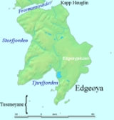
 Edgeøya is located at geographical co-ordinates 77°40′N 22°30′E. To the west lies Storfjorden, which separates Edgeøya from Spitsbergen
. To the north, the sound
known as Freemansundet
lies between Edgeøya and Barentsøya
. In the northeast, Olgastretet separates Edgeøya from Kong Karls Land
. Minor island groups lay to the east (Ryke Yseøyane
) and to the south (Tusenøyane
). The island's south coast in indented by its largest fjord
, Tjuvfjorden
. The island's northernmost point is Kapp Heuglin, a cape
named in August 1870 for the German
explorer Theodor von Heuglin
(1824–76), during the Heuglin-Zeil expedition.
Geologically
, the island resembles central Spitsbergen, with Mesozoic
rocks (specifically, Triassic
shale
s with subordinate sandstone
s, with occasional diabase
intrusions, and, in the southwest, strata
from the Jurassic
), the effects of glacial erosion
, and appearance of polar ice cap
s. On the eastern side of the island is the large glacier of Edgeøyjøkulen
.
Along with Barentsøya and some of the neighbouring islands, Edgeøya forms part of South East Svalbard Nature Reserve, established by the Norwegian government in 1973. There is a significant reindeer population, and the island is an important site for polar bear
reproduction
; moreover, the polar bear population in this Barents Sea area is a unique deme
(unique genetic population).
Norway
Norway , officially the Kingdom of Norway, is a Nordic unitary constitutional monarchy whose territory comprises the western portion of the Scandinavian Peninsula, Jan Mayen, and the Arctic archipelago of Svalbard and Bouvet Island. Norway has a total area of and a population of about 4.9 million...
island
Island
An island or isle is any piece of sub-continental land that is surrounded by water. Very small islands such as emergent land features on atolls can be called islets, cays or keys. An island in a river or lake may be called an eyot , or holm...
in southeast of the Svalbard
Svalbard
Svalbard is an archipelago in the Arctic, constituting the northernmost part of Norway. It is located north of mainland Europe, midway between mainland Norway and the North Pole. The group of islands range from 74° to 81° north latitude , and from 10° to 35° east longitude. Spitsbergen is the...
archipelago
Archipelago
An archipelago , sometimes called an island group, is a chain or cluster of islands. The word archipelago is derived from the Greek ἄρχι- – arkhi- and πέλαγος – pélagos through the Italian arcipelago...
; it is the third largest island in this archipelago. An Arctic
Arctic
The Arctic is a region located at the northern-most part of the Earth. The Arctic consists of the Arctic Ocean and parts of Canada, Russia, Greenland, the United States, Norway, Sweden, Finland, and Iceland. The Arctic region consists of a vast, ice-covered ocean, surrounded by treeless permafrost...
island, it forms part of the South East Svalbard Nature Reserve, home to polar bear
Polar Bear
The polar bear is a bear native largely within the Arctic Circle encompassing the Arctic Ocean, its surrounding seas and surrounding land masses. It is the world's largest land carnivore and also the largest bear, together with the omnivorous Kodiak Bear, which is approximately the same size...
s and reindeer
Reindeer
The reindeer , also known as the caribou in North America, is a deer from the Arctic and Subarctic, including both resident and migratory populations. While overall widespread and numerous, some of its subspecies are rare and one has already gone extinct.Reindeer vary considerably in color and size...
. Its eastern side is covered by an ice field
Ice field
An ice field is an area less than 50,000 km² of ice often found in the colder climates and higher altitudes of the world where there is sufficient precipitation. It is an extensive area of interconnected valley glaciers from which the higher peaks rise as nunataks...
. The island is 5073 square kilometres (1,958.7 sq mi) in area, making it the third largest in the Svalbard archipelago. The island is named after Thomas Edge
Thomas Edge
Thomas Edge was an English merchant, whaler, and sealer who worked for the Muscovy Company in the first quarter of the 17th century. Edge was born in the parish of Blackburn, Lancashire in 1587/88. His father was Ellis Edge. Edgeøya is named after him...
(died 1624), an English
England
England is a country that is part of the United Kingdom. It shares land borders with Scotland to the north and Wales to the west; the Irish Sea is to the north west, the Celtic Sea to the south west, with the North Sea to the east and the English Channel to the south separating it from continental...
merchant and whaler
Whaling
Whaling is the hunting of whales mainly for meat and oil. Its earliest forms date to at least 3000 BC. Various coastal communities have long histories of sustenance whaling and harvesting beached whales...
. It is seldom visited today.
History
The history of Edgeøya's discovery has been a matter of dispute. Thomas Edge, writing in 1622, claimed the island was discovered by one of his ships in 1616. However, Joris CarolusJoris Carolus
Joris Carolus was a Dutch cartographer and explorer. He served for both the Noordsche Compagnie and the Vereenigde Oost-Indische Compagnie .-Career:...
, in a map published in 1614 and allegedly based on discoveries made by him the same year, shows what appears to be Edgeøya's south coast. Carolus showed the coastline split into two parts: "Onbekende Cust" (meaning "Unknown Coast" in Dutch) in the west, and "Morfyn" in the east. Islands are shown offshore of Morfyn. Martin Conway argued in 1901 that Carolus' chart indicated he discovered Edgeøya, but, as Wielder points out, Conway was ignorant of a map (engraved in 1612) by the Dutch
Netherlands
The Netherlands is a constituent country of the Kingdom of the Netherlands, located mainly in North-West Europe and with several islands in the Caribbean. Mainland Netherlands borders the North Sea to the north and west, Belgium to the south, and Germany to the east, and shares maritime borders...
cartographer Petrus Plancius
Petrus Plancius
Petrus Plancius was a Dutch astronomer, cartographer and clergyman. He was born as Pieter Platevoet in Dranouter, now in Heuvelland, West Flanders. He studied theology in Germany and England...
, which illustrated a coastline to the east of Spitsbergen. The coastline, indented, with islands offshore, was labelled "Gerrits Eylant". Wielder believed this to be the first record of Edgeøya's south coast.
Schilder, an expert on Dutch cartography, said Carolus merely copied both coastlines from earlier charts, while he believed that Plancius had copied some names from a chart by Mouris Willemsz, unknown to Wielder, that was published in 1608 or earlier by Cornelis Claeszoon (British Library, London). Willemsz's chart, which Schilder says shows Edgeøya labeled as "Groen Landt", doesn't show Edgeøya at all, but only shows a single coastline (not two) that is supposed to represent Spitsbergen. In fact, what appears to be Bjørnøya is shown to the southeast of Spitsbergen. Plancius had thus only created a duplicate Spitsbergen. Carolus, as well, made a duplicate Spitsbergen, as his Morfyn has an uncanny resemblance to Willemsz's Groen Landt. This would indicate that the island would not have been discovered until 1616, as claimed by Edge. A 1617 letter written between the English whalers proves that Europeans had discovered the island at least at that late of date, or earlier, as Edge claims.
Four Russian sailors were marooned on Edgeøya, or a small island off the coast of Edgeøya, from 1743 until September 1749. Three survived to tell an epic tale of survival. Author David Roberts
David Roberts (climber)
David Roberts is a climber, mountaineer, and author of books and articles about climbing. He is particularly noted for his books The Mountain of My Fear and Deborah: A Wilderness Narrative, chronicling major ascents in Alaska in the 1960s, which had a major impact on the form of mountaineering...
wrote a book about his research on this story, Four Against The Arctic. He concluded, although not definitively, that the men were probably on a small island to the southeast of Edgeøya called Halvmåneøya
Halvmåneøya
Halvmåneøya is a small, uninhabited island off the southeastern coast of Edgeøya, part of the Svalbard archipelago. Halvmåneøya, as part of Edgeøya, has been a nature preserve since 1973, and visitation is strictly regulated....
, or Half Moon Island.
While no major settlement grew upon Edgeøya, whaling and walrus
Walrus
The walrus is a large flippered marine mammal with a discontinuous circumpolar distribution in the Arctic Ocean and sub-Arctic seas of the Northern Hemisphere. The walrus is the only living species in the Odobenidae family and Odobenus genus. It is subdivided into three subspecies: the Atlantic...
hunting
Hunting
Hunting is the practice of pursuing any living thing, usually wildlife, for food, recreation, or trade. In present-day use, the term refers to lawful hunting, as distinguished from poaching, which is the killing, trapping or capture of the hunted species contrary to applicable law...
were extensive industries in the area. Remains of these can be found offshore of Edgeøya, on Bölscheøya
Bölscheøya
Bölscheøya is an island southwest of Negerpynten, the southeastern point of Edgeøya. It is part of Tusenøyane. The island was named in 1868 by the German geographer August Petermann after the German journalist Carl Bölsche, father of the German writer and zoologist Wilhelm Bölsche...
in the Tusenøyane
Tusenøyane
Tusenøyane is a group of small islands south of Edgeøya. They form part of the Svalbard archipelago. The group consists of over forty islands and islets, including Brotskjer, Kulstadholmane, Utsira, Tufsen, Kong Ludvigøyane, Bölscheøya, Hornøya, Tiholmane, Meinickeøyane, Sletteøya, Schareholmane,...
group.
Geography and ecology
Spitsbergen
Spitsbergen is the largest and only permanently populated island of the Svalbard archipelago in Norway. Constituting the western-most bulk of the archipelago, it borders the Arctic Ocean, the Norwegian Sea and the Greenland Sea...
. To the north, the sound
Sound (geography)
In geography a sound or seaway is a large sea or ocean inlet larger than a bay, deeper than a bight and wider than a fjord; or it may be defined as a narrow sea or ocean channel between two bodies of land ....
known as Freemansundet
Freemansundet
Freemansundet is the sound separating Barentsøya to the north from Edgeøya. It is named after Alderman Ralph Freeman, who was involved in the English whaling trade in the early 17th century...
lies between Edgeøya and Barentsøya
Barentsøya
Barents Island is one of the smaller islands in the Svalbard archipelago, lying between Edge Island and Spitsbergen. Barents Island has no permanent human inhabitants. Named for the Dutch explorer Willem Barents , it is a part of Norway.An Arctic island, around 43 per cent its area of is glaciated...
. In the northeast, Olgastretet separates Edgeøya from Kong Karls Land
Kong Karls Land
Kong Karls Land or King Charles Land is an island group in the Svalbard archipelago, in Arctic Ocean. The island group covers an area of and is made up of the islands of Kongsøya, Svenskøya, Abeløya, Helgolandøya and Tirpitzøya....
. Minor island groups lay to the east (Ryke Yseøyane
Ryke Yseøyane
Ryke Yseøyane is a group of several small islands off the east coast of Edgeøya. The islands are named after the Dutch whaler Ryke Yse of Vlieland, who discovered them about 1640-45. The group was first marked by Hendrick Doncker, of Amsterdam, in 1663....
) and to the south (Tusenøyane
Tusenøyane
Tusenøyane is a group of small islands south of Edgeøya. They form part of the Svalbard archipelago. The group consists of over forty islands and islets, including Brotskjer, Kulstadholmane, Utsira, Tufsen, Kong Ludvigøyane, Bölscheøya, Hornøya, Tiholmane, Meinickeøyane, Sletteøya, Schareholmane,...
). The island's south coast in indented by its largest fjord
Fjord
Geologically, a fjord is a long, narrow inlet with steep sides or cliffs, created in a valley carved by glacial activity.-Formation:A fjord is formed when a glacier cuts a U-shaped valley by abrasion of the surrounding bedrock. Glacial melting is accompanied by rebound of Earth's crust as the ice...
, Tjuvfjorden
Tjuvfjorden
Tjuvfjorden is a 45 km long and up to 30 km wide fjord separating Edgeøya’s two southern promontories., Kvalpynten and Negerpyten ....
. The island's northernmost point is Kapp Heuglin, a cape
Headlands and bays
Headlands and bays are two related features of the coastal environment.- Geology and geography :Headlands and bays are often found on the same coastline. A bay is surrounded by land on three sides, whereas a headland is surrounded by water on three sides. Headlands are characterized by high,...
named in August 1870 for the German
Germany
Germany , officially the Federal Republic of Germany , is a federal parliamentary republic in Europe. The country consists of 16 states while the capital and largest city is Berlin. Germany covers an area of 357,021 km2 and has a largely temperate seasonal climate...
explorer Theodor von Heuglin
Theodor von Heuglin
Martin Theodor von Heuglin , was a German explorer and ornithologist.-Biography:...
(1824–76), during the Heuglin-Zeil expedition.
Geologically
Geology
Geology is the science comprising the study of solid Earth, the rocks of which it is composed, and the processes by which it evolves. Geology gives insight into the history of the Earth, as it provides the primary evidence for plate tectonics, the evolutionary history of life, and past climates...
, the island resembles central Spitsbergen, with Mesozoic
Mesozoic
The Mesozoic era is an interval of geological time from about 250 million years ago to about 65 million years ago. It is often referred to as the age of reptiles because reptiles, namely dinosaurs, were the dominant terrestrial and marine vertebrates of the time...
rocks (specifically, Triassic
Triassic
The Triassic is a geologic period and system that extends from about 250 to 200 Mya . As the first period of the Mesozoic Era, the Triassic follows the Permian and is followed by the Jurassic. Both the start and end of the Triassic are marked by major extinction events...
shale
Shale
Shale is a fine-grained, clastic sedimentary rock composed of mud that is a mix of flakes of clay minerals and tiny fragments of other minerals, especially quartz and calcite. The ratio of clay to other minerals is variable. Shale is characterized by breaks along thin laminae or parallel layering...
s with subordinate sandstone
Sandstone
Sandstone is a sedimentary rock composed mainly of sand-sized minerals or rock grains.Most sandstone is composed of quartz and/or feldspar because these are the most common minerals in the Earth's crust. Like sand, sandstone may be any colour, but the most common colours are tan, brown, yellow,...
s, with occasional diabase
Diabase
Diabase or dolerite is a mafic, holocrystalline, subvolcanic rock equivalent to volcanic basalt or plutonic gabbro. In North American usage, the term diabase refers to the fresh rock, whilst elsewhere the term dolerite is used for the fresh rock and diabase refers to altered material...
intrusions, and, in the southwest, strata
Stratum
In geology and related fields, a stratum is a layer of sedimentary rock or soil with internally consistent characteristics that distinguish it from other layers...
from the Jurassic
Jurassic
The Jurassic is a geologic period and system that extends from about Mya to Mya, that is, from the end of the Triassic to the beginning of the Cretaceous. The Jurassic constitutes the middle period of the Mesozoic era, also known as the age of reptiles. The start of the period is marked by...
), the effects of glacial erosion
Erosion
Erosion is when materials are removed from the surface and changed into something else. It only works by hydraulic actions and transport of solids in the natural environment, and leads to the deposition of these materials elsewhere...
, and appearance of polar ice cap
Polar ice cap
A polar ice cap is a high latitude region of a planet or natural satellite that is covered in ice. There are no requirements with respect to size or composition for a body of ice to be termed a polar ice cap, nor any geological requirement for it to be over land; only that it must be a body of...
s. On the eastern side of the island is the large glacier of Edgeøyjøkulen
Edgeøyjøkulen
Edgeøyjøkulen is an ice cap glacier on the island Edgeøya of the archipelago Svalbard, Norway. The glacier covers and area of about ....
.
Along with Barentsøya and some of the neighbouring islands, Edgeøya forms part of South East Svalbard Nature Reserve, established by the Norwegian government in 1973. There is a significant reindeer population, and the island is an important site for polar bear
Polar Bear
The polar bear is a bear native largely within the Arctic Circle encompassing the Arctic Ocean, its surrounding seas and surrounding land masses. It is the world's largest land carnivore and also the largest bear, together with the omnivorous Kodiak Bear, which is approximately the same size...
reproduction
Biological reproduction
Reproduction is the biological process by which new "offspring" individual organisms are produced from their "parents". Reproduction is a fundamental feature of all known life; each individual organism exists as the result of reproduction...
; moreover, the polar bear population in this Barents Sea area is a unique deme
Deme
In Ancient Greece, a deme or demos was a subdivision of Attica, the region of Greece surrounding Athens. Demes as simple subdivisions of land in the countryside seem to have existed in the 6th century BC and earlier, but did not acquire particular significance until the reforms of Cleisthenes in...
(unique genetic population).
In popular culture
Edgeøya is the setting for the novel The Solitude of Thomas Cave (2007), by Georgina Harding, in which the title character, on a wager, successfully over-winters on the island in 1616-17.See also
- List of islands of Norway