
Ecoregions of Zambia
Encyclopedia
The biomes and ecoregions in the ecology of Zambia are described, listed and mapped here, following the World Wildlife Fund's Global 200
classification scheme for terrestrial ecoregions, and the WWF freshwater
bioregion classification for rivers, lakes and wetlands.
Zambia is in the Afrotropic biogeographic realm (or ecozone) of the scheme. Three terrestrial biomes are well-represented in the country (with an additional one extending a few kilometres over the border).
The distribution of the biomes and ecoregions is governed mainly by the physical environment, especially climate
.
, and temperature
, which is related to elevation
; and soil
s and bushfires.
is over the country. The highest rainfall is in the north (about 1200 mm –- all figures are annual amounts), especially the north-west (1400 mm), decreasing towards the south (around 700 mm); the driest areas are in the Luangwa and middle Zambezi valleys (500 mm). None of the country is arid.
Elsewhere, plants and animals are adapted to the long dry season. For plants this includes the deciduous habit (losing leaves to conserve water), very deep root systems, water-storing roots and tubers, waxy leaf cuticles, and drought-resistant seeds. Succulent plants are also widespread, especially in rocky areas. For animals, adaptations to drought are seen in migration and breeding patterns, as well as the ability, found in rodents and reptiles especially, to obtain water requirements from food without the need to drink. Hibernation through the dry season is practised by some amphibians and invertebrates. The latter may also survive the dry season through drought-resistant forms.
Temperatures are higher at lower elevations, such as the Luapula-Mweru and Mweru-Wantipa/Tanganyika valleys in the north, and highest in the lower Luangwa and Zambezi valleys in the south, typically experiencing 40°C in October.
One way in which temperature affects the distribution of large mammals is through the distribution of the tsetse fly
, which, within its range is found in hotter valleys rather than the higher, cooler plateau. Species susceptible to trypanosomiasis
are not found in such valleys.
In areas where soils are waterlogged for all or part of the year, or are very infertile, sandy or acidic, they take over from climate as the predominant factor in determining the distribution of plants and animals. Such communities are said to be edaphic
, and are found on grey dambo soils, black floodplain soils and Kalahari sands.
" and caused by villagers burning off crop residue or hunting, as well as by lightning strikes. The vegetation is adapted to it, particularly the grasses, and at that time of the year deciduous trees have lost most of their leaves and so do not suffer damage. Prevailing winds are not usually very strong and a lack of a great deal of dry fuel on the ground (since most areas are burnt annually it does not build up) means that the fires are not as devastating as in countries such as Australia and the south-western USA.
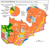
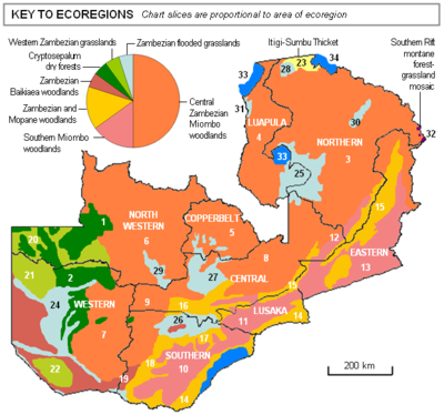 Rough estimates of the percentage of the country covered as given below are for the original or natural state of the area before urbanisation and agriculture has modified it. The numbers relate to the location labels on the map.
forest of medium height on sandy soils with little to no surface water, in several patches which make up the largest evergreen forest in Africa outside of the equatorial zone. The dominant genus, Cryptosepalum, is a tree in the legume family. The lack of water and thickness of the forest has kept the human population low, and despite some poaching and the absence of protection, the forest is still fairly rich in wildlife. The main patches are in:
trees (Brachystegia sp.), a member of the legume family. This ecoregion predominates in the wettest part of the country, across the northern part of both 'lobes' of the country . On the flat central African plateau the woodland is interspersed with dambo
s, grassy wetlands forming the headwaters and margins of rivers which may make up to 30% of the ecoregion and which increase biodiversity of the ecoregion. The ecoregion has suffered extensive deforestation, especially in the highly-urbanised Copperbelt Province due to charcoal production and clearing for farming, the centre of Central Province (for farming and ranching), and around Kasama and Mansa (charcoal production and chitemene
farming). It covers:
, and it found is in only location anywhere else, an equally small area of central Tanzania (Itigi). It comprises an almost impenetrable bush consisting of about a hundred plant species woven together so densely that it is virtually impossible to walk through. Around 70% of the Zambian thicket has been lost to land clearing and at the present rate the rest will vanish within 20 years. It is found:
Zambezi Basin made up of (not shown on the map):
Global 200
The Global 200 is the list of ecoregions identified by the World Wildlife Fund as priorities for conservation. According to the WWF, an ecoregion is defined as a "relatively large unit of land or water containing a characteristic set of natural communities that share a large majority of their...
classification scheme for terrestrial ecoregions, and the WWF freshwater
Freshwater
Fresh water is naturally occurring water on the Earth's surface in ice sheets, ice caps, glaciers, bogs, ponds, lakes, rivers and streams, and underground as groundwater in aquifers and underground streams. Fresh water is generally characterized by having low concentrations of dissolved salts and...
bioregion classification for rivers, lakes and wetlands.
Zambia is in the Afrotropic biogeographic realm (or ecozone) of the scheme. Three terrestrial biomes are well-represented in the country (with an additional one extending a few kilometres over the border).
The distribution of the biomes and ecoregions is governed mainly by the physical environment, especially climate
Climate
Climate encompasses the statistics of temperature, humidity, atmospheric pressure, wind, rainfall, atmospheric particle count and other meteorological elemental measurements in a given region over long periods...
.
Physical environment
The main aspects of the physical environment which determine the biomes and ecoregions of Zambia are: climate, specifically rainfall amount, length of the dry seasonDry season
The dry season is a term commonly used when describing the weather in the tropics. The weather in the tropics is dominated by the tropical rain belt, which oscillates from the northern to the southern tropics over the course of the year...
, and temperature
Temperature
Temperature is a physical property of matter that quantitatively expresses the common notions of hot and cold. Objects of low temperature are cold, while various degrees of higher temperatures are referred to as warm or hot...
, which is related to elevation
Elevation
The elevation of a geographic location is its height above a fixed reference point, most commonly a reference geoid, a mathematical model of the Earth's sea level as an equipotential gravitational surface ....
; and soil
Soil
Soil is a natural body consisting of layers of mineral constituents of variable thicknesses, which differ from the parent materials in their morphological, physical, chemical, and mineralogical characteristics...
s and bushfires.
Rainfall
Rainfall amount is the most important determinant of the type and distribution of ecoregions. Zambia experiences good rainfall, extremes of 500 to 1400 mm (most areas fall into the range 700 to ) in a distinct rainy season of four to six months centred on January, when the moist intertropical convergence zoneIntertropical Convergence Zone
The Intertropical Convergence Zone , known by sailors as The Doldrums, is the area encircling the earth near the equator where winds originating in the northern and southern hemispheres come together....
is over the country. The highest rainfall is in the north (about 1200 mm –- all figures are annual amounts), especially the north-west (1400 mm), decreasing towards the south (around 700 mm); the driest areas are in the Luangwa and middle Zambezi valleys (500 mm). None of the country is arid.
Dry season and drought resistance
The dry season lasts 6–8 months, divided into the cool dry season or winter from April or May to August, followed by the hot dry season, September to November. Most rivers, lakes and swamps are permanent, except in the hotter, drier south. Along the banks of permanent rivers and in the spray of waterfalls are evergreen thickets similar in character to tropical rainforest, relics of a wetter past. In dambos (grasslands found in most of the country) and other marshes, soil water is available throughout the dry season, but they may be rather acidic.Elsewhere, plants and animals are adapted to the long dry season. For plants this includes the deciduous habit (losing leaves to conserve water), very deep root systems, water-storing roots and tubers, waxy leaf cuticles, and drought-resistant seeds. Succulent plants are also widespread, especially in rocky areas. For animals, adaptations to drought are seen in migration and breeding patterns, as well as the ability, found in rodents and reptiles especially, to obtain water requirements from food without the need to drink. Hibernation through the dry season is practised by some amphibians and invertebrates. The latter may also survive the dry season through drought-resistant forms.
Temperature and elevation
The elevation of the great central African plateau on which Zambia is located, typically between 1000 and 1300 metres, modifies temperatures, which are lower than for coastal areas at the same latitude, and pleasant for much of the year. On the plateau (covering about 80% of the country) mean minimums for June in the cool dry season are in the range 6–12°C, mean maximums for October, the hot dry season are 28–35°C. Frost only occurs on a few days in winter on the highest exposed hills, or more widely in the lower humidity areas of the southern half of the country. Plants susceptible to frost do not grow in the southern half of the country. Otherwise temperature by itself is not a great determinant of plant and animal distribution.Temperatures are higher at lower elevations, such as the Luapula-Mweru and Mweru-Wantipa/Tanganyika valleys in the north, and highest in the lower Luangwa and Zambezi valleys in the south, typically experiencing 40°C in October.
One way in which temperature affects the distribution of large mammals is through the distribution of the tsetse fly
Tsetse fly
Tsetse , sometimes spelled tzetze and also known as tik-tik flies, are large biting flies that inhabit much of mid-continental Africa between the Sahara and the Kalahari deserts. They live by feeding on the blood of vertebrate animals and are the primary biological vectors of trypanosomes, which...
, which, within its range is found in hotter valleys rather than the higher, cooler plateau. Species susceptible to trypanosomiasis
Trypanosomiasis
Trypanosomiasis or trypanosomosis is the name of several diseases in vertebrates caused by parasitic protozoan trypanosomes of the genus Trypanosoma. Approximately 500,000 men, women and children in 36 countries of sub-Saharan Africa suffer from human African trypanosomiasis which is caused by...
are not found in such valleys.
Soils
The broad types of soil found in Zambia are:- red sandveld soils cover most of the country, and are generally not very fertile due to weathering and leaching; the top soil is sandy and is more fertile where the top soil has a higher clay content.
- Grey dambo soils contain more nutrients but are waterlogged in the rainy season and often very acidic, restricting the plants which can grow there to sedges and wiry grasses tolerant of marshy conditions.
- Black soils of floodplains are fertile, grasses grow on them as soon as the annual flood recedes and provide a rich resource for herbivores. If the annual flood is disrupted by dams, woody shrubs of lower nutritional value tend to replace grasses and so reduce the number of herbivores and biodiversity.
- Kalahari Sands in the south-west of the country are infertile and do not retain moisture, so are dominated mostly by deep-rooted trees with little growth in the understorey. Grasslands both flooded and non-flooded also occur there .
In areas where soils are waterlogged for all or part of the year, or are very infertile, sandy or acidic, they take over from climate as the predominant factor in determining the distribution of plants and animals. Such communities are said to be edaphic
Edaphic
Edaphic is a nature related to soil. Edaphic qualities may characterize the soil itself, including drainage, texture, or chemical properties such as pH. Edaphic may also characterize organisms, such as plant communities, where it specifies their relationships with soil...
, and are found on grey dambo soils, black floodplain soils and Kalahari sands.
Bush fires
Bush fires range across most of the country in the later dry season, escaping from "chitemene cultivationChitemene
Chitemene , from the ciBemba word meaning “place where branches have been cut for a garden”, is a system of slash and burn agriculture practiced throughout northern Zambia...
" and caused by villagers burning off crop residue or hunting, as well as by lightning strikes. The vegetation is adapted to it, particularly the grasses, and at that time of the year deciduous trees have lost most of their leaves and so do not suffer damage. Prevailing winds are not usually very strong and a lack of a great deal of dry fuel on the ground (since most areas are burnt annually it does not build up) means that the fires are not as devastating as in countries such as Australia and the south-western USA.
Terrestrial biomes
Tropical and subtropical dry broadleaf forests biome
In Zambia this biome is represented by only one ecoregion in a few patches, covering around 5% of the land area.Zambezian Cryptosepalum dry forests
Quite dense evergreenEvergreen
In botany, an evergreen plant is a plant that has leaves in all seasons. This contrasts with deciduous plants, which completely lose their foliage during the winter or dry season.There are many different kinds of evergreen plants, both trees and shrubs...
forest of medium height on sandy soils with little to no surface water, in several patches which make up the largest evergreen forest in Africa outside of the equatorial zone. The dominant genus, Cryptosepalum, is a tree in the legume family. The lack of water and thickness of the forest has kept the human population low, and despite some poaching and the absence of protection, the forest is still fairly rich in wildlife. The main patches are in:
- 1 —West Lunga National ParkWest Lunga National ParkWest Lunga National Park is a remote wildlife haven in dense forest in the North-Western Province of Zambia. It lies between the West Lunga River and Kabompo River about 10 km north of the gravel road from Solwezi to Kabompo, and covers about 1700 km²....
, North Western Province, stretching south-west to the Kabompo RiverKabompo RiverThe Kabompo River is one of the main tributaries of the upper Zambezi River river. It flows entirely in Zambia, rising to the east of the source of the Zambezi, in North-Western Province along the watershed between the Zambezi and Congo river basins which also forms the border between Zambia and DR...
–Zambezi River confluence. - 2 —Western ProvinceWestern Province, ZambiaWestern Province, encompasses the area formerly known as Barotseland in the colonial era.-Districts:Western Province is divided into 7 districts:*Kalabo District*Kaoma District*Lukulu District*Mongu District*Senanga District*Sesheke District...
between the Kabompo and Luena RiversLuena River, Western ZambiaThe Luena River of Zambia's Western Province rises just west of the Kafue National Park and flows west through Kaoma to become a tributary of the Zambezi. In the dry season, just below its confluence with its seasonal tributary the Luampa River, it ends in swamps or marshes on the Luena Flats east...
Tropical and subtropical grasslands, savannas, and shrublands biome
Most of Zambia (around 80%) is in this extensive biome. Six ecoregions are represented of which the first four listed below are woodland savannas, consisting of a grass cover 1–2 m high, and hardwood deciduous trees and/or hardwood shrubs, which range in ground coverage from 'scattered' to 'abundant'. Leguminous tree species dominate, which are deciduous, losing leaves in the dry season and producing a flush of new leaves, often reddish, just before the onset of the rains. In higher rainfall areas of Zambia the proportion and size of trees are at the higher extreme for this biome, with a canopy covering up to 40% of the ground and trees often exceeding 10 m in height. However, except in the case of the last ecoregion listed, even where the canopy is extensive, at ground level the woodland is relatively open, affording quite easy passage by animals and people.Central Zambezian Miombo woodlands
The most extensive ecoregion covering about 50% of the country, characterised by MiomboMiombo
Miombo is the Swahili word for Brachystegia, a genus of tree comprising a large number of species. Miombo woodland is classified in the tropical and subtropical grasslands, savannas, and shrublands biome...
trees (Brachystegia sp.), a member of the legume family. This ecoregion predominates in the wettest part of the country, across the northern part of both 'lobes' of the country . On the flat central African plateau the woodland is interspersed with dambo
Dambo
Dambo is a word used for a class of complex shallow wetlands in central, southern and eastern Africa, particularly in Zambia and Zimbabwe. They are generally found in higher rainfall flat plateau areas, and have river-like branching forms which may be nowhere very large, but common enough to add up...
s, grassy wetlands forming the headwaters and margins of rivers which may make up to 30% of the ecoregion and which increase biodiversity of the ecoregion. The ecoregion has suffered extensive deforestation, especially in the highly-urbanised Copperbelt Province due to charcoal production and clearing for farming, the centre of Central Province (for farming and ranching), and around Kasama and Mansa (charcoal production and chitemene
Chitemene
Chitemene , from the ciBemba word meaning “place where branches have been cut for a garden”, is a system of slash and burn agriculture practiced throughout northern Zambia...
farming). It covers:
- 3 —Northern ProvinceNorthern Province, ZambiaNorthern Province is one of Zambia's nine provinces. It covers approximately one fifth of Zambia in land area. The provincial capital is Kasama. The province is made up of 12 districts, namely Kasama , Chilubi, Isoka, Chinsali, Kaputa, Luwingu, Mbala, Mporokoso, Mpika, Mpulungu, Mungwi and Nakonde...
except flooded grassland areas and Luangwa valleyLuangwa RiverThe Luangwa River is one of the major tributaries of the Zambezi River, and one of the four biggest rivers of Zambia. The river generally floods in the rainy season and then falls considerably in the dry season...
slopes - 4 —Luapula ProvinceLuapula ProvinceLuapula Province is one of Zambia's nine provinces, and is located in the north of the country. The provincial capital is Mansa. Luapula Province was named after the Luapula River....
except flooded grassland areas - 5 —Copperbelt ProvinceCopperbelt ProvinceCopperbelt Province in Zambia covers the mineral-rich Copperbelt, and farming and bush areas to the south. It was the backbone of the Northern Rhodesian economy during British colonial rule and fuelled the hopes of the immediate post-independence period, but its economic importance was severely...
except for flooded grassland areas in the south-west. - 6 —North Western Province except the Busanga area and far west
- 7 —the eastern part of Western Province
- 8 —northern parts of Central ProvinceCentral Province, ZambiaCentral Province is one of Zambia's nine provinces. The provincial capital is Kabwe, home of the Mulungushi Rock of Authority, founder home of UNIP, the ruling political party in the second republic ....
- 9 —Kafue National ParkKafue National ParkKafue National Park is the largest national park in Zambia, covering an area of about 22,400 km² . It is the second largest park in Africa and is home to over 55 different species of animals....
in Central and Southern Provinces, except the north-west corner (Busanga Swamps and plain) in North West Province.(also the western part)
Southern Miombo woodlands
Covering about 15% of the country in the south, and dryer than the Central Zambezian ecoregion, trees in this ecoregion are more scattered and generally smaller, and the relative proportion of woody shrubs is greater. Dambos are fewer. Much of the ecoregion in Southern Province (sometimes referred to as the Southern Plateau) and the south-east of Eastern Province (sometimes referred to as the Eastern Plateau) has been cleared for farming and ranching. The main sites are:- 10 —the Southern Plateau in Southern ProvinceSouthern Province, ZambiaSouthern Province is one of Zambia's nine provinces, and home to Zambia's premier tourist attraction, Mosi-oa-Tunya , shared with Zimbabwe...
(the largest commercial farming area of the country) - 11 —Lusaka ProvinceLusaka ProvinceLusaka Province is one of Zambia's nine provinces. The provincial capital is Lusaka, which is also the national capital.-National Parks and wildlife areas:*Lower Zambezi National Park...
except areas close to the Zambezi, Lunsemfwa and Kafue rivers - 12 —the Muchinga escarpment in Central and Northern Provinces
- 13 —most of Eastern ProvinceEastern Province, ZambiaEastern Province is one of Zambia's nine provinces. The province lies between the Luangwa River and the border with Malawi, from Isoka in the northeast to just north of Luangwa in the south.The provincial capital is Chipata...
except the bottom of the Luangwa Valley and a patch of plateau around PetaukePetaukePetauke is a town and seat of Petauke District located in the Eastern Province of Zambia.Petauke is 400 km from the capital city Lusaka, roughly halfway between Lusaka and the Malawi border...
Zambezian and Mopane woodlands
The Mopane tree Colophospermum mopane is also a legume and grows in hotter locations than the miombo species, and so Mopane woodlands, covering about 15% of the country, replace southern miombo woodlands at lower elevations in valleys in the south of the country, principally:- 14 —along the Zambezi and KaribaKaribaKariba is a town in Mashonaland West province, Zimbabwe, located close to the Kariba Dam at the northwestern end of Lake Kariba, near the Zambian border. According to the 1992 Population Census, the town had a population of 20,736....
valleys east of the Caprivi StripCaprivi StripCaprivi, sometimes called the Caprivi Strip , Caprivi Panhandle or the Okavango Strip and formally known as Itenge, is a narrow protrusion of Namibia eastwards about , between Botswana to the south, Angola and Zambia to the north, and Okavango Region to the west. Caprivi is bordered by the...
, southern part of Lusaka Province and Lower Zambezi National Park - 15 —along the bottom of the Lunsemfwa and Luangwa valleys including NorthNorthNorth is a noun, adjective, or adverb indicating direction or geography.North is one of the four cardinal directions or compass points. It is the opposite of south and is perpendicular to east and west.By convention, the top side of a map is north....
and South Luangwa National ParkSouth Luangwa National ParkSouth Luangwa National Park in eastern Zambia, the southernmost of three national parks in the valley of the Luangwa River, is a world-renowned wildlife haven. It supports large populations of Thornicroft's Giraffe, and herds of elephant and buffalo often several hundred strong, while the Luangwa...
s closer to the river - 16 —in a strip running north of the Kafue Flats in Central Province
- 17 —in a strip running south of the Kafue Flats in Southern Province
- 18 —in a strip running from the Kafue Flats to the Caprivi Strip
Zambezian Baikiaea woodlands
This ecoregion, covering about 5% of Zambia in the south-west, is dominated by Baikiaea plurijuga, Zambian teak. It is well adapted to hot dry areas on sandy soils, and forms extensive forests which have been over-exploited by commercial timber production over the past 75 years, in:- 19 —southern part of Western Province and south-west of Southern Province (MulobeziMulobeziMulobezi is a small town in the Southern Province of Zambia, and the centre of its timber industry. Timber extends into Southern Province with which the town is economically linked....
teak forests), and the sandy plains west and south west of the Barotse floodplain, interspersed with grasslands.
Western Zambezian grasslands
These are the most extensive non-floodplain grasslands in Zambia, covering about 5% of the country in the west, and support large herds of wildebeest which migrate between western Zambia and Angola. They are found:- 20 —Patches in the extreme west of North Western Province, north-west of the Kabompo and Lungwebungu Rivers
- 21 —Liuwa Plain National ParkLiuwa Plain National ParkThe Liuwa Plain National Park lies in Western Province, Zambia, west of the Barotse Floodplain of the Zambezi River near the border with Angola.-History:...
in Western Province north-west of the Barotse floodplain (Zambezi River) - 22 —Plains within Sioma Ngwezi National ParkSioma Ngwezi National ParkSioma Ngwezi National Park is a 5000-square-kilometre park in the very south west corner of Zambia. It is undeveloped and rarely visited, lacking roads and being off the usual tourist tracks, but this may change in the future....
in Western and North-Western provinces.
Itigi-Sumbu thicket
This endangered ecoregion is found in only one small area (less than 1%) of northern Zambia, named after SumbuNsumbu National Park
Sumbu National Park lies on the western shore of Lake Tanganyika near its southern extremity, in Zambia's Northern Province...
, and it found is in only location anywhere else, an equally small area of central Tanzania (Itigi). It comprises an almost impenetrable bush consisting of about a hundred plant species woven together so densely that it is virtually impossible to walk through. Around 70% of the Zambian thicket has been lost to land clearing and at the present rate the rest will vanish within 20 years. It is found:
- 23 —between Lake Mweru WantipaLake Mweru WantipaLake Mweru Wantipa is a lake and swamp system in the Northern Province of Zambia. It has been regarded in the past as something of mystery, displaying fluctuations in water level and salinity which were not entirely explained by variation in rainfall levels; it has been known to dry out almost...
and Lake TanganyikaLake TanganyikaLake Tanganyika is an African Great Lake. It is estimated to be the second largest freshwater lake in the world by volume, and the second deepest, after Lake Baikal in Siberia; it is also the world's longest freshwater lake...
at Nsumbu National ParkNsumbu National ParkSumbu National Park lies on the western shore of Lake Tanganyika near its southern extremity, in Zambia's Northern Province...
Flooded grasslands and savannas biome
This biome is represented by one ecoregion. As a country with very distinct rainy and dry seasons, with a high rainfall in the former, and having a fairly flat topography, Zambian rivers and low-lying areas are prone to flooding, and there are extensive permanent swamps. Around 10% of the country is in this biome and its sole ecoregion. Plants, animals and people have evolved to this cycle which in Zambia has been fairly reliable, and it brings a number of ecological advantages which promote biodiversity. The role of termites in building mounds which remain above most of the flood is important as this provides habitats for plants less tolerant of waterlogging, as well as safe breeding sties for birds and some animals.Zambezian flooded grasslands
The 8 sites listed below form a broad chain running from south-west to north-east. The chain extends into Namibia and Botswana at one end (Caprivi wetlands and Okavango Swamp) and to Tanzania and Kenya at the other. This chain is exploited by birds in their migration and in former times, animals also migrated along the chain. The main sites are:- 24 —Barotse floodplainBarotse FloodplainThe Barotse Floodplain also known as the Bulozi Plain, Lyondo or the Zambezi Floodplain is one of Africa's great wetlands, on the Zambezi River in the Western Province of Zambia...
, Luanginga RiverLuanginga RiverThe Luanginga is a river rising in Angola, which flows into the Zambezi in western Zambia....
floodplain and Luena FlatsLuena River, Western ZambiaThe Luena River of Zambia's Western Province rises just west of the Kafue National Park and flows west through Kaoma to become a tributary of the Zambezi. In the dry season, just below its confluence with its seasonal tributary the Luampa River, it ends in swamps or marshes on the Luena Flats east...
, in Western Province - 25 —Bangweulu Swamps and floodplain, Northern and Luapula Provinces
- 26 —Kafue Flats, Central and Southern Provinces
- 27 —Lukanga SwampLukanga SwampLukanga Swamp is a major wetland in the Central Province of Zambia, about 50 km west of Kabwe. Its permanently swampy area consists of a roughly circular area with a diameter of 40 to 50 km covering 1850 km², plus roughly 250 km² in the mouths of and along rivers discharging...
and floodplains of the Kafue and its tributaries in Central Province and south west Copperbelt Province - 28 —Lake Mweru Wantipa/Mweru Marsh floodplain, Northern Province
- 29 —Busanga Swamps and plain, Kafue National Park, North Western Province
- 30 —Upper Chambeshi RiverChambeshi RiverThe Chambeshi River of northeastern Zambia is the most remote headstream of the Congo River and therefore considered its source...
floodplain, Northern Province - 31 —Luapula Swamps south of Lake MweruLake MweruLake Mweru is a freshwater lake on the longest arm of Africa's second-longest river, the Congo. Located on the border between Zambia and Democratic Republic of the Congo, it makes up 110 km of the total length of the Congo, lying between its Luapula River and Luvua River segments.Mweru...
, Luapula Province
Montane Grasslands and Shrublands biome
This biome covers an area of only about 100 km² on the northern border with Malawi, being an extension of a much larger area in Malawi and Tanzania, and so is frequently not counted as present in Zambia. It lies on plateau above 2000 m elevation, with grassland and shrubland dominating. In Zambia a sole ecoregion within the biome is represented.Southern Rift montane forest-grassland mosaic
This ecoregion is made up of grassland and shrubland, with a great variety of orchids and wildflowers on exposed hills, with forest in narrow valleys and small depressions. It occurs only on:- 32 —Nyika Plateau in the Nyika National ParkNyika National ParkNyika National Park is Malawi’s largest national park, with an area of 3200 km² .-Location and road access:The park covers practically the whole of the Nyika Plateau in northern Malawi, about 480 km north of Lilongwe and 60 km north of Rumphi by road...
, 80 km², and two smaller patches to the north including the Mafinga Hills, on the Malawi border.
Freshwater bioregion
The great freshwater lakes of Tanganyika, Mweru, Bangweulu and Kariba (an artificial reservoir), together with the smaller lakes such as Mweru Wantipa and Itezhi-Tezhi reservoir, and numerous lagoons and swamps cover about 5% of Zambia. Together with their associated rivers, the WWF categorises these freshwater bioregions in Zambia:- 33 —Bangweulu-Mweru, the upper Congo basin containing the Chambeshi River, Lake Bangweulu and its swamps, Luapula River, Lake Mweru and the Kalungwishi River.
- 34 —Lake Tanganyika
Zambezi Basin made up of (not shown on the map):
- Zambezian Headwaters
- Upper Zambezi Floodplains
- Zambezi River
- Kafue River
- Middle Zambezi and Luangwa River
See also
- Climate of ZambiaClimate of ZambiaThe climate of Zambia in Central and Southern Africa is tropical modified by altitude . In the Köppen climate classification, most of the country is classified as humid subtropical or tropical wet and dry, with small patches of semi-arid steppe climate in the south-west.Climate and specifically...
- Geography of ZambiaGeography of ZambiaZambia is a landlocked country located in Southern Africa, to the east of Angola. It has a total area of 752 618 square kilometres , of which 9 220 km² are water.-Political geography:...
- Wildlife of ZambiaWildlife of ZambiaThe wildlife of Zambia refers to the natural flora and fauna of Zambia. This article provides an overview, and outline of the main wildlife areas or regions, and compact lists of animals focussing on prevalence and distribution in the country rather than on taxonomy...
- List of national parks of Zambia