
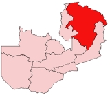
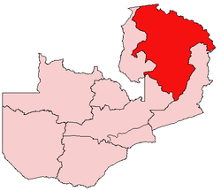
Northern Province, Zambia
Encyclopedia
Zambia
Zambia , officially the Republic of Zambia, is a landlocked country in Southern Africa. The neighbouring countries are the Democratic Republic of the Congo to the north, Tanzania to the north-east, Malawi to the east, Mozambique, Zimbabwe, Botswana and Namibia to the south, and Angola to the west....
's nine provinces
Provinces of Zambia
Zambia is divided into 10 provinces.-References:...
. It covers approximately one fifth of Zambia in land area. The provincial capital is Kasama
Kasama, Zambia
Kasama is the capital of the Northern Province of Zambia, situated on the central-southern African plateau at an elevation of about 1400 m. Its population, according to the 2000 census, is approximately 200,000. It grew considerably in the 1970s and 1980s after construction of the TAZARA Railway...
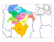
. The province is made up of 12 districts, namely Kasama (the provincial capital), Chilubi
Chilubi District
Chilubi District with headquarters at Chilubi is located in Northern Province, Zambia. It covers the north-east Bangweulu Lake and Bangweulu swamps containing several islands including Chilubi Island, and some of the mainland northeast of the lake...
, Isoka, Chinsali
Chinsali District
Chinsali District with headquarters at Chinsali is located in Northern Province, Zambia.It lies on the watershed between the Chambeshi River in the Congo basin and the Luangwa River in the Zambezi basin...
, Kaputa, Luwingu, Mbala, Mporokoso, Mpika, Mpulungu, Mungwi and Nakonde. Currently, only Kasama and Mbala have attained municipal council status, while the rest are still district councils. It is widely considered to be the heartland of the Bemba, one of the largest tribes in Zambia.
Notable land marks in Northern Province include Lake Tanganyika
Lake Tanganyika
Lake Tanganyika is an African Great Lake. It is estimated to be the second largest freshwater lake in the world by volume, and the second deepest, after Lake Baikal in Siberia; it is also the world's longest freshwater lake...
, Lake Bangweulu
Lake Bangweulu
Bangweulu — 'where the water sky meets the sky' — is one of the world's great wetland systems, comprising Lake Bangweulu, the Bangweulu Swamps and the Bangweulu Flats or floodplain...
, and the corresponding wetlands, Lake Mweru-wa-Ntipa, and a number of waterfalls including Lumangwe Falls
Lumangwe Falls
Lumangwe Falls on the Kalungwishi River in northern Zambia is the largest waterfall wholly within that country, with a height of 30-40 m and a width of 160 m. The falls is 80 km from Mporokoso on the Kawambwa road...
, Kabwelume Falls
Kabwelume Falls
Kabwelume Falls is a waterfall on the Kalungwishi River in the Northern Province of Zambia. The falls is about 6 km down stream of Lumangwe Falls. When viewed at peak water volume , a month after the wet season, the falls makes a spectacular semi circle of falling water. There are plans to build a...
, Chishimba and Kalambo Falls
Kalambo Falls
Kalambo Falls on the Kalambo River is a 772ft single drop waterfall on the border of Zambia and Tanzania at the southeast end of Lake Tanganyika. The falls are some of the tallest uninterrupted falls in Africa...
.
Efforts are being made by the Zambian government, along with a number of non-governmental organizations, to increase the visibility of the many natural and historical treasures in the Northern Province. Tourism has proven an effective way to bring economic growth in other parts of Zambia, i.e. Livingstone
Livingstone, Zambia
Livingstone or Maramba is a historic colonial city and present capital of the Southern Province of Zambia, a tourism centre for the Victoria Falls lying north of the Zambezi River, and a border town with road and rail connections to Zimbabwe on the other side of the Falls...
and Victoria Falls
Victoria Falls
The Victoria Falls or Mosi-oa-Tunya is a waterfall located in southern Africa on the Zambezi River between the countries of Zambia and Zimbabwe.-Introduction:...
. However, a lack of infrastructure along the vast distances between major points of interest makes visiting this part of the country difficult.
Northern Province, with a total area of 147,286 square kilometers, is the largest of Zambia's 9 provinces. It shares borders not only with three other provinces - Central
Central Province, Zambia
Central Province is one of Zambia's nine provinces. The provincial capital is Kabwe, home of the Mulungushi Rock of Authority, founder home of UNIP, the ruling political party in the second republic ....
, Eastern
Eastern Province, Zambia
Eastern Province is one of Zambia's nine provinces. The province lies between the Luangwa River and the border with Malawi, from Isoka in the northeast to just north of Luangwa in the south.The provincial capital is Chipata...
and Luapula
Luapula Province
Luapula Province is one of Zambia's nine provinces, and is located in the north of the country. The provincial capital is Mansa. Luapula Province was named after the Luapula River....
, but also with three countries as well - the Democratic Republic of Congo in the north, Tanzania
Tanzania
The United Republic of Tanzania is a country in East Africa bordered by Kenya and Uganda to the north, Rwanda, Burundi, and the Democratic Republic of the Congo to the west, and Zambia, Malawi, and Mozambique to the south. The country's eastern borders lie on the Indian Ocean.Tanzania is a state...
in the north-east, and Malawi
Malawi
The Republic of Malawi is a landlocked country in southeast Africa that was formerly known as Nyasaland. It is bordered by Zambia to the northwest, Tanzania to the northeast, and Mozambique on the east, south and west. The country is separated from Tanzania and Mozambique by Lake Malawi. Its size...
in the east.
Geography
The Northern Province lies mainly on the great southern African plateau which has been uplifted to an elevation around 1200 metres above sea level. Rift valleyRift valley
A rift valley is a linear-shaped lowland between highlands or mountain ranges created by the action of a geologic rift or fault. This action is manifest as crustal extension, a spreading apart of the surface which is subsequently further deepened by the forces of erosion...
s extend clockwise around the province from the north-west to the south. These rift valleys are sometimes outside the borders of the province, as in the case of the Luapula-Mweru
Lake Mweru
Lake Mweru is a freshwater lake on the longest arm of Africa's second-longest river, the Congo. Located on the border between Zambia and Democratic Republic of the Congo, it makes up 110 km of the total length of the Congo, lying between its Luapula River and Luvua River segments.Mweru...
valley to the north-west and the Lake Rukwa
Lake Rukwa
Lake Rukwa is a lake in southwestern Tanzania. The alkaline Lake Rukwa lies midway between Lake Tanganyika and Lake Nyasa at an elevation of about 800 metres, in a parallel branch of the rift system. The lake has seen large fluctuations in its size over the years, due to varying inflow of streams...
and Lake Malawi
Lake Malawi
Lake Malawi , is an African Great Lake and the southernmost lake in the Great Rift Valley system of East Africa. This lake, the third largest in Africa and the eighth largest lake in the world, is located between Malawi, Mozambique, and Tanzania...
rift valleys to the north east; but the escarpments of the Lake Mweru-wa-Ntipa-Lake Tanganyika
Lake Tanganyika
Lake Tanganyika is an African Great Lake. It is estimated to be the second largest freshwater lake in the world by volume, and the second deepest, after Lake Baikal in Siberia; it is also the world's longest freshwater lake...
rifts in the north, and the Luangwa Valley
Luangwa
Luangwa may refer to:*Luangwa River, the major river of eastern Zambia;*the Luangwa Bridge, which crosses the Luangwa River*the Luangwa Valley, a rift valley branch of the Great Rift Valley, named after the Luangwa River flowing in it;...
rift in the east and south-east are just within the province. In places the rift valleys have pushed up highlands: around Kambole and Mbala
Mbala
Mbala is Zambia’s most northerly large town and seat of Mbala District, occupying a strategic location close to the border with Tanzania and controlling the southern approaches to Lake Tanganyika, 40 km by road to the north-east, where the port of Mpulungu is located. It had a population of about...
above Lake Tanganyika, the Muchinga escarpment above the Luangwa valley, and the highlands along north-eastern border with Tanzania and Malawi which culminate in the Mafinga Hills
Mafinga Hills
The Mafinga Hills are a plateau covered by hills, situated on the border between Zambia and Malawi, in Southern Africa. These hills are composed of quartzites, phyllites and feldspathic sandstones of sedimentary origin....
and Nyika Plateau
Nyika Plateau
The Nyika Plateau lies in northern Malawi, with a small portion in north eastern Zambia. Most of it lies at elevations of 2100 to 2200 m, the highest point being 2605m at Nganda Peak. It is roughly a diamond in shape, with a long north-south axis of about 90 km, and an east-west axis of about...
.
These features produce a diverse landscape that varies and poses different challenges, particularly to highway construction, as one moves from one part to another. The Mafinga Hills, which include the highest point in the country at 2301 metres above sea level, once formed a formidable barrier between the Northern and Eastern Provinces that few but the best 4-wheel drive vehicles dared to cross, especially during the rainy season. The shortest road link between the two provinces is now eased by the rehabilitation of the Isoka
Isoka
Isoka is a town located in the Northern Province of Zambia near the borders with Tanzania and Malawi. The district is populated mainly by Winamwanga, but the Wiwa, the Mambwe, the Nyika and the Tumbuka are also found here....
-Muyombe
Muyombe
Muyombe is a rural community town in Mafinga a new district east of Isoka, Zambia, and it is the biggest settlement in the region. The Muyombe Chiefdom was founded in the Seventeenth century by Vinkakanimba, who was an elephant hunter. He traveled from Tanzania through Northern Malawi. He crossed...
Road, which traverses their lower slopes.
Rivers, streams and dambo
Dambo
Dambo is a word used for a class of complex shallow wetlands in central, southern and eastern Africa, particularly in Zambia and Zimbabwe. They are generally found in higher rainfall flat plateau areas, and have river-like branching forms which may be nowhere very large, but common enough to add up...
s criss-cross the province in profusion, posing yet another great challenge to easy movement of people, goods, and services. The most prominent river on the eastern side is the Luangwa, which has its source in the Mafinga Hills, and which has no road across its valley for a distance of about 800 km. Africa's second longest river, the Congo
Congo River
The Congo River is a river in Africa, and is the deepest river in the world, with measured depths in excess of . It is the second largest river in the world by volume of water discharged, though it has only one-fifth the volume of the world's largest river, the Amazon...
, has its source in Northern Province via its longest tributary, the Chambeshi River
Chambeshi River
The Chambeshi River of northeastern Zambia is the most remote headstream of the Congo River and therefore considered its source...
, which rises in the hills south-west of Mbala and divides the province diagonally as it meanders to Lake Bangweulu
Lake Bangweulu
Bangweulu — 'where the water sky meets the sky' — is one of the world's great wetland systems, comprising Lake Bangweulu, the Bangweulu Swamps and the Bangweulu Flats or floodplain...
in the south-west. During times of very heavy rains, these rivers, particularly the Chambeshi and Luangwa, spread across floodplains often several kilometres wide, and create large tracts of both seasonal and permanent lagoons and swamps along their valleys. The Chambeshi feeds the largest wetlands of all, the Bangweulu Swamps and floodplain in Mpika
Mpika
Mpika is a town in the Northern Province of Zambia, lying at the junction of the Great North Road to Kasama and Mbala and the Tanzam Highway to Dar es Salaam, Tanzania. It also has a railway station on the TAZARA Railway about 5 km away. Mpika is situated between the Muchinga Escarpment to...
and Chilubi
Chilubi
Chilubi is a settlement on an island in Lake Bangweulu and its swamps, and is headquarters of Chilubi District in the Northern Province of Zambia.-Chilubi Island:...
Districts, known for its Lechwe
Lechwe
The Lechwe, or Southern Lechwe, is an antelope found in Botswana, Zambia, south-eastern Democratic Republic of the Congo, north-eastern Namibia, and eastern Angola, especially in the Okavango Delta, Kafue Flats and Bangweulu Swamps....
and birds among other wildlife.
The province also contains three large natural lakes - Lake Bangweulu and its adjacent wetlands (shared with Luapula Province), Lake Mweru-wa-Ntipa in Kaputa District, and the vast Lake Tanganyika in the north, which forms part of Zambia's border with DR Congo and Tanzania.
National parks and other wildlife areas
- For more details see Wildlife of Zambia#Northern Province
- Nsumbu National ParkNsumbu National ParkSumbu National Park lies on the western shore of Lake Tanganyika near its southern extremity, in Zambia's Northern Province...
(facilities in need of rehabilitation) adjacent to Lake Tanganyika - Lake Mweru-wa-Ntipa National Park (in need of management)
- Lake TanganyikaLake TanganyikaLake Tanganyika is an African Great Lake. It is estimated to be the second largest freshwater lake in the world by volume, and the second deepest, after Lake Baikal in Siberia; it is also the world's longest freshwater lake...
— a great diversity of fish as well as crocodile, hippo and aquatic birds. - Nyika National Park: noted for its montane vegetation.
- Bangweulu Wetlands
- Isangano National ParkIsangano National ParkIsangano National Park is a national park in the Northern Province of Zambia. It covers an area of 840 square kilometers. The park was declared a national park in 1972. It went into decline due to problems caused by human settlement and lack of funds. This has resulted in little wildlife and game...
(in need of management) - Lavushi Manda National Park (in need of management)
- Muchinga escarpment and Luangwa Valley: parts of NorthNorth Luangwa National ParkNorth Luangwa National Park is a national park in Zambia, the northernmost of the three in the valley of the Luangwa River. Founded as a game reserve in 1938, it became a national park in 1972 and now covers 4,636 km²....
and South Luangwa National ParkSouth Luangwa National ParkSouth Luangwa National Park in eastern Zambia, the southernmost of three national parks in the valley of the Luangwa River, is a world-renowned wildlife haven. It supports large populations of Thornicroft's Giraffe, and herds of elephant and buffalo often several hundred strong, while the Luangwa...
s are actually in Northern Province but can only be accessed from Eastern Province..
- Nsumbu National Park
Population
According to the 2000 Census of population, Northern Province has a population of 1,407,088. This represents an increase of 481,233 from 925,865 in 1990. The annual population growth rate is 4.3%, which is the highest of all the 9 provinces. 50.5% of the total population is female and 49.5% is male. Children below the age of 15 make up 49.5% of the population in the province.Kasama
Kasama
The toponym Kasama may refer to:* Kasama, Ibaraki , Japan* Kasama, Zambia* Kasama Project- See also :Related toponym:* Kazama * Kazami* Kazemi* Hazama...
, the provincial capital, is home to 12.8% of the population, which is the highest of all the 12 districts. Next is Mbala
Mbala
Mbala is Zambia’s most northerly large town and seat of Mbala District, occupying a strategic location close to the border with Tanzania and controlling the southern approaches to Lake Tanganyika, 40 km by road to the north-east, where the port of Mpulungu is located. It had a population of about...
with 11.5%, followed by Nakonde with 10.9%. In terms of the annual population growth rate per district, Nakonde ranks first with 11.9%, seconded by Mungwi with 6.6% and then Mporokoso
Mporokoso
Mporokoso is a town in the Northern Province of Zambia, lying at an elevation of nearly 1500 m on the flat plateau about 75 km south east of Lake Mweru Wantipa and 100 km south-west of Lake Tanganyika...
with 6.0%, while Luwingu has the lowest with 1.5%. The rest are as follows: Kaputa 5.0%, Mpulungu
Mpulungu
Mpulungu is a town in the Northern Province of Zambia, at the southern tip of Lake Tanganyika.From Mpulungu, boats reach DR Congo, Tanzania and Burundi...
4.1%, Mbala 3.8%, Chinsali
Chinsali
Chinsali is a town in the Northern Province of Zambia, and is headquarters of Chinsali District. It lies 15 km west of the Great North Road and about 180 km north-north-east of Mpika...
and Kasama 3.7% each, Chilubi
Chilubi
Chilubi is a settlement on an island in Lake Bangweulu and its swamps, and is headquarters of Chilubi District in the Northern Province of Zambia.-Chilubi Island:...
3.0%, Isoka
Isoka
Isoka is a town located in the Northern Province of Zambia near the borders with Tanzania and Malawi. The district is populated mainly by Winamwanga, but the Wiwa, the Mambwe, the Nyika and the Tumbuka are also found here....
2.0% and Mpika
Mpika
Mpika is a town in the Northern Province of Zambia, lying at the junction of the Great North Road to Kasama and Mbala and the Tanzam Highway to Dar es Salaam, Tanzania. It also has a railway station on the TAZARA Railway about 5 km away. Mpika is situated between the Muchinga Escarpment to...
1.7%. The population is predominantly rural, with more people living in the rural areas than in the urban centres.
The rapid annual population growth is attributed to various factors. For instance, the high growth rate in Nakonde is due to the free cross-border trade between Zambia and Tanzania, which has triggered rapid settlement in the district. The high economic potential of the Chambeshi River
Chambeshi River
The Chambeshi River of northeastern Zambia is the most remote headstream of the Congo River and therefore considered its source...
valley, especially in agriculture, explains the rapid growth rate in Mungwi, while the 6.0% for Mporokoso is attributed to the influx of refugees from DR Congo.
Languages and Culture
Northern Province has a number of tribal groups speaking different languages and dialects. However, the language mostly spoken across the province is IcibembaBemba language
The Bemba language, ChiBemba , is a major Bantu language spoken primarily in north-eastern Zambia by the Bemba people and as a lingua franca by about 18 related ethnic groups, including the Bisa people of Mpika and Lake Bangweulu, and to a lesser extent in Katanga in the Democratic Republic of the...
, which is the mother tongue of the largest tribal grouping, the Bemba people
Bemba people
The Bemba belong to a large group of peoples mainly in the Northern, Luapula and Copperbelt Provinces of Zambia who trace their origins to the Luba and Lunda states of the upper Congo basin, in what became Katanga Province in southern Congo-Kinshasa...
of Chinsali, Kasama, Mungwi and parts of Mporokoso and Luwingu districts. Other prominent languages include Icinamwanga
Nyamwanga
Mwanga, or Namwanga, is a Bantu language spoken by the Namwanga in the Northern Province of Zambia and in southwestern Tanzania...
, spoken by the Namwanga people
Mwanga (ethnic group)
Winamwanga are found in northern Zambia and southwestern Tanzania. They speak Nyamwanga or Chinamwanga. In 1993 the Mwanga population was estimated to number 256,000, with 169,000 living in Zambia and 87,000 in Tanzania ....
of Nakonde and Isoka districts, ChiTumbuka, spoken by the Tumbuka people
Tumbuka
The Tumbuka are a Bantu ethnic group living in Northern Malawi, Eastern Zambia and Southern Tanzania. Their chief god is called Chiuta, who is all-powerful, omniscient and self-created, just like the God of the Abrahamic religions...
of Isoka, and Icimambwe
Mambwe
The Mambwe are an ethnic and linguistic group based in southwestern Tanzania and northeastern Zambia. In 1987 the Mambwe population in Tanzania was estimated to number 63,000 . The number of Mambwe in Zambia has not been independently estimated, though the combined number of Mambwe and Lungu in...
, spoken by the Mambwe
Mambwe
The Mambwe are an ethnic and linguistic group based in southwestern Tanzania and northeastern Zambia. In 1987 the Mambwe population in Tanzania was estimated to number 63,000 . The number of Mambwe in Zambia has not been independently estimated, though the combined number of Mambwe and Lungu in...
of Mbala district
Mbala District
Mbala District is a district of Zambia, located in Northern Province. The capital lies at Mbala. As of the 2000 Zambian Census, the district had a population of 149,634 people.-References:...
. Despite its size and the diversity of languages and dialects, the people of Northern Province generally share a common culture.
Each of these tribes has its own traditional leadership headed by either a paramount or senior chief assisted by junior chiefs and village headmen. The most prominent of the chiefs in the province is Chitimukulu
Chitimukulu
The Chitimukulu is the Paramount Chieftainship of the Bemba, the largest ethnic group in Zambia. The chieftainship is named after Chiti Mukulu , who in the 18th Century led the Bemba out from their original lands in the Lunda Empire of Mwata Yamvo in DR Congo to eventually settle the country...
, Paramount Chief of the Bemba. Others include Senior Chief Kopa of the Bisa, Senior Chief Muyombe of the Tumbuka, Senior Chieftainess Nawaitwika of the Namwanga, and Senior Chief Tafuna of the Lungu and Mambwe.
Economy
Northern Province has completely no industries at all, and its primary economic activity is agriculture. The most commonly grown crops are maize, millet, sorghum, groundnuts, beans, and rice. Most of the food produced is consumed within the province, though a small percentage is bought by traders for resale along the line of rail.There are very few farmers who grow crops on a commercial basis in the province. Most of the people are peasant subsistence farmers using the traditional "slash and burn
Slash and burn
Slash-and-burn is an agricultural technique which involves cutting and burning of forests or woodlands to create fields. It is subsistence agriculture that typically uses little technology or other tools. It is typically part of shifting cultivation agriculture, and of transhumance livestock...
" shifting cultivation
Shifting cultivation
Shifting cultivation is an agricultural system in which plots of land are cultivated temporarily, then abandoned. This system often involves clearing of a piece of land followed by several years of wood harvesting or farming, until the soil loses fertility...
locally known as "chitemene", and are barely able to even produce enough to feed themselves. There is also some commercial fishing being done on Lake Tanganyika by established fishing companies in Mpulungu
Mpulungu
Mpulungu is a town in the Northern Province of Zambia, at the southern tip of Lake Tanganyika.From Mpulungu, boats reach DR Congo, Tanzania and Burundi...
. Most of the fish caught is taken for sale in Lusaka
Lusaka
Lusaka is the capital and largest city of Zambia. It is located in the southern part of the central plateau, at an elevation of about 1,300 metres . It has a population of about 1.7 million . It is a commercial centre as well as the centre of government, and the four main highways of Zambia head...
and the Copperbelt on refrigerated trucks. Fishing is also done by small-scale fishermen, who sell their small catches to local traders and others who resell the fish in the nearby towns of Mbala and Kasama.
Mpulungu
Mpulungu
Mpulungu is a town in the Northern Province of Zambia, at the southern tip of Lake Tanganyika.From Mpulungu, boats reach DR Congo, Tanzania and Burundi...
, 208 km from Kasama, is Zambia's only port, and its harbour is generally used to export bulky goods, such as sugar and cement, to Rwanda
Rwanda
Rwanda or , officially the Republic of Rwanda , is a country in central and eastern Africa with a population of approximately 11.4 million . Rwanda is located a few degrees south of the Equator, and is bordered by Uganda, Tanzania, Burundi and the Democratic Republic of the Congo...
and the Democratic Republic of the Congo
Democratic Republic of the Congo
The Democratic Republic of the Congo is a state located in Central Africa. It is the second largest country in Africa by area and the eleventh largest in the world...
. In turn, Zambia also imports Kapenta
Kapenta
The Tanganyika sardine, known as Kapenta in Zambia and Zimbabwe or Dagaa or Ndgaa elsewhere, is really two species both of which are small, planktivorous, pelagic, freshwater clupeid originating from Lake Tanganyika in East Africa...
(small, dried fish) and other merchandise from these two countries, as well as Tanzania, through the same port.
Communication
Northern Province has poor communication infrastructure. The telecommuncation facilities, which were obsolete until 2005, have somewhat improved with the introduction of cellular phone services in all 12 districts. Prior to this, the situation was so bad that it was easier to make a telephone call outside the province than to any other district within the province as the telephone facilities in these districts were often out of use. However, these cellular phone services are quite costly for government ministries to afford.The road network is in a poor state. Despite having a total area of 147,286 square kilometers, the province has approximately only 900 kilometers of tarmac, a large portion of which is in dire need of rehabilitation. The rest are gravel roads, the majority of which are in so bad a state that they are almost impassable.
Administration
The Provincial Minister (appointed by the President of Zambia) is the political head of the province, and is assisted by the Provincial Permanent Secretary, who heads the Civil Service and coordinates the activities of all the government departments in the province. The Permanent Secretary is in turn assisted by the provincial heads of the various government departments.The administration at district level is headed by the District Commissioner (appointed by the Republican President), who combines the role of political head with that of overseer of the Civil Service in the district. Each government department has a district head, while the municipal and district councils are headed by Mayors and Council Secretaries respectively.
Education
Northern Province has twenty-four high schools. Twenty-one are run by the government, while four are grant-aided (managed by the Catholic Church and the United Church of Zambia with financial support from the government).All the government high schools run from Grade 10 to 12, while the four managed by the church run from Grade 8 to 12. Six of them are single-sex schools, while the rest admit both girls and boys. There are eight schools that enroll boarding pupils only, while all the others enroll both boarding and day pupils.
Districts
District
Districts are a type of administrative division, in some countries managed by a local government. They vary greatly in size, spanning entire regions or counties, several municipalities, or subdivisions of municipalities.-Austria:...
s:
- Chilubi DistrictChilubi DistrictChilubi District with headquarters at Chilubi is located in Northern Province, Zambia. It covers the north-east Bangweulu Lake and Bangweulu swamps containing several islands including Chilubi Island, and some of the mainland northeast of the lake...
- Chinsali DistrictChinsali DistrictChinsali District with headquarters at Chinsali is located in Northern Province, Zambia.It lies on the watershed between the Chambeshi River in the Congo basin and the Luangwa River in the Zambezi basin...
- IsokaIsokaIsoka is a town located in the Northern Province of Zambia near the borders with Tanzania and Malawi. The district is populated mainly by Winamwanga, but the Wiwa, the Mambwe, the Nyika and the Tumbuka are also found here....
- Kaputa
- Kasama DistrictKasama DistrictKasama District is a central district of Northern Province, Zambia. It surrounds the provincial capital of Kasama town. As of the 2000 Zambian Census, the district had a population of 170,929 people.-References:...
- Luwingu
- Mafinga
- MbalaMbalaMbala is Zambia’s most northerly large town and seat of Mbala District, occupying a strategic location close to the border with Tanzania and controlling the southern approaches to Lake Tanganyika, 40 km by road to the north-east, where the port of Mpulungu is located. It had a population of about...
- MpikaMpikaMpika is a town in the Northern Province of Zambia, lying at the junction of the Great North Road to Kasama and Mbala and the Tanzam Highway to Dar es Salaam, Tanzania. It also has a railway station on the TAZARA Railway about 5 km away. Mpika is situated between the Muchinga Escarpment to...
- MporokosoMporokosoMporokoso is a town in the Northern Province of Zambia, lying at an elevation of nearly 1500 m on the flat plateau about 75 km south east of Lake Mweru Wantipa and 100 km south-west of Lake Tanganyika...
- MpulunguMpulunguMpulungu is a town in the Northern Province of Zambia, at the southern tip of Lake Tanganyika.From Mpulungu, boats reach DR Congo, Tanzania and Burundi...
- Mungwi
- Nakonde