

Lukanga Swamp
Encyclopedia
Zambezian flooded grasslands
The Zambezian flooded grasslands is an ecoregion of southern and eastern Africa that is rich in wildlife.-Setting:The Zambezian flooded grasslands can be found on seasonally or permanently flooded lowlands in the basin of the Zambezi and neighboring river basins...
in the Central Province
Central Province, Zambia
Central Province is one of Zambia's nine provinces. The provincial capital is Kabwe, home of the Mulungushi Rock of Authority, founder home of UNIP, the ruling political party in the second republic ....
of Zambia
Zambia
Zambia , officially the Republic of Zambia, is a landlocked country in Southern Africa. The neighbouring countries are the Democratic Republic of the Congo to the north, Tanzania to the north-east, Malawi to the east, Mozambique, Zimbabwe, Botswana and Namibia to the south, and Angola to the west....
, about 50 km west of Kabwe
Kabwe
Kabwe is the capital of the Zambian Central Province with a population estimated at 210,000. Formerly named Broken Hill, it was founded when the Broken Hill lead and zinc deposits were discovered in 1902. Kabwe also has a claim to being the birthplace of Zambian politics...
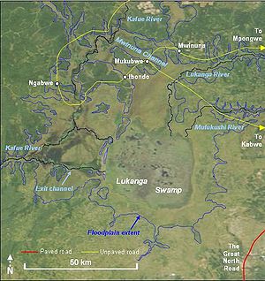
. Its permanently swampy area consists of a roughly circular area with a diameter of 40 to 50 km covering 1850 km², plus roughly 250 km² in the mouths of and along rivers discharging into it such as the Lukanga River from the north-east, plus another 500 km² either side of the Kafue River to the west and north-west, making 2600 km² in total. It contains many lagoons such as Lake Chiposhye and Lake Suye but few large channels, and its average depth is only 1.5 m.
River connections and floodplains
The permanent swamp is surrounded by a seasonally-inundated floodplainFloodplain
A floodplain, or flood plain, is a flat or nearly flat land adjacent a stream or river that stretches from the banks of its channel to the base of the enclosing valley walls and experiences flooding during periods of high discharge...
, varying from about 5 to 25 km wide in the south and east, up to 40 km in the north, and reaching the Kafue River and its swamps 25 km to the west and north-west. When the Kafue floods it overflows north-west through the normally dry Mwinuna channel and into the lower Lukanga River, while another channel drains out of the swamp back into the Kafue in the south-west. The Kafue meanders through its own swamps which are up to 10 km wide and extend for 90 km along the river. Numerous short rivers and streams flow into the swamp from the south, east and north, of which the Lukanga is the largest. In the rainy season the floodplains are inundated increasing the area of the wetland to 6000 km², reaching a maximum of 8000 km² at the peak flooding of a good rainy season.
Human population & fishing
There are several inhabited islands of higher ground which stay dry through the rainy season, mainly in an arc along the western edge of the permanent swamp, such as Chilwa Island and Chiposha Island. In addition the swamp contains floating islands of papyrus which support temporary fishing camps. No seasonal roads or bridges reach into the permanently swampy areas, and only one road crosses any part of the floodplain to any extent, a dry-season road from KabweKabwe
Kabwe is the capital of the Zambian Central Province with a population estimated at 210,000. Formerly named Broken Hill, it was founded when the Broken Hill lead and zinc deposits were discovered in 1902. Kabwe also has a claim to being the birthplace of Zambian politics...
(with a feeder from Mpongwe
Mpongwe
The Mpongwe are an ethnic group in Gabon, notable as the earliest known dwellers around the Estuary, where Libreville is now located.The Mpongwe language identifies them as a subgroup of the Myènè people of the Bantus, who are believed to have been in the area for some 2,000 years, although the...
) going through Mukobwe and Ibondo to a ferry across the Kafue and on to Ngabwe. Two other dirt tracks come from Mumbwa
Mumbwa
Mumbwa is a town in the Central Province of Zambia, lying on the Great West Road. Its district covers the western part of the Central Province bordering Kaoma and Western Province to the west, Namwala and Southern Province to the south, Lusaka and Lusaka Province to the east, Kasempa and...
in the south to the river near Mswebe and to the floodplain at Mwanamulambo. Despite its central location in the country, the Lukanga Swamp remains relatively inaccessible and even today government authorities in Kabwe and Lusaka
Lusaka
Lusaka is the capital and largest city of Zambia. It is located in the southern part of the central plateau, at an elevation of about 1,300 metres . It has a population of about 1.7 million . It is a commercial centre as well as the centre of government, and the four main highways of Zambia head...
have relatively little knowledge of or effect on the area.
The inhabitants of villages mainly around the north-east, east and southern floodplain practise traditional methods of fishing in the swamps and farm the edge of the floodplain. There is no commercial fishing of any size, but FAO reported a 1980 estimate of 2600 t for the fish catch, sold in the markets of Lusaka, Kabwe, and the Copperbelt.. A more recent report puts the figure at 1,200 t and notes declining catches due to over-fishing.
There are some smaller commercial farms especially near the Great North Road
Great North Road (Zambia)
The Great North Road is a major route in Zambia, running north from Lusaka through Kabwe, Kapiri Mposhi Serenje, Mpika, Kasama, Mbala and Mpulungu. 82km North of Mpika is a signposted left turn onto a well maintained gravel road leading to Shiwa Ng'andu and Kapishya Hot Springs...
which passes within 10 km of the floodplain at the south-eastern edge. Several large commercial farms and plantations, some with dry-season irrigation, have been established on the north side of the floodplain.
Wildlife & conservation issues
The floodplain is classed as the Zambezian flooded grasslands ecoregion, and the surrounding woodland savanna is the Central Zambezian Miombo woodlands ecoregion, except on the south-east side which is Zambezian and Mopane woodlands ecoregion. Flooded grasslands are considered to be productive and diverse owing to the nutrients brought by the flood and the fact they provide both grazing and aquatic habitats.The miombo woodland west of the Kafue River is a game management area stretching as far as Kafue National Park
Kafue National Park
Kafue National Park is the largest national park in Zambia, covering an area of about 22,400 km² . It is the second largest park in Africa and is home to over 55 different species of animals....
. Lukanga Swamp therefore could be considered a potential extension of that rich wildlife haven.
Lukanga Swamp is home to 316 reported bird species. It supports populations of hippopotamus
Hippopotamus
The hippopotamus , or hippo, from the ancient Greek for "river horse" , is a large, mostly herbivorous mammal in sub-Saharan Africa, and one of only two extant species in the family Hippopotamidae After the elephant and rhinoceros, the hippopotamus is the third largest land mammal and the heaviest...
, and crocodile
Crocodile
A crocodile is any species belonging to the family Crocodylidae . The term can also be used more loosely to include all extant members of the order Crocodilia: i.e...
, and is considered an important site for conservation of lechwe
Lechwe
The Lechwe, or Southern Lechwe, is an antelope found in Botswana, Zambia, south-eastern Democratic Republic of the Congo, north-eastern Namibia, and eastern Angola, especially in the Okavango Delta, Kafue Flats and Bangweulu Swamps....
, oribi
Oribi
Oribi are graceful slender-legged, long-necked small antelope found in grassland almost throughout Sub-Saharan Africa.-Description:...
, marsh mongoose
Marsh Mongoose
The Marsh Mongoose, or Water Mongoose, is a medium-sized mammal but a large mongoose. Weight can range from , with an average range of . From the head to the base of the tail, these animals range from , with the tail adding . It is a member of the mongoose family and the only member of its genus...
, sitatunga
Sitatunga
The situtunga or marshbuck is a swamp-dwelling antelope found throughout Central Africa, centering on the Democratic Republic of the Congo, Cameroon and parts of Southern Sudan as well as in Ghana, Botswana, Zambia, Gabon, Tanzania, Uganda and Kenya.-Description:Situtunga stand about one and a...
, bushbuck
Bushbuck
The bushbuck is the most widespread antelope in Sub-Saharan Africa, and is found in rain forests, montane forests, forest-savanna mosaics and bush savannaforest and woodland. Recently, genetic studies have shown that the bushbuck, is in fact a complex of two geographically and phenotypically...
, and python. The western side is visited by elephant
Elephant
Elephants are large land mammals in two extant genera of the family Elephantidae: Elephas and Loxodonta, with the third genus Mammuthus extinct...
, buffalo, eland
Common Eland
The common eland , also known as the southern eland or eland antelope, is a savannah and plains antelope found in East and Southern Africa. It is the largest antelope in the African continent...
and roan antelope
Roan Antelope
The Roan Antelope is a savanna antelope found in West, Central, East Africa and Southern Africa.Roan Antelope stand about a metre and half at the shoulder and weigh around 250 kilograms. Named for the "roan' colour , they have a lighter underbelly, white eyebrows and cheeks and a black face,...
. In 2000 the Department of National Parks and Wildlife Service (NPWS) was reported to be under-resourced in the area and the swamps "are virtually unprotected, and poaching is excessive".
Deforestation
Deforestation
Deforestation is the removal of a forest or stand of trees where the land is thereafter converted to a nonforest use. Examples of deforestation include conversion of forestland to farms, ranches, or urban use....
for charcoal
Charcoal
Charcoal is the dark grey residue consisting of carbon, and any remaining ash, obtained by removing water and other volatile constituents from animal and vegetation substances. Charcoal is usually produced by slow pyrolysis, the heating of wood or other substances in the absence of oxygen...
production and for 'slash and burn'
Slash and burn
Slash-and-burn is an agricultural technique which involves cutting and burning of forests or woodlands to create fields. It is subsistence agriculture that typically uses little technology or other tools. It is typically part of shifting cultivation agriculture, and of transhumance livestock...
and other types of farming is also reported as a major threat to the Lukanga Swamp ecosystem
Ecosystem
An ecosystem is a biological environment consisting of all the organisms living in a particular area, as well as all the nonliving , physical components of the environment with which the organisms interact, such as air, soil, water and sunlight....
mainly
because it results in erosion
Erosion
Erosion is when materials are removed from the surface and changed into something else. It only works by hydraulic actions and transport of solids in the natural environment, and leads to the deposition of these materials elsewhere...
of the land, turbidity
Turbidity
Turbidity is the cloudiness or haziness of a fluid caused by individual particles that are generally invisible to the naked eye, similar to smoke in air. The measurement of turbidity is a key test of water quality....
of the water and siltation
Siltation
Siltation is the pollution of water by fine particulate terrestrial clastic material, with a particle size dominated by silt or clay. It refers both to the increased concentration of suspended sediments, and to the increased accumulation of fine sediments on bottoms where they are undesirable...
. In nearly all areas north-east of the swamp forests have been cleared especially for charcoal production, and land clearing for farming has been extensive on the north-east, east and southern sides of the swamp. Only the western side remains relatively untouched. The development of a tourism industry in the area, which (as has been seen for the national parks) results in greater wildlife conservation efforts, depends on providing access to this part from Mumbwa or Kabwe.
Origin of Lukanga Swamp
The nearly circular shape of the main permanent swamp has led to speculation that Lukanga Swamp may be an impact craterImpact crater
In the broadest sense, the term impact crater can be applied to any depression, natural or manmade, resulting from the high velocity impact of a projectile with a larger body...
(astrobleme) formed by the impact of a meteorite
Meteorite
A meteorite is a natural object originating in outer space that survives impact with the Earth's surface. Meteorites can be big or small. Most meteorites derive from small astronomical objects called meteoroids, but they are also sometimes produced by impacts of asteroids...
.
However research on the ground in 2002 found no evidence of impact shock
Shock (mechanics)
A mechanical or physical shock is a sudden acceleration or deceleration caused, for example, by impact, drop, kick, earthquake, or explosion. Shock is a transient physical excitation....
in rocks of the area, concluding that the Lukanga Swamp is not an astrobleme. In the absence of other research data the origin of the swamp is unknown.