

Luapula Province
Encyclopedia
Zambia
Zambia , officially the Republic of Zambia, is a landlocked country in Southern Africa. The neighbouring countries are the Democratic Republic of the Congo to the north, Tanzania to the north-east, Malawi to the east, Mozambique, Zimbabwe, Botswana and Namibia to the south, and Angola to the west....
's nine provinces
Provinces of Zambia
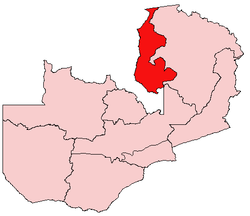
Zambia is divided into 10 provinces.-References:...
, and is located in the north of the country. The provincial capital is Mansa
Mansa, Zambia
Mansa is the capital of the Luapula Province of Zambia, and headquarters of Mansa District. It takes its name from the local Chief Mansa and the small Mansa River which flows west to the Luapula River...
. Luapula Province was named after the Luapula River
Luapula River
The Luapula River is a section of Africa's second-longest river, the Congo. It is a transnational river forming for nearly all its length part of the border between Zambia and the DR Congo...
.
It extends along the northern and eastern banks of the river from Lake Bangweulu
Lake Bangweulu
Bangweulu — 'where the water sky meets the sky' — is one of the world's great wetland systems, comprising Lake Bangweulu, the Bangweulu Swamps and the Bangweulu Flats or floodplain...
to Lake Mweru
Lake Mweru
Lake Mweru is a freshwater lake on the longest arm of Africa's second-longest river, the Congo. Located on the border between Zambia and Democratic Republic of the Congo, it makes up 110 km of the total length of the Congo, lying between its Luapula River and Luvua River segments.Mweru...
, including waters and islands of those lakes, and is inhabited by Bemba
Bemba language
The Bemba language, ChiBemba , is a major Bantu language spoken primarily in north-eastern Zambia by the Bemba people and as a lingua franca by about 18 related ethnic groups, including the Bisa people of Mpika and Lake Bangweulu, and to a lesser extent in Katanga in the Democratic Republic of the...
-speaking peoples (including the Lunda
Eastern Lunda
The Lunda people of the Luapula River valley in Zambia and DR Congo are called by others the Eastern Lunda to distinguish them from the 'western' Lunda people who remained in the heartland of the former Lunda Kingdom, but they themselves would use Kazembe-Lunda or Luunda with an elongated 'u' to...
, Kabende, Aushi, Chishinga and Bemba
Bemba people
The Bemba belong to a large group of peoples mainly in the Northern, Luapula and Copperbelt Provinces of Zambia who trace their origins to the Luba and Lunda states of the upper Congo basin, in what became Katanga Province in southern Congo-Kinshasa...
). The major economic activity is fishing. The chief artery of the province is the Samfya
Samfya
Samfya is a town located in the Zambian province of Luapula. It is the center of Samfya District. The town is located on the south-western shore of Lake Bangweulu, on the longest stretch of well-defined shore of that lake...
-Mansa
Mansa
Mansa is a Mandinka word meaning "king of kings". It is particularly associated with the Keita Dynasty of the Mali Empire, which dominated West Africa from the thirteenth to the fifthteenth century...
-Mwansabombwe
Kazembe (Mwansabombwe)
Kazembe is a name used for Mwata Kazembe's town in the Luapula Province of Zambia, especially on maps and in the Zambian postal service . However, the correct name for the town is Mwansabombwe and this is the one used by its or Luba or Chibemba-speaking inhabitants...
-Nchelenge
Nchelenge
Nchelenge is a town in the Luapula Province of northern Zambia, lying on the south eastern shore of Lake Mweru. It is contiguous with Kashikishi, and they are sometimes referred to as Nchelenge-Kashikishi...
highway known informally as the Zambia Way.
In the 19th century the valley was dominated by the Lunda kingdom of Mwata Kazembe.
The province is bordered along the Luapula River, through Lake Mweru and to its north by DR Congo which at times has led to disputes and conflict. The Congo Pedicle
Congo Pedicle
The Congo Pedicle refers to the southeast salient of the Katanga Province of the Democratic Republic of Congo which sticks into neighbouring Zambia almost dividing it into two lobes, like the wings of a butterfly. In area the pedicle is similar in size to Wales or New Jersey...
comes between the province and the industrial and commercial heartland of the Copperbelt which has caused problems partly resolved by construction of the Luapula Bridge and the Samfya
Samfya
Samfya is a town located in the Zambian province of Luapula. It is the center of Samfya District. The town is located on the south-western shore of Lake Bangweulu, on the longest stretch of well-defined shore of that lake...
-Serenje
Serenje
Serenje is a district in Zambia. There is also the town of Serenje lying just off the Great North Road and TAZARA Railway. The British, during the time that Northern Rhodesia was a British protectorate, designated Serenje as a BOMA . To this day, the locals refer to Serenje Town as the BOMA....
road, and being further alleviated by the construction of the Chembe Bridge.
National Parks and wildlife areas
- For further details see Luapula Province in Wildlife of Zambia
- Lusenga Plain National Park is inaccessible, needs management and has been depleted by poaching.
- Lake MweruLake MweruLake Mweru is a freshwater lake on the longest arm of Africa's second-longest river, the Congo. Located on the border between Zambia and Democratic Republic of the Congo, it makes up 110 km of the total length of the Congo, lying between its Luapula River and Luvua River segments.Mweru...
-Luapula RiverLuapula RiverThe Luapula River is a section of Africa's second-longest river, the Congo. It is a transnational river forming for nearly all its length part of the border between Zambia and the DR Congo...
system: bird life, aquatic animals, fish (rather depleted). - Lake BangweuluLake BangweuluBangweulu — 'where the water sky meets the sky' — is one of the world's great wetland systems, comprising Lake Bangweulu, the Bangweulu Swamps and the Bangweulu Flats or floodplain...
and its wetlands: bird life, aquatic animals, fish.
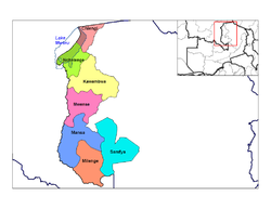
Districts
District
Districts are a type of administrative division, in some countries managed by a local government. They vary greatly in size, spanning entire regions or counties, several municipalities, or subdivisions of municipalities.-Austria:...
s:
|
Nchelenge Nchelenge is a town in the Luapula Province of northern Zambia, lying on the south eastern shore of Lake Mweru. It is contiguous with Kashikishi, and they are sometimes referred to as Nchelenge-Kashikishi... Samfya Samfya is a town located in the Zambian province of Luapula. It is the center of Samfya District. The town is located on the south-western shore of Lake Bangweulu, on the longest stretch of well-defined shore of that lake... |
See also
- Lake MweruLake MweruLake Mweru is a freshwater lake on the longest arm of Africa's second-longest river, the Congo. Located on the border between Zambia and Democratic Republic of the Congo, it makes up 110 km of the total length of the Congo, lying between its Luapula River and Luvua River segments.Mweru...
- Lake BangweuluLake BangweuluBangweulu — 'where the water sky meets the sky' — is one of the world's great wetland systems, comprising Lake Bangweulu, the Bangweulu Swamps and the Bangweulu Flats or floodplain...
- Congo PedicleCongo PedicleThe Congo Pedicle refers to the southeast salient of the Katanga Province of the Democratic Republic of Congo which sticks into neighbouring Zambia almost dividing it into two lobes, like the wings of a butterfly. In area the pedicle is similar in size to Wales or New Jersey...
- Mwata Kazembe