

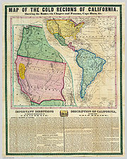
Death Valley '49ers
Encyclopedia
The Death Valley '49ers were a group of pioneer
s from the Eastern United States
that endured a long difficult journey during the late 1840s California Gold Rush
to prospect
in the Sutter's Fort
area of the Central Valley and Sierra Nevada in California
. Their route from Utah went through the Great Basin Desert
in Nevada
, and Death Valley
and the Mojave Desert
in Southern California
, in attempting to reach the Gold Country
.
and his crew found gold at Sutter's Mill in Coloma, California
. This discovery would lure tens of thousands of people from the United States and foreign nations. People packed their belongings and began to travel by covered wagon
to what they hoped would be new and better life. Since the first great influx of these pioneers began in 1849, they are generally referred to as 49ers.
 One of the supply points along the trail was Salt Lake City, where pioneers prepared for the long journey across the Great Basin
desert before climbing over the High Sierra Mountains to the gold fields of California. It was important to leave Salt Lake City and cross the desert before snow began to fall on the Sierra Mountains, making them impassable.
Only a couple of years before, a group of pioneers called the Donner Party
left late out of Salt Lake City and was trapped by a storm, an event that became one of the greatest human disasters of that day and age. The stories of the Donner Party were still fresh on everyone's mind when a group of wagons arrived at Salt Lake City in October 1849. This was much too late to try to cross the mountains safely and the appeared the group would have to wait out the winter in Salt Lake City. Hearing about the Old Spanish Trail
, a route that went around the south end of the Sierras and was safe to travel in the winter but which no pioneer wagon trains had ever tried to follow it, they found a guide who knew the route and would agree to lead them. These individuals would become part of a story of human suffering in a place which they named Death Valley
.
The first two weeks of travel on the Old Spanish Trail were easy, but the going was slower than most of the travelers wanted. The leader of the group, Captain Jefferson Hunt
, would only go as fast as the slowest wagon in the group. Just as the people were about to voice their dissent, a young man rode into camp and showed some of the people a map made by John Fremont on one of his exploratory trips through the area.
. Everyone agreed that this would cut off 500 miles from their journey so most of the 120 wagons decided to follow this map while the other wagons continued along the Old Spanish Trail with Captain Hunt. The point where these wagons left the Old Spanish Trail is near the present day town of Enterprise, Utah
where a monument (Jefferson Hunt Monument) has been constructed to commemorate this historic event. Almost as soon as these people began their journey, they found themselves confronted with the precipitous obstacle of Beaver Dam Wash
, a gaping canyon on the present day Utah-Nevada state line (Beaver Dam State Park, Nevada).
Most of the people became discouraged and turned back to join Jefferson Hunt, but about 20 wagons decided to continue on. It was a tedious chore getting the wagons across the canyon and took several days. In the meantime, the young man who had the map of the shortcut got impatient and, under the cloak of darkness, left the group. Despite the fact that the group didn't have a map, they decided to continue on thinking that all they had to do was go west and they would eventually find the pass.
After crossing Beaver Dam Wash the group passed through the area of present day Panaca, Nevada
and crossed over "Bennetts Pass" to Del Mar Valley. Here they started having difficulty finding water but eventually found their way to Crystal Springs
in the Pahranagat Valley
. They continued over Hancock Summit into Tikaboo Valley and then on to Groom Lake
in central Nevada. They had now been slowly making their way across the desert for almost a month since they had left the Old Spanish Trail . At Groom Lake they got into a dispute on which way to go. One group wanted to follow a well traveled Indian trail to the south in hopes of finding a good water source. The other group wanted to stay with the original plan of traveling west.
The two groups eventually split and went their separate ways, but they both were to have two things in common. They were both saved from dying of thirst by a snow storm and they both ended up meeting again in a place called Ash Meadows
near Amargosa Valley
in the Amargosa Desert
located east of Death Valley. From here they continued on, following the Amargosa River
bed through present day Death Valley Junction, California
, and then along the same route followed by current California State Route 190
past the Funeral Mountains
.
, located about a mile from Furnace Creek Wash
in Death Valley
itself.
The lost pioneers had now been traveling across the desert for about two months since leaving the Old Spanish Trail. Their oxen were weak from lack of forage and their wagons were battered and in poor shape. They too were weary and discouraged but their worst problem was not the valley that lay before them. It was the towering Panamint Range
mountains to the west that stood like an impenetrable wall as far as could be seen in both directions.
They decided to head toward what appeared to be a pass to the north near present day Stovepipe Wells, California
, but after discovering this was also impassable, decided they were going to have to leave their wagons and belongings behind and walk to civilization. They slaughtered several oxen and used the wood of their wagons to cook the meat and make jerky. The place where they did this is today referred to as "Burned Wagons Camp", present day Burnt Wagons, California
, and is located near the sand dunes of Death Valley. From here, they began climbing toward Towne Pass and then turned south over Emigrant Pass to Wildrose Canyon in the Panamint Range.
After crossing the mountains and dropping down into Panamint Valley
, they turned south and climbed a small pass into Searles Valley
, with Searles Lake
, before making their way into Indian Wells Valley
near the present day city of Ridgecrest, California
. It was here that they finally got their first look at the Sierra Nevada (U.S.) Mountains. They turned south, probably following a trail and traveled across Fremont Valley
, close to the same route followed by current California State Route 14
. Ironically, they walked right by Walker Pass
, present day California State Route 178
to Lake Isabella
, the mountain pass
they had set out to look for almost three months earlier.
Passing by Walker Pass, they entered into what was to become the worst part of their journey, across the Mojave Desert
and its Antelope Valley
. This is a region with very few water sources to be found. The only things that saved them from dying of thirst were a few puddles of water and ice from a recent storm. Eventually they found their way over a pass in the Sierra Pelona Mountains
near Palmdale, California
and, following the Santa Clara River
, were finally discovered and rescued by Mexican Californios cowboys from Rancho Ex-Mission San Fernando
, located near present day Santa Clarita Valley
.
American pioneer
American pioneers are any of the people in American history who migrated west to join in settling and developing new areas. The term especially refers to those who were going to settle any territory which had previously not been settled or developed by European or American society, although the...
s from the Eastern United States
Eastern United States
The Eastern United States, the American East, or simply the East is traditionally defined as the states east of the Mississippi River. The first two tiers of states west of the Mississippi have traditionally been considered part of the West, but can be included in the East today; usually in...
that endured a long difficult journey during the late 1840s California Gold Rush
California Gold Rush
The California Gold Rush began on January 24, 1848, when gold was found by James W. Marshall at Sutter's Mill in Coloma, California. The first to hear confirmed information of the gold rush were the people in Oregon, the Sandwich Islands , and Latin America, who were the first to start flocking to...
to prospect
Prospecting
Prospecting is the physical search for minerals, fossils, precious metals or mineral specimens, and is also known as fossicking.Prospecting is a small-scale form of mineral exploration which is an organised, large scale effort undertaken by mineral resource companies to find commercially viable ore...
in the Sutter's Fort
Sutter's Fort
Sutter's Fort State Historic Park is a state-protected park in Sacramento, California which includes Sutter's Fort and the California State Indian Museum. Begun in 1839 and originally called "New Helvetia" by its builder, John Sutter, the fort was a 19th century agricultural and trade colony in...
area of the Central Valley and Sierra Nevada in California
California
California is a state located on the West Coast of the United States. It is by far the most populous U.S. state, and the third-largest by land area...
. Their route from Utah went through the Great Basin Desert
Great Basin Desert
The Great Basin Desert is an area of nearctic high deserts across parts of Nevada, California, and Utah that extends into the Colorado River watershed , but which is mostly a portion of the central Nevada desert basins of the Great Basin.It along with the Escalante Desert, Mohave Desert, the...
in Nevada
Nevada
Nevada is a state in the western, mountain west, and southwestern regions of the United States. With an area of and a population of about 2.7 million, it is the 7th-largest and 35th-most populous state. Over two-thirds of Nevada's people live in the Las Vegas metropolitan area, which contains its...
, and Death Valley
Death Valley
Death Valley is a desert valley located in Eastern California. Situated within the Mojave Desert, it features the lowest, driest, and hottest locations in North America. Badwater, a basin located in Death Valley, is the specific location of the lowest elevation in North America at 282 feet below...
and the Mojave Desert
Mojave Desert
The Mojave Desert occupies a significant portion of southeastern California and smaller parts of central California, southern Nevada, southwestern Utah and northwestern Arizona, in the United States...
in Southern California
Southern California
Southern California is a megaregion, or megapolitan area, in the southern area of the U.S. state of California. Large urban areas include Greater Los Angeles and Greater San Diego. The urban area stretches along the coast from Ventura through the Southland and Inland Empire to San Diego...
, in attempting to reach the Gold Country
Gold Country
Gold Country is a region in the central and northeastern part of California, United States. It is famed for the mineral deposits and gold mines that attracted waves of immigrants, known as the 49ers, during the 1849 California Gold Rush.-Geography:State Route 49 was built through the Gold Country,...
.
The Gold Rush
On January 24, 1848 James W. MarshallJames W. Marshall
James Wilson Marshall was an American carpenter and sawmill operator, whose discovery of gold in the American River in California on January 24, 1848 set the stage for the California Gold Rush. The mill property was owned by Johan Sutter who employed Marshall to build his mill...
and his crew found gold at Sutter's Mill in Coloma, California
Coloma, California
Coloma is a census-designated place in El Dorado County, California, USA. It is approximately northeast of Sacramento, California. Coloma is most noted for being the site where James W. Marshall first discovered gold in California, at Sutter's Mill on January 24, 1848, leading to the California...
. This discovery would lure tens of thousands of people from the United States and foreign nations. People packed their belongings and began to travel by covered wagon
Covered wagon
The covered wagon, also known as a Prairie schooner, is an icon of the American Old West.Although covered wagons were commonly used for shorter moves within the United States, in the mid-nineteenth century thousands of Americans took them across the Great Plains to Oregon and California...
to what they hoped would be new and better life. Since the first great influx of these pioneers began in 1849, they are generally referred to as 49ers.
The Start
Great Basin
The Great Basin is the largest area of contiguous endorheic watersheds in North America and is noted for its arid conditions and Basin and Range topography that varies from the North American low point at Badwater Basin to the highest point of the contiguous United States, less than away at the...
desert before climbing over the High Sierra Mountains to the gold fields of California. It was important to leave Salt Lake City and cross the desert before snow began to fall on the Sierra Mountains, making them impassable.
Only a couple of years before, a group of pioneers called the Donner Party
Donner Party
The Donner Party was a group of American pioneers who set out for California in a wagon train. Delayed by a series of mishaps, they spent the winter of 1846–47 snowbound in the Sierra Nevada...
left late out of Salt Lake City and was trapped by a storm, an event that became one of the greatest human disasters of that day and age. The stories of the Donner Party were still fresh on everyone's mind when a group of wagons arrived at Salt Lake City in October 1849. This was much too late to try to cross the mountains safely and the appeared the group would have to wait out the winter in Salt Lake City. Hearing about the Old Spanish Trail
Old Spanish Trail (trade route)
The Old Spanish Trail is a historical trade route which connected the northern New Mexico settlements near or in Santa Fe, New Mexico with that of Los Angeles, California and southern California. Approximately long, it ran through areas of high mountains, arid deserts, and deep canyons. It is...
, a route that went around the south end of the Sierras and was safe to travel in the winter but which no pioneer wagon trains had ever tried to follow it, they found a guide who knew the route and would agree to lead them. These individuals would become part of a story of human suffering in a place which they named Death Valley
Death Valley
Death Valley is a desert valley located in Eastern California. Situated within the Mojave Desert, it features the lowest, driest, and hottest locations in North America. Badwater, a basin located in Death Valley, is the specific location of the lowest elevation in North America at 282 feet below...
.
The first two weeks of travel on the Old Spanish Trail were easy, but the going was slower than most of the travelers wanted. The leader of the group, Captain Jefferson Hunt
Jefferson Hunt
Jefferson Hunt was a U.S. western pioneer, soldier, and politician. He was a captain in the Mormon Battalion, brigadier general in the California State Militia, a California State Assemblyman, and a representative to the Utah Territorial Legislature.-Early years:Hunt was born to John Hunt and...
, would only go as fast as the slowest wagon in the group. Just as the people were about to voice their dissent, a young man rode into camp and showed some of the people a map made by John Fremont on one of his exploratory trips through the area.
The parties Split-Up
The map showed a shortcut across the desert to a place called Walker PassWalker Pass
Walker Pass is a mountain pass by Lake Isabella in the southern Sierra Nevada mountains. It is located in northeastern Kern County, approximately 53 mi ENE of Bakersfield and 10 mi WNW of Ridgecrest...
. Everyone agreed that this would cut off 500 miles from their journey so most of the 120 wagons decided to follow this map while the other wagons continued along the Old Spanish Trail with Captain Hunt. The point where these wagons left the Old Spanish Trail is near the present day town of Enterprise, Utah
Enterprise, Utah
Enterprise is a city in Washington County, Utah, United States. The population was 1,711 at the 2010 census. Enterprise is home to two schools, Enterprise Elementary School and Enterprise High School .-Geography:...
where a monument (Jefferson Hunt Monument) has been constructed to commemorate this historic event. Almost as soon as these people began their journey, they found themselves confronted with the precipitous obstacle of Beaver Dam Wash
Beaver Dam Wash
The Beaver Dam Wash is a seasonal stream near the southwestern Utah-Nevada border. At its southern end in northern Arizona, near the point where it empties into the Virgin River, the stream flows throughout the year....
, a gaping canyon on the present day Utah-Nevada state line (Beaver Dam State Park, Nevada).
Most of the people became discouraged and turned back to join Jefferson Hunt, but about 20 wagons decided to continue on. It was a tedious chore getting the wagons across the canyon and took several days. In the meantime, the young man who had the map of the shortcut got impatient and, under the cloak of darkness, left the group. Despite the fact that the group didn't have a map, they decided to continue on thinking that all they had to do was go west and they would eventually find the pass.
After crossing Beaver Dam Wash the group passed through the area of present day Panaca, Nevada
Panaca, Nevada
Panaca is a town in eastern Lincoln County, Nevada, on State Route 319, about 1 mile east of U.S. Route 93, near the border with Utah. Its elevation is 4,729 feet .-History:...
and crossed over "Bennetts Pass" to Del Mar Valley. Here they started having difficulty finding water but eventually found their way to Crystal Springs
Crystal Springs, Nevada
Crystal Springs is a ghost town in the Pahranagat Valley region of Lincoln County, Nevada. The ghost town is located at the junction of SR 318 and SR 375, also known as the Extraterrestrial Highway. It is a popular destination for passersby who want to visit the towns of Hiko and Rachel...
in the Pahranagat Valley
Pahranagat Valley
The Pahranagat Valley is a Tonopah Basin landform in Lincoln County, Nevada.The more fertile part of Pahranagat Valley is a narrow ribbon of green like an oasis in the vast Nevada desert...
. They continued over Hancock Summit into Tikaboo Valley and then on to Groom Lake
Groom Lake
Groom Lake is a salt flat in Nevada used for runways of the Nellis Bombing Range Test Site airport on the north of the Area 51 USAF military installation. The lake at elevation is ~ from north to south and from east to west at its widest point...
in central Nevada. They had now been slowly making their way across the desert for almost a month since they had left the Old Spanish Trail . At Groom Lake they got into a dispute on which way to go. One group wanted to follow a well traveled Indian trail to the south in hopes of finding a good water source. The other group wanted to stay with the original plan of traveling west.
The two groups eventually split and went their separate ways, but they both were to have two things in common. They were both saved from dying of thirst by a snow storm and they both ended up meeting again in a place called Ash Meadows
Ash Meadows National Wildlife Refuge
The Ash Meadows National Wildlife Refuge is a protected wildlife refuge, administered by the U.S. Fish and Wildlife Service, located west-northwest of Las Vegas, Nevada, in southern Nye County...
near Amargosa Valley
Amargosa Valley
The Amargosa Valley is a Nevada landform east of the Amargosa Range that is the eponym for the town of Amargosa Valley, Nevada. The Tonopah and Tidewater Railroad ran through the valley from 1906 to 1940.-Solar thermal plant:...
in the Amargosa Desert
Amargosa Desert
The Amargosa Desert is located in Nye County in western Nevada, United States, along the California–Nevada border. It is largely coincident with the geographic Amargosa Valley....
located east of Death Valley. From here they continued on, following the Amargosa River
Amargosa River
The Amargosa River is an intermittent waterway, long, in southern Nevada and eastern California in the United States. It drains a high desert region, the Amargosa Valley in the Amargosa Desert northwest of Las Vegas, into the Mojave Desert, and finally into Death Valley where it disappears into...
bed through present day Death Valley Junction, California
Death Valley Junction, California
Death Valley Junction is a tiny Mojave Desert community in unincorporated Inyo County, California, at the intersection of SR 190 and SR 127, just east of Death Valley National Park. The zip code is 92328, the elevation is , and the population fewer than 20. The city limits sign reports a...
, and then along the same route followed by current California State Route 190
California State Route 190
State Route 190 is a state highway in the U.S. state of California that is split into two parts by the Sierra Nevada. The western portion of begins at Tipton at a junction with State Route 99 and heads east towards Porterville before ending at Quaking Aspen in the Sequoia National Forest...
past the Funeral Mountains
Funeral Mountains
The Funeral Mountains are a short, arid mountain range in the United States along the California-Nevada border approximately 100 mi west of Las Vegas. The mountains are considered a subrange of the Amargosa Range that form the eastern wall of Death Valley.The Amargosa Desert lies along the...
.
Lost pioneers in Death Valley
On Christmas Eve of 1849, the group arrived at Travertine Springs in the western facing canyon of the Amargosa RangeAmargosa Range
The Amargosa Range is a mountain range in Inyo County, California and Nye County, Nevada. The range runs along most of the eastern side of California's Death Valley, separating it from Nevada's Amargosa Desert...
, located about a mile from Furnace Creek Wash
Furnace Creek, California
Furnace Creek is a census-designated place in Inyo County, California, United States. The population was 24 at the 2010 census, down from 31 at the 2000 census. The elevation of the village is below sea level....
in Death Valley
Death Valley
Death Valley is a desert valley located in Eastern California. Situated within the Mojave Desert, it features the lowest, driest, and hottest locations in North America. Badwater, a basin located in Death Valley, is the specific location of the lowest elevation in North America at 282 feet below...
itself.
The lost pioneers had now been traveling across the desert for about two months since leaving the Old Spanish Trail. Their oxen were weak from lack of forage and their wagons were battered and in poor shape. They too were weary and discouraged but their worst problem was not the valley that lay before them. It was the towering Panamint Range
Panamint Range
The Panamint Range is a short rugged fault-block mountain range on the northern edge of the Mojave Desert, in Death Valley National Park, Inyo County, California, United States.-Geography:...
mountains to the west that stood like an impenetrable wall as far as could be seen in both directions.
They decided to head toward what appeared to be a pass to the north near present day Stovepipe Wells, California
Stovepipe Wells, California
Stovepipe Wells is a small way-station in the northern part of Death Valley, in unincorporated Inyo County, California.-Geography and names:Stovepipe Wells is located at and is US Geological Survey feature ID 235564. It is entirely inside Death Valley National Park and along State Route 190 at...
, but after discovering this was also impassable, decided they were going to have to leave their wagons and belongings behind and walk to civilization. They slaughtered several oxen and used the wood of their wagons to cook the meat and make jerky. The place where they did this is today referred to as "Burned Wagons Camp", present day Burnt Wagons, California
Burnt Wagons, California
Burnt Wagons is a former settlement in Inyo County, California. It was located in Death Valley northwest of Death Valley Junction. The name recalls the emigrants of 1849 who abandoned and burnt their wagons at the site....
, and is located near the sand dunes of Death Valley. From here, they began climbing toward Towne Pass and then turned south over Emigrant Pass to Wildrose Canyon in the Panamint Range.
After crossing the mountains and dropping down into Panamint Valley
Panamint Valley
The Panamint Valley is a long basin located east of the Argus Range and Slate Range, and west of the Panamint Range in the northeastern reach of the Mojave Desert, in eastern California, United States.-Geography:...
, they turned south and climbed a small pass into Searles Valley
Searles Valley
Searles Valley is a valley in the northern Mojave Desert of California, with the northern half in Inyo County and the southern half in San Bernardino County, California, United States....
, with Searles Lake
Searles Lake
Searles Lake is an endorheic dry lake in the Mojave Desert of San Bernardino County, California, with the mining community, Trona on its western shore. The evaporite basin is approximately long and at its widest point, yielding 1.7 million tons annually of industrial minerals within the basin to...
, before making their way into Indian Wells Valley
Indian Wells Valley
Indian Wells Valley is an arid north-south basin in east-central California. In the geologic sense, it is a southern extension of Owens Valley to the north, with the recent volcanics of the Coso Range being the separator...
near the present day city of Ridgecrest, California
Ridgecrest, California
Ridgecrest, formerly known as Crumville, was incorporated as a city in 1913. It is located in the Indian Wells Valley in northeastern Kern County, California, adjacent to the Naval Air Weapons Station China Lake . Ridgecrest is the only incorporated city along US 395 in Kern County...
. It was here that they finally got their first look at the Sierra Nevada (U.S.) Mountains. They turned south, probably following a trail and traveled across Fremont Valley
Fremont Valley
The Fremont Valley is a valley located in the western Mojave Desert of California.It stretches from the town of Mojave approximately 70 km northeast to the foothills of the Lava Mountains and Summit Range....
, close to the same route followed by current California State Route 14
California State Route 14
State Route 14 is a north–south state highway in the U.S. state of California, largely in the Mojave Desert. The southern portion of the highway is signed as the Antelope Valley Freeway. The route connects Interstate 5, or Golden State Freeway, near Santa Clarita and with U.S. Route 395 near...
. Ironically, they walked right by Walker Pass
Walker Pass
Walker Pass is a mountain pass by Lake Isabella in the southern Sierra Nevada mountains. It is located in northeastern Kern County, approximately 53 mi ENE of Bakersfield and 10 mi WNW of Ridgecrest...
, present day California State Route 178
California State Route 178
State Route 178 is a route that exists in two constructed segments. The gap in between segments is connected by various local roads and State Route 190 through Death Valley National Park....
to Lake Isabella
Lake Isabella
Lake Isabella is a reservoir in Kern County, California created by the earthen Isabella Dam. It was formed in 1953 when the U.S. Army Corps of Engineers dammed the Kern River at the junction of its two forks at Whiskey Flat. At 11,000 acres , it is one of the larger reservoirs in California...
, the mountain pass
Mountain pass
A mountain pass is a route through a mountain range or over a ridge. If following the lowest possible route, a pass is locally the highest point on that route...
they had set out to look for almost three months earlier.
Passing by Walker Pass, they entered into what was to become the worst part of their journey, across the Mojave Desert
Mojave Desert
The Mojave Desert occupies a significant portion of southeastern California and smaller parts of central California, southern Nevada, southwestern Utah and northwestern Arizona, in the United States...
and its Antelope Valley
Antelope Valley
The Antelope Valley in California, United States, is located in northern Los Angeles County and the southeastern portion of Kern County, California, and constitutes the western tip of the Mojave Desert...
. This is a region with very few water sources to be found. The only things that saved them from dying of thirst were a few puddles of water and ice from a recent storm. Eventually they found their way over a pass in the Sierra Pelona Mountains
Sierra Pelona Mountains
The Sierra Pelona Mountains , or the Sierra Pelona Ridge, is a mountain range in the Transverse Ranges of Southern California.. They are located within Los Angeles and Kern Counties.-Geography:...
near Palmdale, California
Palmdale, California
Palmdale is a city located in the center of northern Los Angeles County, California, United States.Palmdale was the first community within the Antelope Valley to incorporate as a city on August 24, 1962; 47 years later, voters approved creating a charter city in November, 2009. Palmdale is...
and, following the Santa Clara River
Santa Clara River (California)
The Santa Clara River is approximately long, located in southern California in the United States. It drains an area of the coastal mountains north of Los Angeles. The Santa Clara is one of the largest river systems along the coast of Southern California and one of only a few remaining river...
, were finally discovered and rescued by Mexican Californios cowboys from Rancho Ex-Mission San Fernando
Rancho Ex-Mission San Fernando
Rancho Ex-Mission San Fernando was a Mexican land grant in present day Los Angeles County, California granted in 1846 by Governor Pío Pico to Eulogio de Celis...
, located near present day Santa Clarita Valley
Santa Clarita Valley
The Santa Clarita Valley is the valley of the Santa Clara River in Southern California. It stretches through Los Angeles County and Ventura County. Its main population center is the city of Santa Clarita. The valley was part of the Rancho San Francisco Mexican land grant...
.
Legends
Legends, dramatic but untrue of these lost pioneers has often focused only on the Death Valley experiences, when other Nevada and California desert regions were also traversed.- All of the pioneers died which is why they call it Death Valley. Actually only one person died in Death Valley, an elderly man named Culverwell, who was half dead from the ordeals he met with in the two months these pioneers traveled across the Nevada desert before arriving at Death Valley.)
- It was very hot when the pioneers crossed Death Valley. Actually they arrived there in December, the winter. During this time of the year, it was extremely cold in the higher elevations of the Nevada Great Basin DesertGreat Basin DesertThe Great Basin Desert is an area of nearctic high deserts across parts of Nevada, California, and Utah that extends into the Colorado River watershed , but which is mostly a portion of the central Nevada desert basins of the Great Basin.It along with the Escalante Desert, Mohave Desert, the...
and the pioneers were saved from dying of thirst by a snow storm and by sheets of ice on puddles of water. The most comfortable temperatures they encountered on their journey were in Death Valley, which that make it a popular winter resort and tourist destination. - There was no water in Death Valley. Actually the pioneers found a large springSpring (hydrosphere)A spring—also known as a rising or resurgence—is a component of the hydrosphere. Specifically, it is any natural situation where water flows to the surface of the earth from underground...
, Travertine Springs, with an output of 2,000 gallons of water per minute. They also found water at Salt Creek and Wildrose Canyon as well as snow on Pinto Peak.
See also
- Death ValleyDeath ValleyDeath Valley is a desert valley located in Eastern California. Situated within the Mojave Desert, it features the lowest, driest, and hottest locations in North America. Badwater, a basin located in Death Valley, is the specific location of the lowest elevation in North America at 282 feet below...
- Death Valley National ParkDeath Valley National ParkDeath Valley National Park is a national park in the U.S. states of California and Nevada located east of the Sierra Nevada in the arid Great Basin of the United States. The park protects the northwest corner of the Mojave Desert and contains a diverse desert environment of salt-flats, sand dunes,...
- Geology of the Death Valley areaGeology of the Death Valley areaThe exposed geology of the Death Valley area presents a diverse and complex set of at least 23 formations of sedimentary units, two major gaps in the geologic record called unconformities, and at least one distinct set of related formations geologists call groups...
- Places of interest in the Death Valley areaPlaces of interest in the Death Valley areaPlaces of interest in the Death Valley area are mostly located within Death Valley National Park in eastern California.-Artist's Drive and Palette:...
- History of California to 1899History of California to 1899Human history in California begins with indigenous Americans first arriving in California some 13,000-15,000 years ago. Exploration and settlement by Europeans along the coasts and in the inland valleys began in the 16th century...