
Cyclone Jokwe
Encyclopedia
Cyclone Jokwe was the first tropical cyclone
to make landfall
in Mozambique
since Cyclone Favio struck in the previous year. The tenth named storm of the 2007-08 South-West Indian Ocean cyclone season
, Jokwe was first classified as a tropical depression on March 2 over the open Southwest Indian Ocean
. It tracked west-southwest, crossing northern Madagascar
as a tropical storm on March 5 before intensifying into a tropical cyclone
on March 6. Jokwe rapidly intensified to reach peak winds of 195 km/h (120 mph), before weakening slightly and striking Nampula Province
in northeastern Mozambique. It quickly weakened while paralleling the coastline, though the storm restrengthened as it turned southward in the Mozambique Channel. Late in its duration, it remained nearly stationary for several days, and steadily weakened due to wind shear
before dissipating on March 16.
The storm caused minor damage in northern Madagascar. In Mozambique, the cyclone affected 200,000 people, and left at least sixteen fatalities. Cyclone Jokwe destroyed over 9,000 houses and damaged over 3,000 more, with the heaviest damage in Angoche
and the Island of Mozambique
in Nampula Province. The storm also caused widespread power outages and crop damages. The name Jokwe was submitted to the World Meteorological Organization
by Botswana
.
. The disturbance tracked west-southwestward, and on March 2 the Météo-France
(MFR) declared it as a weak depression. Initially in an area of moderate wind shear
, the system at first failed to maintain deep convection. Early on March 4, convection increased and organized around the center of circulation, and the MFR classified it as Tropical Depression Twelve, about 270 km (170 mi) southwest of the Agalega Islands
. Initially the MFR forecast that the depression would intensify further before striking Madagascar
.
The cyclone tracked generally westward along the northern periphery of a ridge
. The circulation became better defined, though convection was displaced to the west of the center due to persistent wind shear. Intensification was favored, though, due to warm water temperatures and good outflow
. Early on March 5, the Joint Typhoon Warning Center
(JTWC) classified the system as Tropical Cyclone 22S. Shortly thereafter, the MFR upgraded the depression to Moderate Tropical Storm Jokwe about 675 km (420 mi) southwest of the Agalega Islands, or about 230 km (140 mi) northeast of the northern tip of Madagascar. At first, the storm was smaller than usual, with gale force winds extending 37 km (23 mi) from the center. Jokwe turned to the west-southwest in response to the development of a trough
of low pressure in the Mozambique Channel
, and late on March 5 the storm crossed over northern Madagascar. The low-level circulation became disorganized due to land interaction, though its mid and upper-level circulation remained well-organized. Subsequently, the storm encountered more favorable conditions, and an eye
developed; Jokwe underwent rapid deepening
and intensified to tropical cyclone
status, or the equivalence of a minimal hurricane, midday on March 6 off the northwest coast of Madagascar.
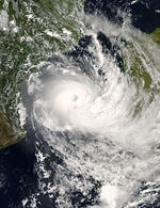
Shortly after attaining tropical cyclone status, Jokwe began weakening as its eye disappeared, and it weakened to tropical storm status. The weakening trend was short-lived, and after turning westward the storm re-developed a 13 km (8 mi) eye. Jokwe again underwent rapid intensification as it approached the coast of Mozambique
, becoming an intense "midget cyclone" with winds of 175 km/h (110 mph) late on March 7; the MFR explained its rapid intensity changes due to its small size. Excellent upper-level outflow and warm waters contributed to the intensification. At 0000 UTC
on March 8, Jokwe attained peak winds of 195 km/h (120 mph) about 75 km (45 mi) east of the Island of Mozambique
in Nampula Province
; at the same time, its gusts reached about 275 km/h (170 mph). It weakened slightly while paralleling the coastline just offshore, and at 1015 UTC Jokwe made landfall
between the Island of Mozambique and Angoche
.
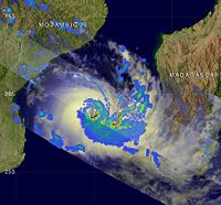
 Cyclone Jokwe remained over land for about 18 hours before emerging into the Mozambique Channel, weakening quickly to tropical storm status. Upon reaching open waters, convection increased over the center, and late on March 9 Jokwe re-intensified to a tropical cyclone as an eye reappeared on satellite imagery. The cyclone turned to the south-southeast, around the periphery of a ridge to its east. An upper-level low to its south produced good outflow which, in combination with warm waters, allowed Jokwe to re-intensify. Late on March 10, the storm passed about 35 km (21 mi) east of Europa Island
, and shortly thereafter the MFR upgraded Jokwe to intense tropical cyclone status with winds of 170 km/h (105 mph). Subsequently, an increase in wind shear caused a steady weakening trend, and by March 12 Jokwe weakened to tropical storm status as its center became partially exposed from the deep convection; at the same time, the storm turned to the southwest.
Later on March 12, thunderstorms reformed over the center, as its movement became nearly stationary due to a ridge to its south and northwest. Early on March 13, it began a steady movement to the northwest, and its organization increased with an eye re-appearing; after briefly re-attaining tropical cyclone status, Jokwe again weakened to tropical storm status due to persistent wind shear. Convection continued to diminish, and on March 14 Jokwe weakened to tropical depression status as the center became almost fully exposed. Early on March 15, the MFR issued its last advisory on the system. The remnants accelerated southeastward and dissipated on March 16 to the southwest of Madagascar.
 Crossing northern Madagascar
as a tropical storm, Jokwe damaged or destroyed 44 buildings in Nosy Be
, leaving 400 homeless. Satellite-based rainfall estimates reached over 200 mm (8 inches) in northwestern Madagascar.
On March 7, the National Emergency Operational Centre of Mozambique warned for coastal residents in Nampula
and Zambezia
provinces to be on alert. A day later, the agency issued a Red Alert for northern Nampula Province, advising potentially affected residents to seek shelter. Subsequently, the alert was extended southwestward along the coastline. Strong winds and heavy rains from the storm left the island of Mozambique
without power, as well as water. There winds knocked down several poorly constructed houses, and also destroyed the roofs of two schools. Satellite-based rainfall estimates reached over 300 mm (12 inches) in northwestern Madagascar. Across Nampula Province, heavy agricultural damage was reported; a total of 508 animals on farms were killed, and about 2 million cashew trees were destroyed. Widespread power outages were reported, with 75% of power transmission lines damaged or destroyed. The cyclone destroyed at least 200 boats and the roofs of at least 80 schools. The storm destroyed a bridge across the Mogincual River
, which left the town of Namige isolated. Across Nampula Province, Jokwe destroyed 9,316 houses and damaged 3,220 more, most of which in Angoche
. In Pebane District
in neighboring Zambezia Province
, the cyclone destroyed nine houses. Rainfall was reported throughout the province, though damage was not as heavy due to lack of strong winds. Throughout Mozambique, the cyclone affected 200,000 people, with a total of 55,000 people left homeless. Ten people were killed in Nampula Province, and six more were killed in coastal districts of Zambezia Province.
On March 10, a station on Europa Island
in the Mozambique Channel reported a pressure of 985.5 mbar
.
 Shortly after the cyclone moved ashore along Mozambique, officials distributed tents and food to the affected citizens. The government activated the National Civil Protection Unit to clear fallen trees from roadways, as well as assist in rebuilding damaged or destroyed homes. A few days after the storm, the Mozambique Red Cross
began delivering mosquito nets, blankets, plastic buckets, and sleeping mats. The government of Nampula estimated it would require $8 million (USD) to repair storm damage in the province.
Two weeks after the storm, the World Food Programme
announced it would provide food for 60,000 people in the impacted areas of Mozambique. On March 27, the government of Portugal
donated $700,000 (USD) to the Mozambique National Disasters Management Institute; over half of the total was aid for flood victims affected by Jokwe and flooding earlier in the year.
Tropical cyclone
A tropical cyclone is a storm system characterized by a large low-pressure center and numerous thunderstorms that produce strong winds and heavy rain. Tropical cyclones strengthen when water evaporated from the ocean is released as the saturated air rises, resulting in condensation of water vapor...
to make landfall
Landfall (meteorology)
Landfall is the event of a tropical cyclone or a waterspout coming onto land after being over water. When a waterspout makes landfall it is reclassified as a tornado, which can then cause damage inland...
in Mozambique
Mozambique
Mozambique, officially the Republic of Mozambique , is a country in southeastern Africa bordered by the Indian Ocean to the east, Tanzania to the north, Malawi and Zambia to the northwest, Zimbabwe to the west and Swaziland and South Africa to the southwest...
since Cyclone Favio struck in the previous year. The tenth named storm of the 2007-08 South-West Indian Ocean cyclone season
2007-08 South-West Indian Ocean cyclone season
The 2007–08 South-West Indian Ocean cyclone season was an event in the annual cycle of tropical cyclone formation. It began on November 15, 2007, and ended on April 30, 2008, with the exception for Mauritius and the Seychelles, which ended May 15...
, Jokwe was first classified as a tropical depression on March 2 over the open Southwest Indian Ocean
Indian Ocean
The Indian Ocean is the third largest of the world's oceanic divisions, covering approximately 20% of the water on the Earth's surface. It is bounded on the north by the Indian Subcontinent and Arabian Peninsula ; on the west by eastern Africa; on the east by Indochina, the Sunda Islands, and...
. It tracked west-southwest, crossing northern Madagascar
Madagascar
The Republic of Madagascar is an island country located in the Indian Ocean off the southeastern coast of Africa...
as a tropical storm on March 5 before intensifying into a tropical cyclone
Tropical cyclone scales
Tropical systems are officially ranked on one of several tropical cyclone scales according to their maximum sustained winds and in what oceanic basin they are located...
on March 6. Jokwe rapidly intensified to reach peak winds of 195 km/h (120 mph), before weakening slightly and striking Nampula Province
Nampula Province
Nampula is a province of Mozambique. It has an area of 81,606 km² and a population of 3.985.285 . Nampula is the capital of the province...
in northeastern Mozambique. It quickly weakened while paralleling the coastline, though the storm restrengthened as it turned southward in the Mozambique Channel. Late in its duration, it remained nearly stationary for several days, and steadily weakened due to wind shear
Wind shear
Wind shear, sometimes referred to as windshear or wind gradient, is a difference in wind speed and direction over a relatively short distance in the atmosphere...
before dissipating on March 16.
The storm caused minor damage in northern Madagascar. In Mozambique, the cyclone affected 200,000 people, and left at least sixteen fatalities. Cyclone Jokwe destroyed over 9,000 houses and damaged over 3,000 more, with the heaviest damage in Angoche
Angoche
Angoche is a city of Nampula Province in Mozambique. The city was named António Enes until 1976, after the 19th century Portuguese journalist and colonial administrator, António José Enes...
and the Island of Mozambique
Island of Mozambique
The Island of Mozambique lies off northern Mozambique, between the Mozambique Channel and Mossuril Bay. It has a population of around 14,000 people and is part of Nampula Province.-History:...
in Nampula Province. The storm also caused widespread power outages and crop damages. The name Jokwe was submitted to the World Meteorological Organization
World Meteorological Organization
The World Meteorological Organization is an intergovernmental organization with a membership of 189 Member States and Territories. It originated from the International Meteorological Organization , which was founded in 1873...
by Botswana
Botswana
Botswana, officially the Republic of Botswana , is a landlocked country located in Southern Africa. The citizens are referred to as "Batswana" . Formerly the British protectorate of Bechuanaland, Botswana adopted its new name after becoming independent within the Commonwealth on 30 September 1966...
.
Meteorological history
In the beginning of the month, an area of convection persisted in association with a broad low-level circulation about 565 km (350 mi) west-southwest of Diego GarciaDiego Garcia
Diego Garcia is a tropical, footprint-shaped coral atoll located south of the equator in the central Indian Ocean at 7 degrees, 26 minutes south latitude. It is part of the British Indian Ocean Territory [BIOT] and is positioned at 72°23' east longitude....
. The disturbance tracked west-southwestward, and on March 2 the Météo-France
Météo-France
Météo-France is the French national meteorological service.The organisation was established by decree in June 1993 and is a department of the Ministry of Transportation. It is headquartered in Paris but many domestic operations have been decentralised to Toulouse...
(MFR) declared it as a weak depression. Initially in an area of moderate wind shear
Wind shear
Wind shear, sometimes referred to as windshear or wind gradient, is a difference in wind speed and direction over a relatively short distance in the atmosphere...
, the system at first failed to maintain deep convection. Early on March 4, convection increased and organized around the center of circulation, and the MFR classified it as Tropical Depression Twelve, about 270 km (170 mi) southwest of the Agalega Islands
Agalega Islands
The Agalega Islands are two islands in the Indian Ocean, lying north of Mauritius at and are governed by that country. The islands have a total area of 24 km² , although the official figure of 70 km² appears too high when compared with data from satellite images.The North Island is home...
. Initially the MFR forecast that the depression would intensify further before striking Madagascar
Madagascar
The Republic of Madagascar is an island country located in the Indian Ocean off the southeastern coast of Africa...
.
The cyclone tracked generally westward along the northern periphery of a ridge
Ridge (meteorology)
A ridge is an elongated region of relatively high atmospheric pressure, the opposite of a trough....
. The circulation became better defined, though convection was displaced to the west of the center due to persistent wind shear. Intensification was favored, though, due to warm water temperatures and good outflow
Outflow (meteorology)
Outflow, in meteorology, is air that flows outwards from a storm system. It is associated with ridging, or anticyclonic flow. In the low levels of the troposphere, outflow radiates from thunderstorms in the form of a wedge of rain-cooled air, which is visible as a thin rope-like cloud on weather...
. Early on March 5, the Joint Typhoon Warning Center
Joint Typhoon Warning Center
The Joint Typhoon Warning Center is a joint United States Navy – United States Air Force task force located at the Naval Maritime Forecast Center in Pearl Harbor, Hawaii...
(JTWC) classified the system as Tropical Cyclone 22S. Shortly thereafter, the MFR upgraded the depression to Moderate Tropical Storm Jokwe about 675 km (420 mi) southwest of the Agalega Islands, or about 230 km (140 mi) northeast of the northern tip of Madagascar. At first, the storm was smaller than usual, with gale force winds extending 37 km (23 mi) from the center. Jokwe turned to the west-southwest in response to the development of a trough
Trough (meteorology)
A trough is an elongated region of relatively low atmospheric pressure, often associated with fronts.Unlike fronts, there is not a universal symbol for a trough on a weather chart. The weather charts in some countries or regions mark troughs by a line. In the United States, a trough may be marked...
of low pressure in the Mozambique Channel
Mozambique Channel
The Mozambique Channel is a portion of the Indian Ocean located between the island nation of Madagascar and southeast Africa, primarily the country of Mozambique. It was a World War II clashpoint during the Battle of Madagascar...
, and late on March 5 the storm crossed over northern Madagascar. The low-level circulation became disorganized due to land interaction, though its mid and upper-level circulation remained well-organized. Subsequently, the storm encountered more favorable conditions, and an eye
Eye (cyclone)
The eye is a region of mostly calm weather found at the center of strong tropical cyclones. The eye of a storm is a roughly circular area and typically 30–65 km in diameter. It is surrounded by the eyewall, a ring of towering thunderstorms where the second most severe weather of a cyclone...
developed; Jokwe underwent rapid deepening
Rapid deepening
Rapid deepening, also known as rapid intensification, is a meteorological condition that occurs when the minimum sea-level atmospheric pressure of a tropical cyclone decreases drastically in a short period of time. The National Weather Service describes rapid deepening as a decrease of...
and intensified to tropical cyclone
Tropical cyclone scales
Tropical systems are officially ranked on one of several tropical cyclone scales according to their maximum sustained winds and in what oceanic basin they are located...
status, or the equivalence of a minimal hurricane, midday on March 6 off the northwest coast of Madagascar.
Shortly after attaining tropical cyclone status, Jokwe began weakening as its eye disappeared, and it weakened to tropical storm status. The weakening trend was short-lived, and after turning westward the storm re-developed a 13 km (8 mi) eye. Jokwe again underwent rapid intensification as it approached the coast of Mozambique
Mozambique
Mozambique, officially the Republic of Mozambique , is a country in southeastern Africa bordered by the Indian Ocean to the east, Tanzania to the north, Malawi and Zambia to the northwest, Zimbabwe to the west and Swaziland and South Africa to the southwest...
, becoming an intense "midget cyclone" with winds of 175 km/h (110 mph) late on March 7; the MFR explained its rapid intensity changes due to its small size. Excellent upper-level outflow and warm waters contributed to the intensification. At 0000 UTC
Coordinated Universal Time
Coordinated Universal Time is the primary time standard by which the world regulates clocks and time. It is one of several closely related successors to Greenwich Mean Time. Computer servers, online services and other entities that rely on having a universally accepted time use UTC for that purpose...
on March 8, Jokwe attained peak winds of 195 km/h (120 mph) about 75 km (45 mi) east of the Island of Mozambique
Island of Mozambique
The Island of Mozambique lies off northern Mozambique, between the Mozambique Channel and Mossuril Bay. It has a population of around 14,000 people and is part of Nampula Province.-History:...
in Nampula Province
Nampula Province
Nampula is a province of Mozambique. It has an area of 81,606 km² and a population of 3.985.285 . Nampula is the capital of the province...
; at the same time, its gusts reached about 275 km/h (170 mph). It weakened slightly while paralleling the coastline just offshore, and at 1015 UTC Jokwe made landfall
Landfall (meteorology)
Landfall is the event of a tropical cyclone or a waterspout coming onto land after being over water. When a waterspout makes landfall it is reclassified as a tornado, which can then cause damage inland...
between the Island of Mozambique and Angoche
Angoche
Angoche is a city of Nampula Province in Mozambique. The city was named António Enes until 1976, after the 19th century Portuguese journalist and colonial administrator, António José Enes...
.
Europa Island
Europa Island is a 28 km² low-lying tropical island in the Mozambique Channel, about a third of the way from southern Madagascar to southern Mozambique, at . It has 22.2 kilometres of coastline, but no ports or harbours. Anchorage is possible offshore...
, and shortly thereafter the MFR upgraded Jokwe to intense tropical cyclone status with winds of 170 km/h (105 mph). Subsequently, an increase in wind shear caused a steady weakening trend, and by March 12 Jokwe weakened to tropical storm status as its center became partially exposed from the deep convection; at the same time, the storm turned to the southwest.
Later on March 12, thunderstorms reformed over the center, as its movement became nearly stationary due to a ridge to its south and northwest. Early on March 13, it began a steady movement to the northwest, and its organization increased with an eye re-appearing; after briefly re-attaining tropical cyclone status, Jokwe again weakened to tropical storm status due to persistent wind shear. Convection continued to diminish, and on March 14 Jokwe weakened to tropical depression status as the center became almost fully exposed. Early on March 15, the MFR issued its last advisory on the system. The remnants accelerated southeastward and dissipated on March 16 to the southwest of Madagascar.
Impact
Madagascar
The Republic of Madagascar is an island country located in the Indian Ocean off the southeastern coast of Africa...
as a tropical storm, Jokwe damaged or destroyed 44 buildings in Nosy Be
Nosy Be
Nosy Be is an island located off the northwest coast of Madagascar. Nosy Be is Madagascar's largest and busiest tourist resort. It has an area of 312 km2 and its population was officially estimated at 36,636 in 2001....
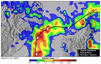
, leaving 400 homeless. Satellite-based rainfall estimates reached over 200 mm (8 inches) in northwestern Madagascar.
On March 7, the National Emergency Operational Centre of Mozambique warned for coastal residents in Nampula
Nampula Province
Nampula is a province of Mozambique. It has an area of 81,606 km² and a population of 3.985.285 . Nampula is the capital of the province...
and Zambezia
Zambezia Province
Zambezia is the most-populous province of Mozambique, located in the central coastal region south-west of Nampula Province and north-east of Sofala Province. It has a population of 3,794,509 . The provincial capital is Quelimane on the Bons Sinais River.Zambezia has a total area of...
provinces to be on alert. A day later, the agency issued a Red Alert for northern Nampula Province, advising potentially affected residents to seek shelter. Subsequently, the alert was extended southwestward along the coastline. Strong winds and heavy rains from the storm left the island of Mozambique
Island of Mozambique
The Island of Mozambique lies off northern Mozambique, between the Mozambique Channel and Mossuril Bay. It has a population of around 14,000 people and is part of Nampula Province.-History:...
without power, as well as water. There winds knocked down several poorly constructed houses, and also destroyed the roofs of two schools. Satellite-based rainfall estimates reached over 300 mm (12 inches) in northwestern Madagascar. Across Nampula Province, heavy agricultural damage was reported; a total of 508 animals on farms were killed, and about 2 million cashew trees were destroyed. Widespread power outages were reported, with 75% of power transmission lines damaged or destroyed. The cyclone destroyed at least 200 boats and the roofs of at least 80 schools. The storm destroyed a bridge across the Mogincual River
Mogincual District
Mogincual District is a district of Nampula Province in north-eastern Mozambique. The principal town is Mogincual.-Further reading:*...
, which left the town of Namige isolated. Across Nampula Province, Jokwe destroyed 9,316 houses and damaged 3,220 more, most of which in Angoche
Angoche
Angoche is a city of Nampula Province in Mozambique. The city was named António Enes until 1976, after the 19th century Portuguese journalist and colonial administrator, António José Enes...
. In Pebane District
Pebane District
-Further reading:*...
in neighboring Zambezia Province
Zambezia Province
Zambezia is the most-populous province of Mozambique, located in the central coastal region south-west of Nampula Province and north-east of Sofala Province. It has a population of 3,794,509 . The provincial capital is Quelimane on the Bons Sinais River.Zambezia has a total area of...
, the cyclone destroyed nine houses. Rainfall was reported throughout the province, though damage was not as heavy due to lack of strong winds. Throughout Mozambique, the cyclone affected 200,000 people, with a total of 55,000 people left homeless. Ten people were killed in Nampula Province, and six more were killed in coastal districts of Zambezia Province.
On March 10, a station on Europa Island
Europa Island
Europa Island is a 28 km² low-lying tropical island in the Mozambique Channel, about a third of the way from southern Madagascar to southern Mozambique, at . It has 22.2 kilometres of coastline, but no ports or harbours. Anchorage is possible offshore...
in the Mozambique Channel reported a pressure of 985.5 mbar
Bar (unit)
The bar is a unit of pressure equal to 100 kilopascals, and roughly equal to the atmospheric pressure on Earth at sea level. Other units derived from the bar are the megabar , kilobar , decibar , centibar , and millibar...
.
Aftermath
International Red Cross and Red Crescent Movement
The International Red Cross and Red Crescent Movement is an international humanitarian movement with approximately 97 million volunteers, members and staff worldwide which was founded to protect human life and health, to ensure respect for all human beings, and to prevent and alleviate human...
began delivering mosquito nets, blankets, plastic buckets, and sleeping mats. The government of Nampula estimated it would require $8 million (USD) to repair storm damage in the province.
Two weeks after the storm, the World Food Programme
World Food Programme
The World Food Programme is the food aid branch of the United Nations, and the world's largest humanitarian organization addressing hunger worldwide. WFP provides food, on average, to 90 million people per year, 58 million of whom are children...
announced it would provide food for 60,000 people in the impacted areas of Mozambique. On March 27, the government of Portugal
Portugal
Portugal , officially the Portuguese Republic is a country situated in southwestern Europe on the Iberian Peninsula. Portugal is the westernmost country of Europe, and is bordered by the Atlantic Ocean to the West and South and by Spain to the North and East. The Atlantic archipelagos of the...
donated $700,000 (USD) to the Mozambique National Disasters Management Institute; over half of the total was aid for flood victims affected by Jokwe and flooding earlier in the year.
See also
- List of tropical cyclones
- Timeline of the 2007–08 South-West Indian Ocean cyclone season