

Croydon parks and open spaces
Encyclopedia
London Borough of Croydon
The London Borough of Croydon is a London borough in South London, England and is part of Outer London. It covers an area of and is the largest London borough by population. It is the southernmost borough of London. At its centre is the historic town of Croydon from which the borough takes its name...
has over 120 parks and open spaces within its boundaries, ranging from the 200 acre (80ha) Selsdon Wood
Selsdon Wood
Selsdon Wood is a woodland area located in the London Borough of Croydon. The park is owned by the National Trust but managed by the London Borough of Croydon. It is a Local Nature Reserve....
Nature Reserve
Nature reserve
A nature reserve is a protected area of importance for wildlife, flora, fauna or features of geological or other special interest, which is reserved and managed for conservation and to provide special opportunities for study or research...
to many recreation grounds and sports fields scattered throughout the Borough. Croydon covers an area of 86.52 km², the 256th largest district in England. Croydon's physical features consist of many hills and rivers that are spread out across the borough and into the North Downs
North Downs
The North Downs are a ridge of chalk hills in south east England that stretch from Farnham in Surrey to the White Cliffs of Dover in Kent. The North Downs lie within two Areas of Outstanding Natural Beauty , the Surrey Hills and the Kent Downs...
, Surrey
Surrey
Surrey is a county in the South East of England and is one of the Home Counties. The county borders Greater London, Kent, East Sussex, West Sussex, Hampshire and Berkshire. The historic county town is Guildford. Surrey County Council sits at Kingston upon Thames, although this has been part of...
and the rest of South London. Some of the open spaces in Croydon form part of the well-known London LOOP walks where the first section was opened on May 3, 1996, with a ceremony on Farthing Downs in Coulsdon
Coulsdon
Coulsdon is a town on the southernmost boundary of the London Borough of Croydon. It is surrounded by the Metropolitan Green Belt of the Farthing Down, Coulsdon Common and Kenley Common...
. As a borough in Outer London it also contains some open countryside in the form of country parks. Croydon Council is associated with several other boroughs who are taking part in the Downlands Countryside Management Project
Downlands Countryside Management Project
The Downlands Countryside Management Project established in 1988 is a partnership between six London and Surrey local authorities set up to manage an area of countryside of 130 km² across the south of Outer London....
. These boroughs are Sutton
London Borough of Sutton
The London Borough of Sutton is a London borough in South London, England and forms part of Outer London. It covers an area of and is the 80th largest local authority in England by population. It is one of the southernmost boroughs of London...
; and by Surrey County Council
Surrey
Surrey is a county in the South East of England and is one of the Home Counties. The county borders Greater London, Kent, East Sussex, West Sussex, Hampshire and Berkshire. The historic county town is Guildford. Surrey County Council sits at Kingston upon Thames, although this has been part of...
; the City of London Corporation; the Surrey districts of Reigate and Banstead
Reigate and Banstead
Reigate and Banstead is a local government district with borough status in east Surrey England. It covers the towns of Reigate, Banstead, Redhill and Horley....
and Tandridge; and the Countryside Agency
Countryside Agency
The Countryside Agency in England was a statutory body set up in 1999 with the task of improving the quality of the rural environment and the lives of those living in it. The Agency was formed by merging the Countryside Commission and the Rural Development Commission...
. An additional partner is Natural Britain.
Duppas Hill
Duppas Hill
Duppas Hill is a park, road and surrounding residential area in Waddon, near Croydon in Greater London . It is thought to be named after a family called 'Dubber' or 'Double'.Duppas Hill has a long history of sport and recreation...
was Croydon's first public recreation ground, bought by the Board of Health in 1865. Addington Hills
Addington Hills
Addington Hills is a park in Upper Shirley, London, England. It is managed by the London Borough of Croydon. It was part of the old parish of Addington before the suburb of Shirley was developed in the 1930s. The site consists largely of woodland on a gravel bed, with London's largest area of...
is a major floodplain
Floodplain
A floodplain, or flood plain, is a flat or nearly flat land adjacent a stream or river that stretches from the banks of its channel to the base of the enclosing valley walls and experiences flooding during periods of high discharge...
in London for the Thames Valley
Thames Valley
The Thames Valley Region is a loose term for the English counties and towns roughly following the course of the River Thames as it flows from Oxfordshire in the west to London in the east. It includes parts of Buckinghamshire, Berkshire, North Hampshire, Surrey and west London...
and is recognised as a significant obstacle to the growth of London from its origins as a port on the north side of the river, to a large circular city. Mitcham Common
Mitcham Common
Mitcham Common or Seven Islands is 182 hectares of common land situated in South London. It is predominantly in the London borough of Merton, with parts straddling the borders with Sutton and Croydon.- History :...
also forms part of the borough although it is only partly in Croydon, the London Borough of Merton
London Borough of Merton
The London Borough of Merton is a borough in southwest London, England.The borough was formed under the London Government Act in 1965 by the merger of the Municipal Borough of Mitcham, the Municipal Borough of Wimbledon and the Merton and Morden Urban District, all formerly within Surrey...
has the dominant half of the common, while Sutton
London Borough of Sutton
The London Borough of Sutton is a London borough in South London, England and forms part of Outer London. It covers an area of and is the 80th largest local authority in England by population. It is one of the southernmost boroughs of London...
make up most of the south side.
The Queen's Gardens
Queen's Gardens (Croydon)
The Queen's Gardens are a small area of urban gardens in the centre of Croydon, South London. It is part of the Croydon Vision 2020 re-generation plan with Park Place. They are bordered by Croydon Town Hall, Taberner house, Park Lane and Katharine Street....
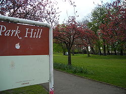
, Park Hill and Norwood Grove are examples of ornamental gardens in the Borough.
There are also many recreation grounds such as the one in South Norwood
South Norwood Recreation Ground
South Norwood Recreation Ground is a park located in South Norwood in the London Borough of Croydon. This recreation ground was acquired by the council in 1889 and the Borough Road Surveyor estimated that it would cost £1,326. 19s. 6d. to lay out...
which is currently undergoing major refurbishment works. Examples of meadows include Heavers Meadow
Heavers Meadow
Heavers Meadow is a meadow located in South Norwood and Selhurst in the London Borough of Croydon. South Norwood Recreation Ground is on the other side of the road. The meadow covers an area of 8 3/4 acres . With meadows there are not usually many facilities...
and Brickfields Meadow
Brickfields Meadow
Brickfields Meadow is a meadow in South Norwood in the London Borough of Croydon. It is located on the former site of a brickworks in Tennison Road and Dickensons Lane in Woodside. The meadow covers an area of about 4.37 hectares...
both located in South Norwood
South Norwood
South Norwood is an urban town and in south London, England, in the London Borough of Croydon. It is a suburban development 7.8 miles south-east of Charing Cross. South Norwood is an electoral with a resident population in 2001 of just over 14,000...
.
History
The Great North WoodGreat North Wood
The Great North Wood was a natural oak forest that covered most of the area of raised ground starting some four miles south of central London, covering the Sydenham Ridge and the southern reaches of the River Effra and its tributaries...
was a natural oak forest that covered the Sydenham Ridge
Sydenham
Sydenham is an area and electoral ward in the London Borough of Lewisham; although some streets towards Crystal Palace Park, Forest Hill and Penge are outside the ward and in the London Borough of Bromley, and some streets off Sydenham Hill are in the London Borough of Southwark. Sydenham was in...
and the southern reaches of the River Effra
River Effra
The River Effra is a river in south London, England. It is now mainly underground. The name cannot be traced back much earlier than 1840 , so speculation that it came from a Celtic word for torrent is unwarranted...
and its tributaries. It is a major part of the history of Croydon. The most notable tree, called Vicar's Oak, marked the boundary of four ancient parishes; Lambeth
Lambeth
Lambeth is a district of south London, England, and part of the London Borough of Lambeth. It is situated southeast of Charing Cross.-Toponymy:...
, Camberwell
Camberwell
Camberwell is a district of south London, England, and forms part of the London Borough of Southwark. It is a built-up inner city district located southeast of Charing Cross. To the west it has a boundary with the London Borough of Lambeth.-Toponymy:...
, Croydon and Bromley
Bromley
Bromley is a large suburban town in south east London, England and the administrative headquarters of the London Borough of Bromley. It was historically a market town, and prior to 1963 was in the county of Kent and formed the administrative centre of the Municipal Borough of Bromley...
. John Aubrey referred to this "ancient remarkable tree" in the past tense as early as 1718, but according to JB Wilson, the Vicar's Oak survived until 1825. The earliest surviving mention of the wood dates from assize records in 1272, and it was known to be owned by the Whitehorse family during the reign of King Edward III. When Oliver Cromwell
Oliver Cromwell
Oliver Cromwell was an English military and political leader who overthrew the English monarchy and temporarily turned England into a republican Commonwealth, and served as Lord Protector of England, Scotland, and Ireland....
seized it from the Archbishop of Canterbury
Archbishop of Canterbury
The Archbishop of Canterbury is the senior bishop and principal leader of the Church of England, the symbolic head of the worldwide Anglican Communion, and the diocesan bishop of the Diocese of Canterbury. In his role as head of the Anglican Communion, the archbishop leads the third largest group...
it was measured to cover 830 acres (3.4 km²), but held only 9,200 oaken pollards. At this time it was known to stretch as far as Streatham
Streatham
Streatham is a district in Surrey, England, located in the London Borough of Lambeth. It is situated south of Charing Cross. The area is identified in the London Plan as one of 35 major centres in Greater London.-History:...
from Croydon. Much timber was taken from the woodlands for use in the Royal Dockyard at Deptford
Deptford
Deptford is a district of south London, England, located on the south bank of the River Thames. It is named after a ford of the River Ravensbourne, and from the mid 16th century to the late 19th was home to Deptford Dockyard, the first of the Royal Navy Dockyards.Deptford and the docks are...
as well for charcoal
Charcoal
Charcoal is the dark grey residue consisting of carbon, and any remaining ash, obtained by removing water and other volatile constituents from animal and vegetation substances. Charcoal is usually produced by slow pyrolysis, the heating of wood or other substances in the absence of oxygen...
burning and building purposes. Much of the surviving woodlands were cleared and developed as a result of the 1797 Croydon Inclosure Act
Inclosure Act
The Inclosure or Enclosure Acts were a series of United Kingdom Acts of Parliament which enclosed open fields and common land in the country. They removed previously existing rights of local people to carry out activities in these areas, such as cultivation, cutting hay, grazing animals or using...
and sale of the late Lord Thurlow's estates in 1806, although some substantial fragments remain, notably the nature reserves at Dulwich Wood
Dulwich Wood
Dulwich Wood together with the adjacent Sydenham Hill Wood is the largest extant part of the ancient Great North Wood. The two woods were separated after the relocation of The Crystal Palace in 1854 and the creation of the high level line in 1865...
and Sydenham Hill Wood
Sydenham Hill Wood
The nine-hectare Sydenham Hill Wood, is situated on the northern slopes of the Norwood Ridge in the London Borough of Southwark, and is an important wildlife site. Together with the adjacent Dulwich Wood , Sydenham Hill Wood is the largest extant tract of the ancient Great North Wood...
.
Principal open spaces
Apart from smaller green areas such as sports grounds and smaller gardens, and Selsdon WoodSelsdon Wood
Selsdon Wood is a woodland area located in the London Borough of Croydon. The park is owned by the National Trust but managed by the London Borough of Croydon. It is a Local Nature Reserve....
, which is National Trust
National Trust for Places of Historic Interest or Natural Beauty
The National Trust for Places of Historic Interest or Natural Beauty, usually known as the National Trust, is a conservation organisation in England, Wales and Northern Ireland...
property, the following are the major open spaces in the Borough:
Croydon North
- South Norwood Country ParkSouth Norwood Country ParkSouth Norwood Country Park is a park in South Norwood, close to Elmers End station, mainly in the London Borough of Croydon. It is a 47 hectare green space which opened in 1989...
, South NorwoodSouth NorwoodSouth Norwood is an urban town and in south London, England, in the London Borough of Croydon. It is a suburban development 7.8 miles south-east of Charing Cross. South Norwood is an electoral with a resident population in 2001 of just over 14,000...
: former sewage farm, 125 acres (50ha) - South Norwood Lake and GroundsSouth Norwood Lake and GroundsSouth Norwood Lake and Grounds is a park in South Norwood in the London Borough of Croydon. The main entrance is in Woodvale Avenue while other entrances are located in Auckland Road and Sylvan Road. The area measures up to 28 acres 11.53 hectares....
, South NorwoodSouth NorwoodSouth Norwood is an urban town and in south London, England, in the London Borough of Croydon. It is a suburban development 7.8 miles south-east of Charing Cross. South Norwood is an electoral with a resident population in 2001 of just over 14,000...
: large lake land and green space area, 28 acres (11ha)
Croydon Central
- Lloyd Park, CroydonCroydonCroydon is a town in South London, England, located within the London Borough of Croydon to which it gives its name. It is situated south of Charing Cross...
: founded by Frank Lloyd, 114 acres (46ha) - Addington HillsAddington HillsAddington Hills is a park in Upper Shirley, London, England. It is managed by the London Borough of Croydon. It was part of the old parish of Addington before the suburb of Shirley was developed in the 1930s. The site consists largely of woodland on a gravel bed, with London's largest area of...
, AddingtonAddington, LondonAddington is a district of south London, England, located in the London Borough of Croydon. It is situated south south-east of Charing Cross.-History:...
: also named Shirley Hills - Queen's GardensQueen's Gardens (Croydon)The Queen's Gardens are a small area of urban gardens in the centre of Croydon, South London. It is part of the Croydon Vision 2020 re-generation plan with Park Place. They are bordered by Croydon Town Hall, Taberner house, Park Lane and Katharine Street....
, Central CroydonCroydonCroydon is a town in South London, England, located within the London Borough of Croydon to which it gives its name. It is situated south of Charing Cross...
: urban park next to the Croydon ClocktowerCroydon ClocktowerCroydon Clocktower on Katharine Street in Croydon is an arts centre in London, England. It contains the Museum of Croydon, the Riesco Gallery with a collection of Chinese pottery and ceramics, the David Lean Cinema, the Braithwaite Hall used for concerts and conferences, and a café and bar... - Duppas HillDuppas HillDuppas Hill is a park, road and surrounding residential area in Waddon, near Croydon in Greater London . It is thought to be named after a family called 'Dubber' or 'Double'.Duppas Hill has a long history of sport and recreation...
, WaddonWaddonWaddon is a place in the London Borough of Croydon, to the south west of central Croydon on the borders of the London Borough of Sutton. Waddon has an older area with 19th century properties, some even older, close to central Croydon. Further south is a large estate of Council-owned homes and a...
: also named Shirley Hills - Addington ValeAddington ValeAddington Vale is a park situated in New Addington in the London Borough of Croydon. The park is located on the two Milne Park roads . It extends from King Henry's Drive in the north to Arnhem Drive in the south, Queen Elizabeth's Drive runs along the western side, and Godric Crescent and Hares...
, AddingtonAddington, LondonAddington is a district of south London, England, located in the London Borough of Croydon. It is situated south south-east of Charing Cross.-History:...
: former green belt land, public open space in 1963, 48 acres (19ha) - Mitcham CommonMitcham CommonMitcham Common or Seven Islands is 182 hectares of common land situated in South London. It is predominantly in the London borough of Merton, with parts straddling the borders with Sutton and Croydon.- History :...
, MertonLondon Borough of MertonThe London Borough of Merton is a borough in southwest London, England.The borough was formed under the London Government Act in 1965 by the merger of the Municipal Borough of Mitcham, the Municipal Borough of Wimbledon and the Merton and Morden Urban District, all formerly within Surrey...
: area of large common land, 460 acres (182ha) - Millstock, HooleyHooleyHooley is a small village in Surrey, England. It lies in a "pass" which is the lowest crossing point of the North Downs for some distance in either direction. Both the London, Brighton and South Coast Railway and the South Eastern Railway recognised this pass as the best route to Brighton and built...
: "passMountain passA mountain pass is a route through a mountain range or over a ridge. If following the lowest possible route, a pass is locally the highest point on that route...
" of North DownsNorth DownsThe North Downs are a ridge of chalk hills in south east England that stretch from Farnham in Surrey to the White Cliffs of Dover in Kent. The North Downs lie within two Areas of Outstanding Natural Beauty , the Surrey Hills and the Kent Downs...
lowest for several kilometers, 60 acres (23ha) - Purley Way Playing Fields, WaddonWaddonWaddon is a place in the London Borough of Croydon, to the south west of central Croydon on the borders of the London Borough of Sutton. Waddon has an older area with 19th century properties, some even older, close to central Croydon. Further south is a large estate of Council-owned homes and a...
: large green space next to the Croydon ColonnadesColonnades Leisure ParkThe Colonnades Leisure Park is an out-of-town leisure park located in the Purley Way retail and industrial district of the London Borough of Croydon, South London which opened in the late 1990s...
, 109 acres (43.81ha)
Croydon South
- Happy Valley, Old CoulsdonOld CoulsdonOld Coulsdon is a small village near Coulsdon in London, England and part of the London Borough of Croydon.The nearest station is Coulsdon South.-Schools:*****Oasis Academy Coulsdon was formerly Coulsdon High School...
: countryside area, 252 acres (101ha) - Farthing DownsFarthing DownsFarthing Downs is an open space in Coulsdon in the London Borough of Croydon. Together with New Hill to the south-east, it is owned and managed by the Corporation of London. It is also part of the Farthing Downs and Happy Valley Site of Special Scientific Interest, notified in 1975. Happy Valley is...
, CoulsdonCoulsdonCoulsdon is a town on the southernmost boundary of the London Borough of Croydon. It is surrounded by the Metropolitan Green Belt of the Farthing Down, Coulsdon Common and Kenley Common...
: another countryside area in the borough, notable for its walking trails - Foxley Wood, PurleyPurley, LondonPurley is a place in the London Borough of Croydon, England. It is a suburban development situated 11.7 miles south of Charing Cross.The name derives from "pirlea", which means 'Peartree lea'. Purley has a population of about 72,000....
: An ancient urban woodland with Nature Reserve status noted for its diversity of flora and wildlife encompassed in an urban location featuring a nature trail. The Friends of Foxley in association with London Borough of CroydonLondon Borough of CroydonThe London Borough of Croydon is a London borough in South London, England and is part of Outer London. It covers an area of and is the largest London borough by population. It is the southernmost borough of London. At its centre is the historic town of Croydon from which the borough takes its name...
manage the woodland.http://www.friendsoffoxley.co.uk
Water
The River WandleRiver Wandle
The River Wandle is a river in south-east England. The names of the river and of Wandsworth are thought to have derived from the Old English "Wendlesworth" meaning "Wendle's Settlement". The river runs through southwest London and is about long...
is also a major tributary of the River Thames
River Thames
The River Thames flows through southern England. It is the longest river entirely in England and the second longest in the United Kingdom. While it is best known because its lower reaches flow through central London, the river flows alongside several other towns and cities, including Oxford,...
, where it stretches to Wandsworth
Wandsworth
Wandsworth is a district of south London, England, in the London Borough of Wandsworth. It is situated southwest of Charing Cross. The area is identified in the London Plan as one of 35 major centres in Greater London.-Toponymy:...
and Putney
Putney
Putney is a district in south-west London, England, located in the London Borough of Wandsworth. It is situated south-west of Charing Cross. The area is identified in the London Plan as one of 35 major centres in Greater London....
for 9 miles (14 km) from its main source in Waddon
Waddon
Waddon is a place in the London Borough of Croydon, to the south west of central Croydon on the borders of the London Borough of Sutton. Waddon has an older area with 19th century properties, some even older, close to central Croydon. Further south is a large estate of Council-owned homes and a...
. It forms a rough western boundary with the London Borough of Sutton
London Borough of Sutton
The London Borough of Sutton is a London borough in South London, England and forms part of Outer London. It covers an area of and is the 80th largest local authority in England by population. It is one of the southernmost boroughs of London...
, and for part of its length forms the boundary between the London Boroughs of Croydon and Lambeth
London Borough of Lambeth
The London Borough of Lambeth is a London borough in south London, England and forms part of Inner London. The local authority is Lambeth London Borough Council.-Origins:...
The main river ends at Waddon
Waddon
Waddon is a place in the London Borough of Croydon, to the south west of central Croydon on the borders of the London Borough of Sutton. Waddon has an older area with 19th century properties, some even older, close to central Croydon. Further south is a large estate of Council-owned homes and a...
with one of its tributaries ending in Selhurst
Selhurst
Selhurst is a suburban development in the London Borough of Croydon south-south-east of Charing Cross. A relatively small area, Selhurst is bounded by South Norwood, Croydon and Thornton Heath and, like nearby Broad Green, has lost its distinct identity from these larger neighbours in recent years...
. Another tributary
Tributary
A tributary or affluent is a stream or river that flows into a main stem river or a lake. A tributary does not flow directly into a sea or ocean...
starts in Thornton Heath
Thornton Heath
Thornton Heath is a district of south London, England, in the London Borough of Croydon. It is situated south-southeast of Charing Cross.-Geography:...
as the Norbury Brook
Norbury Brook
A tributary of the River Wandle, Norbury Brook rises near Lower Addiscombe Road and flows north-west through Selhurst, Thornton Heath and Norbury to join the Wandle at south Wimbledon....
, becomes the River Graveney and joins the Wandle near Summerstown.
The Wandle park is one of 11 parks throughout Greater London
Greater London
Greater London is the top-level administrative division of England covering London. It was created in 1965 and spans the City of London, including Middle Temple and Inner Temple, and the 32 London boroughs. This territory is coterminate with the London Government Office Region and the London...
chosen to receive money for redevelopment by a public vote. The park received £400,000 towards better footpaths, more lighting, refurbished public toilets and new play areas for children.
Climate
The amount of green spaces in area can affect the climate of that particular area. Croydon has a temperateTemperate
In geography, temperate or tepid latitudes of the globe lie between the tropics and the polar circles. The changes in these regions between summer and winter are generally relatively moderate, rather than extreme hot or cold...
climate in common with most areas of Great Britain
Great Britain
Great Britain or Britain is an island situated to the northwest of Continental Europe. It is the ninth largest island in the world, and the largest European island, as well as the largest of the British Isles...
, it is similar to that of Greenwich
Greenwich
Greenwich is a district of south London, England, located in the London Borough of Greenwich.Greenwich is best known for its maritime history and for giving its name to the Greenwich Meridian and Greenwich Mean Time...
in Inner London
Inner London
Inner London is the name for the group of London boroughs which form the interior part of Greater London and are surrounded by Outer London. The area was first officially defined in 1965 and for purposes such as statistics, the definition has changed over time. The terms Inner London and Central...
: its Koppen climate classification is Cfb. Its mean annual temperature of 9.6 °C is similar to that experienced throughout the Weald, and slightly cooler than nearby areas such as the Sussex coast and Central London. Rainfall is considerably below England's average (1971–2000) level of 838 mm, and every month is drier overall than the England average.
See also
- List of parks and open spaces in Croydon
- Parks and open spaces in LondonParks and open spaces in LondonThere are many parks and open spaces in London, England. Green space in central London consists of five Royal Parks, supplemented by a number of small garden squares scattered throughout the city centre...
Please check the temperature numbers--they are inconsistent i.e. November low is "higher" than the high temp. Also, a number of the celsius temps are inverted.