

River Effra
Encyclopedia

London
London is the capital city of :England and the :United Kingdom, the largest metropolitan area in the United Kingdom, and the largest urban zone in the European Union by most measures. Located on the River Thames, London has been a major settlement for two millennia, its history going back to its...
, England
England
England is a country that is part of the United Kingdom. It shares land borders with Scotland to the north and Wales to the west; the Irish Sea is to the north west, the Celtic Sea to the south west, with the North Sea to the east and the English Channel to the south separating it from continental...
. It is now mainly underground. The name cannot be traced back much earlier than 1840 , so speculation that it came from a Celtic
British language
The British language was an ancient Celtic language spoken in Britain.British language may also refer to:* Any of the Languages of the United Kingdom.*The Welsh language or the Brythonic languages more generally* British English...
word for torrent is unwarranted. Probably it is also unrelated to the heah yfre 'high bank' at the river mouth mentioned in an Anglo-Saxon charter.
When the London sewerage system
London sewerage system
The London sewerage system is part of the water infrastructure serving London. The modern system was developed during the late 19th century, and as London has grown the system has been expanded.-History:...
was constructed during the mid-19th century, its designer Sir Joseph Bazalgette
Joseph Bazalgette
Sir Joseph William Bazalgette, CB was an English civil engineer of the 19th century. As chief engineer of London's Metropolitan Board of Works his major achievement was the creation of a sewer network for central London which was instrumental in relieving the city from cholera epidemics, while...
incorporated flows from the River Effra into his 'high-level interceptor sewer', also known as the Effra sewer
Sanitary sewer
A sanitary sewer is a separate underground carriage system specifically for transporting sewage from houses and commercial buildings to treatment or disposal. Sanitary sewers serving industrial areas also carry industrial wastewater...
, running from Herne Hill
Herne Hill
Herne Hill is located in the London Borough of Lambeth and the London Borough of Southwark in Greater London. There is a road of the same name which continues the A215 north of Norwood Road and was called Herne Hill Road.-History:...
eastwards under Peckham
Peckham
Peckham is a district in south London, England, located in the London Borough of Southwark. It is situated south-east of Charing Cross. The area is identified in the London Plan as one of 35 major centres in Greater London...
and New Cross
New Cross
New Cross is a district and ward of the London Borough of Lewisham, England. It is situated 4 miles south-east of Charing Cross. The ward covered by London post town and the SE 14 postcode district. New Cross is near St Johns, Telegraph Hill, Nunhead, Peckham, Brockley, Deptford and Greenwich...
to Deptford
Deptford
Deptford is a district of south London, England, located on the south bank of the River Thames. It is named after a ford of the River Ravensbourne, and from the mid 16th century to the late 19th was home to Deptford Dockyard, the first of the Royal Navy Dockyards.Deptford and the docks are...
.
The main course of the River Effra was diverted into a sewer and culvert
Culvert
A culvert is a device used to channel water. It may be used to allow water to pass underneath a road, railway, or embankment. Culverts can be made of many different materials; steel, polyvinyl chloride and concrete are the most common...
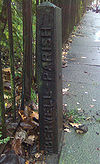
s. It can be accessed through the sewers on Effra Road in Brixton
Brixton
Brixton is a district in the London Borough of Lambeth in south London, England. It is south south-east of Charing Cross. The area is identified in the London Plan as one of 35 major centres in Greater London....
, South London and through a drainage grate in the crypts under St. Luke's Church, West Norwood
West Norwood
West Norwood is a place in the London Borough of Lambeth.It is primarily a residential suburb of south London but with some light industry near Knights Hill in the south....
, South London.
The route of the Effra
One branch of the Effra rises near Harold Road in Upper Norwood Recreation Ground, Crystal Palace, LondonCrystal Palace, London
Crystal Palace is a residential area in south London, England named from the former local landmark, The Crystal Palace, which occupied the area from 1854 to 1936. The area is located approximately 8 miles south east of Charing Cross, and offers impressive views over the capital...
, and flows through West Norwood where it is joined by a local tributary from Knights Hill Ward.
A second branch flows into West Dulwich
West Dulwich
West Dulwich is an area in southeast London, England, that straddles the London Borough of Lambeth and the London Borough of Southwark. Croxted Road and South Croxted Road mark the boundary between London Borough of Southwark on the east and London Borough of Lambeth to the west...
alongside Gipsy Hill
Gipsy Hill
Gipsy Hill is an area of South London near Upper Norwood, it is considered to be part of Crystal Palace. This area of Gipsy Hill also includes the Central Hill estate...
, which it joins at a junction with Dulwich Wood Avenue, after flowing downhill from near the Westow House pub at the eastern end of Westow Hill via Jasper Passage and the lower end of Colby Road. After picking up a tributary at Hamilton Road beyond The Mansion Pub (formerly called the Paxton
Paxton
-United Kingdom:* Great Paxton, England* Little Paxton, England* Paxton, Scottish Borders, UK* Paxton House, Berwickshire, Scotland* Paxton's Tower, near the National Botanic Garden of Wales in Carmarthenshire, Wales-United States:* Paxton, California...
Pub) at the junction where Gipsy Road, Alleyn Park and Gipsy Hill meet, this route meanders under Clive Road in the far West of West Dulwich
West Dulwich
West Dulwich is an area in southeast London, England, that straddles the London Borough of Lambeth and the London Borough of Southwark. Croxted Road and South Croxted Road mark the boundary between London Borough of Southwark on the east and London Borough of Lambeth to the west...
. It eventually joins the other branch near the South Circular and Croxted
Croxted
The Croxted was an English automobile built from 1904 to 1905 in Herne Hill, South London. The cars were available with either a 10hp engine or a power unit of 14hp and four cylinders....
Road. One channel of the river rose again briefly in Belair Park
Belair Park
Belair Park is located in West Dulwich part of the London Borough of Southwark, southeast London, England. Formerly the grounds belonged to Belair House, a country villa built in Adam style and now a Grade II listed building...
to Burbage Road and then under again to Half Moon Lane in North Dulwich. An alternative route north from the South Circular was a meandering stream on the other side of the railway along the eastern side of another hill where a section of Croxted Road was at the time named Croxted Lane and meandered with it.
At Half Moon Lane it then works its way back towards Herne Hill railway station
Herne Hill railway station
Herne Hill railway station is in Herne Hill, a location in the London Borough of Lambeth, South London, England. Its location is .The station is above road level near the junction of five main roads, between Railton Road and Milkwood Road. There is no entrance in Milkwood Road, but there is a...
where it is joined by another tributary that flows through Leigham Vale, Tulse Hill
Tulse Hill
Tulse Hill is a district in the London Borough of Lambeth in South London, England. It lies to the south of Brixton, east of Brixton Hill, north of West Norwood and west of West Dulwich.-History:...
and Brockwell Park
Brockwell Park
Brockwell Park is a 50.8 hectare park located between Brixton, Herne Hill and Tulse Hill, bordered by Brixton Water Lane, Norwood Road, Tulse Hill , and Dulwich Road in South London....
.
(John Rocque
John Rocque
John Rocque was a surveyor and cartographer.Rocque was born no later than 1709, since that was the year he moved to England with his parents, who were French Huguenot émigrés...
's map of 1745 called this area around this
Herne Hill railway station
Herne Hill railway station is in Herne Hill, a location in the London Borough of Lambeth, South London, England. Its location is .The station is above road level near the junction of five main roads, between Railton Road and Milkwood Road. There is no entrance in Milkwood Road, but there is a...
station 'Island
Island
An island or isle is any piece of sub-continental land that is surrounded by water. Very small islands such as emergent land features on atolls can be called islets, cays or keys. An island in a river or lake may be called an eyot , or holm...
Green', reflecting old routes of the Effra.)
From Dulwich
Dulwich
Dulwich is an area of South London, England. The settlement is mostly in the London Borough of Southwark with parts in the London Borough of Lambeth...
it follows the line of the northern edge of Brockwell Park
Brockwell Park
Brockwell Park is a 50.8 hectare park located between Brixton, Herne Hill and Tulse Hill, bordered by Brixton Water Lane, Norwood Road, Tulse Hill , and Dulwich Road in South London....
in Herne Hill
Herne Hill
Herne Hill is located in the London Borough of Lambeth and the London Borough of Southwark in Greater London. There is a road of the same name which continues the A215 north of Norwood Road and was called Herne Hill Road.-History:...
and is joined by another tributary near Brixton
Brixton
Brixton is a district in the London Borough of Lambeth in south London, England. It is south south-east of Charing Cross. The area is identified in the London Plan as one of 35 major centres in Greater London....
's Effra Road, whose source is in the park, and thence flows under Brixton's Coldharbour Lane
Coldharbour Lane
Coldharbour Lane is a road in South London that leads south-westwards from Camberwell to Brixton. In total the road is over 1 mile long with a mixture of residential, business and retail buildings - the stretch of Coldharbour Lane near Brixton Market contains shops, bars and restaurants...
towards the Police Station at Brixton Road. It then follows the road towards Kennington
Kennington
Kennington is a district of South London, England, mainly within the London Borough of Lambeth, although part of the area is within the London Borough of Southwark....
before emptying
Tributary
A tributary or affluent is a stream or river that flows into a main stem river or a lake. A tributary does not flow directly into a sea or ocean...
into the River Thames
River Thames
The River Thames flows through southern England. It is the longest river entirely in England and the second longest in the United Kingdom. While it is best known because its lower reaches flow through central London, the river flows alongside several other towns and cities, including Oxford,...
near Vauxhall Bridge
Vauxhall Bridge
Vauxhall Bridge is a Grade II* listed steel and granite deck arch bridge in central London. It crosses the River Thames in a south–east north–west direction between Vauxhall on the south bank and Pimlico on the north bank...
.
Local folklore tells of a coffin found floating down the Thames in Victorian times which was traced back to West Norwood Cemetery. Mysteriously, the grave the coffin came from was apparently undisturbed. Further investigation revealed that the ground beneath the grave had subsided and the entire coffin had fallen into the underground Effra river and floated downstream.
Flooding
Although little more than a stream in the south, until 1935 the encased watercourse flooded during heavy rains every decade or so; an inscription on a white stone tablet high up the side of a building in Elder Road, West NorwoodWest Norwood
West Norwood is a place in the London Borough of Lambeth.It is primarily a residential suburb of south London but with some light industry near Knights Hill in the south....
reads: "FLOOD LEVEL 17th July 1890".
After a three hour long storm
Storm
A storm is any disturbed state of an astronomical body's atmosphere, especially affecting its surface, and strongly implying severe weather...
on Sunday 14 June 1914 the sewer overflowed again and flooded houses along its path from Elder Road to Chestnut Road, and locals were forced to evacuate their homes for several days. Further flood
Flood
A flood is an overflow of an expanse of water that submerges land. The EU Floods directive defines a flood as a temporary covering by water of land not normally covered by water...
s in the 1920s
1920s
File:1920s decade montage.png|From left, clockwise: Third Tipperary Brigade Flying Column No. 2 under Sean Hogan during the Irish Civil War; Prohibition agents destroying barrels of alcohol in accordance to the 18th amendment, which made alcoholic beverages illegal throughout the entire decade; In...
prompted works to enlarge the sewer. This was sufficient until the local area was flooded again during a powerful downpour on 20 July 2007.
The 'Unearthing the Effra' Campaign
In 1992 a project by the London arts group PlatformPlatform (art group)
Platform is an interdisciplinary art group that creates projects having to do with social justice and environmental justice. A 1992 project by Platform sparked a local campaign to dig up the River Effra in London, England....
sparked a local campaign to dig up the river. The 'Unearthing the Effra' project was based around a mock 'Effra Redevelopment Agency', which included a public office. The project gained publicity in local newspapers and radio stations.
See also
- Tributaries of the River ThamesTributaries of the River ThamesThis article lists the tributaries of the River Thames, in England. It also includes significant backwaters and waterways which also have confluences with the main stream of the River Thames.Most of the tributaries are natural, but a few were man-made...
- Subterranean rivers of LondonSubterranean rivers of LondonThe subterranean or underground rivers of London are the tributaries of the River Thames and River Lea that were built over during the growth of the metropolis of London...
- List of rivers in England
External links
- Walking the River Effra
- Platform's Unearthing the Effra project.
- Photographs of the buried River Effra
- Ideal Homes River Effra
- Ideal homes Flood in Wood Street, West Norwood, 1914