

Coton in the Elms
Encyclopedia
Coton in the Elms is a village and parish
in the English
county of Derbyshire
. It is located five miles south of Burton upon Trent
.
South east of the village is Church Flatts Farm, which is defined by the Ordnance Survey
as the farthest point from the sea in Great Britain.
 Coton is mentioned over a thousand years ago when land was transferred to Wulfrige the Black in AD942. It is also on the salt route known as Walton Way, which starts in nearby Walton-on-Trent.
Coton in the Elms is mentioned in the Domesday book
where it is then spelt Cotes. The book says under the title of “The lands of the Abbey of Burton
".The Abbey of Burton held a considerable number of manors including several in Derbyshire given to it by the King. These included Coton in the Elms, Stapenhill
, Caldwell
, Mickleover
and Appleby Magna
.
Coton is situated on the Walton Way and is first mentioned in 942 in a charter giving land in the area to Wulfrige the Black. This formed part of a much larger estate covering many of the villages in the area. Coton would seem to have been roughly in the centre of this estate. It would appear that it was a crossroads as there is an old lane which runs all the way from Tamworth
through Coton and on northwards towards Burton on Trent. At the time of Domesday Burton Abbey held land at Coton - however this had been initially seized by King William - no doubt in part due to the rebellion led by Earl Morcar. However, by the time of Domesday this land had been restored to Burton. The village itself forms a diamond of roads around a small village green. The original route of the Walton Way may have been the south west corner of this diamond as this runs past the Church and Church Farm. To the north east of the village coal mining became important and this is reflected in the lane name Coalpit Lane.
The present church of St Mary was built in 1844-7 by Henry Isaac Stevens
but not on the site of the original church, which was behind the Shoulder of Mutton pub. It has a narrow west tower with a recessed spire. It is generally believed that when the original church fell into disrepair, the bells were taken to the neighbouring Lullington
village, so the inhabitants of Coton can still hear the old bells when the wind is in the right direction.
There is a Methodist chapel, built in 1922 to replace a smaller building in Chapel Street. The old building became known as the band room, where for many years a good band was run by a Mr Coates, who was also the village post master. It has also been used as a village hall.
The main occupations of the village inhabitants in the past has been mining and farming, though the pits are now all closed. For many of today's population (782 in 1991) it is a commuter base for the larger towns such as Burton-on-Trent, Swadlincote
and Tamworth
.
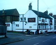
Coton in the Elms has 2 pubs. The Black Horse was refurbished in 2009. The Queen's Head Inn dates back to the 17th century and is currently an Indian Restaurant. Part of the premises was once a shop. Another pub, the Shoulder of Mutton, closed in 2010 and is currently being converted to a house.
in Lincolnshire; White Sands between Neston in Cheshire
and Flint, Flintshire
in Wales; and Westbury-on-Severn
Gloucestershire, all of which are 113 kilometres (70.2 mi) away.
at Cromwell Lock
, north of Newark-on-Trent
, in Nottinghamshire, 72 kilometres (44.7 mi) away.
Civil parish
In England, a civil parish is a territorial designation and, where they are found, the lowest tier of local government below districts and counties...
in the English
England
England is a country that is part of the United Kingdom. It shares land borders with Scotland to the north and Wales to the west; the Irish Sea is to the north west, the Celtic Sea to the south west, with the North Sea to the east and the English Channel to the south separating it from continental...
county of Derbyshire
Derbyshire
Derbyshire is a county in the East Midlands of England. A substantial portion of the Peak District National Park lies within Derbyshire. The northern part of Derbyshire overlaps with the Pennines, a famous chain of hills and mountains. The county contains within its boundary of approx...
. It is located five miles south of Burton upon Trent
Burton upon Trent
Burton upon Trent, also known as Burton-on-Trent or simply Burton, is a town straddling the River Trent in the east of Staffordshire, England. Its associated adjective is "Burtonian"....
.
South east of the village is Church Flatts Farm, which is defined by the Ordnance Survey
Ordnance Survey
Ordnance Survey , an executive agency and non-ministerial government department of the Government of the United Kingdom, is the national mapping agency for Great Britain, producing maps of Great Britain , and one of the world's largest producers of maps.The name reflects its creation together with...
as the farthest point from the sea in Great Britain.
History
Coton in the Elms is mentioned in the Domesday book
Domesday Book
Domesday Book , now held at The National Archives, Kew, Richmond upon Thames in South West London, is the record of the great survey of much of England and parts of Wales completed in 1086...
where it is then spelt Cotes. The book says under the title of “The lands of the Abbey of Burton
Burton-on-Trent Abbey
Burton Abbey at Burton upon Trent in Staffordshire, England, was originally founded in the 7th or 9th century by St Modwen or Modwenna; and later refounded in 1003 as a Benedictine abbey by Wulfric Spott, a thegn possibly descended from King Alfred...
".The Abbey of Burton held a considerable number of manors including several in Derbyshire given to it by the King. These included Coton in the Elms, Stapenhill
Stapenhill
Stapenhill is an area and civil parish in Burton upon Trent, Staffordshire in the UK. Stapenhill was a small village owned by Nigel of Stafford in 1086.The village of Stapenhill has long since been surrounded by new housing developments....
, Caldwell
Caldwell
- People with the surname Caldwell :* Alexander Caldwell, American politician* Alfred Caldwell, American landscape architect* Andre Caldwell, American football player* Anne Caldwell, American librettist* Ben Caldwell, cartoonist...
, Mickleover
Mickleover
Mickleover is a suburb located two miles west of the city centre and is the most westerly suburb of the City of Derby in the United Kingdom.-History:...
and Appleby Magna
Appleby Magna
Appleby Magna is a village and civil parish in the district of North West Leicestershire, England.The civil parish, as well as Appleby Magna, includes the small Hamlet of Appleby Parva and the Villages of Norton-Juxta-Twycross, Snarestone and Swepstone...
.
"In Coton in the Elms Ælfgar had two carucates of land to the geld. There is land for three ploughs. Now the abbot has it of the king. There are now one plough in demesneDemesneIn the feudal system the demesne was all the land, not necessarily all contiguous to the manor house, which was retained by a lord of the manor for his own use and support, under his own management, as distinguished from land sub-enfeoffed by him to others as sub-tenants...
and six villans and three bordars having two ploughs. TRE worth 40 shillings now 30 shillings."TRE is a LatinLatinLatin is an Italic language originally spoken in Latium and Ancient Rome. It, along with most European languages, is a descendant of the ancient Proto-Indo-European language. Although it is considered a dead language, a number of scholars and members of the Christian clergy speak it fluently, and...
ate acronym for Tempore Regis Edwardi, meaning 'in the time of King EdwardEdward the ConfessorEdward the Confessor also known as St. Edward the Confessor , son of Æthelred the Unready and Emma of Normandy, was one of the last Anglo-Saxon kings of England and is usually regarded as the last king of the House of Wessex, ruling from 1042 to 1066....
' (before the Battle of HastingsBattle of HastingsThe Battle of Hastings occurred on 14 October 1066 during the Norman conquest of England, between the Norman-French army of Duke William II of Normandy and the English army under King Harold II...
).
Coton is situated on the Walton Way and is first mentioned in 942 in a charter giving land in the area to Wulfrige the Black. This formed part of a much larger estate covering many of the villages in the area. Coton would seem to have been roughly in the centre of this estate. It would appear that it was a crossroads as there is an old lane which runs all the way from Tamworth
Tamworth
Tamworth is a town and local government district in Staffordshire, England, located north-east of Birmingham city centre and north-west of London. The town takes its name from the River Tame, which flows through the town, as does the River Anker...
through Coton and on northwards towards Burton on Trent. At the time of Domesday Burton Abbey held land at Coton - however this had been initially seized by King William - no doubt in part due to the rebellion led by Earl Morcar. However, by the time of Domesday this land had been restored to Burton. The village itself forms a diamond of roads around a small village green. The original route of the Walton Way may have been the south west corner of this diamond as this runs past the Church and Church Farm. To the north east of the village coal mining became important and this is reflected in the lane name Coalpit Lane.
The present church of St Mary was built in 1844-7 by Henry Isaac Stevens
Henry Isaac Stevens
Henry Isaac Stevens was an architect based in Derby. He was born in London, in 1806, and died in 1873. In the late 1850s he changed his name to Isaac Henry Stevens.-Family:His parents were Isaac Stevens and Elizabeth Young....
but not on the site of the original church, which was behind the Shoulder of Mutton pub. It has a narrow west tower with a recessed spire. It is generally believed that when the original church fell into disrepair, the bells were taken to the neighbouring Lullington
Lullington, Derbyshire
Lullington is a village and parish in south Derbyshire. It has an All Saints Church, a village hall, and a pub - The Colvile Arms...
village, so the inhabitants of Coton can still hear the old bells when the wind is in the right direction.
There is a Methodist chapel, built in 1922 to replace a smaller building in Chapel Street. The old building became known as the band room, where for many years a good band was run by a Mr Coates, who was also the village post master. It has also been used as a village hall.
The main occupations of the village inhabitants in the past has been mining and farming, though the pits are now all closed. For many of today's population (782 in 1991) it is a commuter base for the larger towns such as Burton-on-Trent, Swadlincote
Swadlincote
Swadlincote is a town and unparished area in South Derbyshire, about southeast of Burton-upon-Trent and about south of Derby. It is the main town of South Derbyshire and the seat of South Derbyshire District Council....
and Tamworth
Tamworth
Tamworth is a town and local government district in Staffordshire, England, located north-east of Birmingham city centre and north-west of London. The town takes its name from the River Tame, which flows through the town, as does the River Anker...
.
Coton in the Elms has 2 pubs. The Black Horse was refurbished in 2009. The Queen's Head Inn dates back to the 17th century and is currently an Indian Restaurant. Part of the premises was once a shop. Another pub, the Shoulder of Mutton, closed in 2010 and is currently being converted to a house.
Distance from coast
South east of the village – at – is Church Flatts Farm, which is defined by the Ordnance Survey as the farthest point from the sea ( at the mean low water line) in Great Britain. The location is Latitude: 52° 43.6' N Longitude: 1° 37.2' W. Coton is, by definition equidistant from Fosdyke WashFosdyke
Fosdyke is a village and civil parish in Lincolnshire, England. It lies about south of Boston just off the A17, and east from the junction of the A17 with the A16. The village is near the mouth of the River Welland, and the parish extends across the river to include both ends of the hamlet of...
in Lincolnshire; White Sands between Neston in Cheshire
Cheshire
Cheshire is a ceremonial county in North West England. Cheshire's county town is the city of Chester, although its largest town is Warrington. Other major towns include Widnes, Congleton, Crewe, Ellesmere Port, Runcorn, Macclesfield, Winsford, Northwich, and Wilmslow...
and Flint, Flintshire
Flint, Flintshire
Flint is a town in Flintshire, North Wales, lying on the estuary of the River Dee. It was the county town of the historic county of Flintshire and today is the third largest town in Flintshire. According to the 2001 Census the population of the community of Flint was 12,804...
in Wales; and Westbury-on-Severn
Westbury-on-Severn
Westbury-on-Severn is a rural village in England that is the centre of the large, rural parish, also called Westbury-on-Severn.-Location:The village is situated on the A48 road and bounded by the River Severn to the south and west.The village has a large parish church which is distinctive as the...
Gloucestershire, all of which are 113 kilometres (70.2 mi) away.
Distance from highest tidal water
The nearest high tide point is on the River TrentRiver Trent
The River Trent is one of the major rivers of England. Its source is in Staffordshire on the southern edge of Biddulph Moor. It flows through the Midlands until it joins the River Ouse at Trent Falls to form the Humber Estuary, which empties into the North Sea below Hull and Immingham.The Trent...
at Cromwell Lock
Cromwell Lock
Cromwell Lock is a large navigation lock on the River Trent in Nottinghamshire, and marks the tidal limit of the river. The first lock to be built on the site was constructed by the Trent Navigation Company, having been authorised by an Act of Parliament obtained in 1906. Construction began in late...
, north of Newark-on-Trent
Newark-on-Trent
Newark-on-Trent is a market town in Nottinghamshire in the East Midlands region of England. It stands on the River Trent, the A1 , and the East Coast Main Line railway. The origins of the town are possibly Roman as it lies on an important Roman road, the Fosse Way...
, in Nottinghamshire, 72 kilometres (44.7 mi) away.
Notable residents
- Nigel SimsNigel SimsDavid Nigel Sims , known as Nigel Sims, is an English former footballer who played as a goalkeeper in the Football League for Wolverhampton Wanderers, Aston Villa and Peterborough United in the 1950s and 1960s....
, goalkeeper for Wolverhampton Wanderers, Aston Villa and 'England B'.
See also
- Centre points of the United KingdomCentre points of the United KingdomThere has long been debate over the exact location of the geographical centre of the United Kingdom, and its constituent countries, due to the complexity and method of the calculation, such as whether to include offshore islands, and the fact that erosion will cause the position to change over time...
- Coastline of the United Kingdom
- Fenny DraytonFenny DraytonFenny Drayton is a village in Leicestershire England, in the district of Hinckley and Bosworth. Near to the county border of Warwickshire and using a Warwickshire County postcode, it is just off the A444 road an old Roman road, north of Nuneaton close to its crossroads with the A5...
- Centre of England, 24 kilometres (14.9 mi) south.