
Appleby Magna
Encyclopedia
North West Leicestershire
North West Leicestershire is a local government district in Leicestershire, England. Its main towns are Ashby-de-la-Zouch and Coalville.The district contains East Midlands Airport, which operates flights to the rest of Britain and to various places in Europe...
, England
England
England is a country that is part of the United Kingdom. It shares land borders with Scotland to the north and Wales to the west; the Irish Sea is to the north west, the Celtic Sea to the south west, with the North Sea to the east and the English Channel to the south separating it from continental...
.
The civil parish, as well as Appleby Magna, includes the small Hamlet of Appleby Parva
Appleby Parva
Appleby Parva, or Little Appleby , part of the parish of Appleby Magna in Leicestershire, is a hamlet about a mile south of Appleby church at the crossroads of the highways from Ashby de la Zouch to Tamworth and from Atherstone to Burton upon Trent.The village was also calculated to be the centre...
and the Villages of Norton-Juxta-Twycross, Snarestone
Snarestone
Snarestone is a small rural village in North West Leicestershire, England.It lies on the edge of the National Forest and is from the market town of Ashby-de-la-Zouch. It has a population of approximately 300 people and 120 households....
and Swepstone
Swepstone
Swepstone is a village and civil parish in the North West Leicestershire district of Leicestershire, England, about five miles south of Ashby de la Zouch. The parish includes the villages of Swepstone and Newton Burgoland....
. Historically Appleby was one of the largest and wealthiest Parishes in Leicestershire, which the size of church is testament to.
The original name Aeppel-by refers to apple trees, the by suggesting a Danish settlement. The village lies on the edge of the ancient boundary between the Kingdoms Mercia
Mercia
Mercia was one of the kingdoms of the Anglo-Saxon Heptarchy. It was centred on the valley of the River Trent and its tributaries in the region now known as the English Midlands...
and the Danelaw
Danelaw
The Danelaw, as recorded in the Anglo-Saxon Chronicle , is a historical name given to the part of England in which the laws of the "Danes" held sway and dominated those of the Anglo-Saxons. It is contrasted with "West Saxon law" and "Mercian law". The term has been extended by modern historians to...
.
The village sits on the outskirts of The National Forest
National Forest, England
The National Forest is one of England’s most ambitious environmental projects. Across parts of Leicestershire, Derbyshire and Staffordshire, are being transformed, blending ancient woodland with new planting to create a new national forest...
and is bordered by the Historic Gopsall Park
Gopsall
Gopsall is an area of Crown Estate land in North West Leicestershire, England. It is located between the villages of Appleby Magna, Shackerstone, Twycross and Snarestone....
Estate.
The Ashby-De-La-Zouch Canal passes within a mile of the village, as do the M42
M42
M42 or M-42 may refer to:In science:* Messier 42, a nebula also called the Orion Nebula* the 42nd known Mersenne primeIn transportation:* M-42 , a state highway in Michigan...
and A444.
History
Pre-Historic TimesThere is evidence of Settlement in Appleby from the early Neolithic
Neolithic
The Neolithic Age, Era, or Period, or New Stone Age, was a period in the development of human technology, beginning about 9500 BC in some parts of the Middle East, and later in other parts of the world. It is traditionally considered as the last part of the Stone Age...
period, 6000 years ago. There was no one settlement, but a scattering of round houses, farming the land south of the River Mease
River Mease
The River Mease is a lowland clay river in the Midlands area of England. It flows through the counties of Leicestershire, Derbyshire and Staffordshire and forms the administrative border between these counties for parts of its length....
. Crop markings reviled the oval ditch of a 6 acre enclosure in the same area. An archaeological dig in 1966 uncovered Pre-Historic pottery.
A short distance to the East, near the White House Farm, crop marks revealed a rectangular enclosure, reported to be an Iron Age
Iron Age
The Iron Age is the archaeological period generally occurring after the Bronze Age, marked by the prevalent use of iron. The early period of the age is characterized by the widespread use of iron or steel. The adoption of such material coincided with other changes in society, including differing...
site. To the east of the parish, on Birdshill Gorse, a further ring ditch was discovered, which it is suggested is Bronze Age
Bronze Age
The Bronze Age is a period characterized by the use of copper and its alloy bronze as the chief hard materials in the manufacture of some implements and weapons. Chronologically, it stands between the Stone Age and Iron Age...
.
Roman Era
There is limited evidence of activity during the Roman Period. Appleby is situated near to 3 known Roman roads: Watling Street
Watling Street
Watling Street is the name given to an ancient trackway in England and Wales that was first used by the Britons mainly between the modern cities of Canterbury and St Albans. The Romans later paved the route, part of which is identified on the Antonine Itinerary as Iter III: "Item a Londinio ad...
, which passes 10 miles south of the village, Bath Lane, which passes 5 miles north of the village and Salt Street, which forms the Parish's south boundary as well as part of the county boundary between Leicestershire
Leicestershire
Leicestershire is a landlocked county in the English Midlands. It takes its name from the heavily populated City of Leicester, traditionally its administrative centre, although the City of Leicester unitary authority is today administered separately from the rest of Leicestershire...
and Warwickshire
Warwickshire
Warwickshire is a landlocked non-metropolitan county in the West Midlands region of England. The county town is Warwick, although the largest town is Nuneaton. The county is famous for being the birthplace of William Shakespeare...
. It is suggested a Roman road ran through the Parish, due to the name of the neighbouring village Stretton-En-Le-Field, but this has not been confirmed.
During construction of a hotel in Appleby Fields, next to Junction 11 of the M42, evidence was found of a British-Romano farm dating from the 4th century. Roman coins from the reigns of Constantine I
Constantine I
Constantine the Great , also known as Constantine I or Saint Constantine, was Roman Emperor from 306 to 337. Well known for being the first Roman emperor to convert to Christianity, Constantine and co-Emperor Licinius issued the Edict of Milan in 313, which proclaimed religious tolerance of all...
(307-337) and Magnentius
Magnentius
Flavius Magnus Magnentius was a usurper of the Roman Empire .-Early life and career:...
(350-353) along with pottery fragments dating from the late 4th century. Evidence was found of Corn drying ovens and 3 farm buildings. Other finds included: roof tiles, a corroded knife blade, copper pins, an iron hobnail and fragments of quern stones. Animal bones were found showing that cattle, sheep, pigs, cats and dogs we're kept on the farm.
Roman coins we're also found in the grounds of Appleby Hall.
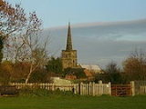
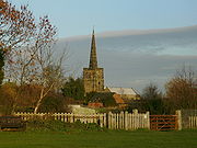
It has also been suggested that the site of Saint Michael's and All Angels church was the site of a Roman temple.
The Saxon Era
The village was situated in the Saxon Kingdom of Mercia, and is only 8 miles from its capital; Tamworth
Tamworth
Tamworth is a town and local government district in Staffordshire, England, located north-east of Birmingham city centre and north-west of London. The town takes its name from the River Tame, which flows through the town, as does the River Anker...
. The settlement of Appleby Magna grew around the Meadow Brook in the Saxon Period. It was during this time that the first Christian church was built on the site of Saint Michael's and All Angels Church. It was a wooden chapel, constructed on the site of the Saint Helen's Chapel in the Church.
The village is centred on the narrowest part of the shallow valley surrounding the Meadow Brook. The Manor House (The Moat House) and Church were built on opposite sides of the brook and the village grew up around them.
After the Norman Invasion
Appleby Magna was mentioned as Apleby in the Domesday book
Domesday Book
Domesday Book , now held at The National Archives, Kew, Richmond upon Thames in South West London, is the record of the great survey of much of England and parts of Wales completed in 1086...
, when it was part of both Derbyshire
Derbyshire
Derbyshire is a county in the East Midlands of England. A substantial portion of the Peak District National Park lies within Derbyshire. The northern part of Derbyshire overlaps with the Pennines, a famous chain of hills and mountains. The county contains within its boundary of approx...
and Leicestershire
Leicestershire
Leicestershire is a landlocked county in the English Midlands. It takes its name from the heavily populated City of Leicester, traditionally its administrative centre, although the City of Leicester unitary authority is today administered separately from the rest of Leicestershire...
. It belonged to the Abbey of Burton
Burton-on-Trent Abbey
Burton Abbey at Burton upon Trent in Staffordshire, England, was originally founded in the 7th or 9th century by St Modwen or Modwenna; and later refounded in 1003 as a Benedictine abbey by Wulfric Spott, a thegn possibly descended from King Alfred...
, Henry de Ferrers and Lady Godiva
Lady Godiva
Godiva , often referred to as Lady Godiva , was an Anglo-Saxon noblewoman who, according to legend, rode naked through the streets of Coventry in order to gain a remission of the oppressive taxation imposed by her husband on his tenants...
, of Coventry. The village was worth Ninety shillings.
There are records of a rector at Appleby from at least 1207 . The site of this early church is on the site of Saint Helen's Chapel in the current church and at the time of doomsday was described as:
‘a small building capable of holding only two or three dozen people. There were no side aisles, only a small box-like nave with a small chancel to the east ... There were no seats for the public, who would have had to stand throughout the services, though there may have been benches against the wall for the infirm.... The altar was at the east end of the nave or just inside the chancel. In the case of the nave altar, the priest probably stood under the chancel arch and celebrated the mass facing the people. If the altar was just east of the chancel arch, the priest may still have celebrated westward from a position in the middle of the chancel’
Late Middle Ages
Saint Helen's Chapel is the earliest surviving building in the Village. It dates from the early 14th century, but its exact date of construction is unknown. It was used as a private chapel for the De Appleby Family, Lords of the Manor of Appleby who resided in the adjacent Manor House (The Moat House). The De Appleby Family were Lords of the manor from the early 12th century until the 16th century.
The chapel was built on the site of the earlier religious buildings and the site was already used as a burial site.
The church was enlarged to its present size in the early 14th century and was named Saint Michael's and All Angels. Saint Helen's Chapel was incorporated into the North East section of the church and served as both a private chapel and burial site for the De Appleby family. Most of the tombs have been removed but the Alabaster effigies of Sir Edmund De Appleby and his wife Joan, dating from 1375, still survives. The chapel would eventually become known as the De Appleby Chapel although is currently used as the church vestry.
The earliest currently surviving fragments of the Manor House (The Moat House), date from Sir Edmund's time when the Manor was enlarged into a large, moated, fortified, courtyard house.
A rectory which stood opposite the church (on the site of the current Almshouses), a tithe barn which stood on the eastern wall of the churchyard and two water mills, one by the moat house and one at Mease-Meadow we're all constructed in the same era, although non survive.
Tudor and Jacobean Period
It was during the Tudor Era that the downfall of the De Appleby family occurred.
Sir George De Appleby, was killed following the Battle of Pinkie Cleugh
Battle of Pinkie Cleugh
The Battle of Pinkie Cleugh, on the banks of the River Esk near Musselburgh, Scotland on 10 September 1547, was part of the War of the Rough Wooing. It was the last pitched battle between Scottish and English armies, and is seen as the first modern battle in the British Isles...
. His wife, Joyce, was burned as a Protestant Martyr in Lichfield
Lichfield
Lichfield is a cathedral city, civil parish and district in Staffordshire, England. One of eight civil parishes with city status in England, Lichfield is situated roughly north of Birmingham...
. Their eldest son, George, sold the Manor in 1549 and later drowned. His nephew, Francis(son of his brother Richard), died childless, ending the male line of the De Appleby family.
It was at the end of the Tudor Period that the next influential family, The Moores, entered the village. Charles Moore is recorded as "Lord of the manor of Appleby Parva" in 1599 , although the exact date of his arrival to the village is unknown.
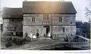
Charles' second son, Sir John Moore (Born 1620) is responsible for the village's most famous building, the Sir John Moore Church of England Primary School. As his elder brother, Charles, was expected to inherit the family estates, as second son, Sir John, was expected to make his own way in the world. Sir John, and all subsequent generations of younger sons, went to London to make a living as merchants. Sir John was unquestionably the most successful, becoming friends with Charles II, Lord Mayor and subsequently Alderman of London.
Sir John Moore died childless, but before his death, chose to use his money for the benefit of the children of his home parish, Appleby. Sir John commissioned Sir Christopher Wren
Christopher Wren
Sir Christopher Wren FRS is one of the most highly acclaimed English architects in history.He used to be accorded responsibility for rebuilding 51 churches in the City of London after the Great Fire in 1666, including his masterpiece, St. Paul's Cathedral, on Ludgate Hill, completed in 1710...
to design a school building to be built in Appleby Magna. The work was carried out by a Member of Wren's company, Sir William Wilson
William Wilson (architect)
Sir William Wilson was an English architect, builder and sculptor.Born in 1641 in Leicester, he was the son of a baker. In his early life, it is believed that he served an apprenticeship with a statuary mason. It is also claimed that he studied under Sir Christopher Wren at Oxford University where...
, and was completed in 1697; Sir John did not live to see its completion.
The Moore family held considerable influence in the village until the 20th century with members of the family being both Lord and Squire of the Manor, and Rector of Saint Michael's and all Angels Church.
Georgian and Victorian Times
The parish was enclosed in 1771 by Parliamentary Agreement after a series of piecemeal exchanges
The Sir John Moore Church of England School
Sir John Moore Church of England Primary School is a junior school situated in the village of Appleby Magna, in Leicestershire, England.The school building dates from 1697, based on an original design by Sir Christopher Wren, with financing from local land holder, Lord Mayor and Alderman of London,...
being the first of the family's constructions.
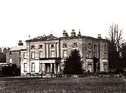
In 1770, the family demolished the old Manor at Appleby Parva and by 1790 had built "Appleby House", a large Georgian style house.
This was remodelled between 1832 and 1838 into a Classical styled mansion known as "Appleby Hall". Appleby House was retained as part of the new Hall, and large stables, outbuildings and lodges were built.
During the Moores time as Rector in Appleby Magna, the old rectory (opposite the church) was demolished and new Georgian rectory was built on the Northern fringe of the village. (The Rectory is currently up for sale )
The "Misses Moores" (Husbandless Sisters to the Squire) built the Almshouses in 1839, to save their elderly servants from having to go into the workhouse.
The village grew considerably during the Georgian and Victorian times. As well as many houses, buildings included: a new primary school (now the church hall), built in 1845, two baptist chapels built in 1820 and 1826, and several farms.
Before re-alignment of the county boundaries in 1897, the parish was spread across two counties, the antiquarian William Burton observing in 1622 that it was “upon the verie edge of the countie of Derby, with which it is so intermingled that the houses... cannot be distinguished which be of eyther shire”.
The 1801 national census records a total population of 935, evenly divided between the two counties. Appleby's 19th-century inhabitants were engaged in framework knitting and stocking manufacture. The village has 14 farms, with many more in the surrounding villages; Agricultural labouring was popular work in the 19th century. The village sits on the edge of the South Derbyshire Coalfields, and coal mining became an increasingly area of employment through until the mid 20th century.
The Moat House
Another famous resident of the Moat House was Joyce De Appleby. Joyce was created a Protestant Martyr after she was burnt at the stake by Bloody Mary (Queen Mary I of England) in Lichfield
Lichfield
Lichfield is a cathedral city, civil parish and district in Staffordshire, England. One of eight civil parishes with city status in England, Lichfield is situated roughly north of Birmingham...
Market Place, for not converting to Catholicism.
Joyce's husband, Sir George, was killed following the Battle of Pinkie Cleugh
Battle of Pinkie Cleugh
The Battle of Pinkie Cleugh, on the banks of the River Esk near Musselburgh, Scotland on 10 September 1547, was part of the War of the Rough Wooing. It was the last pitched battle between Scottish and English armies, and is seen as the first modern battle in the British Isles...
. Their eldest son, George, sold the Manor in 1549 and later drowned. His nephew, Francis(son of his brother Richard), died childless, ending the male line of the De Appleby family.
The original house was stone built, around a courtyard. Only the stone gatehouse survives from the original building. The timber-framed part of the building we see today was constructed during the 16th Century.
In the land in front of the house is an ancient stone dovecote
Dovecote
A dovecote or dovecot is a structure intended to house pigeons or doves. Dovecotes may be square or circular free-standing structures or built into the end of a house or barn. They generally contain pigeonholes for the birds to nest. Pigeons and doves were an important food source historically in...
. Enlarged when the house was built, the dovecote is believed to have Saxon origins. It probably belonged to the Saxon predecessor of the neighbouring church. The area is known to have been inhabited since Neolithic times with many Bronze Age tools having been found in various fields around the village.
The moat house had a succession of occupants after 1560. Edward Griffyn of Dingley
Dingley, Northamptonshire
Dingley is a village and civil parish in Northamptonshire, England, located along the A427, about east of the nearest town, Market Harborough. It is also close to the A6 and near the border with Leicestershire...
in Northamptonshire
Northamptonshire
Northamptonshire is a landlocked county in the English East Midlands, with a population of 629,676 as at the 2001 census. It has boundaries with the ceremonial counties of Warwickshire to the west, Leicestershire and Rutland to the north, Cambridgeshire to the east, Bedfordshire to the south-east,...
sold the property to Wolstan Dixie
Wolstan Dixie
Sir Wolstan Dixie, , was a merchant and administrator, and Lord Mayor of London in 1585.-Life:He was the son of Thomas Dixie and Anne Jephson, who lived at Catworth in Huntingdonshire. Wolstan was the fourth son of his father, and went into business...
of London through a series of legal processes, covenants, fines and recoveries from November 1598. The Dixies then granted the capital messuage and its attached lands to Market Bosworth Free School, who leased it to a succession of tenants for an initial yearly rent of £50 (£5,032 in today's money. Part of The Moat House – the original stone gatehouse – was already ancient when purchased by Sir Wolstan Dixie in 1599 for the trustees of the free school at Market Bosworth
Market Bosworth
Market Bosworth is a small market town and civil parish in Leicestershire, England. It formerly formed a district known as the Market Bosworth Rural District. In 1974 it merged with the Hinckley Rural District to form a new district named Hinckley and Bosworth...
.
In March 1619 the 'Mansion house' together with six yardlands and other appurtenances, five pasture closes, two crofts, a messuage or dwelling house, another two and a half yardlands and the water mill at Measham, was leased to Humphrey Francys of Barwell
Barwell
Barwell is a civil parish and large village in Leicestershire, England, with a population of around 8,750 people. The name literally translates as "Stream of the Boar" and is said to originate from a boar that used to drink from the well near a brook in Barwell. It was originally known as Borewell,...
, a yeoman, for three years.
Humphrey does not appear to have occupied the premises - or stayed long if he did - for in October 1621 there was another lease for three lives which was also terminated fairly abruptly when, in December 1628, yet another lease was drawn up. This time the 'Mannor Place or capital messuage of Appulbie the greate' was granted to Thomas and William Hartill of Stretton-en-le-field
Stretton en le Field
Stretton en le Field is a civil parish and hamlet in the North West Leicestershire district of Leicestershire, England. It is about seven miles south-west of Ashby de la Zouch, and according to the 2001 census the parish had a population of 36....
as "feoffees of the Grammar SchoolW. The lease stipulated that 'from time to time as the court shall appoynt’ they were required to ‘permit upon summons or warninges to the said court’ any of the lessors to enter the house and for them to 'mark and brand’ the edges of the ridges and baulkes in the common fields and other places 'with a great Roman S'. The tenants were not to 'lopp, topp shred…nor putt down' any oak, ash, elm or fruit trees, except for getting an annual allowance of timber for repairing the premises.
In October 1649 another lease drawn up for eighty years reinforced these rights, inserting provision for the lessees, Dixie, Farmer and Saunders.
The tenants were thereby given an opportunity to obtain coal for fuel, stones for repairing the old gatehouse and plaster for the walls. From time to time the old moat house may have been left unoccupied. In the 1663 constables’ returns for the hearth tax assessment, for example, it is recorded as an ‘empty house’ with six hearths in the possession of John Stanton.
The reference to Richard Saunders is curious as in December 1711 he is referred to as a ‘lunatic’, an agreement having been drawn up to cover his rights and interests as a result of this and other leases made to him in his infancy.
The moat house continued to be let to a succession of farming tenants over the course of the 18th century. In June 1715 the ‘Manor House’ with all lands appertaining and 'three water grist mills' with fishing rights were leased to Mathew White of Great Appleby. In 1753 the land and water mills were given to William Cooper. A few years later in April 1753 an agreement was drawn up leasing the lands to Joseph Wilkes
Joseph Wilkes
Joseph Wilkes was an 18th-century English industrialist and agricultural improver born in the village of Overseal in Derbyshire but more commonly associated with the village of Measham in Leicestershire....
of Overseal
Overseal
Overseal is a village situated 3 miles south of Swadlincote, in South Derbyshire. It is sometimes locally pronounced as "Ovversale" and is the southernmost settlement in Derbyshire, on the border with Leicestershire.-Geography:...
. By the early 19th century the lands were being let on a yearly tenancy first to the Wilkes, then Thomas Heafield and Thomas Taverner, local yeoman farmers, a further indication perhaps that the house itself may have been left unoccupied.
The house was occupied by the Gothard family for much of the 19th century before being finally sold in the 1960s, by which time many of the outbuildings the kitchens had fallen into a state of disrepair and had to be demolished. Much of the surrounding land was also sold off at this point. In 1935 an American had tried to purchase the house and have it shipped abroad.
Dormers Hall
In the field behind the Church Hall are strange and for a long time, unexplained, earthworks. There is a large excavation, long since grassed over, with a pond near its furthest point and either side of this, to north and south, the field has ridges and ditches of different sizes and orientations, some of them overlying or cutting across others and all of them now grassed over in the pasture.The north-west quarter of the field (towards the modern Rectory) shows ridge-and-furrow strips (i.e. ‘lands’ or ‘londs’), running roughly north-south and these appear to be the oldest earthwork preserved in the pasture as the other disturbances cut across them. These ridge-and-furrow strips are a remnant of the medieval system of agriculture in which farming land was organised in open fields.
Dominating the northern half of the field are two unusually large ridges and ditches. Any hedges which grew on the banks must have been removed and the ridges and ditches returned to pasture without being levelled. But a hawthorn bush, possibly a hedgerow remnant, survived on one of the long north-south banks until recently (1999). This system of larger banks and ditches appears to have formed a long enclosure with two squarer enclosures on each side. The size and shape of these suggest a road or carriageway flanked by four small roughly rectangular paddocks. This road lead from Rectory lane to Dormers Hall which sat behind the church hall.
Little is know about the Hall, except that it was home to the Dormer family in the 16th century. The Hall was demolished at the end of the 16th century. Bricks from the hall can still be found under the grass in various parts of the field. A dovecote from the Hall survived until recently.
The excavated area with the pond cuts into the earlier earthworks. This is the type of hollow left by clay extraction for brick-making. Other banks, ditches and irregular earthworks on the southern half of the modern field, towards Bowleys Lane, may include fish ponds. Church Street Farm house and buildings, the National School (now the Church Hall) and the new burial ground clearly have been taken from the original field at a late stage. None of their boundaries conforms to earlier alignments.
Sir John Moore School
The Sir John Moore Church of England Primary School was originally known as Appleby Grammar School. Built in 1697, the school was founded by Lord Mayor and Alderman of London, Sir John Moore, as a gift to his home village. The original plans for the school were drawn up by Sir Christopher WrenChristopher Wren
Sir Christopher Wren FRS is one of the most highly acclaimed English architects in history.He used to be accorded responsibility for rebuilding 51 churches in the City of London after the Great Fire in 1666, including his masterpiece, St. Paul's Cathedral, on Ludgate Hill, completed in 1710...
but the work was undertaken by Sir William Wilson
William Wilson (architect)
Sir William Wilson was an English architect, builder and sculptor.Born in 1641 in Leicester, he was the son of a baker. In his early life, it is believed that he served an apprenticeship with a statuary mason. It is also claimed that he studied under Sir Christopher Wren at Oxford University where...
, who had studied under Wren at Oxford University. The school recently had a multi-million pound restoration and now has a museum and computer suites as well as its own bar and other facilities. The Grade I listed building's main function is still that of the Church of England primary school.