

Climate of North Carolina
Encyclopedia
North Carolina
North Carolina is a state located in the southeastern United States. The state borders South Carolina and Georgia to the south, Tennessee to the west and Virginia to the north. North Carolina contains 100 counties. Its capital is Raleigh, and its largest city is Charlotte...
's climate varies from the Atlantic
Atlantic Ocean
The Atlantic Ocean is the second-largest of the world's oceanic divisions. With a total area of about , it covers approximately 20% of the Earth's surface and about 26% of its water surface area...
coast in the east to the Appalachian Mountain range in the west. The mountains often act as a "shield", blocking cold temperatures and storms from the Midwest from entering the Piedmont
Piedmont (United States)
The Piedmont is a plateau region located in the eastern United States between the Atlantic Coastal Plain and the main Appalachian Mountains, stretching from New Jersey in the north to central Alabama in the south. The Piedmont province is a physiographic province of the larger Appalachian division...
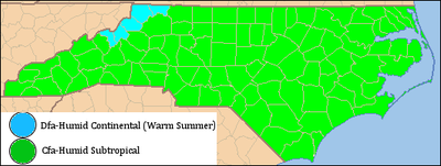
of North Carolina. Most of the state has a humid subtropical climate
Humid subtropical climate
A humid subtropical climate is a climate zone characterized by hot, humid summers and mild to cool winters...
(Koppen climate classification
Köppen climate classification
The Köppen climate classification is one of the most widely used climate classification systems. It was first published by Crimea German climatologist Wladimir Köppen in 1884, with several later modifications by Köppen himself, notably in 1918 and 1936...
Cfa), except in the higher elevations of the Appalachians which have a subtropical highland climate
Oceanic climate
An oceanic climate, also called marine west coast climate, maritime climate, Cascadian climate and British climate for Köppen climate classification Cfb and subtropical highland for Köppen Cfb or Cwb, is a type of climate typically found along the west coasts at the middle latitudes of some of the...
(Koppen Cfb). For most areas in the state, the temperatures in July during the daytime are around 90 °F (32.2 °C). In January the average temperatures range near 50 °F (10 °C).
Temperature
The temperature ranges of North Carolina vary with the state's geography. It is usually 20 °F (12 °C) warmer at eastern lower elevations than at the higher elevations in the west. In the winter, the temperature is fairly moderate in the central and eastern parts of North Carolina, due to the presence of the Appalachian mountains that divert cold weather currents originating in CanadaCanada
Canada is a North American country consisting of ten provinces and three territories. Located in the northern part of the continent, it extends from the Atlantic Ocean in the east to the Pacific Ocean in the west, and northward into the Arctic Ocean...
. Summers are warm and humid, with threats of hurricanes and tropical storms throughout the summer and early fall.
| Monthly Normal High and Low Temperatures (Fahrenheit) For Various North Carolina Cities | ||||||||||||
| City | Jan | Feb | Mar | Apr | May | Jun | Jul | Aug | Sep | Oct | Nov | Dec |
|---|---|---|---|---|---|---|---|---|---|---|---|---|
| Asheville Asheville, North Carolina Asheville is a city in and the county seat of Buncombe County, North Carolina, United States. It is the largest city in Western North Carolina, and the 11th largest city in North Carolina. The City is home to the United States National Climatic Data Center , which is the world's largest active... |
46/26 | 50/28 | 58/35 | 66/42 | 74/51 | 80/58 | 83/63 | 82/62 | 76/55 | 67/43 | 57/35 | 49/29 |
| Cape Hatteras | 54/39 | 55/39 | 60/44 | 68/52 | 75/60 | 82/68 | 85/73 | 85/72 | 81/68 | 73/59 | 65/50 | 57/43 |
| Charlotte Charlotte, North Carolina Charlotte is the largest city in the U.S. state of North Carolina and the seat of Mecklenburg County. In 2010, Charlotte's population according to the US Census Bureau was 731,424, making it the 17th largest city in the United States based on population. The Charlotte metropolitan area had a 2009... |
51/32 | 56/34 | 64/42 | 73/49 | 80/58 | 87/66 | 90/71 | 88/69 | 82/63 | 73/51 | 63/42 | 54/35 |
| Greensboro Greensboro, North Carolina Greensboro is a city in the U.S. state of North Carolina. It is the third-largest city by population in North Carolina and the largest city in Guilford County and the surrounding Piedmont Triad metropolitan region. According to the 2010 U.S... |
47/28 | 52/31 | 60/38 | 70/46 | 77/55 | 84/64 | 88/68 | 86/67 | 79/60 | 70/48 | 60/39 | 51/31 |
| Raleigh Raleigh, North Carolina Raleigh is the capital and the second largest city in the state of North Carolina as well as the seat of Wake County. Raleigh is known as the "City of Oaks" for its many oak trees. According to the U.S. Census Bureau, the city's 2010 population was 403,892, over an area of , making Raleigh... |
50/30 | 54/32 | 62/39 | 72/46 | 79/55 | 86/64 | 89/68 | 87/67 | 81/61 | 72/48 | 62/40 | 53/33 |
| Wilmington Wilmington, North Carolina Wilmington is a port city in and is the county seat of New Hanover County, North Carolina, United States. The population is 106,476 according to the 2010 Census, making it the eighth most populous city in the state of North Carolina... |
56/36 | 60/38 | 66/44 | 74/51 | 81/60 | 86/68 | 90/72 | 88/71 | 84/66 | 76/54 | 68/45 | 60/38 |
| ' | ||||||||||||
Precipitation
There is an average of forty-five inches of rain a year (fifty in the mountains). July storms account for much of this precipitation. As much as 15% of the rainfall during the warm season in the Carolinas can be attributed to tropical cyclones. Mountains usually see some snow in the fall and winter. Moist winds from the southwest drop an average of 80 inches (2,032 mm) of precipitation on the western side of the mountains, while the northeast-facing slopes average less than half that amount.| Average Monthly Precipitation | |||||||||||||
| City | Jan | Feb | Mar | Apr | May | Jun | Jul | Aug | Sep | Oct | Nov | Dec | Total |
|---|---|---|---|---|---|---|---|---|---|---|---|---|---|
| Asheville Asheville, North Carolina Asheville is a city in and the county seat of Buncombe County, North Carolina, United States. It is the largest city in Western North Carolina, and the 11th largest city in North Carolina. The City is home to the United States National Climatic Data Center , which is the world's largest active... |
2.6 inches (66 mm) | 3.1 inches (78.7 mm) | 4 inches (101.6 mm) | 3.3 inches (83.8 mm) | 2.9 inches (73.7 mm) | 3.5 inches (88.9 mm) | 3.4 inches (86.4 mm) | 4 inches (101.6 mm) | 3.1 inches (78.7 mm) | 2.7 inches (68.6 mm) | 2.6 inches (66 mm) | 2.7 inches (68.6 mm) | 38.1 inches (967.7 mm) |
| Cape Hatteras | 5.6 inches (142.2 mm) | 4.1 inches (104.1 mm) | 4.6 inches (116.8 mm) | 3.2 inches (81.3 mm) | 3.8 inches (96.5 mm) | 4.2 inches (106.7 mm) | 4.9 inches (124.5 mm) | 6.4 inches (162.6 mm) | 5.3 inches (134.6 mm) | 5.3 inches (134.6 mm) | 4.9 inches (124.5 mm) | 4.5 inches (114.3 mm) | 56.9 inches (1,445.3 mm) |
| Charlotte Charlotte, North Carolina Charlotte is the largest city in the U.S. state of North Carolina and the seat of Mecklenburg County. In 2010, Charlotte's population according to the US Census Bureau was 731,424, making it the 17th largest city in the United States based on population. The Charlotte metropolitan area had a 2009... |
3.7 inches (94 mm) | 3.7 inches (94 mm) | 4.6 inches (116.8 mm) | 3 inches (76.2 mm) | 3.6 inches (91.4 mm) | 3.5 inches (88.9 mm) | 3.8 inches (96.5 mm) | 4.1 inches (104.1 mm) | 3.3 inches (83.8 mm) | 3.2 inches (81.3 mm) | 3.1 inches (78.7 mm) | 3.3 inches (83.8 mm) | 43 inches (1,092.2 mm) |
| Greensboro Greensboro, North Carolina Greensboro is a city in the U.S. state of North Carolina. It is the third-largest city by population in North Carolina and the largest city in Guilford County and the surrounding Piedmont Triad metropolitan region. According to the 2010 U.S... |
3.3 inches (83.8 mm) | 3.3 inches (83.8 mm) | 3.8 inches (96.5 mm) | 3.2 inches (81.3 mm) | 3.6 inches (91.4 mm) | 3.8 inches (96.5 mm) | 4.4 inches (111.8 mm) | 4.1 inches (104.1 mm) | 3.3 inches (83.8 mm) | 3.4 inches (86.4 mm) | 2.9 inches (73.7 mm) | 3.2 inches (81.3 mm) | 42.3 inches (1,074.4 mm) |
| Raleigh Raleigh, North Carolina Raleigh is the capital and the second largest city in the state of North Carolina as well as the seat of Wake County. Raleigh is known as the "City of Oaks" for its many oak trees. According to the U.S. Census Bureau, the city's 2010 population was 403,892, over an area of , making Raleigh... |
3.5 inches (88.9 mm) | 3.5 inches (88.9 mm) | 3.7 inches (94 mm) | 2.8 inches (71.1 mm) | 3.8 inches (96.5 mm) | 3.6 inches (91.4 mm) | 4.4 inches (111.8 mm) | 4.4 inches (111.8 mm) | 3.1 inches (78.7 mm) | 3 inches (76.2 mm) | 2.9 inches (73.7 mm) | 3.1 inches (78.7 mm) | 41.8 inches (1,061.7 mm) |
| Wilmington Wilmington, North Carolina Wilmington is a port city in and is the county seat of New Hanover County, North Carolina, United States. The population is 106,476 according to the 2010 Census, making it the eighth most populous city in the state of North Carolina... |
3.6 inches (91.4 mm) | 3.5 inches (88.9 mm) | 4.3 inches (109.2 mm) | 2.9 inches (73.7 mm) | 4.3 inches (109.2 mm) | 5.4 inches (137.2 mm) | 7.9 inches (200.7 mm) | 7 inches (177.8 mm) | 5.6 inches (142.2 mm) | 3.3 inches (83.8 mm) | 3.3 inches (83.8 mm) | 3.5 inches (88.9 mm) | 55 inches (1,397 mm) |
Snow
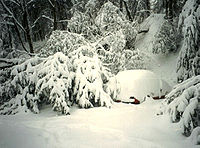
Snow
Snow is a form of precipitation within the Earth's atmosphere in the form of crystalline water ice, consisting of a multitude of snowflakes that fall from clouds. Since snow is composed of small ice particles, it is a granular material. It has an open and therefore soft structure, unless packed by...
in North Carolina is seen on a regular basis in the mountains. North Carolina averages 5 inches (127 mm) of snow a year. However, this also varies greatly across the state. Along the coast, most areas register less than 2 inches (50.8 mm) per year while the state capitol, Raleigh averages 7.5 inches (190.5 mm). Farther west in the Piedmont-Triad the average grows to around 9 inches (228.6 mm). The Charlotte area averages around 6.5 inches (165.1 mm). Again, the mountains in the west act as barrier preventing most snow storms from entering the Piedmont
Piedmont (United States)
The Piedmont is a plateau region located in the eastern United States between the Atlantic Coastal Plain and the main Appalachian Mountains, stretching from New Jersey in the north to central Alabama in the south. The Piedmont province is a physiographic province of the larger Appalachian division...
of North Carolina. When snow does make it past the mountains, it is usually light and is seldom on the ground for more than two or three days.
Canada
Canada is a North American country consisting of ten provinces and three territories. Located in the northern part of the continent, it extends from the Atlantic Ocean in the east to the Pacific Ocean in the west, and northward into the Arctic Ocean...
to Central America
Central America
Central America is the central geographic region of the Americas. It is the southernmost, isthmian portion of the North American continent, which connects with South America on the southeast. When considered part of the unified continental model, it is considered a subcontinent...
, brought a significant amount of snow to North Carolina. Newfound Gap
Newfound Gap
Newfound Gap is a mountain pass located near the center of the Great Smoky Mountains National Park of the southern Appalachian Mountains in the United States of America. Situated along the border of Tennessee and North Carolina, the state line crosses the gap, as does U.S...
received more than 36 inch (0.9144 m) of snow with drifts more than 5 feet (1.5 m) while Mount Mitchell
Mount Mitchell
Mount Mitchell can refer to:* Mount Mitchell, the highest point in the eastern United States* Mount Mitchell , in Jasper National Park of Canada* Mount Mitchell * Mount Mitchell , in Queensland...
measured over 4 feet (1.2 m) of snow with drifts to 14 feet (4.3 m). Most of the northwestern part of the state, received somewhere between 2 foot (0.6096 m) an 3 foot (0.9144 m) of snow.
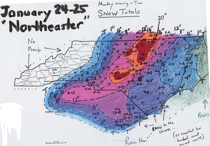
Another significant snowfall hit the Raleigh area in January 2000 when more than 20 inches (508 mm) of snow fell. There was also a heavy snowfall totaling 18 inches (457.2 mm) that hit the Wilmington just before Christmas in 1989, with little snow measured west of I-95
Interstate 95 in North Carolina
Interstate 95 is a major Interstate Highway, running along the East Coast of the United States from Florida to Maine. In North Carolina, I-95 runs diagonally across the eastern third of the state, from Rowland in the southwest to Roanoke Rapids in the northeast of the Inner Banks.-Route...
. Most of the big snows that impact areas east of the mountains come from extratropical cyclone
Extratropical cyclone
Extratropical cyclones, sometimes called mid-latitude cyclones or wave cyclones, are a group of cyclones defined as synoptic scale low pressure weather systems that occur in the middle latitudes of the Earth having neither tropical nor polar characteristics, and are connected with fronts and...
s which approach from the south across Georgia and South Carolina and move offshore the Carolinas. If the storms track too far east, the snow will be limited to the eastern part of the state. If the cyclone
Cyclone
In meteorology, a cyclone is an area of closed, circular fluid motion rotating in the same direction as the Earth. This is usually characterized by inward spiraling winds that rotate anticlockwise in the Northern Hemisphere and clockwise in the Southern Hemisphere of the Earth. Most large-scale...
s travel close to the coast, warm air will get pulled into eastern North Carolina due to increasing flow off the milder Atlantic ocean
Atlantic Ocean
The Atlantic Ocean is the second-largest of the world's oceanic divisions. With a total area of about , it covers approximately 20% of the Earth's surface and about 26% of its water surface area...
, bringing a rain/snow line well inland with heavy snow restricted to the piedmont. If the storm tracks inland into eastern North Carolina, the rain/snow line ranges between Raleigh and Greensboro.
| Average Monthly Snowfall | |||||||||||||
| City | Jan | Feb | Mar | Apr | May | Jun | Jul | Aug | Sep | Oct | Nov | Dec | Total |
|---|---|---|---|---|---|---|---|---|---|---|---|---|---|
| Asheville Asheville, North Carolina Asheville is a city in and the county seat of Buncombe County, North Carolina, United States. It is the largest city in Western North Carolina, and the 11th largest city in North Carolina. The City is home to the United States National Climatic Data Center , which is the world's largest active... |
4.6 inches (11.7 cm) | 4.6 inches (11.7 cm) | 3 inches (7.6 cm) | 0.7 inches (1.8 cm) | - | - | - | - | - | - | 0.7 inches (1.8 cm) | 2 inches (5.1 cm) | 15.6 inches (39.6 cm) |
| Cape Hatteras | 0.4 inches (1 cm) | 0.6 inches (1.5 cm) | 0.4 inches (1 cm) | - | - | - | - | - | - | - | - | 0.6 inches (1.5 cm) | 2 inches (5.1 cm) |
| Charlotte Charlotte, North Carolina Charlotte is the largest city in the U.S. state of North Carolina and the seat of Mecklenburg County. In 2010, Charlotte's population according to the US Census Bureau was 731,424, making it the 17th largest city in the United States based on population. The Charlotte metropolitan area had a 2009... |
2 inches (5.1 cm) | 1.7 inches (4.3 cm) | 1.2 inches (3 cm) | - | - | - | - | - | - | - | 0.1 inch (0.254 cm) | 0.5 inches (1.3 cm) | 5.5 inches (14 cm) |
| Greensboro Greensboro, North Carolina Greensboro is a city in the U.S. state of North Carolina. It is the third-largest city by population in North Carolina and the largest city in Guilford County and the surrounding Piedmont Triad metropolitan region. According to the 2010 U.S... |
3.1 inches (7.9 cm) | 2.5 inches (6.4 cm) | 1.7 inches (4.3 cm) | - | - | - | - | - | - | - | 0.1 inch (0.254 cm) | 1.2 inches (3 cm) | 8.6 inches (21.8 cm) |
| Raleigh Raleigh, North Carolina Raleigh is the capital and the second largest city in the state of North Carolina as well as the seat of Wake County. Raleigh is known as the "City of Oaks" for its many oak trees. According to the U.S. Census Bureau, the city's 2010 population was 403,892, over an area of , making Raleigh... |
2.2 inches (5.6 cm) | 2.6 inches (6.6 cm) | 1.3 inches (3.3 cm) | - | - | - | - | - | - | - | 0.1 inch (0.254 cm) | 0.8 inches (2 cm) | 7 inches (17.8 cm) |
| Wilmington Wilmington, North Carolina Wilmington is a port city in and is the county seat of New Hanover County, North Carolina, United States. The population is 106,476 according to the 2010 Census, making it the eighth most populous city in the state of North Carolina... |
0.4 inches (1 cm) | 0.5 inches (1.3 cm) | 0.4 inches (1 cm) | - | - | - | - | - | - | - | - | 0.6 inches (1.5 cm) | 1.9 inches (4.8 cm) |
Tropical cyclones

Located along the Atlantic Coast, North Carolina is no stranger to hurricanes. Many hurricanes that come up from the Caribbean Sea
Caribbean Sea
The Caribbean Sea is a sea of the Atlantic Ocean located in the tropics of the Western hemisphere. It is bounded by Mexico and Central America to the west and southwest, to the north by the Greater Antilles, and to the east by the Lesser Antilles....
make it up the coast of eastern America, passing by North Carolina.
Hurricane Hazel
Hurricane Hazel was the deadliest and costliest hurricane of the 1954 Atlantic hurricane season. The storm killed as many as 1,000 people in Haiti before striking the United States near the border between North and South Carolina, as a Category 4 hurricane...
struck North Carolina, at that time it was a category 4 hurricane within the Saffir-Simpson Hurricane Scale
Saffir-Simpson Hurricane Scale
The Saffir–Simpson Hurricane Scale , or the Saffir–Simpson Hurricane Wind Scale , classifies hurricanes — Western Hemisphere tropical cyclones that exceed the intensities of tropical depressions and tropical storms — into five categories distinguished by the intensities of their sustained winds...
. Hazel caused significant damage due to its strong winds. A weather station at Oak Island
Oak Island, North Carolina
Oak Island, North Carolina is a seaside town located mostly on the barrier island of Oak Island , in Brunswick County, North Carolina, United States. A small part of the town extends onto the mainland north of the island's bridge. The population was 6,571 at the 2000 census...
reported maximum sustained wind
Maximum sustained wind
The maximum sustained winds associated with a tropical cyclone are a common indicator of the intensity of the storm. Within a mature tropical cyclone, they are found within the eyewall at a distance defined as the radius of maximum wind, or RMW. Unlike gusts, the value of these winds are...
s of 140 miles per hour (225.3 km/h), while in Raleigh
Raleigh, North Carolina
Raleigh is the capital and the second largest city in the state of North Carolina as well as the seat of Wake County. Raleigh is known as the "City of Oaks" for its many oak trees. According to the U.S. Census Bureau, the city's 2010 population was 403,892, over an area of , making Raleigh...
winds of 90 miles per hour (144.8 km/h) were measured. After the hurricane passed, there were 19 deaths reported, as well as significant destruction. One person at Long Beach
Long Beach, North Carolina
Long Beach, North Carolina is a coastal neighborhood that is incorporated into Oak Island, North Carolina in the year of 1955. Located on Oak Island, it is well known for the total devastation it sustained during Hurricane Hazel in 1954; only five of the 357 buildings survived the storm...
claimed that "of the 357 buildings that existed at Long Beach, 352 were totally destroyed and the other five damaged". Hazel was described as "the most destructive storm in the history of North Carolina" in a 1989 report.
In 1996, Hurricane Fran
Hurricane Fran
Hurricane Fran was a powerful Cape Verde-type hurricane of the 1996 Atlantic hurricane season that made landfall near Cape Fear in North Carolina at Category 3 strength. Throughout the eastern United States, early statistics on Fran reported 27 deaths and $3.2 billion in damage...
made landfall in North Carolina. As a category 3 hurricane, Fran caused a great deal of damage, mainly through winds. Fran's maximum sustained wind speeds were 115 miles per hour (185.1 km/h), while North Carolina's coast saw surges of 8 feet (2.4 m) to 12 feet (3.7 m) above sea level. The amount of damage caused by Fran ranged from $1.275 to $2 billion dollars in North Carolina.
Rain
Heavy rains accompany tropical cyclones and their remnants which move northeast from the Gulf of MexicoGulf of Mexico
The Gulf of Mexico is a partially landlocked ocean basin largely surrounded by the North American continent and the island of Cuba. It is bounded on the northeast, north and northwest by the Gulf Coast of the United States, on the southwest and south by Mexico, and on the southeast by Cuba. In...
coastline, as well as inland from the western subtropical Atlantic ocean
Atlantic Ocean
The Atlantic Ocean is the second-largest of the world's oceanic divisions. With a total area of about , it covers approximately 20% of the Earth's surface and about 26% of its water surface area...
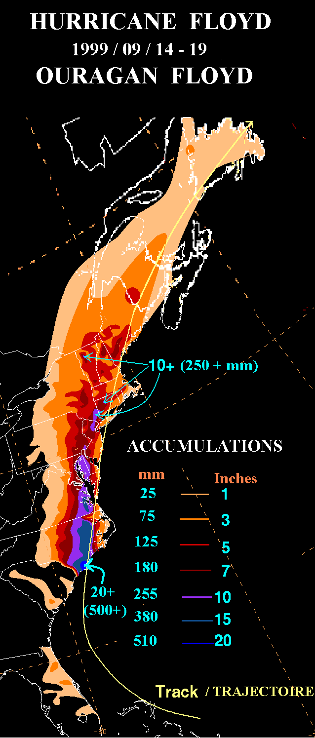
. Over the past 30 years, the wettest tropical cyclone to strike the coastal plain was Hurricane Floyd
Hurricane Floyd
Hurricane Floyd was the sixth named storm, fourth hurricane, and third major hurricane in the 1999 Atlantic hurricane season. Floyd triggered the third largest evacuation in US history when 2.6 million coastal residents of five states were ordered from their homes as it approached...
of September 1999, which dropped over 24 inches (609.6 mm) of rainfall north of Southport
Southport, North Carolina
Southport is a city in Brunswick County, North Carolina, near the mouth of the Cape Fear River. It is part of the Wilmington Metropolitan Statistical Area...
. Unlike Hazel and Fran, the main force of destruction was from precipitation. Prior to Hurricane Floyd reaching North Carolina, the state had already received large amounts of rain from Hurricane Dennis
Hurricane Dennis (1999)
Hurricane Dennis was an Atlantic hurricane that affected the Bahamas and parts of the Mid-Atlantic and Northeast during the 1999 Atlantic hurricane season. The fifth tropical cyclone, fourth tropical storm, and third hurricane of the season, Dennis originated from a tropical wave that passed north...
less than two weeks prior to Floyd. This saturated much of the Eastern North Carolina soil and allowed heavy rains from Hurricane Floyd to turn into floods. Over 35 people died from Floyd. In the mountains, Hurricane Frances
Hurricane Frances
Hurricane Frances was the sixth named storm, the fourth hurricane, and the third major hurricane of the 2004 Atlantic hurricane season. The system crossing the open Atlantic during mid to late August, moving to the north of the Lesser Antilles while strengthening. Its outer bands affected Puerto...
of September 2004 was nearly as wet, bringing over 23 inches (584.2 mm) of rainfall to Mount Mitchell
Mount Mitchell
Mount Mitchell can refer to:* Mount Mitchell, the highest point in the eastern United States* Mount Mitchell , in Jasper National Park of Canada* Mount Mitchell * Mount Mitchell , in Queensland...
.
Severe weather
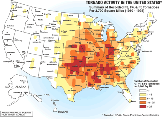
In most years, the greatest economic loss entailed in North Carolina is due to severe weather spawned by summer thunderstorms. These storms affect limited areas, with their hail and wind accounting for an average annual loss of over US$5 million. North Carolina is outside the main tornado development region of the United States known as tornado alleyTornado Alley
Tornado Alley is a colloquial and popular media term that most often refers to the area of the United States where tornadoes are most frequent. Although an official location is not defined, the area between the Rocky Mountains and Appalachian Mountains is usually associated with it.The areas...
, but still averages two to three per year. They occur mostly east of the Mountains during early spring.
Winter
In winter, North Carolina is protected by the Appalachian MountainsAppalachian Mountains
The Appalachian Mountains #Whether the stressed vowel is or ,#Whether the "ch" is pronounced as a fricative or an affricate , and#Whether the final vowel is the monophthong or the diphthong .), often called the Appalachians, are a system of mountains in eastern North America. The Appalachians...
on the western front. Cold fronts from Canada
Canada
Canada is a North American country consisting of ten provinces and three territories. Located in the northern part of the continent, it extends from the Atlantic Ocean in the east to the Pacific Ocean in the west, and northward into the Arctic Ocean...
and the Gulf of Mexico
Gulf of Mexico
The Gulf of Mexico is a partially landlocked ocean basin largely surrounded by the North American continent and the island of Cuba. It is bounded on the northeast, north and northwest by the Gulf Coast of the United States, on the southwest and south by Mexico, and on the southeast by Cuba. In...
rarely make it past the towering mountains. Cold winds do make it across the peaks once or twice a year and force the temperatures to drop to about 10 °F (-12.2 °C) in central North Carolina. Although temperates below zero degrees Fahrenheit are extremely rare outside of the mountains it has happened before. The coldest ever recorded temperature in North Carolina was -34 °F on January 21, 1985
January 1985 Arctic outbreak
The 1985 Arctic outbreak was a meteorological event, the result of the shifting of the polar vortex further south than is normally seen. Blocked from its normal movement, polar air from the north pushed into nearly every section of the eastern half of the United States and Canada, shattering record...
, at Mount Mitchell
Mount Mitchell
Mount Mitchell can refer to:* Mount Mitchell, the highest point in the eastern United States* Mount Mitchell , in Jasper National Park of Canada* Mount Mitchell * Mount Mitchell , in Queensland...
. The winter temperatures on the coast are mostly due to Atlantic Ocean and the Gulf Stream
Gulf Stream
The Gulf Stream, together with its northern extension towards Europe, the North Atlantic Drift, is a powerful, warm, and swift Atlantic ocean current that originates at the tip of Florida, and follows the eastern coastlines of the United States and Newfoundland before crossing the Atlantic Ocean...
, adjusting the temperature on a day-to-day basis. The average ocean temperature in Southport
Southport, North Carolina
Southport is a city in Brunswick County, North Carolina, near the mouth of the Cape Fear River. It is part of the Wilmington Metropolitan Statistical Area...
in January is still higher than the average ocean temperature in Maine during July. Snow is common in the mountains, although many ski resorts use snowmaking equipment to make sure there is always snow on their land. North Carolina's humidity is highest in the winter.
Spring
Tornadoes are most likely early in the spring. The month of May experiences the greatest rise in temperatures. During the spring, there are warm days and cool nights in the piedmont. Temperatures are somewhat cooler in the mountains, and warmer, particularly at night, near the coast. North Carolina's humidity is lowest in the Spring.Summer

Mount Mitchell
Mount Mitchell can refer to:* Mount Mitchell, the highest point in the eastern United States* Mount Mitchell , in Jasper National Park of Canada* Mount Mitchell * Mount Mitchell , in Queensland...
lying at 68 °F (20 °C). Morning temperatures are on average 20 °F (12 °C) colder than afternoon temperatures, except along the Atlantic Coast
East Coast of the United States
The East Coast of the United States, also known as the Eastern Seaboard, refers to the easternmost coastal states in the United States, which touch the Atlantic Ocean and stretch up to Canada. The term includes the U.S...
. The largest economic loss from severe weather in North Carolina is due to severe thunderstorms in the summer, although they usually only hit small areas. Tropical cyclones can impact the state during the summer as well. Fog
Fog
Fog is a collection of water droplets or ice crystals suspended in the air at or near the Earth's surface. While fog is a type of stratus cloud, the term "fog" is typically distinguished from the more generic term "cloud" in that fog is low-lying, and the moisture in the fog is often generated...
s are also frequent in the summer.
Fall
Fall is the most rapidly changing season temperature wise, especially in October and November. Tropical cyclones remain a threat until late in the season. The Appalachian MountainsAppalachian Mountains
The Appalachian Mountains #Whether the stressed vowel is or ,#Whether the "ch" is pronounced as a fricative or an affricate , and#Whether the final vowel is the monophthong or the diphthong .), often called the Appalachians, are a system of mountains in eastern North America. The Appalachians...
are visited a lot this time of year, due to the leaves changing color in the trees.
Effects
The water on North Carolina's shores have risen 2 inches (50.8 mm) but the reason is unknown. Temperatures in North Carolina have risen too. Over the last 100 years, the average temperature in Chapel Hill
Chapel Hill, North Carolina
Chapel Hill is a town in Orange County, North Carolina, United States and the home of the University of North Carolina at Chapel Hill and UNC Health Care...
has gone up 1.2 °F (0.7 °C) and precipitation in some parts of the state has increased by 5 percent.
See also
- ClimateClimateClimate encompasses the statistics of temperature, humidity, atmospheric pressure, wind, rainfall, atmospheric particle count and other meteorological elemental measurements in a given region over long periods...
- Climate changeClimate changeClimate change is a significant and lasting change in the statistical distribution of weather patterns over periods ranging from decades to millions of years. It may be a change in average weather conditions or the distribution of events around that average...
- ClimatologyClimatologyClimatology is the study of climate, scientifically defined as weather conditions averaged over a period of time, and is a branch of the atmospheric sciences...
- List of North Carolina hurricanes
- List of North Carolina weather records
- List of wettest known tropical cyclones in North Carolina
- MeteorologyMeteorologyMeteorology is the interdisciplinary scientific study of the atmosphere. Studies in the field stretch back millennia, though significant progress in meteorology did not occur until the 18th century. The 19th century saw breakthroughs occur after observing networks developed across several countries...