
Clay County, Kansas
Encyclopedia
Clay County is a county located in North Central Kansas
, in the Central
United States
. As of the 2010 census, the county population was 8,535. Its county seat
and most populous city is Clay Center
.
for all revenue and judicial purposes. Subsequently Clay was attached to Geary County
. In 1857, Clay was created and named in honor of the famous American statesman Henry Clay
, a member of the United States Senate
from Kentucky
and United States Secretary of State
in the 19th century.
In 1887, Atchison, Topeka and Santa Fe Railway
built a branch line from Neva (3 miles west of Strong City
) to Superior, Nebraska
. This branch line connected Strong City
, Neva, Rockland, Diamond Springs, Burdick
, Lost Springs
, Jacobs, Hope
, Navarre
, Enterprise
, Abilene
, Talmage
, Manchester
, Longford
, Oak Hill
, Miltonvale
, Aurora
, Huscher
, Concordia
, Kackley
, Courtland
, Webber
, Superior
. At some point, the line from Neva to Lost Springs
was pulled but the right of way has not been abandoned. This branch line was originally called "Strong City and Superior line" but later the name was shortened to the "Strong City line". In 1996, the Atchison, Topeka and Santa Fe Railway
merged with Burlington Northern Railroad
and renamed to the current BNSF Railway
. Most locals still refer to this railroad as the "Santa Fe".
(Phase II) was constructed north to south through Clay County, with much controversy over tax exemption and environmental concerns (if a leak ever occurs). A pumping station named Riley was built along the pipeline.
, county.
 As of the U.S. Census in 2000
, there were 8,822 people, 3,617 households, and 2,517 families residing in the county. The population density
was 14 people per square mile (5/km²). There were 4,084 housing units at an average density of 6 per square mile (2/km²). The racial makeup
of the county was 97.72% White
, 0.57% Black or African American
, 0.41% Native American
, 0.15% Asian
, 0.26% from other races, and 0.90% from two or more races
. Hispanic
or Latino
of any race were 0.83% of the population.
There were 3,617 household
s out of which 30.50% had children under the age of 18 living with them, 59.90% were married couples
living together, 6.10% had a female householder with no husband present, and 30.40% were non-families. 27.70% of all households were made up of individuals and 15.40% had someone living alone who was 65 years of age or older. The average household size was 2.39 and the average family size was 2.91.
In the county the population was spread out with 24.90% under the age of 18, 6.70% from 18 to 24, 23.90% from 25 to 44, 23.70% from 45 to 64, and 20.80% who were 65 years of age or older. The median age was 41 years. For every 100 females there were 99.10 males. For every 100 females age 18 and over, there were 95.60 males.
The median income for a household
in the county was $33,965, and the median income for a family was $41,103. Males had a median income of $28,817 versus $17,760 for females. The per capita income
for the county was $17,939. About 6.80% of families and 10.10% of the population were below the poverty line, including 14.60% of those under age 18 and 8.60% of those age 65 or over.
. The city of Clay Center
is considered governmentally independent and is excluded from the census figures for the townships. In the following table, the population center is the largest city (or cities) included in that township's population total, if it is of a significant size.
Additional information
Maps
Kansas
Kansas is a US state located in the Midwestern United States. It is named after the Kansas River which flows through it, which in turn was named after the Kansa Native American tribe, which inhabited the area. The tribe's name is often said to mean "people of the wind" or "people of the south...
, in the Central
Central United States
The Central United States is sometimes conceived as between the Eastern United States and Western United States as part of a three-region model, roughly coincident with the Midwestern United States plus the western and central portions of the Southern United States; the term is also sometimes used...
United States
United States
The United States of America is a federal constitutional republic comprising fifty states and a federal district...
. As of the 2010 census, the county population was 8,535. Its county seat
County seat
A county seat is an administrative center, or seat of government, for a county or civil parish. The term is primarily used in the United States....
and most populous city is Clay Center
Clay Center, Kansas
Clay Center is a city in and the county seat of Clay County, Kansas, United States. As of the 2010 census, the city population was 4,334.-Geography:Clay Center is located at...
.
19th century
When the first counties were created by the Kansas legislature in 1855, the territory within the present limits of the county was attached to Riley CountyRiley County, Kansas
Riley County is a county located in the U.S. state of Kansas. The county's population was 71,115 for the 2010 census. The largest city and county seat is Manhattan. The county is part of the Manhattan, Kansas, Metropolitan Statistical Area.Riley County is home to two of Kansas' largest...
for all revenue and judicial purposes. Subsequently Clay was attached to Geary County
Geary County, Kansas
Geary County is a county located in Northeast Kansas, in the Central United States. As of the 2010 census, the county population was 34,362. Its county seat and most populous city is Junction City. The county is named in honor of Governor John W. Geary...
. In 1857, Clay was created and named in honor of the famous American statesman Henry Clay
Henry Clay
Henry Clay, Sr. , was a lawyer, politician and skilled orator who represented Kentucky separately in both the Senate and in the House of Representatives...
, a member of the United States Senate
United States Senate
The United States Senate is the upper house of the bicameral legislature of the United States, and together with the United States House of Representatives comprises the United States Congress. The composition and powers of the Senate are established in Article One of the U.S. Constitution. Each...
from Kentucky
Kentucky
The Commonwealth of Kentucky is a state located in the East Central United States of America. As classified by the United States Census Bureau, Kentucky is a Southern state, more specifically in the East South Central region. Kentucky is one of four U.S. states constituted as a commonwealth...
and United States Secretary of State
United States Secretary of State
The United States Secretary of State is the head of the United States Department of State, concerned with foreign affairs. The Secretary is a member of the Cabinet and the highest-ranking cabinet secretary both in line of succession and order of precedence...
in the 19th century.
In 1887, Atchison, Topeka and Santa Fe Railway
Atchison, Topeka and Santa Fe Railway
The Atchison, Topeka and Santa Fe Railway , often abbreviated as Santa Fe, was one of the larger railroads in the United States. The company was first chartered in February 1859...
built a branch line from Neva (3 miles west of Strong City
Strong City, Kansas
Strong City is a city in Chase County, Kansas, United States. It is named after William Barstow Strong, former president of the Atchison, Topeka and Santa Fe Railway. As of the 2010 census, the city population was 485.-19th century:...
) to Superior, Nebraska
Superior, Nebraska
Superior is a city in Nuckolls County, Nebraska, United States. As of the 2010 census, the city population was 1,957.Superior bills itself as the "Victorian Capital of Nebraska", and holds an annual Victorian Festival...
. This branch line connected Strong City
Strong City, Kansas
Strong City is a city in Chase County, Kansas, United States. It is named after William Barstow Strong, former president of the Atchison, Topeka and Santa Fe Railway. As of the 2010 census, the city population was 485.-19th century:...
, Neva, Rockland, Diamond Springs, Burdick
Burdick, Kansas
Burdick is an unincorporated community in southwestern Morris County, Kansas, United States. It lies along local roads south-southwest of the city of Council Grove, the county seat of Morris County. Its elevation is 1,453 feet , and it is located at...
, Lost Springs
Lost Springs, Kansas
Lost Springs is a city in Marion County, Kansas, United States. It was named for the old lost spring near the city. As of the 2010 census, the city population was 70.-19th century:...
, Jacobs, Hope
Hope, Kansas
Hope is a city in southern Dickinson County, Kansas, United States. As of the 2010 census, the city population was 368. The motto of Hope is "There Will Always Be Hope In Kansas", which is also the name of a song.-History:...
, Navarre
Navarre, Kansas
Navarre is a small unincorporated community in Dickinson County, Kansas, United States. The post office was established February 7, 1884, and discontinued September 3, 1971.-History:...
, Enterprise
Enterprise, Kansas
Enterprise is a city in Dickinson County, Kansas, United States. As of the 2010 census, the city population was 855.-History:On January 10, 1883, the Enterprise Town Company, capital $50,000, was organized. The following officers were elected: V. P. Wilson, president; John Johntz, vice-president;...
, Abilene
Abilene, Kansas
Abilene is a city in and the county seat of Dickinson County, Kansas, United States. As of the 2010 census, the city population was 6,844.-History:...
, Talmage
Talmage, Kansas
Talmage is a small unincorporated community in Dickinson County, Kansas, United States. The post office was established December 22, 1887.-History:...
, Manchester
Manchester, Kansas
Manchester is a city in Dickinson County, Kansas, United States. As of the 2010 census, the city population was 95.-History:In 1887, Atchison, Topeka and Santa Fe Railway built a branch line from Neva through Manchester to Superior, Nebraska...
, Longford
Longford, Kansas
Longford is a city in Clay County, Kansas, United States. As of the 2010 census, the city population was 79.-History:In 1887, Atchison, Topeka and Santa Fe Railway built a branch line from Neva through Longford to Superior, Nebraska...
, Oak Hill
Oak Hill, Kansas
Oak Hill is a city in Clay County, Kansas, United States. As of the 2010 census, the city population was 24.-History:In 1887, Atchison, Topeka and Santa Fe Railway built a branch line from Neva through Oak Hill to Superior, Nebraska...
, Miltonvale
Miltonvale, Kansas
Miltonvale is a city in Cloud County, Kansas, United States. As of the 2010 census, the city population was 539.-History:Miltonvale was founded on December 1, 1881.From 1909 to 1972, it was the home of Miltonvale Wesleyan College....
, Aurora
Aurora, Kansas
Aurora is a city in Cloud County, Kansas, United States. As of the 2010 census, the city population was 60.-History:In 1887, Atchison, Topeka and Santa Fe Railway built a branch line from Neva through Aurora to Superior, Nebraska...
, Huscher
Huscher, Kansas
Huscher is an unincorporated rural area in Cloud County, Kansas, United States.-History:In 1887, Atchison, Topeka and Santa Fe Railway built a branch line from Neva through Huscher to Superior, Nebraska. In 1996, the Atchison, Topeka and Santa Fe Railway merged with Burlington Northern Railroad...
, Concordia
Concordia, Kansas
Concordia is a city in and the county seat of Cloud County, Kansas, United States. Located on the Republican River in the Smoky Hills region of the Great Plains, Concordia was founded in 1871 and is an economic and cultural center in north-central Kansas...
, Kackley
Kackley, Kansas
Kackley is an unincorporated rural area in Republic County, Kansas, United States.-History:In 1887, Atchison, Topeka and Santa Fe Railway built a branch line from Neva through Kackley to Superior, Nebraska. In 1996, the Atchison, Topeka and Santa Fe Railway merged with Burlington Northern...
, Courtland
Courtland, Kansas
Courtland is a city in Republic County, Kansas, United States. As of the 2010 census, the city population was 285.-History:In 1887, Atchison, Topeka and Santa Fe Railway built a branch line from Neva through Courtland to Superior, Nebraska...
, Webber
Webber, Kansas
Webber is a city in Jewell County, Kansas, United States. As of the 2010 census, the city population was 25.-History:In 1887, Atchison, Topeka and Santa Fe Railway built a branch line from Neva through Webber to Superior, Nebraska...
, Superior
Superior, Nebraska
Superior is a city in Nuckolls County, Nebraska, United States. As of the 2010 census, the city population was 1,957.Superior bills itself as the "Victorian Capital of Nebraska", and holds an annual Victorian Festival...
. At some point, the line from Neva to Lost Springs
Lost Springs, Kansas
Lost Springs is a city in Marion County, Kansas, United States. It was named for the old lost spring near the city. As of the 2010 census, the city population was 70.-19th century:...
was pulled but the right of way has not been abandoned. This branch line was originally called "Strong City and Superior line" but later the name was shortened to the "Strong City line". In 1996, the Atchison, Topeka and Santa Fe Railway
Atchison, Topeka and Santa Fe Railway
The Atchison, Topeka and Santa Fe Railway , often abbreviated as Santa Fe, was one of the larger railroads in the United States. The company was first chartered in February 1859...
merged with Burlington Northern Railroad
Burlington Northern Railroad
The Burlington Northern Railroad was a United States-based railroad company formed from a merger of four major U.S. railroads. Burlington Northern operated between 1970 and 1996....
and renamed to the current BNSF Railway
BNSF Railway
The BNSF Railway is a wholly owned subsidiary of Berkshire Hathaway Inc., and is headquartered in Fort Worth, Texas. It is one of seven North American Class I railroads and the second largest freight railroad network in North America, second only to the Union Pacific Railroad, its primary...
. Most locals still refer to this railroad as the "Santa Fe".
21st century
In 2010, the Keystone-Cushing PipelineKeystone Pipeline
The Keystone Pipeline System is a pipeline system to transport synthetic crude oil and diluted bitumen from the Athabasca Oil Sands in northeastern Alberta, Canada to multiple destinations in the United States, which include refineries in Illinois, Cushing oil distribution hub in Oklahoma, and...
(Phase II) was constructed north to south through Clay County, with much controversy over tax exemption and environmental concerns (if a leak ever occurs). A pumping station named Riley was built along the pipeline.
Law and government
Although the Kansas Constitution was amended in 1986 to allow the sale of alcoholic liquor by the individual drink with the approval of voters, Clay County has remained a prohibition, or "dry"Dry county
A dry county is a county in the United States whose government forbids the sale of alcoholic beverages. Some prohibit off-premises sale, some prohibit on-premises sale, and some prohibit both. Hundreds of dry counties exist across the United States, almost all of them in the South...
, county.
Geography
According to the 2000 census, the county has a total area of 655.44 square miles (1,697.6 km²), of which 643.84 square miles (1,667.5 km²) (or 98.23%) is land and 11.6 square miles (30 km²) (or 1.77%) is water.Adjacent counties
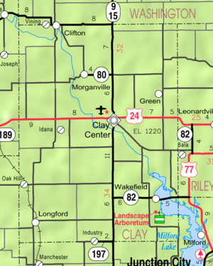
- Washington CountyWashington County, KansasWashington County is a county located in the U.S. state of Kansas. As of the 2010 census, the county population was 5,799...
(north) - Riley CountyRiley County, KansasRiley County is a county located in the U.S. state of Kansas. The county's population was 71,115 for the 2010 census. The largest city and county seat is Manhattan. The county is part of the Manhattan, Kansas, Metropolitan Statistical Area.Riley County is home to two of Kansas' largest...
(east) - Geary CountyGeary County, KansasGeary County is a county located in Northeast Kansas, in the Central United States. As of the 2010 census, the county population was 34,362. Its county seat and most populous city is Junction City. The county is named in honor of Governor John W. Geary...
(southeast) - Dickinson CountyDickinson County, KansasDickinson County is a county located in Central Kansas, in the Central United States. As of the 2010 census, the county population was 19,754. Its county seat and most populous city is Abilene. It was named in honor of Daniel S. Dickinson.-19th century:In 1887, Mr. Herington successfully got...
(south) - Ottawa CountyOttawa County, KansasOttawa County is a county located in the U.S. state of Kansas. As of the 2010 census, the county population was 6,091. The largest city and county seat is Minneapolis...
(southwest) - Cloud CountyCloud County, KansasCloud County is a county located in North Central Kansas, in the Central United States. As of the 2010 census, the county population was 9,533. Its county seat and most populous city is Concordia.-19th century:...
(west)
Major highways
Sources: National Atlas, U.S. Census Bureau- U.S. Route 24U.S. Route 24U.S. Route 24 is one of the original United States highways of 1926. It originally ran from Pontiac, Michigan, in the east to Kansas City, Missouri, in the west. Today, the highway's eastern terminus is west of Clarkston, Michigan, at an intersection with I-75 and its western terminus is near...
- Kansas Highway 15K-15 (Kansas highway)K-15 is a Kansas state highway originating at the Oklahoma state line and continuing to the Nebraska state line where it is then signed as Nebraska Highway 15. It is signed as State Highway 18 once the highway enters Oklahoma. It is 206 miles long...
- Kansas Highway 82
Demographics
United States Census, 2000
The Twenty-second United States Census, known as Census 2000 and conducted by the Census Bureau, determined the resident population of the United States on April 1, 2000, to be 281,421,906, an increase of 13.2% over the 248,709,873 persons enumerated during the 1990 Census...
, there were 8,822 people, 3,617 households, and 2,517 families residing in the county. The population density
Population density
Population density is a measurement of population per unit area or unit volume. It is frequently applied to living organisms, and particularly to humans...
was 14 people per square mile (5/km²). There were 4,084 housing units at an average density of 6 per square mile (2/km²). The racial makeup
Race (United States Census)
Race and ethnicity in the United States Census, as defined by the Federal Office of Management and Budget and the United States Census Bureau, are self-identification data items in which residents choose the race or races with which they most closely identify, and indicate whether or not they are...
of the county was 97.72% White
White American
White Americans are people of the United States who are considered or consider themselves White. The United States Census Bureau defines White people as those "having origins in any of the original peoples of Europe, the Middle East, or North Africa...
, 0.57% Black or African American
African American
African Americans are citizens or residents of the United States who have at least partial ancestry from any of the native populations of Sub-Saharan Africa and are the direct descendants of enslaved Africans within the boundaries of the present United States...
, 0.41% Native American
Native Americans in the United States
Native Americans in the United States are the indigenous peoples in North America within the boundaries of the present-day continental United States, parts of Alaska, and the island state of Hawaii. They are composed of numerous, distinct tribes, states, and ethnic groups, many of which survive as...
, 0.15% Asian
Asian American
Asian Americans are Americans of Asian descent. The U.S. Census Bureau definition of Asians as "Asian” refers to a person having origins in any of the original peoples of the Far East, Southeast Asia, or the Indian subcontinent, including, for example, Cambodia, China, India, Indonesia, Japan,...
, 0.26% from other races, and 0.90% from two or more races
Multiracial
The terms multiracial and mixed-race describe people whose ancestries come from multiple races. Unlike the term biracial, which often is only used to refer to having parents or grandparents of two different races, the term multiracial may encompass biracial people but can also include people with...
. Hispanic
Hispanic
Hispanic is a term that originally denoted a relationship to Hispania, which is to say the Iberian Peninsula: Andorra, Gibraltar, Portugal and Spain. During the Modern Era, Hispanic sometimes takes on a more limited meaning, particularly in the United States, where the term means a person of ...
or Latino
Latino
The demonyms Latino and Latina , are defined in English language dictionaries as:* "a person of Latin-American descent."* "A Latin American."* "A person of Hispanic, especially Latin-American, descent, often one living in the United States."...
of any race were 0.83% of the population.
There were 3,617 household
Household
The household is "the basic residential unit in which economic production, consumption, inheritance, child rearing, and shelter are organized and carried out"; [the household] "may or may not be synonymous with family"....
s out of which 30.50% had children under the age of 18 living with them, 59.90% were married couples
Marriage
Marriage is a social union or legal contract between people that creates kinship. It is an institution in which interpersonal relationships, usually intimate and sexual, are acknowledged in a variety of ways, depending on the culture or subculture in which it is found...
living together, 6.10% had a female householder with no husband present, and 30.40% were non-families. 27.70% of all households were made up of individuals and 15.40% had someone living alone who was 65 years of age or older. The average household size was 2.39 and the average family size was 2.91.
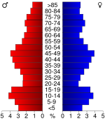
In the county the population was spread out with 24.90% under the age of 18, 6.70% from 18 to 24, 23.90% from 25 to 44, 23.70% from 45 to 64, and 20.80% who were 65 years of age or older. The median age was 41 years. For every 100 females there were 99.10 males. For every 100 females age 18 and over, there were 95.60 males.
The median income for a household
Median household income
The median household income is commonly used to generate data about geographic areas and divides households into two equal segments with the first half of households earning less than the median household income and the other half earning more...
in the county was $33,965, and the median income for a family was $41,103. Males had a median income of $28,817 versus $17,760 for females. The per capita income
Per capita income
Per capita income or income per person is a measure of mean income within an economic aggregate, such as a country or city. It is calculated by taking a measure of all sources of income in the aggregate and dividing it by the total population...
for the county was $17,939. About 6.80% of families and 10.10% of the population were below the poverty line, including 14.60% of those under age 18 and 8.60% of those age 65 or over.
Incorporated cities
Name and population (2004 estimate):- Clay CenterClay Center, KansasClay Center is a city in and the county seat of Clay County, Kansas, United States. As of the 2010 census, the city population was 4,334.-Geography:Clay Center is located at...
, 4,381 (county seat) - WakefieldWakefield, KansasWakefield is a city in Clay County, Kansas, United States. As of the 2010 census, the city population was 980.-Geography:Wakefield is located at . According to the United States Census Bureau, the city has a total area of , all of it land.-Demographics:As of the census of 2000, there were 838...
, 868 - CliftonClifton, KansasClifton is a city in Washington and Clay counties in the U.S. state of Kansas. As of the 2010 census, the city population was 554.-Geography:...
, 516, of which a portion lies in Washington CountyWashington County, KansasWashington County is a county located in the U.S. state of Kansas. As of the 2010 census, the county population was 5,799... - MorganvilleMorganville, KansasMorganville is a city in Clay County, Kansas, United States. As of the 2010 census, the city population was 192.-Geography:Morganville is located at . According to the United States Census Bureau, the city has a total area of , all of it land.-Demographics:As of the census of 2000, there were 198...
, 195 - GreenGreen, KansasGreen is a city in Clay County, Kansas, United States. As of the 2010 census, the city population was 128. It is named in honor of the fourth Governor of Kansas, Nehemiah Green.-Geography:Green is located at...
, 141 - LongfordLongford, KansasLongford is a city in Clay County, Kansas, United States. As of the 2010 census, the city population was 79.-History:In 1887, Atchison, Topeka and Santa Fe Railway built a branch line from Neva through Longford to Superior, Nebraska...
, 89 - ViningVining, KansasVining is a city in Clay and Washington counties in Kansas, United States. As of the 2010 census, the city population was 45.-Geography:Vining is located at . According to the United States Census Bureau, the city has a total area of 0.2 square miles , all land...
, 56, of which a portion lies in Washington CountyWashington County, KansasWashington County is a county located in the U.S. state of Kansas. As of the 2010 census, the county population was 5,799... - Oak HillOak Hill, KansasOak Hill is a city in Clay County, Kansas, United States. As of the 2010 census, the city population was 24.-History:In 1887, Atchison, Topeka and Santa Fe Railway built a branch line from Neva through Oak Hill to Superior, Nebraska...
, 34
Unincorporated places
- Athelstane
- Bateham
- Broughton
- Browndale
- Exeter
- Fact
- Fancy Creek
- Garfield Center
- Gatesville
- Idana
- IndustryIndustry, KansasIndustry is an unincorporated community in Clay and Dickinson counties in the U.S. state of Kansas.-References:...
- Ladysmith
- Northern (no longer exists)
- Republican City
Townships
Clay County is divided into eighteen townshipsCivil township
A civil township is a widely used unit of local government in the United States, subordinate to, and geographic divisions of, a county. Specific responsibilities and the degree of autonomy vary based on each state. Civil townships are distinct from survey townships, but in states that have both,...
. The city of Clay Center
Clay Center, Kansas
Clay Center is a city in and the county seat of Clay County, Kansas, United States. As of the 2010 census, the city population was 4,334.-Geography:Clay Center is located at...
is considered governmentally independent and is excluded from the census figures for the townships. In the following table, the population center is the largest city (or cities) included in that township's population total, if it is of a significant size.
| Township | FIPS | Population center |
Population | Population density /km² (/sq mi) |
Land area km² (sq mi) | Water area km² (sq mi) | Water % | Geographic coordinates |
|---|---|---|---|---|---|---|---|---|
| Athelstane Athelstane Township, Clay County, Kansas Athelstane Township is a township in Clay County, Kansas, USA. As of the 2000 census, its population was 144.-Geography:Athelstane Township covers an area of and contains no incorporated settlements... |
02950 | 144 | 2 (4) | 93 (36) | 0 (0) | 0.03% | 39°10′17"N 97°12′35"W | |
| Blaine Blaine Township, Clay County, Kansas Blaine Township is a township in Clay County, Kansas, USA. As of the 2000 census, its population was 259.-Geography:Blaine Township covers an area of and contains no incorporated settlements... |
07050 | 259 | 2 (6) | 109 (42) | 1 (0) | 0.94% | 39°20′38"N 97°11′11"W | |
| Bloom Bloom Township, Clay County, Kansas Bloom Township is a township in Clay County, Kansas, USA. As of the 2000 census, its population was 125.-Geography:Bloom Township covers an area of and contains no incorporated settlements. According to the USGS, it contains two cemeteries: Bloom and Lincoln.The stream of Mulberry Creek runs... |
07325 | 125 | 1 (3) | 122 (47) | 1 (0) | 0.53% | 39°26′29"N 97°16′51"W | |
| Chapman Chapman Township, Clay County, Kansas Chapman Township is a township in Clay County, Kansas, USA. As of the 2000 census, its population was 202.-Geography:Chapman Township covers an area of and contains one incorporated settlement, Longford. According to the USGS, it contains one cemetery, Swartwood.The stream of West Chapman Creek... |
12525 | Longford Longford, Kansas Longford is a city in Clay County, Kansas, United States. As of the 2010 census, the city population was 79.-History:In 1887, Atchison, Topeka and Santa Fe Railway built a branch line from Neva through Longford to Superior, Nebraska... |
202 | 2 (6) | 93 (36) | 0 (0) | 0.09% | 39°10′21"N 97°19′35"W |
| Clay Center Clay Center Township, Clay County, Kansas Clay Center Township is a township in Clay County, Kansas, USA. As of the 2000 census, its population was 368.-Geography:Clay Center Township covers an area of and contains one incorporated settlement, Clay Center... |
13650 | 368 | 4 (10) | 98 (38) | 1 (1) | 1.46% | 39°21′30"N 97°6′17"W | |
| Exeter Exeter Township, Clay County, Kansas Exeter Township is a township in Clay County, Kansas, USA. As of the 2000 census, its population was 81.-Geography:Exeter Township covers an area of and contains no incorporated settlements. According to the USGS, it contains three cemeteries: Lutheran, Pleasant Ridge and Wesleyan.-References:*... |
22100 | 81 | 1 (2) | 94 (36) | 0 (0) | 0.08% | 39°15′24"N 97°11′36"W | |
| Five Creeks Five Creeks Township, Clay County, Kansas Five Creeks Township is a township in Clay County, Kansas, USA. As of the 2000 census, its population was 159.-Geography:Five Creeks Township covers an area of and contains no incorporated settlements. According to the USGS, it contains one cemetery, Shields.The stream of Pinkerton Branch runs... |
23475 | 159 | 2 (4) | 93 (36) | 0 (0) | 0.04% | 39°21′22"N 97°18′14"W | |
| Garfield Garfield Township, Clay County, Kansas Garfield Township is a township in Clay County, Kansas, USA. As of the 2000 census, its population was 107.-Geography:Garfield Township covers an area of and contains no incorporated settlements. According to the USGS, it contains one cemetery, Center Mission.-References:* -External links:* *... |
25500 | 107 | 1 (3) | 91 (35) | 0 (0) | 0.05% | 39°31′55"N 97°7′5"W | |
| Gill Gill Township, Clay County, Kansas Gill Township is a township in Clay County, Kansas, USA. As of the 2000 census, its population was 140.-Geography:Gill Township covers an area of and contains no incorporated settlements. According to the USGS, it contains one cemetery, Saint Johns.... |
26250 | 140 | 2 (5) | 78 (30) | 0 (0) | 0.04% | 39°10′10"N 97°6′3"W | |
| Goshen Goshen Township, Clay County, Kansas Goshen Township is a township in Clay County, Kansas, USA. As of the 2000 census, its population was 92.-Geography:Goshen Township covers an area of and contains no incorporated settlements. According to the USGS, it contains two cemeteries: Appleton and Central.The streams of Carter Creek and... |
27025 | 92 | 1 (3) | 91 (35) | 0 (0) | 0 % | 39°31′4"N 97°0′14"W | |
| Grant Grant Township, Clay County, Kansas Grant Township is a township in Clay County, Kansas, USA. As of the 2000 census, its population was 132.-Geography:Grant Township covers an area of and contains no incorporated settlements... |
27500 | 132 | 2 (5) | 74 (29) | 13 (5) | 14.83% | 39°16′12"N 96°59′27"W | |
| Hayes Hayes Township, Clay County, Kansas Hayes Township is a township in Clay County, Kansas, USA. As of the 2000 census, its population was 206.-Geography:Hayes Township covers an area of and contains no incorporated settlements. According to the USGS, it contains four cemeteries: Brethren in Christ, Greenwood, Hayes and Pleasant... |
30875 | 206 | 2 (6) | 92 (36) | 0 (0) | 0 % | 39°26′9"N 97°5′58"W | |
| Highland Highland Township, Clay County, Kansas Highland Township is a township in Clay County, Kansas, USA. As of the 2000 census, its population was 310.-Geography:Highland Township covers an area of and contains one incorporated settlement, Green. According to the USGS, it contains three cemeteries: Ebenezer, Fancy Creek and... |
31825 | Green Green, Kansas Green is a city in Clay County, Kansas, United States. As of the 2010 census, the city population was 128. It is named in honor of the fourth Governor of Kansas, Nehemiah Green.-Geography:Green is located at... |
310 | 3 (9) | 92 (35) | 0 (0) | 0.07% | 39°25′28"N 97°0′1"W |
| Mulberry Mulberry Township, Clay County, Kansas Mulberry Township is a township in Clay County, Kansas, USA. As of the 2000 census, its population was 331.-Geography:Mulberry Township covers an area of and contains no incorporated settlements... |
49000 | Clifton (part) Clifton, Kansas Clifton is a city in Washington and Clay counties in the U.S. state of Kansas. As of the 2010 census, the city population was 554.-Geography:... |
331 | 3 (9) | 97 (38) | 2 (1) | 1.99% | 39°32′19"N 97°16′23"W |
| Oakland Oakland Township, Clay County, Kansas Oakland Township is a township in Clay County, Kansas, USA. As of the 2000 census, its population was 110.-Geography:Oakland Township covers an area of and contains one incorporated settlement, Oak Hill. According to the USGS, it contains two cemeteries: Pleasant Valley and Rose... |
51725 | 110 | 1 (3) | 93 (36) | 0 (0) | 0 % | 39°15′30"N 97°20′21"W | |
| Republican Republican Township, Clay County, Kansas Republican Township is a township in Clay County, Kansas, USA. As of the 2000 census, its population was 1,024.-Geography:Republican Township covers an area of and contains one incorporated settlement, Wakefield... |
59025 | Wakefield Wakefield, Kansas Wakefield is a city in Clay County, Kansas, United States. As of the 2010 census, the city population was 980.-Geography:Wakefield is located at . According to the United States Census Bureau, the city has a total area of , all of it land.-Demographics:As of the census of 2000, there were 838... |
1,024 | 14 (36) | 73 (28) | 10 (4) | 12.46% | 39°12′7"N 97°0′50"W |
| Sherman Sherman Township, Clay County, Kansas Sherman Township is a township in Clay County, Kansas, USA. As of the 2000 census, its population was 328.-Geography:Sherman Township covers an area of and contains one incorporated settlement, Morganville. According to the USGS, it contains two cemeteries: Morganville and Sherman.Stillwater... |
64850 | Morganville Morganville, Kansas Morganville is a city in Clay County, Kansas, United States. As of the 2010 census, the city population was 192.-Geography:Morganville is located at . According to the United States Census Bureau, the city has a total area of , all of it land.-Demographics:As of the census of 2000, there were 198... |
328 | 4 (10) | 85 (33) | 1 (0) | 1.00% | 39°30′15"N 97°12′42"W |
| Union Union Township, Clay County, Kansas Union Township is a township in Clay County, Kansas, USA. As of the 2000 census, its population was 140.-Geography:Union Township covers an area of and contains no incorporated settlements. According to the USGS, it contains one cemetery, Gilbert.... |
72075 | 140 | 2 (4) | 92 (35) | 0 (0) | 0.38% | 39°16′16"N 97°4′53"W | |
| Sources: | ||||||||
Unified school districts
- Clay County USD 379, located in Clay CenterClay Center, KansasClay Center is a city in and the county seat of Clay County, Kansas, United States. As of the 2010 census, the city population was 4,334.-Geography:Clay Center is located at...
Further reading
- History of the State of Kansas; William G. Cutler; A.T. Andreas Publisher; 1883. (Online HTML eBook)
- Kansas : A Cyclopedia of State History, Embracing Events, Institutions, Industries, Counties, Cities, Towns, Prominent Persons, Etc; 3 Volumes; Frank W. Blackmar; Standard Publishing Co; 944 / 955 / 824 pages; 1912. (Volume1 - Download 54MB PDF eBook),(Volume2 - Download 53MB PDF eBook), (Volume3 - Download 33MB PDF eBook)
External links
Official sitesAdditional information
Maps
- Clay County Map, KDOT
- Kansas Highway Map, KDOT
- Kansas Railroad Map, KDOT
- Kansas School District Boundary Map, KSDE