
Christchurch Harbour
Encyclopedia
Christchurch Harbour is a natural harbour
in the county of Dorset
, on the south coast of England
named after the nearby town of Christchurch
.
Two Rivers the Avon
and the Stour
flow into the Harbour at its northwest corner. The harbour is generally shallow and due to the tidal harmonics in the English Channel
has a double high water on each tide. On the north side of the harbour, east of the River Avon are Priory Marsh, and to the east of this Stanpit Marsh, a Local Nature Reserve
. To the west side of the harbour are Wick Fields, the southern flank of the harbour being bounded by Hengistbury Head
, a prominent coastal headland.
The harbour flows in to the Christchurch Bay and the English Channel through a narrow channel known locally as The Run which rests between Mudeford Quay and Mudeford Spit. Shallow draught boats can enter from this channel and cruise up stream for 2 miles choosing either the River Avon or the River Stour, the Stour leading up as far as Iford Bridge passing Christchurch Quay and Tuckton.
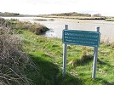
The area also incorporates a Site of Special Scientific Interest
(SSSI) at National Grid Reference SZ 175915 over an area of 873 acres (353.3 ha) comprising the estuary of the Stour and Avon and the Hengistbury Head peninsula. The varied habitats include saltmarsh, wet meadows, grassland, heath, sand dune, woodland and scrub. The site is of great ornithological interest.

. Previously the area which was many miles from the open sea was inhabited by Stone Age
hunters. Archaeological finds dating from 12,500 year BP have been made on Hengistbury Head
and Flints dating as much as 250,000 years BP have been found in the Bournemouth area. The Bluestones used at Stonehenge
may have been transported via the harbour and the River Avon (2550 BCE). It is suggested that there may have been an ancient causeway usable at low water running from Double Dykes on the south shore to Tuttons Well located on the north shore near Stanpit
village.
The Harbour became a major trading port around 100BCE, exports included copper, gold, silver and iron and importing luxury goods including wine and glass from which jewellery was manufactured. It is likely that slaves were also exported through the harbour. The boats used at this time were shallow draft, oak-planked with square leather sails for propulsion. It would have been a twelve hour passage across the channel to Cherbourg and without any modern compasses or much weather forecasting. Despite this there was considerable two way trade with both British and Foreign Ports, it then declined as a result of the Roman
invasion of France in 56 BCE. The remains of a Roman ship were discovered in the harbour in 1910. Trade continued until the Roman Invasion of Britain in AD43. During Saxon times the harbour again became one of the most important in Britain as it was easily reached from the continent and boats could enter the harbour and travel up the river Avon all the way to Salisbury
, and along the Stour to Wimborne and Blandford Forum.
In 1664 The River Avon Navigation act was passed to again enable vessels to travel as far as Salisbury and reestablish it as a port as in Medieval times.Traffic used the river from 1684 to 1720 with a break whilst repairs were made from 1695 to 1700. The route was finally abandoned in 1730. In 1695 Lord Clarendon made a new entrance in Mudeford
Sandbank using the iron stone from Hengistbury to form a training bank, these rocks now called Clarendon Rocks are still in existence, but the new entrance silted up and the channel returned to its original course. During this period and up until the middle of the 19th Century, smuggling
was rife in the Harbour (see the Battle of Mudeford
).
There were numerous Harbour Improvement schemes proposed in the next three centuries, particularly the Railway and Docks Scheme of 1885. This would have seen major dredging of the harbour, training banks within the harbour and a railway terminus on the south side. In 1965 there were a plans to construct a marina at Wick Hams. This and the other schemes were never proceeded with. In the 1930s there were three "tea boats" providing refreshments to holidaymakers and at least another five houseboats in the harbour these were all abandoned and then wrecked during World War II
. The River was dredged in 1937 and again in the 1950s using a Suction Dredger, in the late 1980s Wessex Water
carried out substantial dredging in the River Stour from Iford bridge as far as Christchurch Quay, this was part of a Flood Alleviation Plan. The channel has been marked since at least 1884 first by Christchurch Sailing Club and since 1963 by the Harbour Improvements Association now renamed Christchurch Harbour Association. Since 1963 the Mudeford inshore lifeboat
as been stationed on the quay at Mudeford.
High and low Salt marsh
both exist within the harbour, the latter colonised by Puccinellia
and other grasses. Spartina anglica
does not exist in significant volume, with no sign that it was previously extensive. The sedimentation of the Harbour has not therefore been substantially affected in the way most other south coast estuaries have by the spread and die back of this species. Any loss of the salt marsh appears to have been offset by the re-colonization of abandoned artificial salt pans. Extensive Phragmites
reed beds occupy tidal creek margins and areas of higher marsh, where they front wet grazing meadows.The inflow and outflow of sediment in the Harbour is positive,. Grimbury Marsh, is substantially composed of dredged spoil material. In total the estuarine system is a sediment sink.
as well as Mullet
and Bass
. Also Coarse fish, Roach, Dace
, Carp
and Pike, the harbour and rivers have now been made a sport fishery where all species are returned to ensure the long term sustainability of the fishery.
s and Seals have been seen in the Harbour.
, rowing
, canoeing
, windsurfing
and kite surfing are all practised in the harbour. Fishing
Walking and Bird Spotting
are all activities enjoyed on the Harbour shores. Ferries run from Tuckton Bridge to Mudeford Sandbank and between there and Mudeford Quay, these are some of the same vessels first used in the 1930s. The Mudeford ferry crossing "The Run" was until the 1960s operated by Rowing boats with payment at the discretion of the passenger. There is also a ferry at Wick
.
and Christchurch..
at the eastern end. The River Avon joins the Stour alongside the Priory. Across the Avon are Priory and Grimbury Marsh then the larger Stanpit Marsh (see below), Blackberry point which is an island at High Water is to the east of the marsh. Further east are the residential areas of Stanpit
and Mudeford
. At the eastern end of the harbour is Mudeford Quay, and the harbour entrance which is a relatively narrow channel, named The Run, the coast eastward and open to the sea leads to Highcliffe
, the next coastal village.
and Hengistbury Head
, which are in Southbourne
a suburb of Bournemouth. The harbour proper begins around Wick Fields, a reed marsh and part of the area of importance for nature conservation. The Hengistbury Head Activities Centre is situated on the shore just before Barn Bight. Hengistbury Head on the south shore was threatened during the nineteenth century by the mining of ironstone doggers which dramatically increased erosion. The silt washed into that part of the harbour threatened the ecology and to prevent this, the Quarry Pool was created on the headland by building a dam in 1976. Holloway's Dock cuts into the land before the shore reaches Mudeford
Sandbank which juts northwards towards The Run. The sandbank is the home to many Beach hut
s, a cafe and the terminus for the Hengistbury Head Land Train.
road is Stanpit Marsh. It was formed as the result of action and deposition of material from the rivers Stour
and Avon as they meet with the salt water within Christchurch Harbour. Together with Grimbury Marsh, it forms one of the largest areas of salt marsh in the county. It is a Site of Special Scientific Interest (SSSI)
and an important nature reserve of about 65 hectares (160.6 acre), combining both freshwater and saltwater habitats. It is an important staging point for migratory birds. A circular path on the marsh uses a prototype Bailey Bridge
to cross Mother Siller's Channel. The highest point of the marsh is Crouch Hill at 15' above sea level.
Harbor
A harbor or harbour , or haven, is a place where ships, boats, and barges can seek shelter from stormy weather, or else are stored for future use. Harbors can be natural or artificial...
in the county of Dorset
Dorset
Dorset , is a county in South West England on the English Channel coast. The county town is Dorchester which is situated in the south. The Hampshire towns of Bournemouth and Christchurch joined the county with the reorganisation of local government in 1974...
, on the south coast of England
England
England is a country that is part of the United Kingdom. It shares land borders with Scotland to the north and Wales to the west; the Irish Sea is to the north west, the Celtic Sea to the south west, with the North Sea to the east and the English Channel to the south separating it from continental...
named after the nearby town of Christchurch
Christchurch, Dorset
Christchurch is a borough and town in the county of Dorset on the south coast of England. The town adjoins Bournemouth in the west and the New Forest lies to the east. Historically in Hampshire, it joined Dorset with the reorganisation of local government in 1974 and is the most easterly borough in...
.
Two Rivers the Avon
River Avon, Hampshire
The River Avon is a river in the south of England. The river rises in the county of Wiltshire and flows through the city of Salisbury and the county of Hampshire before reaching the English Channel through Christchurch Harbour in the county of Dorset....
and the Stour
River Stour, Dorset
The River Stour is a 60.5 mile long river which flows through Wiltshire and Dorset in southern England, and drains into the English Channel. It is sometimes called the Dorset Stour to distinguish it from rivers of the same name...
flow into the Harbour at its northwest corner. The harbour is generally shallow and due to the tidal harmonics in the English Channel
English Channel
The English Channel , often referred to simply as the Channel, is an arm of the Atlantic Ocean that separates southern England from northern France, and joins the North Sea to the Atlantic. It is about long and varies in width from at its widest to in the Strait of Dover...
has a double high water on each tide. On the north side of the harbour, east of the River Avon are Priory Marsh, and to the east of this Stanpit Marsh, a Local Nature Reserve
Local Nature Reserve
Local nature reserve or LNR is a designation for nature reserves in the United Kingdom. The designation has its origin in the recommendations of the Wild Life Conservation Special Committee which established the framework for nature conservation in the United Kingdom and suggested a national suite...
. To the west side of the harbour are Wick Fields, the southern flank of the harbour being bounded by Hengistbury Head
Hengistbury Head
Hengistbury Head is a headland jutting into the English Channel between Bournemouth and Milford on Sea in the English county of Dorset.At the end is a spit which creates the narrow entrance to Christchurch Harbour.-Location:...
, a prominent coastal headland.
The harbour flows in to the Christchurch Bay and the English Channel through a narrow channel known locally as The Run which rests between Mudeford Quay and Mudeford Spit. Shallow draught boats can enter from this channel and cruise up stream for 2 miles choosing either the River Avon or the River Stour, the Stour leading up as far as Iford Bridge passing Christchurch Quay and Tuckton.
The area also incorporates a Site of Special Scientific Interest
Site of Special Scientific Interest
A Site of Special Scientific Interest is a conservation designation denoting a protected area in the United Kingdom. SSSIs are the basic building block of site-based nature conservation legislation and most other legal nature/geological conservation designations in Great Britain are based upon...
(SSSI) at National Grid Reference SZ 175915 over an area of 873 acres (353.3 ha) comprising the estuary of the Stour and Avon and the Hengistbury Head peninsula. The varied habitats include saltmarsh, wet meadows, grassland, heath, sand dune, woodland and scrub. The site is of great ornithological interest.
History
The harbour was formed around 7000 years ago when the sea level rose at the end of the last Ice AgeIce age
An ice age or, more precisely, glacial age, is a generic geological period of long-term reduction in the temperature of the Earth's surface and atmosphere, resulting in the presence or expansion of continental ice sheets, polar ice sheets and alpine glaciers...
. Previously the area which was many miles from the open sea was inhabited by Stone Age
Stone Age
The Stone Age is a broad prehistoric period, lasting about 2.5 million years , during which humans and their predecessor species in the genus Homo, as well as the earlier partly contemporary genera Australopithecus and Paranthropus, widely used exclusively stone as their hard material in the...
hunters. Archaeological finds dating from 12,500 year BP have been made on Hengistbury Head
Hengistbury Head
Hengistbury Head is a headland jutting into the English Channel between Bournemouth and Milford on Sea in the English county of Dorset.At the end is a spit which creates the narrow entrance to Christchurch Harbour.-Location:...
and Flints dating as much as 250,000 years BP have been found in the Bournemouth area. The Bluestones used at Stonehenge
Stonehenge
Stonehenge is a prehistoric monument located in the English county of Wiltshire, about west of Amesbury and north of Salisbury. One of the most famous sites in the world, Stonehenge is composed of a circular setting of large standing stones set within earthworks...
may have been transported via the harbour and the River Avon (2550 BCE). It is suggested that there may have been an ancient causeway usable at low water running from Double Dykes on the south shore to Tuttons Well located on the north shore near Stanpit
Stanpit
Stanpit is a historic village in the borough of Christchurch, Dorset, in southern England. It is located along the southern boundary of current day Mudeford.The Stanpit road connects from the end of the original Mudeford road through to Purewell Cross....
village.
The Harbour became a major trading port around 100BCE, exports included copper, gold, silver and iron and importing luxury goods including wine and glass from which jewellery was manufactured. It is likely that slaves were also exported through the harbour. The boats used at this time were shallow draft, oak-planked with square leather sails for propulsion. It would have been a twelve hour passage across the channel to Cherbourg and without any modern compasses or much weather forecasting. Despite this there was considerable two way trade with both British and Foreign Ports, it then declined as a result of the Roman
Ancient Rome
Ancient Rome was a thriving civilization that grew on the Italian Peninsula as early as the 8th century BC. Located along the Mediterranean Sea and centered on the city of Rome, it expanded to one of the largest empires in the ancient world....
invasion of France in 56 BCE. The remains of a Roman ship were discovered in the harbour in 1910. Trade continued until the Roman Invasion of Britain in AD43. During Saxon times the harbour again became one of the most important in Britain as it was easily reached from the continent and boats could enter the harbour and travel up the river Avon all the way to Salisbury
Salisbury
Salisbury is a cathedral city in Wiltshire, England and the only city in the county. It is the second largest settlement in the county...
, and along the Stour to Wimborne and Blandford Forum.
In 1664 The River Avon Navigation act was passed to again enable vessels to travel as far as Salisbury and reestablish it as a port as in Medieval times.Traffic used the river from 1684 to 1720 with a break whilst repairs were made from 1695 to 1700. The route was finally abandoned in 1730. In 1695 Lord Clarendon made a new entrance in Mudeford
Mudeford
Mudeford was originally a small fishing village in the borough of Christchurch, Dorset southern England, lying at the entrance to Christchurch Harbour. The River Mude and Bure Brook flow into the harbour there...
Sandbank using the iron stone from Hengistbury to form a training bank, these rocks now called Clarendon Rocks are still in existence, but the new entrance silted up and the channel returned to its original course. During this period and up until the middle of the 19th Century, smuggling
Smuggling
Smuggling is the clandestine transportation of goods or persons, such as out of a building, into a prison, or across an international border, in violation of applicable laws or other regulations.There are various motivations to smuggle...
was rife in the Harbour (see the Battle of Mudeford
Battle of Mudeford
The Battle of Mudeford was a skirmish fought between smugglers and Customs and Excise officers which occurred in 1784 on what is now a car park at Mudeford Quay, Mudeford, Christchurch, England near the entrance of Christchurch Harbour...
).
There were numerous Harbour Improvement schemes proposed in the next three centuries, particularly the Railway and Docks Scheme of 1885. This would have seen major dredging of the harbour, training banks within the harbour and a railway terminus on the south side. In 1965 there were a plans to construct a marina at Wick Hams. This and the other schemes were never proceeded with. In the 1930s there were three "tea boats" providing refreshments to holidaymakers and at least another five houseboats in the harbour these were all abandoned and then wrecked during World War II
World War II
World War II, or the Second World War , was a global conflict lasting from 1939 to 1945, involving most of the world's nations—including all of the great powers—eventually forming two opposing military alliances: the Allies and the Axis...
. The River was dredged in 1937 and again in the 1950s using a Suction Dredger, in the late 1980s Wessex Water
Wessex Water
Wessex Water Services Limited, known as Wessex Water, is a water supply and sewerage utility company serving an area of the south west of England, covering 10,000 square kilometres including Dorset, Somerset, Bristol, most of Wiltshire and parts of Gloucestershire and Hampshire...
carried out substantial dredging in the River Stour from Iford bridge as far as Christchurch Quay, this was part of a Flood Alleviation Plan. The channel has been marked since at least 1884 first by Christchurch Sailing Club and since 1963 by the Harbour Improvements Association now renamed Christchurch Harbour Association. Since 1963 the Mudeford inshore lifeboat
Mudeford Lifeboat Station
Mudeford Lifeboat Station is the base for Royal National Lifeboat Institution search and rescue operations at Mudeford, Christchurch, Dorset in England. The first lifeboat was stationed on Mudeford Quay 1963 and the present station was opened in 2003...
as been stationed on the quay at Mudeford.
Geology
The Harbour is made up of Sandy Gravels, Sands, Muddy Sands, and towards the margins Silty Muds.High and low Salt marsh
Salt marsh
A salt marsh is an environment in the upper coastal intertidal zone between land and salt water or brackish water, it is dominated by dense stands of halophytic plants such as herbs, grasses, or low shrubs. These plants are terrestrial in origin and are essential to the stability of the salt marsh...
both exist within the harbour, the latter colonised by Puccinellia
Puccinellia
Puccinellia is a genus of grasses which are known as alkali grass. These grasses grow in wet environments, often in saline or alkaline conditions...
and other grasses. Spartina anglica
Spartina anglica
Spartina anglica is a species of cordgrass that originated in southern England in about 1870. It is an allotetraploid species derived from the hybrid Spartina × townsendii, which arose when the European native cordgrass Spartina maritima hybridised with the introduced American Spartina...
does not exist in significant volume, with no sign that it was previously extensive. The sedimentation of the Harbour has not therefore been substantially affected in the way most other south coast estuaries have by the spread and die back of this species. Any loss of the salt marsh appears to have been offset by the re-colonization of abandoned artificial salt pans. Extensive Phragmites
Phragmites
Phragmites, the Common reed, is a large perennial grass found in wetlands throughout temperate and tropical regions of the world. Phragmites australis is sometimes regarded as the sole species of the genus Phragmites, though some botanists divide Phragmites australis into three or four species...
reed beds occupy tidal creek margins and areas of higher marsh, where they front wet grazing meadows.The inflow and outflow of sediment in the Harbour is positive,. Grimbury Marsh, is substantially composed of dredged spoil material. In total the estuarine system is a sediment sink.
Royalty Fishery
The earliest reference to the Royal Fishery at Christchurch dates back to 939AD and there was a valuable fishery in medieval times when the fishery was the property of the Lord of the Manor. The Royalty Fishery Title was conferred by Royal Grant during Queen Mary's reign and was renewed by Elizabeth I. It had come into the possession of the crown by reason of treason. The Queen sold the rights back to Lord Huntington and it was sold on to the Lord of the Manor of Christchurch in 1791. The fishery was then sold to a Mr Thyrwit Walker in 1865, and it was purchased by West Hampshire Water Company in 1929. The Crown had retained the title and fishing rights to the bottom third presumably as an anti-smuggling measure. Today the fishery is claimed to be best Sea trout fishing in England, with some SalmonSalmon
Salmon is the common name for several species of fish in the family Salmonidae. Several other fish in the same family are called trout; the difference is often said to be that salmon migrate and trout are resident, but this distinction does not strictly hold true...
as well as Mullet
Mullet (fish)
The mullets or grey mullets are a family and order of ray-finned fish found worldwide in coastal temperate and tropical waters, and in some species in fresh water. Mullets have served as an important source of food in Mediterranean Europe since Roman times...
and Bass
European seabass
The European seabass, Dicentrarchus labrax, also known as Morone labrax, is a primarily ocean-going fish that sometimes enters brackish and fresh waters. It is also known as the sea dace...
. Also Coarse fish, Roach, Dace
Leuciscus
Leuciscus is a genus of fish belonging to the family Cyprinidae. They are commonly called Eurasian daces; familiar species include the Common Dace and Ide. The genus is widespread form Europe to Siberia....
, Carp
Carp
Carp are various species of oily freshwater fish of the family Cyprinidae, a very large group of fish native to Europe and Asia. The cypriniformes are traditionally grouped with the Characiformes, Siluriformes and Gymnotiformes to create the superorder Ostariophysi, since these groups have certain...
and Pike, the harbour and rivers have now been made a sport fishery where all species are returned to ensure the long term sustainability of the fishery.
Wildlife
The harbour is home to a great variety of wildlife. Over 320 bird species have been recorded by Christchurch Harbour Ornithological Group. The harbour and marshes are an important staging point for migratory birds. There is also an abundance of insect life, and many rare plant species. Stanpit and the other marshes are used for grazing horses and cattle. Both OtterOtter
The Otters are twelve species of semi-aquatic mammals which feed on fish and shellfish, and also other invertebrates, amphibians, birds and small mammals....
s and Seals have been seen in the Harbour.
Leisure
The harbour is home to three Sailing Clubs, Highcliffe Sailing Club situated on Mudeford Quay, Mudeford Sailing Club on the North Shore and Christchurch Sailing Club adjacent to Place Mill on Christchurch Quay. Chistchurch Rowing Club is situated on the Quomps above Christchurch Quay. Hengistbury Head Activities Centre is situated on the South Shore of the Harbour. There are more than 1,400 small boat moorings in the harbour and rivers. SailingSailing
Sailing is the propulsion of a vehicle and the control of its movement with large foils called sails. By changing the rigging, rudder, and sometimes the keel or centre board, a sailor manages the force of the wind on the sails in order to move the boat relative to its surrounding medium and...
, rowing
Watercraft rowing
Watercraft rowing is the act of propelling a boat using the motion of oars in the water. The difference between paddling and rowing is that with rowing the oars have a mechanical connection with the boat whereas with paddling the paddles are hand-held with no mechanical connection.This article...
, canoeing
Canoeing
Canoeing is an outdoor activity that involves a special kind of canoe.Open canoes may be 'poled' , sailed, 'lined and tracked' or even 'gunnel-bobbed'....
, windsurfing
Windsurfing
Windsurfing or sailboarding is a surface water sport that combines elements of surfing and sailing. It consists of a board usually two to four metres long, powered by the orthogonal effect of the wind on a sail. The rig is connected to the board by a free-rotating universal joint and comprises a...
and kite surfing are all practised in the harbour. Fishing
Fishing
Fishing is the activity of trying to catch wild fish. Fish are normally caught in the wild. Techniques for catching fish include hand gathering, spearing, netting, angling and trapping....
Walking and Bird Spotting
Ornithology
Ornithology is a branch of zoology that concerns the study of birds. Several aspects of ornithology differ from related disciplines, due partly to the high visibility and the aesthetic appeal of birds...
are all activities enjoyed on the Harbour shores. Ferries run from Tuckton Bridge to Mudeford Sandbank and between there and Mudeford Quay, these are some of the same vessels first used in the 1930s. The Mudeford ferry crossing "The Run" was until the 1960s operated by Rowing boats with payment at the discretion of the passenger. There is also a ferry at Wick
Wick, Bournemouth
Wick is a village on the southern bank of the River Stour just before it enters Christchurch Harbour. Although only half a mile away from Christchurch Priory, the village is in the borough of Bournemouth, the town centre of which is 4.5 miles away....
.
Around the harbour
To describe the various features of the harbour, it is convenient to divide the harbour, and list the features from inland (west) to outlet (east end). Tuckton Bridge over the River Stour, although inland from the harbour, is a convenient starting point. This is also the boundary between BournemouthBournemouth
Bournemouth is a large coastal resort town in the ceremonial county of Dorset, England. According to the 2001 Census the town has a population of 163,444, making it the largest settlement in Dorset. It is also the largest settlement between Southampton and Plymouth...
and Christchurch..
North side
From Tuckton Bridge along the River Stour there are river front properties up to the Captains Club hotel which is located on the west end of a quay and open space known locally as The Quomps this is overlooked by Christchurch PrioryChristchurch Priory
Christchurch Priory is an ecclesiastical parish and former priory church in Christchurch in the English county of Dorset .-Early history:...
at the eastern end. The River Avon joins the Stour alongside the Priory. Across the Avon are Priory and Grimbury Marsh then the larger Stanpit Marsh (see below), Blackberry point which is an island at High Water is to the east of the marsh. Further east are the residential areas of Stanpit
Stanpit
Stanpit is a historic village in the borough of Christchurch, Dorset, in southern England. It is located along the southern boundary of current day Mudeford.The Stanpit road connects from the end of the original Mudeford road through to Purewell Cross....
and Mudeford
Mudeford
Mudeford was originally a small fishing village in the borough of Christchurch, Dorset southern England, lying at the entrance to Christchurch Harbour. The River Mude and Bure Brook flow into the harbour there...
. At the eastern end of the harbour is Mudeford Quay, and the harbour entrance which is a relatively narrow channel, named The Run, the coast eastward and open to the sea leads to Highcliffe
Highcliffe
Highcliffe-on-Sea is a small town in the borough of Christchurch, Dorset in southern England. It forms part of the South East Dorset conurbation along the English Channel coast...
, the next coastal village.
South side
From Tuckton Bridge, the two main sections of the harbour shore are WickWick, Bournemouth
Wick is a village on the southern bank of the River Stour just before it enters Christchurch Harbour. Although only half a mile away from Christchurch Priory, the village is in the borough of Bournemouth, the town centre of which is 4.5 miles away....
and Hengistbury Head
Hengistbury Head
Hengistbury Head is a headland jutting into the English Channel between Bournemouth and Milford on Sea in the English county of Dorset.At the end is a spit which creates the narrow entrance to Christchurch Harbour.-Location:...
, which are in Southbourne
Southbourne, Dorset
Southbourne is a suburb of Bournemouth. It is the most easterly part of the borough, between Boscombe and Christchurch, Dorset. The area was previously known as Stourfield....
a suburb of Bournemouth. The harbour proper begins around Wick Fields, a reed marsh and part of the area of importance for nature conservation. The Hengistbury Head Activities Centre is situated on the shore just before Barn Bight. Hengistbury Head on the south shore was threatened during the nineteenth century by the mining of ironstone doggers which dramatically increased erosion. The silt washed into that part of the harbour threatened the ecology and to prevent this, the Quarry Pool was created on the headland by building a dam in 1976. Holloway's Dock cuts into the land before the shore reaches Mudeford
Mudeford
Mudeford was originally a small fishing village in the borough of Christchurch, Dorset southern England, lying at the entrance to Christchurch Harbour. The River Mude and Bure Brook flow into the harbour there...
Sandbank which juts northwards towards The Run. The sandbank is the home to many Beach hut
Beach hut
A beach hut is a small, usually wooden and often brightly coloured, box above the high tide mark on popular bathing beaches. They are generally used as a shelter from the sun or wind, changing into and out of swimming costumes and for the safe storing of some personal belongings...
s, a cafe and the terminus for the Hengistbury Head Land Train.
Stanpit Marsh
Along part of the south west side of the StanpitStanpit
Stanpit is a historic village in the borough of Christchurch, Dorset, in southern England. It is located along the southern boundary of current day Mudeford.The Stanpit road connects from the end of the original Mudeford road through to Purewell Cross....
road is Stanpit Marsh. It was formed as the result of action and deposition of material from the rivers Stour
River Stour, Dorset
The River Stour is a 60.5 mile long river which flows through Wiltshire and Dorset in southern England, and drains into the English Channel. It is sometimes called the Dorset Stour to distinguish it from rivers of the same name...
and Avon as they meet with the salt water within Christchurch Harbour. Together with Grimbury Marsh, it forms one of the largest areas of salt marsh in the county. It is a Site of Special Scientific Interest (SSSI)
Site of Special Scientific Interest
A Site of Special Scientific Interest is a conservation designation denoting a protected area in the United Kingdom. SSSIs are the basic building block of site-based nature conservation legislation and most other legal nature/geological conservation designations in Great Britain are based upon...
and an important nature reserve of about 65 hectares (160.6 acre), combining both freshwater and saltwater habitats. It is an important staging point for migratory birds. A circular path on the marsh uses a prototype Bailey Bridge
Bailey bridge
The Bailey bridge is a type of portable, pre-fabricated, truss bridge. It was developed by the British during World War II for military use and saw extensive use by both British and the American military engineering units....
to cross Mother Siller's Channel. The highest point of the marsh is Crouch Hill at 15' above sea level.
External links
- ChristChurchHarbour.info (Unofficial)
- Dorset For You - Christchurch
- Dorset For You - Christchurch Harbour
- University of Southampton geological study of Hengistbury Head
- Navigation information for Christchurch Harbour from Christchurch Sailing Club