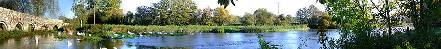
River Stour, Dorset
Encyclopedia
River
A river is a natural watercourse, usually freshwater, flowing towards an ocean, a lake, a sea, or another river. In a few cases, a river simply flows into the ground or dries up completely before reaching another body of water. Small rivers may also be called by several other names, including...
which flows through Wiltshire
Wiltshire
Wiltshire is a ceremonial county in South West England. It is landlocked and borders the counties of Dorset, Somerset, Hampshire, Gloucestershire, Oxfordshire and Berkshire. It contains the unitary authority of Swindon and covers...
and Dorset
Dorset
Dorset , is a county in South West England on the English Channel coast. The county town is Dorchester which is situated in the south. The Hampshire towns of Bournemouth and Christchurch joined the county with the reorganisation of local government in 1974...
in southern England
England
England is a country that is part of the United Kingdom. It shares land borders with Scotland to the north and Wales to the west; the Irish Sea is to the north west, the Celtic Sea to the south west, with the North Sea to the east and the English Channel to the south separating it from continental...
, and drains into the English Channel
English Channel
The English Channel , often referred to simply as the Channel, is an arm of the Atlantic Ocean that separates southern England from northern France, and joins the North Sea to the Atlantic. It is about long and varies in width from at its widest to in the Strait of Dover...
. It is sometimes called the Dorset Stour to distinguish it from rivers of the same name. The source of the river is at Stourhead
Stourhead
Stourhead is a 2,650 acre estate at the source of the River Stour near Mere, Wiltshire, England. The estate includes a Palladian mansion, the village of Stourton, gardens, farmland, and woodland...
, in Wiltshire, where it forms a series of artificial lakes which are part of the Stourhead estate owned by the National Trust
National Trust for Places of Historic Interest or Natural Beauty
The National Trust for Places of Historic Interest or Natural Beauty, usually known as the National Trust, is a conservation organisation in England, Wales and Northern Ireland...
. It flows south into Dorset through the Blackmore Vale
Blackmore Vale
The Blackmore Vale is a vale, or wide valley, in north Dorset, and to a lesser extent south Somerset and southwest Wiltshire in southern England. The vale is part of the Stour valley...
and the towns of Gillingham
Gillingham, Dorset
Gillingham is a town in the Blackmore Vale area of Dorset, England. The town is the most northerly in the county. It is 3 miles south of the A303 lying on the B3092 and B3081. It is near to the town of Shaftesbury which lies 7 miles to the south east. Neighbouring hamlets included Peacemarsh, Bay...
and Sturminster Newton
Sturminster Newton
Sturminster Newton, known to locals as Stur, is a town in the Blackmore Vale area of Dorset, England. It is situated on a low limestone ridge in a meander of the River Stour. The town is at the centre of a large dairy agriculture region, around which the town's economy is built...
.
At Marnhull the Stour is joined by the River Cale and then (two miles downstream) by the River Lydden. At Blandford Forum the river breaks through the chalk
Chalk
Chalk is a soft, white, porous sedimentary rock, a form of limestone composed of the mineral calcite. Calcite is calcium carbonate or CaCO3. It forms under reasonably deep marine conditions from the gradual accumulation of minute calcite plates shed from micro-organisms called coccolithophores....
ridge of the Dorset Downs
Dorset Downs
The Dorset Downs are an area of Chalk downland in the centre of the county Dorset in south west England. The downs are the most western part of a larger Chalk Formation which also includes Cranborne Chase, Salisbury Plain, Hampshire Downs, Chiltern Hills, North Downs and South Downs.The Dorset...
, and from there flows south east into the heathlands of south east Dorset. At Wimborne Minster
Wimborne Minster
Wimborne Minster is a market town in the East Dorset district of Dorset in South West England, and the name of the Church of England church in that town...
it is joined by the River Allen, and at its estuary
Estuary
An estuary is a partly enclosed coastal body of water with one or more rivers or streams flowing into it, and with a free connection to the open sea....
at Christchurch
Christchurch, Dorset
Christchurch is a borough and town in the county of Dorset on the south coast of England. The town adjoins Bournemouth in the west and the New Forest lies to the east. Historically in Hampshire, it joined Dorset with the reorganisation of local government in 1974 and is the most easterly borough in...
it is joined by the River Avon
River Avon, Hampshire
The River Avon is a river in the south of England. The river rises in the county of Wiltshire and flows through the city of Salisbury and the county of Hampshire before reaching the English Channel through Christchurch Harbour in the county of Dorset....
before it flows through the harbour
Christchurch Harbour
Christchurch Harbour is a natural harbour in the county of Dorset, on the south coast of England named after the nearby town of Christchurch.Two Rivers the Avon and the Stour flow into the Harbour at its northwest corner. The harbour is generally shallow and due to the tidal harmonics in the...
into the English Channel. The Stour Valley Way
Stour Valley Way
The Stour Valley Way is a 64 mile long-distance footpath in Dorset, England from Stourton to Hengistbury Head.The path uses public rights of way and permitted paths to follow the catchment area of the River Stour...
is a designated long distance footpath that follows almost all of the course of the river.
For many miles the river is followed by the route of the now disused Somerset and Dorset Joint Railway
Somerset and Dorset Joint Railway
The Somerset & Dorset Joint Railway – almost always referred to as "the S&D" – was an English railway line connecting Bath in north east Somerset and Bournemouth now in south east Dorset but then in Hampshire...
, which bridged the river five times.
Because much of the river's course is across clay
Clay
Clay is a general term including many combinations of one or more clay minerals with traces of metal oxides and organic matter. Geologic clay deposits are mostly composed of phyllosilicate minerals containing variable amounts of water trapped in the mineral structure.- Formation :Clay minerals...
soil, the river's waterlevel varies greatly. In summer, low water level makes the river a diverse and important habitat
Habitat (ecology)
A habitat is an ecological or environmental area that is inhabited by a particular species of animal, plant or other type of organism...
, supporting many rare plants. In winter, the river often flood
Flood
A flood is an overflow of an expanse of water that submerges land. The EU Floods directive defines a flood as a temporary covering by water of land not normally covered by water...
s, and is therefore bordered by wide and fertile flood plains.
A number of towns and villages in Dorset are named after the river, including East Stour, West Stour, Stourpaine
Stourpaine
Stourpaine is a village in north Dorset, England, situated on the River Stour and A350 road in the south east corner of the Blackmore Vale, under Cranborne Chase, three miles north west of Blandford Forum. The village has a population of 608 ....
, Stourton Caundle
Stourton Caundle
Stourton Caundle is a village in the Blackmore Vale area of north Dorset, England, about 5 miles east of Sherborne. The village has a population of 408 .The village was a venue for stave dances.-External links:*...
, Stour Row
Stour Row
Stour Row is a village in north Dorset, England, situated beside Duncliffe hill three miles south west of Shaftesbury....
, Stour Provost
Stour Provost
Stour Provost is a village in the Blackmore Vale area of north Dorset, England, situated on the River Stour between Sturminster Newton and Gillingham. The village has a population of 560 . 5.6% of dwellings are second homes....
, Sturminster Newton
Sturminster Newton
Sturminster Newton, known to locals as Stur, is a town in the Blackmore Vale area of Dorset, England. It is situated on a low limestone ridge in a meander of the River Stour. The town is at the centre of a large dairy agriculture region, around which the town's economy is built...
, and Sturminster Marshall
Sturminster Marshall
Sturminster Marshall is a village and civil parish in east Dorset in England, situated on the River Stour between Blandford Forum and Poole. The parish has a population of 1,895 , and includes the village of Almer west of Sturminster Marshall, near Winterborne Zelston and the hamlet of Henbury to...
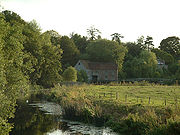
. Sturminster Newton is famous for its water mill and town bridge
Bridge
A bridge is a structure built to span physical obstacles such as a body of water, valley, or road, for the purpose of providing passage over the obstacle...
, which still bears the notice warning potential vandals that damaging the bridge is punishable by penal transportation
Penal transportation
Transportation or penal transportation is the deporting of convicted criminals to a penal colony. Examples include transportation by France to Devil's Island and by the UK to its colonies in the Americas, from the 1610s through the American Revolution in the 1770s, and then to Australia between...
.