
.gif)
Cherry River (West Virginia)
Encyclopedia
Tributary
A tributary or affluent is a stream or river that flows into a main stem river or a lake. A tributary does not flow directly into a sea or ocean...
of the Gauley River
Gauley River
The Gauley River is a river in West Virginia. It merges with the New River to form the Kanawha River, a tributary of the Ohio River. It is one of the most popular advanced whitewater runs in the Eastern United States and is the chief feature of the Gauley River National Recreation Area.-Headwaters...
in southeastern West Virginia
West Virginia
West Virginia is a state in the Appalachian and Southeastern regions of the United States, bordered by Virginia to the southeast, Kentucky to the southwest, Ohio to the northwest, Pennsylvania to the northeast and Maryland to the east...
, USA. Via the Gauley, Kanawha
Kanawha River
The Kanawha River is a tributary of the Ohio River, approximately 97 mi long, in the U.S. state of West Virginia. The largest inland waterway in West Virginia, it has formed a significant industrial region of the state since the middle of the 19th century.It is formed at the town of Gauley...
and Ohio
Ohio River
The Ohio River is the largest tributary, by volume, of the Mississippi River. At the confluence, the Ohio is even bigger than the Mississippi and, thus, is hydrologically the main stream of the whole river system, including the Allegheny River further upstream...
rivers, it is part of the watershed
Drainage basin
A drainage basin is an extent or an area of land where surface water from rain and melting snow or ice converges to a single point, usually the exit of the basin, where the waters join another waterbody, such as a river, lake, reservoir, estuary, wetland, sea, or ocean...
of the Mississippi River
Mississippi River
The Mississippi River is the largest river system in North America. Flowing entirely in the United States, this river rises in western Minnesota and meanders slowly southwards for to the Mississippi River Delta at the Gulf of Mexico. With its many tributaries, the Mississippi's watershed drains...
. The Cherry River drains mostly rural
Rural
Rural areas or the country or countryside are areas that are not urbanized, though when large areas are described, country towns and smaller cities will be included. They have a low population density, and typically much of the land is devoted to agriculture...
and forest
Forest
A forest, also referred to as a wood or the woods, is an area with a high density of trees. As with cities, depending where you are in the world, what is considered a forest may vary significantly in size and have various classification according to how and what of the forest is composed...
ed areas and flows for much of its length through the Monongahela National Forest
Monongahela National Forest
The Monongahela National Forest is a national forest located in the Allegheny Mountains of eastern West Virginia, USA. It protects over of federally-owned land within a proclamation boundary that includes much of the Potomac Highlands Region and portions of 10 counties.The MNF includes some...
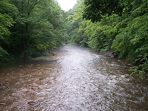
.. Throughout its entire length the Cherry goes over a series of whitewater rapids in a mountainous setting.
History and geography
According to the Geographic Names Information SystemGeographic Names Information System
The Geographic Names Information System is a database that contains name and locative information about more than two million physical and cultural features located throughout the United States of America and its territories. It is a type of gazetteer...
, the river has also been known historically by the toponyms Cherry Tree Waters and Cherrytree Creek in the past..
The upper headwaters of the Cherry begin as two separate creeks, the North Fork Cherry River and the South Fork of Cherry River, each of which rises in southeastern Pocahontas
Pocahontas County, West Virginia
As of the census of 2000, there were 9,131 people, 835 households, and 527 families residing in the county. The population density was 10 people per square mile . There were 7,594 housing units at an average density of 8 per square mile...
County and flows generally west-northwestwardly across northern Greenbrier
Greenbrier County, West Virginia
As of the census of 2000, there were 34,453 people, 14,571 households, and 9,922 families residing in the county. The population density was 34 people per square mile . There were 17,644 housing units at an average density of 17 per square mile...
County before converging in Nicholas County at the city of Richwood
Richwood, West Virginia
Richwood is a city in Nicholas County, West Virginia, United States. The population was 2,477 at the 2000 census. A former coal and lumber boom town, the city's population once flirted with 10,000 but the closure of many underground coal mines caused many of Richwood's residents to leave the state...
.
Now at an elevation of approximately 2,200 feet above sea level, a unique setting is created by which class 3 whitewater rapids are usually created during spring runoff through a town of about 2,000 residents, viewable from some of the city's public streets. This may be the only place in eastern North America where three categories of "twos" (population, elevation, and whitewater difficulty) are met or eclipsed. (Western US example-the Sacramento River
Sacramento River
The Sacramento River is an important watercourse of Northern and Central California in the United States. The largest river in California, it rises on the eastern slopes of the Klamath Mountains, and after a journey south of over , empties into Suisun Bay, an arm of the San Francisco Bay, and...
at Dunsmuir, California
Dunsmuir, California
Dunsmuir is a city in Siskiyou County, California, United States. The population was 1,650 at the 2010 census, down from 1,923 at the 2000 census. It is currently a hub of tourism in Northern California as visitors enjoy fishing, skiing, climbing, or sight-seeing...
)
Downstream of Richwood, the Cherry River is paralleled by a rail trail
Rail trail
A rail trail is the conversion of a disused railway easement into a multi-use path, typically for walking, cycling and sometimes horse riding. The characteristics of former tracks—flat, long, frequently running through historical areas—are appealing for various development. The term sometimes also...
, the Cranberry Tri-Rivers Rail-Trail
Rail trail
A rail trail is the conversion of a disused railway easement into a multi-use path, typically for walking, cycling and sometimes horse riding. The characteristics of former tracks—flat, long, frequently running through historical areas—are appealing for various development. The term sometimes also...
., then flows northwest for about 10 more miles to its confluence
Confluence (geography)
In geography, a confluence is the meeting of two or more bodies of water. It usually refers to the point where two streams flow together, merging into a single stream...
with the Gauley in Curtin
Curtin, Nicholas County, West Virginia
Curtin is a nearly abandoned unincorporated community in eastern Nicholas County, West Virginia, United States. The area is situated at the bottomland surrounding the mouth of the Cherry River at its confluence with the Gauley River...
, a nearly abandoned lumber town two miles south of Craigsville
Craigsville, West Virginia
Craigsville is a census-designated place in Nicholas County, West Virginia, United States. The population was 2,213 at the 2010 census.-Geography:Craigsville is located at ....
.
There are currently no dams on the Cherry and the town of Richwood
Richwood, West Virginia
Richwood is a city in Nicholas County, West Virginia, United States. The population was 2,477 at the 2000 census. A former coal and lumber boom town, the city's population once flirted with 10,000 but the closure of many underground coal mines caused many of Richwood's residents to leave the state...
has been subjected to damaging floods, most recently to a "50 year flood" during the current millennium. Local leaders have proposed a dam be placed on the South Fork just above town, thus protecting it from future flooding and potentially creating more reliable flows for whitewater recreation. However, the project has not been aggressively acted on up to this point much to the vitrol of Richwood residents that have suffered property damage in the past.