

Carrickgollogan
Encyclopedia
Carrickgollogan is a hill in Dublin
in the Dun Laoghaire-Rathdown
administrative county in Ireland
. It is 276 metres (905.5 ft) high and rises above the village of Shankill
on the eastern edge of the Dublin Mountains. Its summit is noted for the panoramic views it offers of south Dublin and north Wicklow
. The author Weston St. John Joyce, writing in The Neighbourhood of Dublin (1912), described the vista thus: “a fine view is obtained of Bray
, Howth
, Dalkey
, and Killiney
, the vale of Shanganagh, and Bray Head
and town. Between the observer and the sea will be seen Loughlinstown
, looking very closely built from this point, like the towns of medieval times, which were built within as small an area as possible, so as to reduce the circuit of the enclosing wall. To the westward will be seen the wooded hill of Barnaslingan
, forming the eastern side of the Scalp, beyond that the Two
and Three Rock Mountains, and south of these the higher Wicklow hills - War Hill, Djouce
, and Duff Hill
”. The geological composition of the summit is predominantly quartzite
. The high ground is a mixture of heathland
and commercial forestry
while the lower slopes are mainly farmland. The forest area around the mountain is mixed woodland including Lodgepole pine
, Noble fir
, Japanese larch
, Lawson cypress, Scots pine
, birch
and beech
trees and is a habitat for badger
s, rabbit
s and a variety of birds.
The area around the summit includes a number of sites of historical interest including the former lead
works at Ballycorus and the ruined church and round tower
at Rathmichael
.
chimney of the former lead works at Ballycorus. Open-cast mining
began at this site, just below the western side of the flue chimney, around 1807 and the site was taken over by the Mining Company of Ireland (MCI) in 1826 who undertook underground mining in the area intermittently up until 1863. Two veins
of lead
and a vein of silver
were worked during this period. However, most of the activity at Ballycorus occurred at the smelting
facility constructed by MCI in the valley below the mine workings. Here, lead from Ballycorus, as well as lead from mines in counties Donegal
, Wicklow
and Wexford
, was processed using a reverberatory furnace
. After the mine was exhausted in the 1860s, the smelting facilities continued to receive and process ore from MCI's mines at Glendalough
, County Wicklow. In the 1880s it was no longer commercially viable to process Irish ores and the smelter was put to work processing ore from the Great Laxey
mine in the Isle of Man
up until closure in 1913.
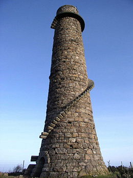 A process had been discovered in the 1770s whereby lead could be extracted from the fumes emitted by reverberatory furnaces if the vapours could be trapped long enough to precipitate
the lead. To this end a flue 1+1/4 mi long running from the lead works and terminating at a chimney near the summit of Carrickgollogan was constructed in 1836. The distinctive granite flue chimney with its external spiral staircase and viewing platform quickly became a noted landmark and was marked on Admiralty
charts as a point of reference for mariners. Photographic records show that the flue chimney was originally much taller with an extra brick section, now dismantled, rising above the viewing platform. It is the only example of such a flue and chimney to have been built in Ireland. Weston St. John Joyce noted that the flue was “stated to be one of the best constructed in the United Kingdom”. The precipitated lead deposits were scraped out of the flue by hand and many of the workers subsequently died of lead poisoning
, giving the surrounding area the nickname “Death Valley”.
As well as the remains of the flue chimney, a number of buildings from the smelting works situated in the valley below also survive to the present day. These industrial buildings, all built from granite
, include furnaces, purification tanks, lime kilns, stores, workers' cottages and manager's house. Many of these buildings are now private residences. A shot tower
, built in 1857, has also survived. An earlier shot tower – described by Joyce as “a handsome and substantial structure, having a spiral stairs within, terminating in an artistic iron veranda on the outside” – built in 1829 no longer survives.
are found enclosed within the remains of what would once have been one of the largest ringfort
s in Ireland. The church dates from Norman
times but the presence of the round tower and ringfort indicates that the site dates back to early Christian times. Its dedication is believed to be to a saint called MacTail (later corrupted as “Michael”) which would date the foundation of the monastery and church to the mid-seventh century. The site also lies close to the route of the pilgrimage
route from St. Mary's Church, Dublin
to Glendalough
. The entrance to the ringfort was 8 feet (2.4 m) in width and had an arched gateway. The ring wall and mound is approximately 350 feet (106.7 m) in diameter and its size suggests the site was the base for an important chieftain. Within the enclosure would have lain a small quadrangular church and a number of monastic huts.
Only the base of the round tower, 2 metres (6.6 ft) high, remains. It has a circumference of 51 feet (15.5 m). The tower is known locally as “The Skull Hole”, a reference to the occasion when skulls and bones from the adjoining burial ground were deposited there rather than being re-interred when the graveyard was cleared to create additional space. There is a story of an underground passage that leads from the round tower to the sea and of a piper who descended into the passage playing his instrument never to be seen again. The remains of a passage – possibly a souterrain
– have been found close to the tower.
All that remains of the church is the east gable of a thirteenth century chancel
and the south wall of a twelfth century nave
. The church has lain in ruins since the end of the seventeenth century. It is noted for its collection of grave slabs or known as the Rathdown stones, nine examples of which can be found at the old church in Rathmichael attached to the south wall. Thirty-two examples of these slabs are known around the Rathdown area and are found nowhere else in Ireland. No two stones are the same but share similar types of decoration in the form of concentric circles, cup marks and herring-bone patterns. It was once thought that these slabs dated to pre-Christian times but subsequent research has shown them to have been influenced by Viking
art styles and they are now believed to be gravemarkers of Viking Christians.
Along Rathmichael Lane, which once would have led to the old Rathmichael Church, is a twelfth century cross with a Crucifixion
scene in high relief set in a granite boulder base. This is one of a series of crosses – known as the Fassaroe Crosses – to be found in the locality, all of which are believed to have been the work of the same stonemason. The base is in its original location but the cross itself was found in the remains of the church in neighbouring Kiltuck and reunited with its base in 1910. The cross is unusual in that there is a Crucifixion scene on both faces. Competing theories for the purpose of the cross are that it marked a route between the churches at Rathmichael and Kiltuck or that it marked the site of another, now long gone, church. There is a story associated with this cross involving General George Cockburn of Shanganagh Castle who was a noted collector of antiquities. Cockburn coveted the cross and dispatched two men to retrieve it for his collection. When they attempted to move the artifact a great wind blew up and heavy rain fell. They succeeded in loading it onto their cart but then their horse bolted and they had to pull the cart themselves. Finally, a serious accident occurred to one of the men while unloading the cross and further misfortune befell his family.
s that inhabit the hills. Francis Erlington Ball in A History of the County Dublin suggests that the building was erected around 1537 by Peter Talbot to defend the lands from incursions by the O'Toole
clan. It is a small rectangular building, 6.7 metres (22 ft) by 4.5 metres (14.8 ft) internally, two stories high with 1.3 metres (4.3 ft) thick walls. James II
visited the castle following the Battle of the Boyne
in 1690 while his army was camped at nearby Lehaunstown and left a gift of silver for his host, Peter Lawless. Some alterations were made to the building in the eighteenth century including a fireplace and chimney. An engraving by George Petrie
around 1819 shows two thatched cottages built onto one side of the castle.
in the nineteenth century indicates that there were several prehistoric monuments on or near Carrickgollogan. Little evidence of them remains today. A structure of three stones in a trilithon
arrangement lies in a field to the south of the summit and it is uncertain as to whether this is the remains of a wedge tomb or a portal tomb. On the east side of the mountain a wedge tomb with a 2.35 metres (7.7 ft) long gallery was discovered during the laying of a gas pipeline. It has since been reburied.
trail called the Lead Mines Way. There is also a permanent orienteering
course. Carrickgollogan is also traversed by the Dublin Mountains Way
.
County Dublin
County Dublin is a county in Ireland. It is part of the Dublin Region and is also located in the province of Leinster. It is named after the city of Dublin which is the capital of Ireland. County Dublin was one of the first of the parts of Ireland to be shired by King John of England following the...
in the Dun Laoghaire-Rathdown
Dun Laoghaire-Rathdown
Dún Laoghaire–Rathdown is a county in Ireland. It is one of three smaller counties into which County Dublin was divided in 1994. Located to the south-east of Dublin city, its county seat is the town of Dún Laoghaire. It is one of the four constituent parts of the Dublin Region...
administrative county in Ireland
Republic of Ireland
Ireland , described as the Republic of Ireland , is a sovereign state in Europe occupying approximately five-sixths of the island of the same name. Its capital is Dublin. Ireland, which had a population of 4.58 million in 2011, is a constitutional republic governed as a parliamentary democracy,...
. It is 276 metres (905.5 ft) high and rises above the village of Shankill
Shankill, Dublin
Shankill is a suburb in the South-East of Dublin located in Dún Laoghaire-Rathdown County, Ireland. It has a population of 13,242 .-History:-Name:...
on the eastern edge of the Dublin Mountains. Its summit is noted for the panoramic views it offers of south Dublin and north Wicklow
County Wicklow
County Wicklow is a county in Ireland. It is part of the Mid-East Region and is also located in the province of Leinster. It is named after the town of Wicklow, which derives from the Old Norse name Víkingalág or Wykynlo. Wicklow County Council is the local authority for the county...
. The author Weston St. John Joyce, writing in The Neighbourhood of Dublin (1912), described the vista thus: “a fine view is obtained of Bray
Bray
Bray is a town in north County Wicklow, Ireland. It is a busy urban centre and seaside resort, with a population of 31,901 making it the fourth largest in Ireland as of the 2006 census...
, Howth
Howth
Howth is an area in Fingal County near Dublin city in Ireland. Originally just a small fishing village, Howth with its surrounding rural district is now a busy suburb of Dublin, with a mix of dense residential development and wild hillside, all on the peninsula of Howth Head. The only...
, Dalkey
Dalkey
Dalkey is suburb of Dublin and seaside resort in Dun Laoghaire-Rathdown County, Ireland. It was founded as a Viking settlement and became an important port during the Middle Ages. According to John Clyn, it was one of the ports through which the plague entered Ireland in the mid-14th century...
, and Killiney
Killiney
Killiney is a suburb of Dublin in south County Dublin, Ireland. It is within the administrative area of Dún Laoghaire-Rathdown County. The area is by the coast, south of neighbouring Dalkey, and north to Shankill area in the most southern outskirt of Dublin....
, the vale of Shanganagh, and Bray Head
Bray Head
Bray Head is a hill and headland located in northern County Wicklow, Ireland, between the towns of Bray and Greystones. It forms part of the Wicklow Mountains and is a popular spot with hillwalkers. At the top of the head is a concrete cross which was placed there in 1950 during the holy year...
and town. Between the observer and the sea will be seen Loughlinstown
Loughlinstown
Loughlinstown is a south Dublin suburb. Located in the County of Dun Laoghaire-Rathdown it lies on the N11 National Primary Route.Loughlinstown is the location of St. Columcille's Hospital, which serves both south Dublin and north Wicklow...
, looking very closely built from this point, like the towns of medieval times, which were built within as small an area as possible, so as to reduce the circuit of the enclosing wall. To the westward will be seen the wooded hill of Barnaslingan
Barnaslingan
Barnaslingan is a high hill in County Dublin, Ireland. It is most noted for the geological feature known as The Scalp that lies to the west of the summit...
, forming the eastern side of the Scalp, beyond that the Two
Two Rock
Two Rock is a mountain in Dun Laoghaire-Rathdown, Ireland. It is high and is the 382nd highest mountain in Ireland. It is the highest point of the group of hills in the Dublin Mountains which comprises Two Rock, Three Rock, Kilmashogue and Tibradden Mountains. The mountain takes its name from the...
and Three Rock Mountains, and south of these the higher Wicklow hills - War Hill, Djouce
Djouce
Djouce , sometimes referred to as Djouce Mountain, is a mountain situated in the northeastern section of the Wicklow Mountains. To the west it overlooks the highlands around the Sally Gap; to the east the Roundwood / Calary Bog plateau....
, and Duff Hill
Duff Hill
Duff Hill is a mountain in County Wicklow, Ireland. At 720 metres it is the 12th highest mountain in the Wicklow Mountains and the 96th highest summit in Ireland.-See also:*List of mountains in Ireland...
”. The geological composition of the summit is predominantly quartzite
Quartzite
Quartzite is a hard metamorphic rock which was originally sandstone. Sandstone is converted into quartzite through heating and pressure usually related to tectonic compression within orogenic belts. Pure quartzite is usually white to gray, though quartzites often occur in various shades of pink...
. The high ground is a mixture of heathland
Heath (habitat)
A heath or heathland is a dwarf-shrub habitat found on mainly low quality acidic soils, characterised by open, low growing woody vegetation, often dominated by plants of the Ericaceae. There are some clear differences between heath and moorland...
and commercial forestry
Forestry
Forestry is the interdisciplinary profession embracing the science, art, and craft of creating, managing, using, and conserving forests and associated resources in a sustainable manner to meet desired goals, needs, and values for human benefit. Forestry is practiced in plantations and natural stands...
while the lower slopes are mainly farmland. The forest area around the mountain is mixed woodland including Lodgepole pine
Lodgepole Pine
Lodgepole Pine, Pinus contorta, also known as Shore Pine, is a common tree in western North America. Like all pines, it is evergreen.-Subspecies:...
, Noble fir
Noble Fir
Abies procera, the Noble Fir, is a western North American fir, native to the Cascade Range and Coast Range mountains of extreme northwest California and western Oregon and Washington in the United States...
, Japanese larch
Japanese Larch
Japanese Larch is a species of larch native to Japan, in the mountains of Chūbu and Kantō regions in central Honshū....
, Lawson cypress, Scots pine
Scots Pine
Pinus sylvestris, commonly known as the Scots Pine, is a species of pine native to Europe and Asia, ranging from Scotland, Ireland and Portugal in the west, east to eastern Siberia, south to the Caucasus Mountains, and as far north as well inside the Arctic Circle in Scandinavia...
, birch
Birch
Birch is a tree or shrub of the genus Betula , in the family Betulaceae, closely related to the beech/oak family, Fagaceae. The Betula genus contains 30–60 known taxa...
and beech
Beech
Beech is a genus of ten species of deciduous trees in the family Fagaceae, native to temperate Europe, Asia and North America.-Habit:...
trees and is a habitat for badger
Badger
Badgers are short-legged omnivores in the weasel family, Mustelidae. There are nine species of badger, in three subfamilies : Melinae , Mellivorinae , and Taxideinae...
s, rabbit
Rabbit
Rabbits are small mammals in the family Leporidae of the order Lagomorpha, found in several parts of the world...
s and a variety of birds.
The area around the summit includes a number of sites of historical interest including the former lead
Lead
Lead is a main-group element in the carbon group with the symbol Pb and atomic number 82. Lead is a soft, malleable poor metal. It is also counted as one of the heavy metals. Metallic lead has a bluish-white color after being freshly cut, but it soon tarnishes to a dull grayish color when exposed...
works at Ballycorus and the ruined church and round tower
Irish round tower
Irish round towers , Cloigthithe – literally "bell house") are early medieval stone towers of a type found mainly in Ireland, with three in Scotland and one on the Isle of Man...
at Rathmichael
Rathmichael
Rathmichael is a suburb in the south-east of Dublin in the county of Dún Laoghaire-Rathdown. It is situated west of Shankill from which it is separated by the M50/M11 motorways.-Location and nature:...
.
Ballycorus leadmines
The most distinctive landmark to the north of the summit is the ruins of the flueFlue
A flue is a duct, pipe, or chimney for conveying exhaust gases from a fireplace, furnace, water heater, boiler, or generator to the outdoors. In the United States, they are also known as vents and for boilers as breeching for water heaters and modern furnaces...
chimney of the former lead works at Ballycorus. Open-cast mining
Open-pit mining
Open-pit mining or opencast mining refers to a method of extracting rock or minerals from the earth by their removal from an open pit or borrow....
began at this site, just below the western side of the flue chimney, around 1807 and the site was taken over by the Mining Company of Ireland (MCI) in 1826 who undertook underground mining in the area intermittently up until 1863. Two veins
Vein (geology)
In geology, a vein is a distinct sheetlike body of crystallized minerals within a rock. Veins form when mineral constituents carried by an aqueous solution within the rock mass are deposited through precipitation...
of lead
Lead
Lead is a main-group element in the carbon group with the symbol Pb and atomic number 82. Lead is a soft, malleable poor metal. It is also counted as one of the heavy metals. Metallic lead has a bluish-white color after being freshly cut, but it soon tarnishes to a dull grayish color when exposed...
and a vein of silver
Silver
Silver is a metallic chemical element with the chemical symbol Ag and atomic number 47. A soft, white, lustrous transition metal, it has the highest electrical conductivity of any element and the highest thermal conductivity of any metal...
were worked during this period. However, most of the activity at Ballycorus occurred at the smelting
Smelting
Smelting is a form of extractive metallurgy; its main use is to produce a metal from its ore. This includes iron extraction from iron ore, and copper extraction and other base metals from their ores...
facility constructed by MCI in the valley below the mine workings. Here, lead from Ballycorus, as well as lead from mines in counties Donegal
County Donegal
County Donegal is a county in Ireland. It is part of the Border Region and is also located in the province of Ulster. It is named after the town of Donegal. Donegal County Council is the local authority for the county...
, Wicklow
County Wicklow
County Wicklow is a county in Ireland. It is part of the Mid-East Region and is also located in the province of Leinster. It is named after the town of Wicklow, which derives from the Old Norse name Víkingalág or Wykynlo. Wicklow County Council is the local authority for the county...
and Wexford
County Wexford
County Wexford is a county in Ireland. It is part of the South-East Region and is also located in the province of Leinster. It is named after the town of Wexford. In pre-Norman times it was part of the Kingdom of Uí Cheinnselaig, whose capital was at Ferns. Wexford County Council is the local...
, was processed using a reverberatory furnace
Reverberatory furnace
A reverberatory furnace is a metallurgical or process furnace that isolates the material being processed from contact with the fuel, but not from contact with combustion gases...
. After the mine was exhausted in the 1860s, the smelting facilities continued to receive and process ore from MCI's mines at Glendalough
Glendalough
Glendalough or Glendaloch is a glacial valley in County Wicklow, Ireland. It is renowned for its Early Medieval monastic settlement founded in the 6th century by St Kevin, a hermit priest, and partly destroyed in 1398 by English troops....
, County Wicklow. In the 1880s it was no longer commercially viable to process Irish ores and the smelter was put to work processing ore from the Great Laxey
Laxey
Laxey is a village on the east coast of the Isle of Man. Its name derives from the Old Norse Laxa meaning 'Salmon River'.The village lies on the A2, the main Douglas to Ramsey road. Laxey Glen is one of the Manx National Glens, with Dhoon Glen being located close by...
mine in the Isle of Man
Isle of Man
The Isle of Man , otherwise known simply as Mann , is a self-governing British Crown Dependency, located in the Irish Sea between the islands of Great Britain and Ireland, within the British Isles. The head of state is Queen Elizabeth II, who holds the title of Lord of Mann. The Lord of Mann is...
up until closure in 1913.
Precipitation (meteorology)
In meteorology, precipitation In meteorology, precipitation In meteorology, precipitation (also known as one of the classes of hydrometeors, which are atmospheric water phenomena is any product of the condensation of atmospheric water vapor that falls under gravity. The main forms of precipitation...
the lead. To this end a flue 1+1/4 mi long running from the lead works and terminating at a chimney near the summit of Carrickgollogan was constructed in 1836. The distinctive granite flue chimney with its external spiral staircase and viewing platform quickly became a noted landmark and was marked on Admiralty
Admiralty
The Admiralty was formerly the authority in the Kingdom of England, and later in the United Kingdom, responsible for the command of the Royal Navy...
charts as a point of reference for mariners. Photographic records show that the flue chimney was originally much taller with an extra brick section, now dismantled, rising above the viewing platform. It is the only example of such a flue and chimney to have been built in Ireland. Weston St. John Joyce noted that the flue was “stated to be one of the best constructed in the United Kingdom”. The precipitated lead deposits were scraped out of the flue by hand and many of the workers subsequently died of lead poisoning
Lead poisoning
Lead poisoning is a medical condition caused by increased levels of the heavy metal lead in the body. Lead interferes with a variety of body processes and is toxic to many organs and tissues including the heart, bones, intestines, kidneys, and reproductive and nervous systems...
, giving the surrounding area the nickname “Death Valley”.
As well as the remains of the flue chimney, a number of buildings from the smelting works situated in the valley below also survive to the present day. These industrial buildings, all built from granite
Granite
Granite is a common and widely occurring type of intrusive, felsic, igneous rock. Granite usually has a medium- to coarse-grained texture. Occasionally some individual crystals are larger than the groundmass, in which case the texture is known as porphyritic. A granitic rock with a porphyritic...
, include furnaces, purification tanks, lime kilns, stores, workers' cottages and manager's house. Many of these buildings are now private residences. A shot tower
Shot tower
thumb|The Shot Tower, Bristol, EnglandA shot tower is a tower designed for the production of shot balls by freefall of molten lead, which is then caught in a water basin. The shot is used for projectiles in firearms.-Process:...
, built in 1857, has also survived. An earlier shot tower – described by Joyce as “a handsome and substantial structure, having a spiral stairs within, terminating in an artistic iron veranda on the outside” – built in 1829 no longer survives.
Rathmichael old church and round tower
Further down the slopes to the north of the summit lies Rathmichael where the ruins of a church and round towerIrish round tower
Irish round towers , Cloigthithe – literally "bell house") are early medieval stone towers of a type found mainly in Ireland, with three in Scotland and one on the Isle of Man...
are found enclosed within the remains of what would once have been one of the largest ringfort
Ringfort
Ringforts are circular fortified settlements that were mostly built during the Iron Age , although some were built as late as the Early Middle Ages . They are found in Northern Europe, especially in Ireland...
s in Ireland. The church dates from Norman
Normans
The Normans were the people who gave their name to Normandy, a region in northern France. They were descended from Norse Viking conquerors of the territory and the native population of Frankish and Gallo-Roman stock...
times but the presence of the round tower and ringfort indicates that the site dates back to early Christian times. Its dedication is believed to be to a saint called MacTail (later corrupted as “Michael”) which would date the foundation of the monastery and church to the mid-seventh century. The site also lies close to the route of the pilgrimage
Pilgrimage
A pilgrimage is a journey or search of great moral or spiritual significance. Typically, it is a journey to a shrine or other location of importance to a person's beliefs and faith...
route from St. Mary's Church, Dublin
St. Mary's Church, Dublin
St. Mary's Church, Dublin is a former Church of Ireland building in Mary Street, Dublin.-The Church:Dating from the 17th century, the building was designed by Sir William Robinson, and is notable as the first Dublin church to be built with galleries....
to Glendalough
Glendalough
Glendalough or Glendaloch is a glacial valley in County Wicklow, Ireland. It is renowned for its Early Medieval monastic settlement founded in the 6th century by St Kevin, a hermit priest, and partly destroyed in 1398 by English troops....
. The entrance to the ringfort was 8 feet (2.4 m) in width and had an arched gateway. The ring wall and mound is approximately 350 feet (106.7 m) in diameter and its size suggests the site was the base for an important chieftain. Within the enclosure would have lain a small quadrangular church and a number of monastic huts.
Only the base of the round tower, 2 metres (6.6 ft) high, remains. It has a circumference of 51 feet (15.5 m). The tower is known locally as “The Skull Hole”, a reference to the occasion when skulls and bones from the adjoining burial ground were deposited there rather than being re-interred when the graveyard was cleared to create additional space. There is a story of an underground passage that leads from the round tower to the sea and of a piper who descended into the passage playing his instrument never to be seen again. The remains of a passage – possibly a souterrain
Souterrain
Souterrain is a name given by archaeologists to a type of underground structure associated mainly with the Atlantic Iron Age. These structures appear to have been brought northwards from Gaul during the late Iron Age. Regional names include earth houses, fogous and Pictish houses...
– have been found close to the tower.
All that remains of the church is the east gable of a thirteenth century chancel
Chancel
In church architecture, the chancel is the space around the altar in the sanctuary at the liturgical east end of a traditional Christian church building...
and the south wall of a twelfth century nave
Nave
In Romanesque and Gothic Christian abbey, cathedral basilica and church architecture, the nave is the central approach to the high altar, the main body of the church. "Nave" was probably suggested by the keel shape of its vaulting...
. The church has lain in ruins since the end of the seventeenth century. It is noted for its collection of grave slabs or known as the Rathdown stones, nine examples of which can be found at the old church in Rathmichael attached to the south wall. Thirty-two examples of these slabs are known around the Rathdown area and are found nowhere else in Ireland. No two stones are the same but share similar types of decoration in the form of concentric circles, cup marks and herring-bone patterns. It was once thought that these slabs dated to pre-Christian times but subsequent research has shown them to have been influenced by Viking
Viking
The term Viking is customarily used to refer to the Norse explorers, warriors, merchants, and pirates who raided, traded, explored and settled in wide areas of Europe, Asia and the North Atlantic islands from the late 8th to the mid-11th century.These Norsemen used their famed longships to...
art styles and they are now believed to be gravemarkers of Viking Christians.
Along Rathmichael Lane, which once would have led to the old Rathmichael Church, is a twelfth century cross with a Crucifixion
Crucifixion
Crucifixion is an ancient method of painful execution in which the condemned person is tied or nailed to a large wooden cross and left to hang until dead...
scene in high relief set in a granite boulder base. This is one of a series of crosses – known as the Fassaroe Crosses – to be found in the locality, all of which are believed to have been the work of the same stonemason. The base is in its original location but the cross itself was found in the remains of the church in neighbouring Kiltuck and reunited with its base in 1910. The cross is unusual in that there is a Crucifixion scene on both faces. Competing theories for the purpose of the cross are that it marked a route between the churches at Rathmichael and Kiltuck or that it marked the site of another, now long gone, church. There is a story associated with this cross involving General George Cockburn of Shanganagh Castle who was a noted collector of antiquities. Cockburn coveted the cross and dispatched two men to retrieve it for his collection. When they attempted to move the artifact a great wind blew up and heavy rain fell. They succeeded in loading it onto their cart but then their horse bolted and they had to pull the cart themselves. Finally, a serious accident occurred to one of the men while unloading the cross and further misfortune befell his family.
Puck's Castle
Also to the north is the ruins of a fortified dwelling known as “Puck's Castle”. The origin of the name may be related to the story of a fairy (or ) piper said to hop from rock to rock playing his pipe or it may refer to the feral goatFeral goat
The feral goat is the domestic goat when it has become established in the wild. Feral goats occur in Australia, New Zealand, Ireland, Great Britain, Hawaii, the Galapagos and in many other parts of the world...
s that inhabit the hills. Francis Erlington Ball in A History of the County Dublin suggests that the building was erected around 1537 by Peter Talbot to defend the lands from incursions by the O'Toole
O'Tuathail
-Origins:O'Tuathail is an Irish surname commonly found in County Wicklow. There is also an O'Tuathail clan from Kildare, who are now known as O'Toole and Donegal Known as Tolan.-Coat of arms:...
clan. It is a small rectangular building, 6.7 metres (22 ft) by 4.5 metres (14.8 ft) internally, two stories high with 1.3 metres (4.3 ft) thick walls. James II
James II of England
James II & VII was King of England and King of Ireland as James II and King of Scotland as James VII, from 6 February 1685. He was the last Catholic monarch to reign over the Kingdoms of England, Scotland, and Ireland...
visited the castle following the Battle of the Boyne
Battle of the Boyne
The Battle of the Boyne was fought in 1690 between two rival claimants of the English, Scottish and Irish thronesthe Catholic King James and the Protestant King William across the River Boyne near Drogheda on the east coast of Ireland...
in 1690 while his army was camped at nearby Lehaunstown and left a gift of silver for his host, Peter Lawless. Some alterations were made to the building in the eighteenth century including a fireplace and chimney. An engraving by George Petrie
George Petrie
George Petrie , was an Irish painter, musician, antiquary and archaeologist of the Victorian era.-Personal life:...
around 1819 shows two thatched cottages built onto one side of the castle.
Alcock memorial
To the south of the summit is a plaque embedded in the rockface containing a memorial to a Doctor Nathaniel Alcock erected by his daughters in 1914. The inscription reads, “To the Memory of One who Worshipped Here. Doctor Nathaniel Alcock Died April 4, 1904 in His 85th Year. “A Wise Man is Never so busy as in the Solitary Contemplation of God And the Worship of Nature” Seneca. Erected by his Two Friends”.Prehistoric monuments
Fieldwork carried out by the Ordnance SurveyOrdnance Survey Ireland
Ordnance Survey Ireland is the national mapping agency of the Republic of Ireland and, together with the Ordnance Survey of Northern Ireland , succeeded, after 1922, the Irish operations of the United Kingdom Ordnance Survey. It is part of the Public service of the Republic of Ireland...
in the nineteenth century indicates that there were several prehistoric monuments on or near Carrickgollogan. Little evidence of them remains today. A structure of three stones in a trilithon
Trilithon
A trilithon is a structure consisting of two large vertical stones supporting a third stone set horizontally across the top . It is commonly used in the context of megalithic monuments...
arrangement lies in a field to the south of the summit and it is uncertain as to whether this is the remains of a wedge tomb or a portal tomb. On the east side of the mountain a wedge tomb with a 2.35 metres (7.7 ft) long gallery was discovered during the laying of a gas pipeline. It has since been reburied.
Access and recreation
Carrickgollogan lies within a Coillte-owned forest recreation area which is managed by the Dublin Mountains Partnership. There are approximately 8 kilometres (5 mi) of trails in the recreation area, including a waymarkedWaymarking
Waymarking is an activity where people locate and log interesting locations around the world, usually with a GPS receiver and a digital camera. Waymarking differs from geocaching in that there is no physical container to locate at the given coordinates. Waymarking identifies points of interest for...
trail called the Lead Mines Way. There is also a permanent orienteering
Orienteering
Orienteering is a family of sports that requires navigational skills using a map and compass to navigate from point to point in diverse and usually unfamiliar terrain, and normally moving at speed. Participants are given a topographical map, usually a specially prepared orienteering map, which they...
course. Carrickgollogan is also traversed by the Dublin Mountains Way
Dublin Mountains Way
The Dublin Mountains Way is a waymarked long-distance trail in the Dublin Mountains, County Dublin, Ireland. The route is approximately long and runs from Shankill in the East to Tallaght in the West...
.