
Carnia
Encyclopedia
Carnia is a historical-geographic region of Friuli
, whose municipalities all belong to the province of Udine
, which is part of the Friuli-Venezia Giulia
Region.
 It covers the western and central part of the mountainous region of the Province of Udine
(the Carnic Alps
), but not the eastern part (the Julian Alps
), therefore it borders Veneto
and Austria
(Carinthia
), but not Slovenia
. The main town is Tolmezzo
.
Italian
is the official language. Nevertheless Friulian
, a Rhaeto-Romance
language, is widely spoken. The German
Austro-Bavarian
dialect is spoken in the linguistic enclaves of Sauris
, Paluzza
-Timau and Sappada
.
; bounded to the north by Austria
, to the south by the province of Pordenone
, to the west Veneto
, and to the east by Canal del Ferro-Valcanale (Ferro-Valcanale outfall), which also are part of the province of Udine.
Each of these valleys and their homonymous streams meet in a common valley floor where the main centre of Carnia is located: Tolmezzo
It is actually dutiful to add to the ones above the municipality of Sappada
(Sapade, Plodn in the local German dialect), which is now part of the province of Belluno
, and the village Alesso (Dalès) part of the municipality of Trasaghis
.
, dolostone
and flint-stone.
Carnia is spanned by the Carnic Alps
, which extend from Passo di Monte Croce di Comelico to sella di Camporosso, where Alpi Giulie begin and rise (on the Italian side) between Fella and the upper Isonzo rivers.
The north side of the carnic ridge sets up the boundary with Austria
; on the south it is delimited by the stream Pontebbana, and, on the upper side of Pontebba
, by the flow of the Fella.
Mount Coglians
(m. 2780) is the highest peak of the Carnic Alps. Together with the cluster of Creta delle Cjanevate it forms an impressive horst at the Austrian boundary. Other main peaks of Carnia are:
Pass (in the municipality of Calalzo) at an altitude of 1,195 meters. Along its long way throughout Carnia, the Tagliamento river riceives water from 6 tributaries, all coming from left with respect to it: the Bût
, the Degano, the Lumiei, the Pesarina, the Chiarsò, and the Monai
, which name the valleys they lie in.
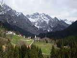
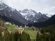
Carnia can boast many natural beauties thanks to the absence of big industrial centres and to the effective protection by ecologist public agencies and organizations.
In Carnia 2,000 vegetable species, about a thousand types of mushroms, and some fifty types of orchids are grown.
Vegetation in Carnia changes with altitude. Up to the height of 400 - 500 meters stand durmast and chestnut woods and some submontane cultivation zones but very soon they are replaced by the mountain flora, typical of the forests: beechwood, fir-wood, and pine-wood. Above 1,500 metres the arboreous vegetations becomes rather poor, trees become more and more sparse, small and bare up to the altimetrical limit of tree growth, which in Carnia stands at 1,700 metres - the lowest in the alpine region. Further on only bushes and emerald-green pastures can be found.
In late springs on the pastures a colour explosion of wild azalea
s and gentian
s can be admired.
, in Carnia lower altimetrical limits of about 400-500 metres can be observed. For example while in the Western Alps the vegetation stops from growing above 2,300 metres, in Carnia it stops already at 1,900 metres. This lowering of the arboreal altimetrical limit is due to the thermal inversion, caused by the constant flow of cold winds coming from the north-east ("burano" wind), which reaches the region from the siberian and danubian districts.
, a Celtic people, from whom its name comes. The Carni lived for centuries in the fertile plains between the Rhine and the Danube
rivers where other Celtic peoples lived. Starting from 400 BCE, the demographic growth and the pressure of the Germanic peoples, originated a migratory flood towards the south.
The Carni crossed the Alps through the Mount Croce Carnico
pass and settled in the region which is nowadays named Carnia and in the piedmont zone of Friuli. They practiced hunting and breeding. During the hard winters the herders used to move with their cattle down to the piedmont plains. Also they were skillful iron and wood manufacturers.
The Carni were headed by a king and a sacerdotal caste (made of druid
s).
The first historical date related to the arrival of the Carni is 186 BCE, when some 50,000 Carni, composed of armed men, women and children descended towards the plains (in which they previously used to winter) and on a hill they founded a stable defensive settlement, Akileja.
The Romans, concerned by the expansion of this people, in 183 BCE forced back the Carni to the mountains, they destroyed their settlement and they founded a defensive settlement at the north-east boundaries.
The new settlement was named Aquileia
, after the former Celtic name Akileja.
The triumvirs that founded that settlement were Publius Scipio Nasica, Caius Flaminius and Lucius Manlius Acidinus.
In order to stem the Roman expansion and to acquire the fertile and more hospitable plains, the Carni tried to form alliances with the Histri
an, the Iapode, and the Taurisci
Celts.
As Rome, in turn, was more and more becoming awere of the impending danger coming from the Carni and as it wanted to accelerate its own expansion, it sent to the north-east the legions of consul Marcus Aemilius Scaurus
, who finally defeated the Carni in the battle of 15 November 115 BCE.
Later on, the Carni, characterized by a docile temper and who had been defeated in battle, submitted to Rome, accepting its commands and its concessions.
In the course of the following centuries, the Carni and Roman customs and blood would get mixed and this union of two deeply different cultures would slowly give rise to a new people, the Aquileiese or Friulan People.
The mixing of the two languages would give rise to the Friulian language.
In the mean time Aquileia enlarged its importance. It became a Municipium
Romanum in 90 BCE; it was an important commercial and hand-craft production centre. Also it was the main port on the Adriatic sea and a garrison settlemnent.
Friuli
Friuli is an area of northeastern Italy with its own particular cultural and historical identity. It comprises the major part of the autonomous region Friuli-Venezia Giulia, i.e. the province of Udine, Pordenone, Gorizia, excluding Trieste...
, whose municipalities all belong to the province of Udine
Province of Udine
The Province of Udine is a province in the autonomous Friuli-Venezia Giulia region of Italy, bordering Austria and Slovenia. Its capital is the city of Udine....
, which is part of the Friuli-Venezia Giulia
Friuli-Venezia Giulia
Friuli–Venezia Giulia is one of the twenty regions of Italy, and one of five autonomous regions with special statute. The capital is Trieste. It has an area of 7,858 km² and about 1.2 million inhabitants. A natural opening to the sea for many Central European countries, the region is...
Region.
Province of Udine
The Province of Udine is a province in the autonomous Friuli-Venezia Giulia region of Italy, bordering Austria and Slovenia. Its capital is the city of Udine....
(the Carnic Alps
Carnic Alps
The Carnic Alps are a range of the Southern Limestone Alps in East Tyrol, Carinthia, South Tyrol and Friuli . They extend from east to west for about between the Gail River, a tributary of the Drava and the Tagliamento, forming the border between Austria and Italy.They are named after the Roman...
), but not the eastern part (the Julian Alps
Julian Alps
The Julian Alps are a mountain range of the Southern Limestone Alps that stretches from northeastern Italy to Slovenia, where they rise to 2,864 m at Mount Triglav. They are named after Julius Caesar, who founded the municipium of Cividale del Friuli at the foot of the mountains...
), therefore it borders Veneto
Veneto
Veneto is one of the 20 regions of Italy. Its population is about 5 million, ranking 5th in Italy.Veneto had been for more than a millennium an independent state, the Republic of Venice, until it was eventually annexed by Italy in 1866 after brief Austrian and French rule...
and Austria
Austria
Austria , officially the Republic of Austria , is a landlocked country of roughly 8.4 million people in Central Europe. It is bordered by the Czech Republic and Germany to the north, Slovakia and Hungary to the east, Slovenia and Italy to the south, and Switzerland and Liechtenstein to the...
(Carinthia
Carinthia (state)
Carinthia is the southernmost Austrian state or Land. Situated within the Eastern Alps it is chiefly noted for its mountains and lakes.The main language is German. Its regional dialects belong to the Southern Austro-Bavarian group...
), but not Slovenia
Slovenia
Slovenia , officially the Republic of Slovenia , is a country in Central and Southeastern Europe touching the Alps and bordering the Mediterranean. Slovenia borders Italy to the west, Croatia to the south and east, Hungary to the northeast, and Austria to the north, and also has a small portion of...
. The main town is Tolmezzo
Tolmezzo
Tolmezzo is a town and comune in the province of Udine, part of the Friuli-Venezia Giulia region of north-eastern Italy.-Geography:Tolmezzo is located at the feet of the Strabut Mountain, between the Tagliamento River and the Bût stream. Nearby is the Mount Amariana...
.
Italian
Italian language
Italian is a Romance language spoken mainly in Europe: Italy, Switzerland, San Marino, Vatican City, by minorities in Malta, Monaco, Croatia, Slovenia, France, Libya, Eritrea, and Somalia, and by immigrant communities in the Americas and Australia...
is the official language. Nevertheless Friulian
Friulian language
Friulan , is a Romance language belonging to the Rhaeto-Romance family, spoken in the Friuli region of northeastern Italy. Friulan has around 800,000 speakers, the vast majority of whom also speak Italian...
, a Rhaeto-Romance
Rhaeto-Romance languages
Rhaeto-Romance languages are a Romance language sub-family which includes multiple languages spoken in north and north-eastern Italy, and Switzerland...
language, is widely spoken. The German
German language
German is a West Germanic language, related to and classified alongside English and Dutch. With an estimated 90 – 98 million native speakers, German is one of the world's major languages and is the most widely-spoken first language in the European Union....
Austro-Bavarian
Austro-Bavarian
Bavarian , also Austro-Bavarian, is a major group of Upper German varieties spoken in the south east of the German language area.-History and origin:...
dialect is spoken in the linguistic enclaves of Sauris
Sauris
Sauris is a comune in the Province of Udine in the Italian region Friuli-Venezia Giulia, located about 120 km northwest of Trieste and about 60 km northwest of Udine...
, Paluzza
Paluzza
Paluzza is a comune in the Province of Udine in the Italian region Friuli-Venezia Giulia, located about 120 km northwest of Trieste and about 50 km northwest of Udine, in the Carnia, on the border with Austria....
-Timau and Sappada
Sappada
Sappada is a comune in the Province of Belluno in the Italian region Veneto, located about 130 km north of Venice and about 60 km northeast of Belluno...
.
Geography
Carnia is located in the Carnic AlpsCarnic Alps
The Carnic Alps are a range of the Southern Limestone Alps in East Tyrol, Carinthia, South Tyrol and Friuli . They extend from east to west for about between the Gail River, a tributary of the Drava and the Tagliamento, forming the border between Austria and Italy.They are named after the Roman...
; bounded to the north by Austria
Austria
Austria , officially the Republic of Austria , is a landlocked country of roughly 8.4 million people in Central Europe. It is bordered by the Czech Republic and Germany to the north, Slovakia and Hungary to the east, Slovenia and Italy to the south, and Switzerland and Liechtenstein to the...
, to the south by the province of Pordenone
Pordenone
Pordenone is a comune of Pordenone province of northeast Italy in the Friuli-Venezia Giulia region.The name comes from the Latin "Portus Naonis" meaning the port on the river Noncello - History :...
, to the west Veneto
Veneto
Veneto is one of the 20 regions of Italy. Its population is about 5 million, ranking 5th in Italy.Veneto had been for more than a millennium an independent state, the Republic of Venice, until it was eventually annexed by Italy in 1866 after brief Austrian and French rule...
, and to the east by Canal del Ferro-Valcanale (Ferro-Valcanale outfall), which also are part of the province of Udine.
Valleys
Carnia is formed of seven valleys. Through each of them runs a stream from which the valleys take their name (except for Valcalda). Each of these valleys is usually referred to as a canale (in Italian) / cjanâl (in Friulian), i.e. an outfall, to emphasize its long and narrow shape:- Bût valley, Val Bût or Canale di San Pietro (in Friulian: Cjanâl di Sant Pieri)
- Degano valley, Val Degano or Canale di Gorto (in Friulian: Cjanâl di Guart)
- Lumiei valley, Val Lumiei (Valade dal Lumiei)
- Tagliamento valley, Val Tagliamento (in Friulian: Cjanâl di Soclêf or Petecarie)
- Pesarina valley, Val Pesarina (in Friulian: Cjanâl Pedarç)
- Chiarsò valley, Val Chiarsò or Canale di Incaroio (in Friulian: Cjanâl di Incjaroi)
- Valcalda valley, Valcalda (in Friulian: Valcjalde or Cjanâl di Monai)
Each of these valleys and their homonymous streams meet in a common valley floor where the main centre of Carnia is located: Tolmezzo
Tolmezzo
Tolmezzo is a town and comune in the province of Udine, part of the Friuli-Venezia Giulia region of north-eastern Italy.-Geography:Tolmezzo is located at the feet of the Strabut Mountain, between the Tagliamento River and the Bût stream. Nearby is the Mount Amariana...
Municipalities
The following are the 28 municipalities of Carnia (next to the Italian name, the Friulian one is quoted):| Comune | Inhabitants (2006) | Area (km²) | Administrative Subdivisions |
| Amaro Amaro Amaro is a comune in the Province of Udine in the Italian region Friuli-Venezia Giulia, located about 100 km northwest of Trieste and about 35 km northwest of Udine... (Damâr) |
811 | 33.26 | - |
| Ampezzo (Dimpeç) | 1,089 | 73.61 | Oltris, Voltois |
| Arta Terme Arta Terme Arta Terme is a comune in the Province of Udine in the Italian region Friuli-Venezia Giulia, located about 110 km northwest of Trieste and about 50 km northwest of Udine in the Val Bût, part of the Alpine traditional region of Carnia.-External links:*... (Darte) |
2,287 | 52.24 | Avosacco, Cabia Cabia (Arta Terme) Cabia is a frazione of the comune of Arta Terme, Friuli, north-eastern Italy, in the Carnia traditional region. It is a village located at 753 m across the Valle di Incarojo and the Val Bût, near the Monte Sernio, the Monte Amarana and the valley of Tolmezzo.The population is some 280.... , Cedarchis, Lovea, Piano d'Arta, Piedim, Rivalpo, Valle |
| Cavazzo Carnico Cavazzo Carnico Cavazzo Carnico is a comune in the Province of Udine in the Italian region Friuli-Venezia Giulia, located about 100 km northwest of Trieste and about 35 km northwest of Udine... (Cjavaç) |
1,108 | 38.69 | Cesclans, Mena, Somplago |
| Cercivento Cercivento Cercivento is a comune in the Province of Udine in the Italian region Friuli-Venezia Giulia, located about 120 km northwest of Trieste and about 60 km northwest of Udine.... (Çurçuvint) |
748 | 15.36 | Cercivento di Sotto, Cercivento di Sopra |
| Comeglians Comeglians Comeglians is a comune in the Province of Udine in the Italian region Friuli-Venezia Giulia, located about 120 km northwest of Trieste and about 60 km northwest of Udine. As of 31 December 2004, it had a population of 615 and an area of 19.5 km².Comeglians borders the following... (Comelians, loc. Comalians) |
603 | 19.52 | Calgaretto, Maranzanis, Mieli, Noiaretto, Povolaro, Runchia, Tualis |
| Enemonzo Enemonzo Enemonzo is a comune in the Province of Udine in the Italian region Friuli-Venezia Giulia, located about 110 km northwest of Trieste and about 45 km northwest of Udine... (Denemonç) |
1,389 | 23.70 | Colza, Esemon di Sotto, Fresis, Maiaso, Quinis, Tartinis |
| Forni Avoltri Forni Avoltri Forni Avoltri is a comune in the Province of Udine in the Italian region Friuli-Venezia Giulia, located about 130 km northwest of Trieste and about 70 km northwest of Udine, on the border with Austria... (For di Avoltri, loc. Fôr Davuatri) |
681 | 80.71 | Collina, Collinetta, Frassenetto, Sigilletto |
| Forni di Sopra Forni di Sopra Forni di Sopra is a town and comune in the province of Udine, in Dolomite Alps mountain range . It is located at the top of the Tagliamento river valley... (Fôr Disore) |
1,087 | 81.16 | Andrazza, Cella, Vico |
| Forni di Sotto Forni di Sotto Forni di Sotto is a comune in the Province of Udine in the Italian region Friuli-Venezia Giulia, located about 120 km northwest of Trieste and about 60 km northwest of Udine... (Fôr Disot) |
701 | 93.54 | Tredolo, Baselia, Vico |
| Lauco Lauco Lauco is a comune in the Province of Udine in the Italian region Friuli-Venezia Giulia, located about 110 km northwest of Trieste and about 45 km northwest of Udine. As of 31 December 2004, it had a population of 845 and an area of 34.5 km².Lauco borders the following... (Lauc) |
819 | 34.58 | Allegnidis, Avaglio, Buttea, Chiassis, Trava, Vinaio |
| Ligosullo Ligosullo Ligosullo is a comune in the Province of Udine in the Italian region Friuli-Venezia Giulia, located about 110 km northwest of Trieste and about 50 km north of Udine... (Liussûl) |
195 | 16.75 | Murzalis |
| Ovaro Ovaro Ovaro is a comune in the Province of Udine in the Italian region Friuli-Venezia Giulia, located about 120 km northwest of Trieste and about 50 km northwest of Udine... (Davâr) |
2,126 | 57.88 | Agrons, Cella, Chialina, Clavais, Cludinico, Entrampo, Lenzone, Liariis, Luincis, Luint, Mione, Muina, Ovasta |
| Paluzza Paluzza Paluzza is a comune in the Province of Udine in the Italian region Friuli-Venezia Giulia, located about 120 km northwest of Trieste and about 50 km northwest of Udine, in the Carnia, on the border with Austria.... (Paluce) |
2,494 | 69.96 | Casteons, Cleulis, Rivo, Timau |
| Paularo Paularo Paularo is a comune in the Province of Udine in the Italian region Friuli-Venezia Giulia, located about 110 km northwest of Trieste and about 50 km north of Udine, on the border with Austria... (Paulâr) |
2,855 | 84.23 | Casaso, Chiaulis, Dierico, Misincinis, Ravinis, Rio, Salino, Trelli, Villafuori, Villamezzo |
| Prato Carnico Prato Carnico Prato Carnico is a comune in the Province of Udine in the Italian region Friuli-Venezia Giulia, located about 120 km northwest of Trieste and about 60 km northwest of Udine... (Prât) |
1,007 | 81.48 | Avausa, Croce, Osais, Pesariis, Pieria, Pradumbli, Prico, Sostasio, Truia |
| Preone Preone Preone is a comune in the Province of Udine in the Italian region Friuli-Venezia Giulia, located about 110 km northwest of Trieste and about 45 km northwest of Udine. As of 31 December 2004, it had a population of 292 and an area of 22.4 km².Preone borders the following... (Preon) |
297 | 22.51 | - |
| Ravascletto Ravascletto Ravascletto is a comune in the Province of Udine in the Italian region Friuli-Venezia Giulia, located about 120 km northwest of Trieste and about 60 km northwest of Udine. As of 31 December 2004, it had a population of 601 and an area of 26.3 km².Ravascletto borders the following... (Ravasclêt, locally Monai) |
596 | 26.32 | Salars, Zovello |
| Raveo Raveo Raveo is a comune in the Province of Udine in the Italian region Friuli-Venezia Giulia, located about 110 km northwest of Trieste and about 50 km northwest of Udine... (Raviei) |
480 | 12.63 | Esemon di Sopra |
| Rigolato Rigolato Rigolato is a comune in the Province of Udine in the Italian region Friuli-Venezia Giulia, located about 130 km northwest of Trieste and about 60 km northwest of Udine. As of 31 December 2004, it had a population of 601 and an area of 30.5 km².Rigolato borders Comeglians, Forni... (Rigulât) |
579 | 30.47 | Givigliana, Gracco, Ludaria, Magnanins, Stalis, Tors, Valpicetto, Vuezzis |
| Sauris Sauris Sauris is a comune in the Province of Udine in the Italian region Friuli-Venezia Giulia, located about 120 km northwest of Trieste and about 60 km northwest of Udine... (Zahre, in the local Germanic dialect) |
427 | 41.52 | La Màina, Latéis, Sàuris di Sotto, Sàuris di Sopra, Velt |
| Socchieve Socchieve Socchieve is a comune in the Province of Udine in the Italian region Friuli-Venezia Giulia, located about 110 km northwest of Trieste and about 45 km northwest of Udine... (Soclêf) |
950 | 65.95 | Caprizzi, Dilignìdis, Feltrone, Lungis, Mediis, Nonta, Priuso, Viaso |
| Sutrio Sutrio Sutrio is a comune in the Province of Udine in the Italian region Friuli-Venezia Giulia, located about 120 km northwest of Trieste and about 60 km northwest of Udine... (Sudri) |
1,393 | 21.06 | Nojaris, Priola |
| Treppo Carnico Treppo Carnico Treppo Carnico is a comune in the Province of Udine in the Italian region Friuli-Venezia Giulia, located about 120 km northwest of Trieste and about 50 km northwest of Udine. As of 31 December 2004, it had a population of 652 and an area of 18.7 km².Treppo Carnico borders the... (Trep) |
653 | 18.71 | Gleris, Siaio, Tausia, Zenodis |
| Verzegnis Verzegnis Verzegnis is a comune in the Province of Udine in the Italian region Friuli-Venezia Giulia, located about 100 km northwest of Trieste and about 40 km northwest of Udine... (loc. Verzegnas) |
924 | 38.80 | Chiaicis, Chiaulis, Intissans, Villa |
| Villa Santina Villa Santina Villa Santina is a comune in the Province of Udine in the Italian region Friuli-Venezia Giulia, located about 110 km northwest of Trieste and about 45 km northwest of Udine... (Vile) |
2,234 | 13.00 | Invillino |
| Zuglio Zuglio Zuglio is a comune in the Province of Udine in the Italian region Friuli-Venezia Giulia, located about 110 km northwest of Trieste and about 45 km northwest of Udine in the Val Bût.... (Zui) |
633 | 8.31 | Fielis, Formeaso, Sezza |
| Tolmezzo Tolmezzo Tolmezzo is a town and comune in the province of Udine, part of the Friuli-Venezia Giulia region of north-eastern Italy.-Geography:Tolmezzo is located at the feet of the Strabut Mountain, between the Tagliamento River and the Bût stream. Nearby is the Mount Amariana... (Tumieç) |
10,539 | 65.69 | Cadunea, Caneva, Casanova, Cazzaso, Fusea, Illegio, Imponzo, Terzo |
| Totale | 39,705 | 1,221.64 | 124 |
It is actually dutiful to add to the ones above the municipality of Sappada
Sappada
Sappada is a comune in the Province of Belluno in the Italian region Veneto, located about 130 km north of Venice and about 60 km northeast of Belluno...
(Sapade, Plodn in the local German dialect), which is now part of the province of Belluno
Belluno
Belluno , is a town and province in the Veneto region of northern Italy. Located about 100 kilometres north of Venice, Belluno is the capital of the province of Belluno and the most important city in the Eastern Dolomiti's region. With its roughly 37,000 inhabitants, it the largest populated area...
, and the village Alesso (Dalès) part of the municipality of Trasaghis
Trasaghis
Trasaghis is a comune in the Province of Udine in the Italian region Friuli-Venezia Giulia, located about 90 km northwest of Trieste and about 25 km northwest of Udine...
.
Mountains
Carnia's mountains are composed by different geologic belts. They are made of three different types of rock: limestoneLimestone
Limestone is a sedimentary rock composed largely of the minerals calcite and aragonite, which are different crystal forms of calcium carbonate . Many limestones are composed from skeletal fragments of marine organisms such as coral or foraminifera....
, dolostone
Dolostone
Dolostone or dolomite rock is a sedimentary carbonate rock that contains a high percentage of the mineral dolomite. In old U.S.G.S. publications it was referred to as magnesian limestone. Most dolostone formed as a magnesium replacement of limestone or lime mud prior to lithification. It is...
and flint-stone.
Carnia is spanned by the Carnic Alps
Carnic Alps
The Carnic Alps are a range of the Southern Limestone Alps in East Tyrol, Carinthia, South Tyrol and Friuli . They extend from east to west for about between the Gail River, a tributary of the Drava and the Tagliamento, forming the border between Austria and Italy.They are named after the Roman...
, which extend from Passo di Monte Croce di Comelico to sella di Camporosso, where Alpi Giulie begin and rise (on the Italian side) between Fella and the upper Isonzo rivers.
The north side of the carnic ridge sets up the boundary with Austria
Austria
Austria , officially the Republic of Austria , is a landlocked country of roughly 8.4 million people in Central Europe. It is bordered by the Czech Republic and Germany to the north, Slovakia and Hungary to the east, Slovenia and Italy to the south, and Switzerland and Liechtenstein to the...
; on the south it is delimited by the stream Pontebbana, and, on the upper side of Pontebba
Pontebba
Pontebba is a comune in the Province of Udine in the Italian region Friuli-Venezia Giulia. It is located about 100 km northwest of Trieste and about 50 km north of Udine, on the border with Austria...
, by the flow of the Fella.
Mount Coglians
Coglians
Mount Coglians is a mountain in the Carnic Alps, at the border between Italy and Austria , west to the Monte Croce Carnico pass...
(m. 2780) is the highest peak of the Carnic Alps. Together with the cluster of Creta delle Cjanevate it forms an impressive horst at the Austrian boundary. Other main peaks of Carnia are:
- Mount Peralba m 2,694
- Mount Cridola m 2,580
- Mount Fleons m 2,507
- Mount Pramaggiore m 2,479
- Mount Bìvera m 2,472
- Mount Volaia m 2,470
- Creta ForataCreta ForataCreta Forata is a mountain of the Veneto, Italy. It has an elevation of 2462 metres....
m 2,462 - Mount Siera m 2,443
- Mount Tiarfin m 2,417
- Mount CrostisMonte CrostisMonte Crostis is a mountain in the Carnic Alps, located in the region of Friuli-Venezia Giulia, Italy. The Giro d'Italia intended to pass Monte Crostis in 2011, but after the death of Wouter Weylandt and ongoing protests of the peloton, the jury decided to remove the Crostis from the route.-...
m 2,252 - Creta di Timau m 2,218
- Mount Sernio m 2,190
- Mount Tinisa m 2,120
Rivers
The most important river is named Tagliamento, which springs nearby MauriaMauria
Mauria is a genus of plant in family Anacardiaceae.Species include:* Mauria killipii, F. Barkley* Mauria membranifolia, Barfod & Holm-Niels.* Mauria trichothyrsa, Loes....
Pass (in the municipality of Calalzo) at an altitude of 1,195 meters. Along its long way throughout Carnia, the Tagliamento river riceives water from 6 tributaries, all coming from left with respect to it: the Bût
BUT
BUT and similar may refer to:* British United Traction, a division of Leyland Motors Ltd* Brno University of Technology, a university located in Brno, Czech Republic* "BUT"/"Aishō", a 2007 J-Pop single by Koda Kumi...
, the Degano, the Lumiei, the Pesarina, the Chiarsò, and the Monai
Moñái
Moñái is the third son of Tau and Kerana and one of the seven legendary monsters of Guaraní mythology.This creature has an enormous serpent-like body was two straight, colorful horns which serve as antennas....
, which name the valleys they lie in.
Flora
Forests are large and mostly composed of firs, beeches, and larches. Pastures are located mainly at high altitudes, in sunny slopes, which are not suited for agriculture though.Carnia can boast many natural beauties thanks to the absence of big industrial centres and to the effective protection by ecologist public agencies and organizations.
In Carnia 2,000 vegetable species, about a thousand types of mushroms, and some fifty types of orchids are grown.
Vegetation in Carnia changes with altitude. Up to the height of 400 - 500 meters stand durmast and chestnut woods and some submontane cultivation zones but very soon they are replaced by the mountain flora, typical of the forests: beechwood, fir-wood, and pine-wood. Above 1,500 metres the arboreous vegetations becomes rather poor, trees become more and more sparse, small and bare up to the altimetrical limit of tree growth, which in Carnia stands at 1,700 metres - the lowest in the alpine region. Further on only bushes and emerald-green pastures can be found.
In late springs on the pastures a colour explosion of wild azalea
Azalea
Azaleas are flowering shrubs comprising two of the eight subgenera of the genus Rhododendron, Pentanthera and Tsutsuji . Azaleas bloom in spring, their flowers often lasting several weeks...
s and gentian
Gentian
Gentiana is a genus of flowering plants belonging to the Gentian family , tribe Gentianeae and monophyletic subtribe Gentianinae. With about 400 species, it is considered a large genus.-Habitat:...
s can be admired.
Climate
The climate is severe, very hard in winter and cool in summer. It is characterized by violent winds and showers of rain. With respect to the other zones of the AlpsAlps
The Alps is one of the great mountain range systems of Europe, stretching from Austria and Slovenia in the east through Italy, Switzerland, Liechtenstein and Germany to France in the west....
, in Carnia lower altimetrical limits of about 400-500 metres can be observed. For example while in the Western Alps the vegetation stops from growing above 2,300 metres, in Carnia it stops already at 1,900 metres. This lowering of the arboreal altimetrical limit is due to the thermal inversion, caused by the constant flow of cold winds coming from the north-east ("burano" wind), which reaches the region from the siberian and danubian districts.
Protected areas
In Carnia the following areas have been declared as protected:- Natural Park of Dolomiti (Parco naturale delle Dolomiti Friulane), located in Forni di SopraForni di SopraForni di Sopra is a town and comune in the province of Udine, in Dolomite Alps mountain range . It is located at the top of the Tagliamento river valley...
- Intermunicipal Park of Carnic Hills (Parco intercomunale delle Colline Carniche), located in Villa SantinaVilla SantinaVilla Santina is a comune in the Province of Udine in the Italian region Friuli-Venezia Giulia, located about 110 km northwest of Trieste and about 45 km northwest of Udine...
History
This region was initially populated by CarniCarni
The Carni were a tribe of the Eastern Alps in classical antiquity, settling in the mountains separating Noricum and Venetia....
, a Celtic people, from whom its name comes. The Carni lived for centuries in the fertile plains between the Rhine and the Danube
Danube
The Danube is a river in the Central Europe and the Europe's second longest river after the Volga. It is classified as an international waterway....
rivers where other Celtic peoples lived. Starting from 400 BCE, the demographic growth and the pressure of the Germanic peoples, originated a migratory flood towards the south.
The Carni crossed the Alps through the Mount Croce Carnico
Plöcken Pass
Plöcken Pass is a high mountain pass in the Carnic Alps mountain range at the border between the Austrian state of Carinthia and the Friuli-Venezia Giulia region of Italy. It links the market town of Kötschach-Mauthen in the Gail Valley with Tolmezzo on the Tagliamento River.-See also:* List of...
pass and settled in the region which is nowadays named Carnia and in the piedmont zone of Friuli. They practiced hunting and breeding. During the hard winters the herders used to move with their cattle down to the piedmont plains. Also they were skillful iron and wood manufacturers.
The Carni were headed by a king and a sacerdotal caste (made of druid
Druid
A druid was a member of the priestly class in Britain, Ireland, and Gaul, and possibly other parts of Celtic western Europe, during the Iron Age....
s).
The first historical date related to the arrival of the Carni is 186 BCE, when some 50,000 Carni, composed of armed men, women and children descended towards the plains (in which they previously used to winter) and on a hill they founded a stable defensive settlement, Akileja.
The Romans, concerned by the expansion of this people, in 183 BCE forced back the Carni to the mountains, they destroyed their settlement and they founded a defensive settlement at the north-east boundaries.
The new settlement was named Aquileia
Aquileia
Aquileia is an ancient Roman city in what is now Italy, at the head of the Adriatic at the edge of the lagoons, about 10 km from the sea, on the river Natiso , the course of which has changed somewhat since Roman times...
, after the former Celtic name Akileja.
The triumvirs that founded that settlement were Publius Scipio Nasica, Caius Flaminius and Lucius Manlius Acidinus.
In order to stem the Roman expansion and to acquire the fertile and more hospitable plains, the Carni tried to form alliances with the Histri
Histri
Histri were an ancient tribe, which Strabo refers to as living in Istria, to which they gave the name.The Histri are classified in some sources as a "Venetic" Illyrian tribe, with certain linguistic differences from other Illyrians. The Romans described the Histri as a fierce tribe of pirates,...
an, the Iapode, and the Taurisci
Taurisci
The Taurisci were a federation of Celtic tribes who dwelt in today's northern Slovenia before the coming of the Romans According to Pliny the Elder, they are the same people known as the Norici...
Celts.
As Rome, in turn, was more and more becoming awere of the impending danger coming from the Carni and as it wanted to accelerate its own expansion, it sent to the north-east the legions of consul Marcus Aemilius Scaurus
Marcus Aemilius Scaurus
Marcus Aemilius Scaurus was a Roman consul in 115 BC and considered one of the most talented and influential politicians of the Republic....
, who finally defeated the Carni in the battle of 15 November 115 BCE.
Later on, the Carni, characterized by a docile temper and who had been defeated in battle, submitted to Rome, accepting its commands and its concessions.
In the course of the following centuries, the Carni and Roman customs and blood would get mixed and this union of two deeply different cultures would slowly give rise to a new people, the Aquileiese or Friulan People.
The mixing of the two languages would give rise to the Friulian language.
In the mean time Aquileia enlarged its importance. It became a Municipium
Municipium
Municipium , the prototype of English municipality, was the Latin term for a town or city. Etymologically the municipium was a social contract between municipes, the "duty holders," or citizens of the town. The duties, or munera, were a communal obligation assumed by the municipes in exchange for...
Romanum in 90 BCE; it was an important commercial and hand-craft production centre. Also it was the main port on the Adriatic sea and a garrison settlemnent.