

Cape Fear (region)
Encyclopedia
Cape Fear is a coastal plain
Atlantic Coastal Plain
The Atlantic coastal plain has both low elevation and low relief, but it is also a relatively flat landform extending from the New York Bight southward to a Georgia/Florida section of the Eastern Continental Divide, which demarcates the plain from the ACF River Basin in the Gulf Coastal Plain to...
and tidewater
Tidewater
Tidewater may refer to:*Tidewater , a geographic area of southeast Virginia and northeast North Carolina*Tidewater , a company providing marine services to the offshore petroleum industry...
region
Region
Region is most commonly found as a term used in terrestrial and astrophysics sciences also an area, notably among the different sub-disciplines of geography, studied by regional geographers. Regions consist of subregions that contain clusters of like areas that are distinctive by their uniformity...
of North Carolina
North Carolina
North Carolina is a state located in the southeastern United States. The state borders South Carolina and Georgia to the south, Tennessee to the west and Virginia to the north. North Carolina contains 100 counties. Its capital is Raleigh, and its largest city is Charlotte...
centered about the city of Wilmington
Wilmington, North Carolina
Wilmington is a port city in and is the county seat of New Hanover County, North Carolina, United States. The population is 106,476 according to the 2010 Census, making it the eighth most populous city in the state of North Carolina...
. The region takes its name from the adjacent Cape Fear headland, as does the Cape Fear River
Cape Fear River
The Cape Fear River is a long blackwater river in east central North Carolina in the United States. It flows into the Atlantic Ocean near Cape Fear, from which it takes its name. The overall water quality of the river is continuously measured and monitored by and conducted by the , , and the...
which flows through the region and empties into the Atlantic Ocean
Atlantic Ocean
The Atlantic Ocean is the second-largest of the world's oceanic divisions. With a total area of about , it covers approximately 20% of the Earth's surface and about 26% of its water surface area...
near the cape. Much of the region's populated areas are found along the Atlantic beaches and the Atlantic Intracoastal Waterway while the rural areas are dominated by farms and swampland like that of the Green Swamp
Green Swamp (North Carolina)
The Green Swamp is a swamp that lies in Brunswick and Columbus counties in North Carolina. An unusual carnivorous plant known as the Venus Flytrap is found within this swamp. North Carolina laws prohibit the removal of these plants from their habitat....
. The general area can be also identified by the titles Lower Cape Fear, Wilmington Metropolitan Area, Southeastern North Carolina, and Azalea Coast. The latter name is derived from the North Carolina Azalea Festival
North Carolina Azalea Festival
-Overview:The takes place every year in the city of Wilmington, North Carolina. The Festival is a non-civic organization and is highly sponsored by the local community. It celebrates local art, the floral gardens, and the history of Wilmington. The festival lasts for five days and takes place in...
held annually in Wilmington. Municipalities in the area belong to the Cape Fear Council of Governments
Cape Fear Council of Governments
The Cape Fear Council of Governments is one of the 17 regional North Carolina Councils of Governments established by the North Carolina General Assembly for the purpose of regional planning and administration. Headquartered in Wilmington, North Carolina, it serves Brunswick, Columbus, New Hanover,...
.
The region is home to the Port of Wilmington, the busiest port in North Carolina, operated by the North Carolina State Ports Authority
North Carolina State Ports Authority
The North Carolina State Ports Authority is an authority set up by the state of North Carolina to develop and operate seaports in Wilmington and Morehead City, two inland container facilities, one in Charlotte and one in Greensboro, and a marina in Southport. It is planning a large international...
. It is also the location of Military Ocean Terminal Sunny Point
Military Ocean Terminal Sunny Point
Military Ocean Terminal Sunny Point is the largest military terminal in the world. It serves as a transfer point between rail, trucks, and ships for the import and export of weapons, ammunition, explosives and military equipment for United States Army...
, the largest ammunition port in the nation, and the Army's primary east coast deep-water port. Plans are underway for the construction of the North Carolina International Port
North Carolina International Port
In early 2006 the North Carolina State Ports Authority conceived its proposal for a North Carolina International Terminal to be created on property that it purchased just north of the town of Southport, NC between the Progress Energy Brunswick Nuclear Power Plant and the Sunny Point Military...
in the region on the west bank of the Cape Fear River as an expansion of the Port of Wilmington.
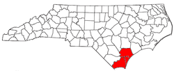
Three counties form the core of the Cape Fear region: New Hanover
New Hanover County, North Carolina
-Demographics:As of the census of 2000, there were 160,307 people, 68,183 households, and 41,591 families residing in the county. The population density was 806 people per square mile . There were 79,616 housing units at an average density of 400 per square mile...
, Brunswick
Brunswick County, North Carolina
-External links:*******....
, and Pender
Pender County, North Carolina
-Demographics:As of the census of 2000, there were 41,082 people, 16,054 households, and 11,719 families residing in the county. The population density was 47 people per square mile . There were 20,798 housing units at an average density of 24 per square mile...
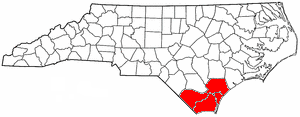
. These three counties are also included in the Wilmington Metropolitan Statistical Area, which as of the 2000 census
United States Census, 2000
The Twenty-second United States Census, known as Census 2000 and conducted by the Census Bureau, determined the resident population of the United States on April 1, 2000, to be 281,421,906, an increase of 13.2% over the 248,709,873 persons enumerated during the 1990 Census...
, had a population of 274,532. A July 1, 2008 census estimate puts the population total at 347,012. The coastal communities boast a large, seasonal tourism industry leading to much higher populations in the summer months and lower populations in the winter months.
Two additional counties, Bladen County
Bladen County, North Carolina
-Demographics:As of the census of 2000, there were 32,278 people, 12,897 households, and 8,937 families residing in the county. The population density was 37 people per square mile . There were 15,316 housing units at an average density of 18 per square mile...
and Columbus
Columbus County, North Carolina
-Demographics:As of the census of 2000, there were 54,749 people, 21,308 households, and 15,043 families residing in the county. The population density was 58/sq mi . As of 2004, there were 24,668 housing units at an average density of 26/sq mi...
, are occasionally included as part of the Cape Fear region, as are Duplin
Duplin County, North Carolina
-Demographics:As of the census of 2000, there were 49,063 people, 18,267 households, and 13,060 families residing in the county. The population density was 60 people per square mile . There were 20,520 housing units at an average density of 25 per square mile...
, Onslow
Onslow County, North Carolina
-Demographics:As of the census of 2000, there were 150,355 people, 48,122 households, and 36,572 families residing in the county. The population density was 196 people per square mile . There were 55,726 housing units at an average density of 73 per square mile...
, and Sampson
Sampson County, North Carolina
-Demographics:As of the census of 2010, there were 63,431 people, 22,624 households, and 16,214 families residing in the county. The population density was 67.1 people per square mile . There were 26,476 housing units at an average density of 27 per square mile...
counties, but to a lesser extent.
Geography
The Cape Fear region is situated on the Atlantic Coastal PlainAtlantic Coastal Plain
The Atlantic coastal plain has both low elevation and low relief, but it is also a relatively flat landform extending from the New York Bight southward to a Georgia/Florida section of the Eastern Continental Divide, which demarcates the plain from the ACF River Basin in the Gulf Coastal Plain to...
. A large portion of the region is low-lying wetlands, most notably the Green Swamp
Green Swamp (North Carolina)
The Green Swamp is a swamp that lies in Brunswick and Columbus counties in North Carolina. An unusual carnivorous plant known as the Venus Flytrap is found within this swamp. North Carolina laws prohibit the removal of these plants from their habitat....
, which is one of the rare habitats of the Venus Flytrap
Venus Flytrap
The Venus Flytrap , Dionaea muscipula, is a carnivorous plant that catches and digests animal prey—mostly insects and arachnids. Its trapping structure is formed by the terminal portion of each of the plant's leaves and is triggered by tiny hairs on their inner surfaces...
. The Cape Fear River
Cape Fear River
The Cape Fear River is a long blackwater river in east central North Carolina in the United States. It flows into the Atlantic Ocean near Cape Fear, from which it takes its name. The overall water quality of the river is continuously measured and monitored by and conducted by the , , and the...
and the Northeast Cape Fear River
Northeast Cape Fear River
The Northeast Cape Fear River is a blackwater river tributary of the Cape Fear River, approximately 130 mi long, in southeastern North Carolina in the United States....
are the deeper prominent rivers that flow through the region, with minor rivers like Lockwood Folly River
Lockwood Folly River
Lockwood Folly River or Lockwood's Folly River is a short tidal river in Brunswick County, North Carolina, USA. Waters from the Green Swamp drain into the river near Supply and flow southward to empty into the Atlantic Intracoastal Waterway near Sunset Harbor...
, Brunswick River
Brunswick River (North Carolina)
The Brunswick River in North Carolina runs for 14 miles along the west bank of Eagle Island near the city of Leland. The Brunswick River is a fork of the Cape Fear River; the river starts as an offshoot of the Cape Fear River at the town of Navassa and flows back into the Cape Fear River at the...
, and Shallotte River
Shallotte River
The Shallotte River is a tidal river in Brunswick County, North Carolina, USA. Waters drain from the tributaries of the Green Swamp near the town of Shallotte and flow south down the river to empty into the Atlantic Intracoastal Waterway....
providing access for small watercraft of small communities.
Cities
- WilmingtonWilmington, North CarolinaWilmington is a port city in and is the county seat of New Hanover County, North Carolina, United States. The population is 106,476 according to the 2010 Census, making it the eighth most populous city in the state of North Carolina...
(Principal city) - SouthportSouthport, North CarolinaSouthport is a city in Brunswick County, North Carolina, near the mouth of the Cape Fear River. It is part of the Wilmington Metropolitan Statistical Area...
- Boiling Spring LakesBoiling Spring Lakes, North CarolinaBoiling Spring Lakes is a city in Brunswick County, North Carolina, United States. The population was 2,972 at the 2000 census. It is part of the Wilmington Metropolitan Statistical Area.-Geography:Boiling Spring Lakes is located at ....
Towns
|
Ocean Isle Beach, North Carolina Ocean Isle Beach or simply Ocean Isle is a small seaside town located in Brunswick County, North Carolina, United States. The population was 426 at the 2000 census... Sandy Creek, North Carolina Sandy Creek is a town in Brunswick County, North Carolina, United States. The population was 246 at the 2000 census. It is part of the Wilmington Metropolitan Statistical Area.-Geography:Sandy Creek is located at .... Shallotte, North Carolina Shallotte is a town in Brunswick County, North Carolina, United States. The population was 1,381 at the 2000 census. It is part of the Wilmington Metropolitan Statistical Area... St. Helena, North Carolina St. Helena is a village in Pender County, North Carolina, United States. The population was 512 at the 2008 census. It is part of the Wilmington Metropolitan Statistical Area.-Geography:St... St. James, North Carolina St. James is a town in Brunswick County, North Carolina, United States. The population was 804 at the 2000 census. It is part of the Wilmington Metropolitan Statistical Area.-Geography:St... Sunset Beach, North Carolina Sunset Beach is a seaside town in Brunswick County, North Carolina, United States. The population was 1,824 at the 2000 census. It is part of the Wilmington Metropolitan Statistical Area.-Geography:Sunset Beach is located at .... Surf City, North Carolina Surf City is a town in Pender and Onslow counties in the U.S. state of North Carolina. The population was 2,057 at the 2008 census. It is located on Topsail Island.... (partial) Topsail Beach, North Carolina Topsail Beach is a town in Pender County, North Carolina, United States. The population was 581 at the 2008 census. It is part of the Wilmington Metropolitan Statistical Area.-Geography:Topsail Beach is located at .... Varnamtown, North Carolina Varnamtown is a town in Brunswick County, North Carolina, United States situated on the banks of the Lockwood Folly River. The population was 481 at the 2000 census... Wallace, North Carolina Wallace is a town in Duplin county in the U.S. state of North Carolina. The population was 3,344 at the 2000 census.The Pender County portion of Wallace is part of the Wilmington Metropolitan Statistical Area.-Geography:... (partial) Watha, North Carolina Watha is a town in Pender County, North Carolina, United States. The population was 151 at the 2000 census. It is part of the Wilmington Metropolitan Statistical Area.-Geography:Watha is located at .... Wrightsville Beach, North Carolina Wrightsville Beach is a town in New Hanover County, North Carolina, United States. Wrightsville Beach is just east of Wilmington and is part of the Wilmington Metropolitan Statistical Area. The population was 2,593 at the 2000 census... |
Former towns
- Brunswick TownBrunswick Town, North CarolinaBrunswick Town is a colonial ghost town located beside the Cape Fear River in Smithville Township, Brunswick County, North Carolina, United States. Brunswick Town was the first settlement in the Cape Fear region, a major North Carolina port in the 18th century, and home to three colonial governors...
- Long BeachLong Beach, North CarolinaLong Beach, North Carolina is a coastal neighborhood that is incorporated into Oak Island, North Carolina in the year of 1955. Located on Oak Island, it is well known for the total devastation it sustained during Hurricane Hazel in 1954; only five of the 357 buildings survived the storm...
- Yaupon BeachYaupon Beach, North CarolinaYaupon Beach, North Carolina is a coastal neighbourhood that is incorporated into the town of Oak Island in Brunswick County, North Carolina in the year of 1955. It has weathered many hurricanes, including Hazel in 1954 and Floyd in 1999. It merged with neighboring Long Beach in 1999 to form the...
Census-designated places
|
Myrtle Grove, North Carolina Myrtle Grove is a census-designated place in New Hanover County, North Carolina, United States. The population was 7,125 at the 2000 census... Ogden, North Carolina Ogden is a census-designated place in New Hanover County, North Carolina, United States. It is both a suburb of the city of Wilmington and part of the Wilmington Metropolitan Statistical Area... Sea Breeze, North Carolina Sea Breeze is a census-designated place in New Hanover County, North Carolina, United States. The population was 1,312 at the 2000 census... Seagate, North Carolina Seagate is a census-designated place in New Hanover County, North Carolina, United States. The population was 4,590 at the 2000 census. It is part of the Wilmington Metropolitan Statistical Area.-Geography:... Silver Lake, North Carolina Silver Lake is in New Hanover County, North Carolina, United States, and is a census-designated place . The population was 6,853 at the 2007 census... Skippers Corner, North Carolina Skippers Corner is a census-designated place in New Hanover County, North Carolina, United States. The population was 1,246 at the 2000 census... Wrightsboro, North Carolina Wrightsboro is a census-designated place in New Hanover County, North Carolina, in the United States. As of the 2007 census, the CDP population was 5,323... |
Unincorporated places
|
Sloop Point, North Carolina Sloop Point is an unincorporated community in Pender County, North Carolina, United States. It was an incorporated village, incorporated on July 1, 1996 and subsequently disincorporated on July 22, 1998, making it one of the shortest lived municipalities in the state's history, lasting just over... Supply, North Carolina Supply is a small unincorporated community in Brunswick County, North Carolina, USA located around the intersection of US 17 and NC 211 . Its name is derived from the use of the Lockwoods Folly River as a trade route in the 18th and 19th centuries... Winnabow, North Carolina Winnabow, North Carolina, is a place in Brunswick County in the U.S. states of North Carolina. It is located at It is mainly a farming community with ample farm land in the surrounding area. There are no big stores in the area except for a Hand Dee Hugo's at the intersection of NC 87 and US... Yamacraw, North Carolina Yamacraw is an unincorporated settlement in Pender County, North Carolina, United States.-In popular culture:Yamacraw is the birthplace of the character Philip Banks on the television series The Fresh Prince of Bel-Air.... |
Demographics
As of the censusCensus
A census is the procedure of systematically acquiring and recording information about the members of a given population. It is a regularly occurring and official count of a particular population. The term is used mostly in connection with national population and housing censuses; other common...
of 2000, there were 274,532 people, 114,675 households, and 75,347 families residing within the MSA. The racial makeup of the MSA was 79.47% White, 17.27% African American, 0.48% Native American, 0.58% Asian, 0.05% Pacific Islander, 1.12% from other races
Race (United States Census)
Race and ethnicity in the United States Census, as defined by the Federal Office of Management and Budget and the United States Census Bureau, are self-identification data items in which residents choose the race or races with which they most closely identify, and indicate whether or not they are...
, and 1.02% from two or more races. Hispanic or Latino of any race were 2.45% of the population.
The median income for a household in the MSA was $37,321, and the median income for a family was $44,844. Males had a median income of $32,454 versus $22,998 for females. The per capita income
Per capita income
Per capita income or income per person is a measure of mean income within an economic aggregate, such as a country or city. It is calculated by taking a measure of all sources of income in the aggregate and dividing it by the total population...
for the MSA was $20,287.
See also
- North Carolina census statistical areasNorth Carolina census statistical areasThe United States Census Bureau has defined 5 Combined Statistical Areas , 15 Metropolitan Statistical Areas , and 26 Micropolitan Statistical Areas in the State of North Carolina. The following table describes these areas with the following information:*The name of the Combined Statistical Area...
- Orton PlantationOrton PlantationThe Orton Plantation is a historic Southern plantation in the Smithville Township of Brunswick County, North Carolina, United States. Located beside the Cape Fear River between Wilmington and Southport, Orton Plantation is considered to be a near-perfect example of Southern antebellum architecture...
- St. Philip's Church RuinsSt. Philip's Church RuinsThe St. Philip's Church Ruins are the remains of a colonial Anglican church building in Brunswick Town, North Carolina, United States. The church is located beside the Cape Fear River in the Brunswick Town Historic District, along with Fort Anderson, Russelborough and the nearby Orton Plantation....