
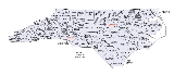
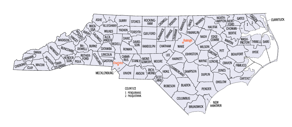
North Carolina census statistical areas
Encyclopedia
The United States Census Bureau
has defined 5 Combined Statistical Area
s (CSAs), 15 Metropolitan Statistical Areas (MSAs), and 26 Micropolitan Statistical Areas (μSAs) in the State of North Carolina. The following table describes these areas with the following information:
United States Census Bureau
The United States Census Bureau is the government agency that is responsible for the United States Census. It also gathers other national demographic and economic data...
has defined 5 Combined Statistical Area
Combined Statistical Area
The United States Office of Management and Budget defines micropolitan and metropolitan statistical areas. Metropolitan and micropolitan statistical areas consist of one or more counties...
s (CSAs), 15 Metropolitan Statistical Areas (MSAs), and 26 Micropolitan Statistical Areas (μSAs) in the State of North Carolina. The following table describes these areas with the following information:
- The name of the Combined Statistical Area (CSA).
- The population of the CSA as of 2009-07-01, as estimated by the United States Census Bureau.
- The name of the Core Based Statistical AreaCore based statistical areaA Core Based Statistical Area is a U.S. geographic area defined by the Office of Management and Budget based around an urban center of at least 10,000 people and adjacent areas that are socioeconomically tied to the urban center by commuting. Areas defined on the basis of these standards applied...
(CBSA). - The population of the CBSA as of 2009-07-01, as estimated by the United States Census Bureau.
- The name of the countyCounty (United States)In the United States, a county is a geographic subdivision of a state , usually assigned some governmental authority. The term "county" is used in 48 of the 50 states; Louisiana is divided into parishes and Alaska into boroughs. Parishes and boroughs are called "county-equivalents" by the U.S...
or independent cityIndependent cityAn independent city is a city that does not form part of another general-purpose local government entity. These type of cities should not be confused with city-states , which are fully sovereign cities that are not part of any other sovereign state.-Historical precursors:In the Holy Roman Empire,...
. - The population of the county or independent city as of 2009-07-01, as estimated by the United States Census Bureau.
| Combined Statistical Area | 2009 Pop | Core Based Statistical Area | 2009 Pop | County | 2009 Pop |
|---|---|---|---|---|---|
| Charlotte-Gastonia-Salisbury, NC-SC CSA | 2,389,763 | Charlotte-Gastonia-Concord, NC-SC MSA | 1,745,524 | Mecklenburg County, North Carolina Mecklenburg County, North Carolina -Air:The county's primary commercial aviation airport is Charlotte Douglas International Airport in Charlotte.- Intercity rail :With twenty-five freight trains a day, Mecklenburg is a freight railroad transportation center, largely due to its place on the NS main line between Washington and Atlanta... |
913,639 |
| Gaston County, North Carolina Gaston County, North Carolina Gaston County is a county located just west of Charlotte in the southern Piedmont in the U.S. state of North Carolina. It is the third largest county, by population, in the Charlotte Metropolitan Area, officially designated the Charlotte-Gastonia-Concord Metropolitan Statistical Area . As of... |
208,958 | ||||
| York County, South Carolina York County, South Carolina York County is a county located in the north-central section of the U.S. state of South Carolina. According to the 2010 census, the county's population was 226,073. It is the second largest county in the Charlotte metropolitan area... |
227,003 | ||||
| Union County, North Carolina Union County, North Carolina -Demographics:As of the census of 2000, there were 123,677 people, 43,390 households, and 34,278 families residing in the county. The population density was 194 people per square mile . There were 45,695 housing units at an average density of 72 per square mile... |
198,645 | ||||
| Cabarrus County, North Carolina Cabarrus County, North Carolina -Demographics:As of the census of 2000, there were 131,063 people, 49,519 households, and 36,545 families residing in the county. The population density was 360 people per square mile . There were 52,848 housing units at an average density of 145 per square mile... |
172,223 | ||||
| Anson County, North Carolina Anson County, North Carolina -See also:*National Register of Historic Places listings in Anson County, North Carolina-External links:*... |
25,056 | ||||
| Statesville-Mooresville, NC μSA | 158,153 | Iredell County, North Carolina Iredell County, North Carolina Iredell County, along with Moore County in the eastern Piedmont, are among a very few counties in the United States sharing borders with nine adjacent counties.-Demographics:... |
158,153 | ||
| Salisbury, NC μSA | 140,798 | Rowan County, North Carolina Rowan County, North Carolina -Demographics and economics:As of the census of 2010, there were 138,428 people, 53,140 households, and 37,058 families residing in the county. The population density was 270.7 people per square mile . There were 60,211 housing units at an average density of 117.7 per square mile... |
140,798 | ||
| Shelby, NC μSA | 99,274 | Cleveland County, North Carolina Cleveland County, North Carolina -Demographics:As of the census of 2010, there were 98,078 people, 37,046 households, and 27,006 families residing in the county. The population density was 207 people per square mile . There were 40,317 housing units at an average density of 87 per square mile... |
99,274 | ||
| Lincolnton, NC μSA | 76,043 | Lincoln County, North Carolina Lincoln County, North Carolina -Demographics:As of the census of 2010, there were 71,498 people, 24,041 households, and 18,174 families residing in the county. The population density was 214 people per square mile . There were 25,717 housing units at an average density of 86 per square mile... |
76,043 | ||
| Lancaster, SC μSA | 77,767 | Lancaster County, South Carolina | 77,767 | ||
| Albemarle, NC μSA | 59,794 | Stanly County, North Carolina Stanly County, North Carolina -Demographics:As of the census of 2010, there were 60,585 people. In 2000 there were 22,223 households, and 16,156 families residing in the county. The population density was 147 people per square mile . There were 24,582 housing units at an average density of 62 per square mile... |
59,794 | ||
| Chester, SC μSA | 32,410 | Chester County, South Carolina Chester County, South Carolina Chester County is a county located in the U.S. state of South Carolina. In 2000, its population was 34,068; in 2005 the U.S. Census Bureau estimated that its population had dropped to 33,228. Its county seat is Chester.-Geography and climate:... |
32,410 | ||
| Raleigh-Durham-Cary, NC CSA | 1,742,816 | Raleigh-Cary, NC MSA | 1,125,827 | Wake County, North Carolina Wake County, North Carolina Wake County is a county located in the U.S. state of North Carolina. As of the 2010 census, the population was 900,993 making it North Carolina's second most populated county... |
897,214 |
| Johnston County, North Carolina Johnston County, North Carolina -Major highways:* Interstate 40* Interstate 95* U.S. Highway 70* U.S. Highway 301* U.S. Highway 701-Demographics:As of the census of 2000, there were 121,965 people, 46,595 households, and 33,688 families residing in the county. The population density was 154 people per square mile . There were... |
168,525 | ||||
| Franklin County, North Carolina Franklin County, North Carolina -Demographics:As of the census of 2000, there were 47,260 people, 17,843 households, and 12,882 families residing in the county. The population density was 96 people per square mile . There were 20,364 housing units at an average density of 41 per square mile... |
60,088 | ||||
| Durham, NC MSA | 501,228 | Durham County, North Carolina Durham County, North Carolina -Demographics:As of the census of 2000, there were 223,314 people, 89,015 households, and 54,032 families residing in the county. The population density was 769 people per square mile . There were 95,452 housing units at an average density of 329 per square mile... |
269,706 | ||
| Orange County, North Carolina Orange County, North Carolina Orange County is a county located in the U.S. state of North Carolina. As of the 2010 census, the population was 133,801. Its county seat is Hillsborough... |
129,083 | ||||
| Chatham County, North Carolina Chatham County, North Carolina Chatham County is a county located in the Piedmont area of the U.S. state of North Carolina. As of 2000, the population was 49,329. Its county seat is Pittsboro.-History:... |
64,772 | ||||
| Person County, North Carolina Person County, North Carolina Person County is a county located in the Piedmont region in north-central North Carolina in the United States. It is part of the Durham-Chapel Hill Metropolitan Area. The population was 39,464 at the 2010 census.The county seat is Roxboro... |
37,667 | ||||
| Dunn, NC μSA | 115,761 | Harnett County, North Carolina Harnett County, North Carolina -Demographics:As of the census of 2000, there were 91,025 people, 33,800 households, and 24,099 families residing in the county. The population density was 153 people per square mile . There were 38,605 housing units at an average density of 65 per square mile... |
115,761 | ||
| Greensboro-Winston-Salem-High Point, NC CSA | 1,581,122 | Greensboro-High Point, NC MSA | 714,765 | Guilford County, North Carolina Guilford County, North Carolina Guilford County is a county located in the U.S. state of North Carolina. In 2010, the Census Bureau estimated the county's population to be 491,230. Its seat is Greensboro. Since 1938, an additional county court has been located in High Point, North Carolina, making Guilford one of only a handful... |
480,362 |
| Randolph County, North Carolina Randolph County, North Carolina -Notable people:*Naomi Wise, murder victim*Richard Petty - Nascar driver.*Lee Petty - Nascar pioneer. Richard Petty's father.*Kyle Petty - Nascar driver. Son of Richard Petty*Adam Petty - Nascar driver. Kyle Petty's son... |
142,151 | ||||
| Rockingham County, North Carolina Rockingham County, North Carolina Rockingham County is a county located in the U.S. state of North Carolina. As of 2010, the population was 93,643. Its county seat is Wentworth.- History :The county was formed in 1785 from Guilford County... |
92,252 | ||||
| Winston-Salem, NC MSA | 484,921 | Forsyth County, North Carolina Forsyth County, North Carolina -Demographics:As of the census of 2000, there were 306,067 people, 123,851 households, and 81,741 families residing in the county. The population density was 747 people per square mile . There were 133,093 housing units at an average density of 325 per square mile... |
359,638 | ||
| Stokes County, North Carolina Stokes County, North Carolina -Demographics:As of the census of 2000, there were 44,711 people, 17,579 households, and 13,043 families residing in the county. The population density was 99 people per square mile . There were 19,262 housing units at an average density of 43 per square mile... |
46,150 | ||||
| Davie County, North Carolina Davie County, North Carolina - Wine region :Portions of Davie County are located in the Yadkin Valley AVA, an American Viticultural Area. Wines made from grapes grown in the Yadkin Valley AVA may use the appellation Yadkin Valley on their labels.-Demographics:... |
41,420 | ||||
| Yadkin County, North Carolina Yadkin County, North Carolina - Cities and towns :*Boonville*East Bend*Jonesville*Yadkinville-Towns of the past:These towns were incorporated at one time:*Arlington, merged with Jonesville in 2001.*Hamptonville, chartered in 1818.*Huntsville, incorporated in 1792.... |
37,713 | ||||
| Thomasville-Lexington, NC μSA | 158,582 | Davidson County, North Carolina Davidson County, North Carolina -Demographics:As of the census of 2010, there were 149,331 people, 58,156 households, and 42,512 families residing in the county. The population density was 267 people per square mile . There were 62,432 housing units at an average density of 113 per square mile... |
158,582 | ||
| Burlington, NC MSA | 150,358 | Alamance County, North Carolina Alamance County, North Carolina Alamance County is a county located in the U.S. state of North Carolina. It coincides with the Burlington, North Carolina, Metropolitan Statistical Area... |
150,358 | ||
| Mount Airy, NC μSA | 72,496 | Surry County, North Carolina Surry County, North Carolina Surry County is a county located in the U.S. state of North Carolina. As of 2010, the population was 73,673. Its county seat is Dobson.- History :The county was formed in 1771 from Rowan County... |
72,496 | ||
| Asheville-Brevard, NC CSA | 427,789 | Asheville, NC MSA | 412,672 | Buncombe County, North Carolina Buncombe County, North Carolina -Demographics:As of the census of 2000, there were 206,330 people, 85,776 households, and 55,668 families residing in the county. The population density was 314 people per square mile . There were 93,973 housing units at an average density of 143 per square mile... |
231,452 |
| Henderson County, North Carolina Henderson County, North Carolina Henderson County is a county located in the U.S. state of North Carolina. It is part of the Asheville, North Carolina, Metropolitan Statistical Area. As of 2008, the population was 102,367. Its county seat is Hendersonville.- History :... |
103,669 | ||||
| Haywood County, North Carolina Haywood County, North Carolina -National protected areas:* Blue Ridge Parkway * Great Smoky Mountains National Park * Pisgah National Forest -Major Highways & Roads:* Interstate 40* U.S. Highway 19* U.S. Highway 23* U.S. Highway 74* U.S... |
57,109 | ||||
| Madison County, North Carolina Madison County, North Carolina -Demographics:As of the census of 2000, there were 19,635 people, 8,000 households, and 5,592 families residing in the county. The population density was 44 people per square mile . There were 9,722 housing units at an average density of 22 per square mile... |
20,442 | ||||
| Brevard, NC μSA | 30,203 | Transylvania County, North Carolina Transylvania County, North Carolina Transylvania County is a county located in the U.S. state of North Carolina. As of 2010, the population was 33,090. Its county seat is Brevard.- History :The county was formed in 1861 from parts of Henderson County and Jackson County... |
30,203 | ||
| primary census statistical area | 365,364 | Hickory-Lenoir-Morganton, NC MSA | 365,364 | Catawba County, North Carolina Catawba County, North Carolina -Demographics:As of the census of 2010, there were 160,000 people, 55,533 households, and 39,095 families residing in the county. The population density was 354 people per square mile . There were 59,919 housing units at an average density of 150 per square mile... |
159,125 |
| Burke County, North Carolina Burke County, North Carolina -Demographics:As of the census of 2000, there were 89,148 people, 34,528 households, and 24,342 families residing in the county. The population density was 176 people per square mile . There were 37,427 housing units at an average density of 74 per square mile... |
89,548 | ||||
| Caldwell County, North Carolina Caldwell County, North Carolina -Demographics:As of the census of 2000, there were 77,415 people, 30,768 households, and 22,399 families residing in the county. The population density was 164 people per square mile . There were 33,430 housing units at an average density of 71 per square mile... |
79,914 | ||||
| Alexander County, North Carolina Alexander County, North Carolina -Demographics:As of the census of 2000, there were 33,603 people, 13,137 households, and 9,747 families residing in the county. The population density was 129 people per square mile . There were 14,098 housing units at an average density of 54 per square mile... |
36,777 | ||||
| primary census statistical area | 360,355 | Fayetteville, NC MSA | 360,355 | Cumberland County, North Carolina Cumberland County, North Carolina -Demographics:As of the census of 2000, there were 302,963 people, 107,358 households, and 77,619 families residing in the county. The population density was 464 people per square mile . There were 118,425 housing units at an average density of 181 per square mile... |
315,207 |
| Hoke County, North Carolina Hoke County, North Carolina -Demographics:As of the census of 2010, there were 46,952 people, 11,373 households, and 8,745 families residing in the county. The population density was 86 people per square mile . There were 12,518 housing units at an average density of 32 per square mile... |
45,148 | ||||
| primary census statistical area | 354,525 | Wilmington, NC MSA | 354,525 | New Hanover County, North Carolina New Hanover County, North Carolina -Demographics:As of the census of 2000, there were 160,307 people, 68,183 households, and 41,591 families residing in the county. The population density was 806 people per square mile . There were 79,616 housing units at an average density of 400 per square mile... |
195,085 |
| Brunswick County, North Carolina Brunswick County, North Carolina -External links:*******.... |
107,062 | ||||
| Pender County, North Carolina Pender County, North Carolina -Demographics:As of the census of 2000, there were 41,082 people, 16,054 households, and 11,719 families residing in the county. The population density was 47 people per square mile . There were 20,798 housing units at an average density of 24 per square mile... |
52,378 | ||||
| Lumberton-Laurinburg, NC CSA | 166,115 | Lumberton, NC μSA | 129,559 | Robeson County, North Carolina Robeson County, North Carolina Robeson County is a county in the U.S. state of North Carolina. As of 2010 it had a population of 134,168. Since then, it has been one of the 10% of United States counties that were majority-minority; its combined population of American Indian, African American and Latino residents comprise over... |
129,559 |
| Laurinburg, NC μSA | 36,292 | Scotland County, North Carolina Scotland County, North Carolina -Demographics:As of the census of 2000, there were 35,998 people, 13,399 households, and 9,674 families residing in the county. The population density was 113 people per square mile . There were 14,693 housing units at an average density of 46 per square mile... |
36,292 | ||
| primary census statistical area | 179,715 | Greenville, NC MSA | 179,715 | Pitt County, North Carolina Pitt County, North Carolina -Demographics:As of the census of 2000, there were 133,798 people, 52,539 households, and 32,258 families residing in the county. The population density was 205 people per square mile . There were 58,408 housing units at an average density of 90 per square mile... |
159,057 |
| Greene County, North Carolina Greene County, North Carolina -Demographics:As of the census of 2000, there were 18,974 people, 6,696 households, and 4,955 families residing in the county. The population density was 72 people per square mile . There were 7,368 housing units at an average density of 28 per square mile... |
20,658 | ||||
| primary census statistical area | 150,673 | Jacksonville, NC MSA | 173,064 | Onslow County, North Carolina Onslow County, North Carolina -Demographics:As of the census of 2000, there were 150,355 people, 48,122 households, and 36,572 families residing in the county. The population density was 196 people per square mile . There were 55,726 housing units at an average density of 73 per square mile... |
173,064 |
| primary census statistical area | 146,596 | Rocky Mount, NC MSA | 146,596 | Nash County, North Carolina Nash County, North Carolina Nash County is a county located in the U.S. state of North Carolina. It is part of the Rocky Mount, North Carolina, Metropolitan Statistical Area. As of 2000, the population was 87,420. Its county seat is Nashville.- History :... |
94,743 |
| Edgecombe County, North Carolina Edgecombe County, North Carolina -Demographics:As of the census of 2000, there were 55,606 people, 20,392 households, and 14,804 families residing in the county. The population density was 110 people per square mile . There were 24,002 housing units at an average density of 48 per square mile... |
51,853 | ||||
| primary census statistical area | 121,022 | New Bern, NC μSA | 121,022 | Craven County, North Carolina Craven County, North Carolina Craven County is a county located in the U.S. state of North Carolina. The estimated population in 2006 was 94,875. Its county seat is New Bern.Craven County is part of the New Bern, North Carolina, Micropolitan Statistical Area.-History:... |
98,529 |
| Pamlico County, North Carolina Pamlico County, North Carolina -Demographics:As of the census of 2000, there were 12,934 people, 5,178 households, and 3,717 families residing in the county. The population density was 38 people per square mile . There were 6,781 housing units at an average density of 20 per square mile... |
12,422 | ||||
| Jones County, North Carolina Jones County, North Carolina -Demographics:As of the census of 2000, there were 10,381 people, 4,061 households, and 2,936 families residing in the county. The population density was 22 people per square mile . There were 4,679 housing units at an average density of 10 per square mile... |
10,071 | ||||
| primary census statistical area | 113,847 | Goldsboro, NC MSA | 113,811 | Wayne County, North Carolina Wayne County, North Carolina - Cities and towns :*Brogden*Dudley*Elroy*Eureka*Fremont*Goldsboro*Mar-Mac*Mount Olive*Pikeville*Rosewood*Seven Springs*Walnut Creek*Grantham-Geography:According to the U.S... |
113,811 |
| primary census statistical area | 83,162 | Southern Pines-Pinehurst, NC μSA | 83,162 | Moore County, North Carolina Moore County, North Carolina Moore County is a county located in the U.S. state of North Carolina. As of 2000, the population was 74,769. Its county seat is Carthage.- History :The county was formed in 1784 from Cumberland County... |
87,158 |
| primary census statistical area | 74,718 | Roanoke Rapids, NC μSA | 74,718 | Halifax County, North Carolina Halifax County, North Carolina -Demographics:-Demographics:-Demographics:-Demographics:-Demographics:-Demographics:-Demographics:-Demographics:-Demographics:[[Image:HalifaxCountyCotton.wmg.jpg|left|thumb|A cotton field blooms in Halifax County.... |
54,582 |
| Northampton County, North Carolina Northampton County, North Carolina -Demographics:As of the census of 2000, there were 22,086 people, 8,691 households, and 5,953 families residing in the county. The population density was 41 people per square mile . There were 10,455 housing units at an average density of 20 per square mile... |
20,136 | ||||
| primary census statistical area | 76,624 | Wilson, NC μSA | 78,353 | Wilson County, North Carolina Wilson County, North Carolina -Demographics:As of the census of 2006, there 73,814 people, 28,613 households, and 19,771 families residing in the county. The population density was 199 people per square mile . There were 30,729 housing units at an average density of 83 per square mile... |
78,353 |
| primary census statistical area | 66,555 | North Wilkesboro, NC μSA | 66,555 | Wilkes County, North Carolina Wilkes County, North Carolina Wilkes County is a county located in the U.S. state of North Carolina. The 2000 U.S. Census listed the county's population at 65,632; the 2010 U.S. Census listed the population at 69,340... |
66,555 |
| primary census statistical area | 63,415 | Forest City, NC μSA | 63,415 | Rutherford County, North Carolina Rutherford County, North Carolina -Demographics:As of the census of 2000, there were 62,899 people, 25,191 households, and 17,935 families residing in the county. The population density was 112 people per square mile . There were 29,535 housing units at an average density of 52 per square mile... |
63,415 |
| primary census statistical area | 64,423 | Morehead City, NC μSA | 64,423 | Carteret County, North Carolina Carteret County, North Carolina Carteret County is a county located in the U.S. state of North Carolina. As of 2010, the population was 66,469. Its county seat is Beaufort. Most of the county is part of the Crystal Coast.... |
64,423 |
| primary census statistical area | 64,042 | Elizabeth City, NC μSA | 64,042 | Pasquotank County, North Carolina Pasquotank County, North Carolina -Demographics:As of the census of 2010, there were 40,661 people, 13,907 households, and 9,687 families residing in the county. The population density was 154 people per square mile . There were 14,289 housing units at an average density of 63 per square mile... |
41,578 |
| Perquimans County, North Carolina Perquimans County, North Carolina -Demographics:As of the census of 2010, there were 13,453 people, 4,645 households, and 3,376 families residing in the county. The population density was 46 people per square mile . There were 6,043 housing units at an average density of 24 per square mile... |
12,734 | ||||
| Camden County, North Carolina Camden County, North Carolina -Schools:There are five schools in Camden County: Grandy Primary School, Camden Intermediate School, Camden Middle School, Camden County High School, and CamTech High School. However one other former school lies in Shiloh. It was a community school for the Shiloh area. The school is now home to a... |
9,730 | ||||
| primary census statistical area | 57,662 | Kinston, NC μSA | 56,387 | Lenoir County, North Carolina Lenoir County, North Carolina -Demographics:As of 2005, there were 57,961 people, 23,862 households, and 16,178 families residing in the county. The population density was 149.2 people per square mile . There were 27,940 housing units at an average density of 68 per square mile... |
56,387 |
| primary census statistical area | 60,477 | Sanford, NC μSA | 60,477 | Lee County, North Carolina Lee County, North Carolina -Demographics:As of the census of 2000, there were 49,040 people, 18,466 households, and 13,369 families residing in the county. The population density was 191 people per square mile . There were 19,909 housing units at an average density of 77 per square mile... |
60,477 |
| primary census statistical area | 45,970 | Rockingham, NC μSA | 45,970 | Richmond County, North Carolina Richmond County, North Carolina -Demographics:As of the census of 2000, there were 46,564 people, 17,873 households, and 12,582 families residing in the county. The population density was 98 people per square mile . There were 19,886 housing units at an average density of 42 per square mile... |
45,970 |
| primary census statistical area | 46,414 | Washington, NC μSA | 46,414 | Beaufort County, North Carolina Beaufort County, North Carolina - Law and government :Beaufort County is a member of the Mid-East Commission regional council of governments.Beaufort County is one of the proposed sites for a Navy outlying landing field. This practice airfield would allow pilots to simulate landings on an aircraft carrier... |
46,414 |
| primary census statistical area | 43,056 | Henderson, NC μSA | 43,056 | Vance County, North Carolina Vance County, North Carolina -Demographics:As of the census of 2000, there were 42,954 people, 16,199 households, and 11,647 families residing in the county. The population density was 169 people per square mile . There were 18,196 housing units at an average density of 72 per square mile... |
43,056 |
| primary census statistical area | 45,479 | Boone, NC μSA | 45,479 | Watauga County, North Carolina Watauga County, North Carolina -Demographics:As of the census of 2000, there were 42,695 people, 16,540 households, and 9,411 families residing in the county. The population density was 137 people per square mile . There were 23,155 housing units at an average density of 74 per square mile... |
45,479 |
| primary census statistical area | 34,296 | Kill Devil Hills, NC μSA | 34,296 | Dare County, North Carolina Dare County, North Carolina -National protected areas:* Alligator River National Wildlife Refuge * Cape Hatteras National Seashore * Fort Raleigh National Historic Site* Pea Island National Wildlife Refuge* Wright Brothers National Memorial-Demographics:... |
34,296 |
| primary census statistical area | 1,676,542 24,216 |
Virginia Beach-Norfolk-Newport News, VA-NC MSA | 1,676,542 24,216 |
City of Virginia Beach, Virginia | 435,619 |
| City of Norfolk, Virginia | 233,333 | ||||
| City of Chesapeake, Virginia | 222,455 | ||||
| City of Newport News, Virginia | 193,172 | ||||
| City of Hampton, Virginia | 144,236 | ||||
| City of Portsmouth, Virginia | 99,321 | ||||
| City of Suffolk, Virginia | 83,659 | ||||
| York County, Virginia York County, Virginia York County is a county located on the north side of the Virginia Peninsula in the Hampton Roads metropolitan area of the Commonwealth of Virginia, a state of the United States. Situated on the York River and many tributaries, the county seat is the unincorporated town of Yorktown... |
61,140 | ||||
| James City County, Virginia James City County, Virginia James City County is a county located on the Virginia Peninsula in the Hampton Roads metropolitan area of the Commonwealth of Virginia, a state of the United States. Its population was 67,009 , and it is often associated with Williamsburg, an independent city, and Jamestown which is within the... |
63,735 | ||||
| Gloucester County, Virginia Gloucester County, Virginia Gloucester County is within the Commonwealth of Virginia in the Hampton Roads metropolitan area in the USA. Formed in 1651 in the Virginia Colony, the county was named for Henry Stuart, Duke of Gloucester, third son of King Charles I of Great Britain. Located in the Middle Peninsula region, it... |
39,184 | ||||
| Isle of Wight County, Virginia Isle of Wight County, Virginia As of the census of 2010, there were 35,270 people, 11,319 households, and 8,670 families residing in the county. The population density was 94 people per square mile . There were 12,066 housing units at an average density of 38 per square mile... |
35,877 | ||||
| Currituck County, North Carolina Currituck County, North Carolina -National protected areas:*Currituck National Wildlife Refuge*Mackay Island National Wildlife Refuge -Demographics:As of the census of 2010, there were 23,547 people, 6,902 households, and 5,204 families residing in the county. The population density was 70 people per square mile . There were... |
24,216 | ||||
| City of Poquoson, Virginia | 11,794 | ||||
| City of Williamsburg, Virginia | 12,729 | ||||
| Mathews County, Virginia Mathews County, Virginia As of the census of 2010, there were 8,978 people, 3,932 households, and 2,823 families residing in the county. The population density was 108 people per square mile . There were 5,333 housing units at an average density of 62 per square mile... |
8,984 | ||||
| Surry County, Virginia Surry County, Virginia As of the census of 2010, there were 7,058 people, 2,619 households, and 1,917 families residing in the county. The population density was 24 people per square mile . There were 3,294 housing units at an average density of 12 per square mile... |
7,088 | ||||
| none | Sampson County, North Carolina Sampson County, North Carolina -Demographics:As of the census of 2010, there were 63,431 people, 22,624 households, and 16,214 families residing in the county. The population density was 67.1 people per square mile . There were 26,476 housing units at an average density of 27 per square mile... |
63,713 | |||
| Columbus County, North Carolina Columbus County, North Carolina -Demographics:As of the census of 2000, there were 54,749 people, 21,308 households, and 15,043 families residing in the county. The population density was 58/sq mi . As of 2004, there were 24,668 housing units at an average density of 26/sq mi... |
54,221 | ||||
| Granville County, North Carolina Granville County, North Carolina -Demographics:As of the census of 2010, there were 59,916 people in 20,628 households residing in the county. The population density was 111.6 people per square mile . There were 22,827 housing units at an average density of 42.5 per square mile... |
57,639 | ||||
| Duplin County, North Carolina Duplin County, North Carolina -Demographics:As of the census of 2000, there were 49,063 people, 18,267 households, and 13,060 families residing in the county. The population density was 60 people per square mile . There were 20,520 housing units at an average density of 25 per square mile... |
53,177 | ||||
| McDowell County, North Carolina McDowell County, North Carolina -Cities and towns:*Marion *Old Fort-Unincorporated places:*West Marion*Little Switzerland*Nebo*Glenwood*Pleasant Gardens*North Cove-Education:The following is a list of schools located in McDowell County:*Marion Elementary School... |
43,988 | ||||
| Jackson County, North Carolina Jackson County, North Carolina Jackson County is a county located in the southwest of the U.S. state of North Carolina. As of 2010, the population was 40,271. Since 1913 its county seat has been Sylva, replacing Webster.-History:... |
36,891 | ||||
| Bladen County, North Carolina Bladen County, North Carolina -Demographics:As of the census of 2000, there were 32,278 people, 12,897 households, and 8,937 families residing in the county. The population density was 37 people per square mile . There were 15,316 housing units at an average density of 18 per square mile... |
32,343 | ||||
| Macon County, North Carolina Macon County, North Carolina - Geographic features :Of the in Macon County, are federal lands that lie within the Nantahala National Forest and are administered by the United States Forest Service. Of the of USFS land, lie in the Highlands Ranger District and the remaining lie in the Wayah Ranger District... |
33,233 | ||||
| Montgomery County, North Carolina Montgomery County, North Carolina -Demographics:As of the census of 2000, there were 26,822 people, 9,848 households, and 7,189 families residing in the county. The population density was 55 people per square mile . There were 14,145 housing units at an average density of 29 per square mile... |
27,745 | ||||
| Cherokee County, North Carolina Cherokee County, North Carolina - Transportation :Cherokee County is well known in North Carolina as the westernmost of the state's 100 counties. Several US and state highways serve the county, linking it with other regions of North Carolina, along with the neighboring states of Georgia and Tennessee.US 64 - the longest highway... |
26,307 | ||||
| Ashe County, North Carolina Ashe County, North Carolina - History :Historical evidence shows that Ashe county was inhabited by Native Americans, which included the Cherokee, Creek, and Shawnee tribes. Pieces of broken pottery, arrowheads, and other Native American artifacts have been found, indicating their presence... |
25,812 | ||||
| Martin County, North Carolina Martin County, North Carolina -Politics:Martin County has tended to vote in line with the rest of the country in presidential elections. In 2008, Barack Obama won the county with 52.2% of the vote. This was very similar to his national figure of 52.91%.-Demographics:... |
23,337 | ||||
| Hertford County, North Carolina Hertford County, North Carolina -Townships:The county is divided into six townships:Ahoskie, Como, Harrellsville, Murfreesboro, St. Johns and Winton.-Towns:*Ahoskie*Cofield*Como*Harrellsville*Murfreesboro*Winton-Demographics:... |
23,283 | ||||
| Caswell County, North Carolina Caswell County, North Carolina -Demographics:As of the census of 2000, there were 23,501 people, 8,670 households, and 6,398 families residing in the county. The population density was 55 people per square mile . There were 9,601 housing units at an average density of 23 per square mile... |
23,004 | ||||
| Warren County, North Carolina Warren County, North Carolina -Demographics:As of the census of 2000, there were 19,972 people, 7,708 households, and 5,449 families residing in the county. The population density was 47 people per square mile . There were 10,548 housing units at an average density of 25 per square mile... |
19,425 | ||||
| Polk County, North Carolina Polk County, North Carolina Polk County is a county located in the U.S. state of North Carolina. As of 2010, the population was 20,510. Its county seat is Columbus.-History:The county was formed in 1855 from parts of Henderson County and Rutherford County... |
19,255 | ||||
| Bertie County, North Carolina Bertie County, North Carolina -External links:**... |
19,345 | ||||
| Yancey County, North Carolina Yancey County, North Carolina -Demographics:As of the census of 2000, there were 17,774 people, 7,472 households, and 5,372 families residing in the county. The population density was 57 people per square mile . There were 9,729 housing units at an average density of 31 per square mile... |
18,548 | ||||
| Avery County, North Carolina Avery County, North Carolina - Climate :As a result of its relatively high elevation, Avery County has a Humid continental climate enjoying considerably cooler summers than most of the rest of the Eastern US. Likewise, winters are longer, colder and snowier than most other locations in the region. This can be evidenced by the... |
17,932 | ||||
| Mitchell County, North Carolina Mitchell County, North Carolina -National protected areas:* Blue Ridge Parkway * Pisgah National Forest -Demographics:As of the census of 2000, there were 15,687 people, 6,551 households, and 4,736 families residing in the county. The population density was 71 people per square mile . There were 7,919 housing units at an... |
15,634 | ||||
| Chowan County, North Carolina Chowan County, North Carolina - Law and government :Chowan County is a member of the Albemarle Commission regional council of government-Demographics:As of the census of 2010, there were 14,793 people, 5,580 households, and 4,006 families residing in the county. The population density was 84 people per square mile . There... |
14,784 | ||||
| Swain County, North Carolina Swain County, North Carolina Swain County is a county located in the U.S. state of North Carolina. As of 2000, the population was 12,968. Its county seat is Bryson City.Swain County is home of the Nantahala River . The Nantahala is one of the most popular whitewater rafting rivers in the nation... |
13,404 | ||||
| Washington County, North Carolina Washington County, North Carolina -Demographics:As of the census of 2000, there were 13,723 people, 5,367 households, and 3,907 families residing in the county. The population density was 39 people per square mile . There were 6,174 housing units at an average density of 18 per square mile... |
12,851 | ||||
| Gates County, North Carolina Gates County, North Carolina Gates County is a small rural county located in the U.S. state of North Carolina. As of 2010, the population was 12,197. Its county seat is Gatesville. It is part of the Albemarle Sound area of the Inner Banks... |
11,768 | ||||
| Alleghany County, North Carolina Alleghany County, North Carolina -Major highways:* U.S. Highway 21* U.S. Highway 221* North Carolina Highway 18* North Carolina Highway 88* North Carolina Highway 93* North Carolina Highway 113-Demographics:... |
10,964 | ||||
| Clay County, North Carolina Clay County, North Carolina -Communities and Townships:Hayesville, with a 2000 population of 297, is the only incorporated town in the county, the county seat, and center of economic activity for Clay County... |
10,333 | ||||
| Graham County, North Carolina Graham County, North Carolina -Demographics:As of the census of 2000, there were 7,993 people, 3,354 households, and 2,411 families residing in the county. The population density was 27 people per square mile . There were 5,084 housing units at an average density of 17 per square mile... |
8,001 | ||||
| Hyde County, North Carolina Hyde County, North Carolina -National protected areas:* Alligator River National Wildlife Refuge * Cape Hatteras National Seashore * Mattamuskeet National Wildlife Refuge* Pocosin Lakes National Wildlife Refuge * Swanquarter National Wildlife Refuge-Demographics:... |
5,211 | ||||
| Tyrrell County, North Carolina Tyrrell County, North Carolina -Demographics:Tyrrell County was as of 2000 the least populous county in North Carolina.As of the census of 2000, there were 4,149 people, 1,537 households, and 1,055 families residing in the county. The population density was 11 people per square mile . There were 2,032 housing units at an... |
4,078 | ||||
See also
- State of North Carolina
- Demographics of North CarolinaDemographics of North CarolinaDemographics of North Carolina covers the varieties of ethinic groups and relevant trends that reside in North Carolina, along with the relevant trends.-Center of population:Center of Population in between Seagrove and Cheeks, North Carolina...
- Geography of North CarolinaGeography of North CarolinaThe Geography of North Carolina falls naturally into three divisions or sections—the Appalachian Mountains formed mostly by the Blue Ridge and Great Smoky Mountains, the Middle or Piedmont Plateau, and the Eastern or Tidewater section, also known as the Coastal Plain. North Carolina covers and is ...
- Demographics of North Carolina
- United States of America
- United States Census BureauUnited States Census BureauThe United States Census Bureau is the government agency that is responsible for the United States Census. It also gathers other national demographic and economic data...
- Table of United States Combined Statistical AreasTable of United States Combined Statistical Areasthumb|An enlargeable map of the 125 [[Combined Statistical Area]]s of the [[United States]]The United States Office of Management and Budget has defined 125 Combined Statistical Areas for the United States of America...
(CSA) - Table of United States Core Based Statistical Areas (CBSA)
- Table of United States Metropolitan Statistical AreasTable of United States Metropolitan Statistical Areasthumb|An enlargeable map of the 942 [[Core Based Statistical Area]]s of the [[United States]]. The 367 [[Metropolitan Statistical Area]]s are shown in red....
(MSA) - Table of United States Micropolitan Statistical AreasTable of United States Micropolitan Statistical Areasthumb|An enlargeable map of the 942 [[Core Based Statistical Area]]s of the [[United States]]. The 576 [[Micropolitan Statistical Area]]s are shown in blue....
(μSA) - Table of United States primary census statistical areas (PCSA)
- Table of United States Combined Statistical Areas
- United States Census Bureau